
Agriculture Satellite Imagery Reveals India’s Secret Yields
Table of Contents
- Introduction: The Power of Satellite Imagery in Agriculture
- Trivia: How Satellite Imagery is Changing Indian Agriculture
- Why Satellite Imagery? Revolutionizing Agriculture in India
- Crop Health Monitoring with Satellite Imagery
- Soil Mapping and Analysis: Turning Data into Decisions
- Water Resource Management for Sustainable Farming
- Early Pest and Disease Detection: Staying Ahead of the Curve
- Yield Forecasting and Analysis Through Satellite Data
- Precision Agriculture & Technological Advancements
- Feature Comparison: Traditional vs Satellite-Based Agriculture Monitoring
- Trivia: The Scale of Satellite Data in Indian Agriculture
- Global Initiatives and Market Growth in Satellite Imagery
- Farmonaut: Satellite Imagery Solutions for Modern Agriculture
- Challenges and the Future of Satellite Imagery in Agriculture
- Frequently Asked Questions (FAQ)
- Conclusion: Unlocking India’s Agricultural Potential with Satellite Imagery
“Over 70% of Indian farmers using satellite imagery report yield increases of up to 20% per season.”
Introduction: The Power of Satellite Imagery in Agriculture
As India strives to feed its rapidly growing population and adapt to climate challenges, satellite imagery in agriculture is emerging as a cornerstone of modern farming practices. By providing real-time data, crop health insights, and environmental monitoring, satellites empower farmers and agronomists to make informed, spatially precise decisions. This shift introduces unprecedented efficiency—transforming how we manage yields, utilize resources, and respond to changing soil and weather conditions.
In this comprehensive exploration, we’ll uncover how satellite imagery reveals India’s “secret yields”, boosts crop health monitoring, enables precision farming technology, and supports sustainable agriculture solutions. By analyzing spectral reflectance, mapping soil moisture, forecasting yields, and detecting pests or diseases early—these space-driven technologies are reshaping the Indian agricultural landscape, optimizing productivity, and setting the benchmark for global innovation.

Why Satellite Imagery? Revolutionizing Agriculture in India
For decades, agrarians relied on conventional field scouting, visual inspections, and intuition. While effective to an extent, these traditional techniques are labor-intensive, prone to human error, and limited in scale. Enter satellite imagery: cloud-enabled eyes in the sky that capture spatial and temporal changes at scale, from the lush fields of the Ganges Valley to the semi-arid lands of Rajasthan.
What sets satellite imagery in agriculture apart is its ability to:
- Provide real-time and historical data across millions of hectares
- Enable continuous monitoring regardless of on-ground accessibility
- Analyze spatial variability in soil health, crop conditions, and resource usage
- Support data-driven decisions for optimizing yields and sustainability
With these capabilities, remote sensing for farmers in India is no longer just an aspiration—it’s a daily reality driving the next wave of agricultural growth.

Crop Health Monitoring with Satellite Imagery
One of the pivotal applications of satellite imagery in agriculture is crop health monitoring. Satellites use multispectral and hyperspectral sensors to observe how crops reflect sunlight at different wavelengths, revealing subtle differences in plant health invisible to the naked eye.
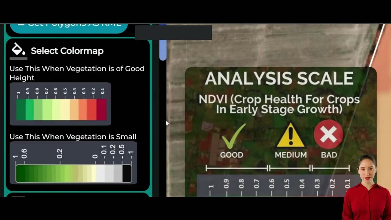
A game-changing tool here is the Normalized Difference Vegetation Index (NDVI). This vegetation index, derived from satellite data, accurately measures:
- Photosynthetic activity—indicating crop vitality and vigor
- Biomass accumulation and overall growth status
- Early stress signals such as water deficit, nutrient deficiencies, or pest/disease onset
By analyzing NDVI satellite data, we can pinpoint areas of the field needing targeted interventions, direct resources where most needed, and optimize yields while reducing input costs. Early detection is vital:
- Water stress can be flagged before visible wilting occurs
- Nutrient deficiencies or soil anomalies show up as changes in reflectance patterns
- Localized disease outbreaks are detected before spreading
This empowers Indian farmers to adopt precision farming technology—implementing crop health monitoring at scale for enhanced productivity and environmental sustainability.

Further Reading: How NDVI and Satellite Monitoring Empower Crop Health Management
How NDVI Satellite Data Works:
- Satellites capture the spectral reflectance of crops across visible and near-infrared bands.
- Those readings are analyzed to compute the NDVI value for each spatial pixel of the farm.
- High NDVI values indicate dense, healthy vegetation, while low values signal potential crop stress or yield loss.
These insights help farmers prioritize scouting, allocate resources efficiently, and avoid blanket sprays or unnecessary input application—resulting in smarter, more sustainable outcomes.


Discover: Farmonaut’s Large-Scale Farm Management Tools let you manage vast agricultural plots efficiently using AI-powered, satellite-driven crop monitoring and real-time insights.
Soil Mapping and Analysis: Turning Data into Decisions
Healthy soil is the foundation of high yields. Combining satellite imagery with ground-based sampling facilitates soil mapping at an unprecedented scale—something unimaginable with manual surveys alone. With these spatial maps, we can:
- Identify soil properties such as texture, moisture levels, and organic matter content
- Pinpoint nutrient deficiencies or toxicities via spectral reflectance signatures
- Support site-specific management strategies—from variable-rate fertilizer or pesticide applications to targeted irrigation
This combining of satellite data and in-situ measurements not only reduces waste but minimizes environmental impact and improves resource utilization. The days of blanket applications are giving way to precision-driven, sustainable agriculture solutions.
Explore: Farmonaut’s Carbon Footprinting tool leverages satellite data to help track, manage, and reduce the environmental impact of modern agricultural production, supporting sustainability reporting and compliance.
Variable-rate technology means inputs—from irrigation water to nutrients—can be delivered only where needed, decreasing costs and maximizing yields. Soil moisture mapping from satellites enables smarter, more targeted irrigation planning, saving our most precious resource: water.
-
Integrate satellite data easily with Farmonaut API:
API Access
|
Developer Docs

Soil Moisture Mapping: How Satellites Measure Hidden Water
Soil moisture mapping through satellites involves capturing microwave signals that penetrate the upper soil layers, reflecting back data on water content. By analyzing this data:
- Farmers can schedule irrigation precisely, preventing both under- and over-watering.
- Detect field areas with poor drainage or compaction issues.
- Align water use with crop growth stages for the highest returns.
These tools are essential for resource management and boosting production in both rainfed and irrigated regions of India.
Learn More: Crop Loan & Insurance Verification: Lenders and insurers use satellite-based assessment to verify farm area, crop health, and drought/flood impacts—making credit more accessible while reducing risk.
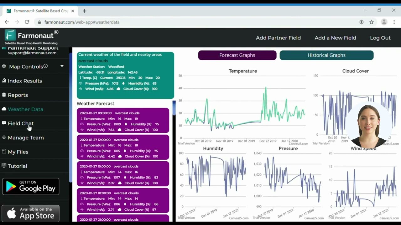
Water Resource Management for Sustainable Farming
Efficient water management remains a major challenge for Indian agriculture, especially as climate change intensifies monsoon variability and groundwater depletion.
Satellite imagery in agriculture is a game-changer, enabling:
- Field-level evapotranspiration rate analysis
- Soil moisture mapping for precise irrigation triggers
- Detection of crop water stress before physical symptoms manifest
- Integration of weather forecasts and growth models to optimize watering schedules and minimize energy consumption
With these water resource management in farming advances, we see significant conservation of water, labor, and fuel—crucial for sustainable production and food security.
Farmonaut’s data-driven platform delivers water management insights right to a farmer’s phone—transforming every field into a model of efficiency.
Explore also: Fleet Management Solutions: Ensure tractors, harvesters, and irrigation equipment operate at peak efficiency across large field plots with satellite-based fleet tracking and analytics.
Early Pest and Disease Detection: Staying Ahead of the Curve
Any sudden pest or disease outbreak can devastate Indian farms, causing huge losses. Early warning and detection are critical, but traditional monitoring can miss subtle signals until it’s too late. Here’s where satellite imagery, especially hyperspectral imaging, stands apart:
- Detects subtle reflectance changes at the plant and field scale, indicating the onset of stress, nutrient deficiencies, or incipient infections.
- Allows targeted interventions—for example, spot spraying pesticides only where risk is real—thus reducing environmental impact and avoiding blanket treatments.
- Monitors for re-infestation or recovery, supporting integrated pest management protocols.
Early pest and disease detection ensures that yield losses are minimized, inputs are optimized, and our fields remain resilient.
Did You Know? With AI-powered advisory and satellite-driven alert systems, Indian farmers now receive real-time notifications for field anomalies, helping them respond with precision.
Boost Your Traceability: Farmonaut’s Blockchain Traceability product brings transparency and trust to farm-to-market supply chains, recording every stage of crop journey using immutable satellite-verified data.
Yield Forecasting and Analysis Through Satellite Data
One of the most powerful outcomes of satellite imagery in agriculture is agricultural yield forecasting. By observing growth patterns, biomass accumulation, and environmental factors over the course of a growing season, satellites feed advanced predictive models that estimate:
- Expected production ahead of harvest
- Likely spatial variability in yields across fields or regions
- Risks posed by drought, flood, or pest outbreaks
Benefits:
- Enables more accurate supply chain planning, ensuring market stability
- Supports government agencies in policy, subsidy, and food security management
- Empowers farmers and agribusinesses with early estimates, guiding post-harvest logistics and financial planning
With NDVI satellite data and environmental observations, farmers can anticipate and adapt to changing weather patterns, reduce waste, optimize harvest timing, and maximize profitability.
“Satellite data now monitors over 100 million hectares of Indian farmland, revolutionizing precision agriculture nationwide.”
Precision Agriculture & Technological Advancements
The integration of satellite imagery in agriculture is at the heart of the precision farming technology revolution. This approach rests on two pillars:
- Collecting spatial and temporal data: Satellites constantly scan our fields, providing a steady stream of information on crop health, soil moisture, and field variability.
- Analytics and AI-powered advisory: Modern platforms, such as Farmonaut, turn raw data into actionable insights for farmers, agribusinesses, and policy makers.
The benefits are transformative:
- Optimized resource allocation: Water, fertilizer, and labor are channeled precisely where and when they’re needed, based on live data.
- Increased productivity: By enhancing yields while reducing input waste, farms become more profitable and resilient.
- Enhanced sustainability: Targeted interventions and environmental monitoring ensure healthy fields for future generations.
In India, where smallholders and large plantations coexist, scalable satellite-driven solutions are opening the door to sustainable agriculture solutions for all.
Precision Farming Technology: The Role of UAVs and Drones
Unmanned Aerial Vehicles (UAVs) equipped with multispectral or RGB cameras are also gaining traction as field-level complements to satellites. Drones provide ultra-high-resolution imagery for fine-tuned interventions—such as spot spraying or micro-irrigation—while satellites maintain field-wide and regional oversight.
Feature Comparison: Traditional vs Satellite-Based Agriculture Monitoring
| Monitoring Method | Data Frequency | Area Coverage (Ha) | Precision Level | Estimated Cost (USD/Ha) | Real-Time Capability | Sustainability Impact |
|---|---|---|---|---|---|---|
| Conventional Field Surveys | Seasonal (2-3x/year) | <10 | Low (visual/manual) | $20–$40 | No | Low (travel inputs, delayed action) |
| Drone Monitoring | Weekly/Daily (on demand) | 10–200 | Very High (sub-meter) | $10–$20 | Limited (field-by-field) | Moderate (localized, instrument energy use) |
| Satellite Imagery Solutions | Daily (cloud cover permitting) | 10–10,000+ | High (multi-spectral, NDVI) | $2–$5 | Yes (cloud/web delivery) | High (covers wide area, resource saving) |
Key Takeaway: Satellite imagery delivers the best balance of coverage, cost, and actionable agricultural insights—empowering Indian farms large or small to thrive in the era of precision agriculture.
Global Initiatives and Market Growth in Satellite Imagery
The rapid adoption of satellite data in Indian agriculture is mirrored worldwide. Major initiatives fueling this revolution include:
- European Space Agency’s Sentinel-2 program: High-resolution optical imagery supports land, sea, and agricultural monitoring across continents.
- ISRO’s Indian Remote Sensing Programme: India leads with an extensive fleet of Earth observation satellites—specifically designed for natural resource management and crop monitoring.
As a result, the market for agricultural satellite imaging exceeded USD 4 billion last year and is projected to reach nearly USD 14.19 billion by 2030, riding a robust 19% CAGR.
This explosive growth underscores the pressing need for data-driven solutions to overcome challenges in food production, water management, and sustainable resource use globally.
- What’s Driving the Market for Satellite Imagery?
- Space Data Fuels India’s Farming Innovation Drive – Reuters
- Precision Agriculture Technology Explained
Farmonaut: Satellite Imagery Solutions for Modern Agriculture
As a pioneering agricultural technology company, Farmonaut stands at the forefront of this revolution—delivering satellite-based crop health monitoring, AI-driven farm advisory, and end-to-end resource management via mobile, web, and API channels.
Farmonaut’s Key Offerings:
- Real-Time Crop Health Monitoring: Multispectral satellite imagery provides NDVI and other vegetation indices for ongoing crop health analysis, supporting early detection of stress or disease and optimizing resource allocation.
- Personalized Jeevn AI Advisory: Combining satellite, weather, and field data, Farmonaut’s AI offers customized recommendations to enhance crop yields, reduce input waste, and respond swiftly to emerging threats or opportunities.
- Blockchain-Based Traceability: Ensure full transparency and trust from farm to consumer—explore how traceability works.
- Comprehensive Resource and Fleet Management: Track, analyze, and optimize the use of all your farm machinery, water, and labor resources—fleet management details.
- Carbon Footprinting: Farmers and agribusinesses can monitor their carbon emissions, making sustainable choices and complying with environmental standards. Learn more about carbon tracking.
- Scalability for Farmers and Corporates: Individual farmers, cooperatives, agribusinesses, and institutional/government users can access tailor-made solutions at cost-effective rates—powered by satellite intelligence and machine learning.
Business Model & Accessibility
Farmonaut offers flexible, subscription-based packages as well as API access for developers. Farmers, agribusinesses, and governments can monitor any number of hectares with real-time satellite data updates, all from the comfort of web and mobile apps.
Direct App Access:
Developers & Integrators: Harness Farmonaut’s API or review the detailed API documentation for seamless integration into digital farming ventures.
Scale your plantation or forestry operation: Explore Plantation, Crop, and Forest Advisory for real-time crop and environment insights on thousands of hectares.
Challenges and the Future of Satellite Imagery in Agriculture
Despite its promise, satellite imagery in agriculture isn’t without challenges:
- Data interpretation complexity—training and intuitive platforms are required so that all farmers, regardless of background, can benefit.
- Initial investment and technology access—small and marginal farmers need affordable, accessible solutions to overcome initial cost barriers.
- Connectivity and cloud coverage—while satellites cover vast areas, heavy cloud cover can occasionally impact timely data delivery, especially during the monsoon.
- Scalability and localization—solutions must reflect India’s immense regional diversity, crop types, and varied field conditions.
However, cutting-edge platforms like Farmonaut are bridging these gaps with user-friendly apps, local language support, rapid data updates, and cost-effective subscription models—all powered by the latest global remote sensing innovations.
The Future:
- More granular, even field-level data (down to 1 meter or less)
- Seamless integration of satellite-, drone-, and IoT-based data in unified dashboards
- AI-driven recommendations and simulation models to foresee crop outcomes and climate risks
- Wider adoption of blockchain and traceability for transparent, trusted supply chains
- Support for carbon tracking and sustainability reporting
Tomorrow’s Indian agriculture will be ever more data-driven, sustainable, and precise—thanks to satellite imagery and the power of space-based insights.
Frequently Asked Questions (FAQ)
Q1: How does satellite imagery benefit Indian smallholder farmers?
Satellite imagery delivers real-time, field-specific data on crop health, soil moisture, and disease risk directly to the farmer’s mobile, eliminating expensive manual scouting. It enables better returns by guiding targeted interventions, minimizing input waste, and identifying problems early—making it accessible and valuable for farms of any size.
Q2: What is NDVI and why is it important?
NDVI (Normalized Difference Vegetation Index) is a satellite-derived vegetation index that measures plant health and photosynthetic activity. It is crucial for early detection of stress, monitoring growth, and optimizing inputs—helping Indian farmers maximize yields sustainably.
Q3: How is satellite imagery integrated into irrigation management?
Through soil moisture mapping and evapotranspiration modeling, satellite imagery recommends precisely when and where to irrigate—reducing waste, conserving water, and boosting crop yields.
Q4: Who uses Farmonaut’s satellite solutions?
Farmonaut serves a broad audience—individual farmers, agribusinesses, cooperatives, governments/NGOs, financial institutions, and corporate agrifood supply chains—offering scalable, affordable, and easy-to-use solutions for precision farming, yield prediction, resource management, blockchain traceability, and more.
Q5: Is Farmonaut a government body or input supplier?
No. Farmonaut is a technology company offering satellite-based farm monitoring applications for improved agricultural productivity, transparency, and sustainability. It does not sell farm inputs, machinery, or act as a regulatory authority.
Q6: Where can I access Farmonaut’s services?
Farmonaut services are available via web and mobile apps (Android, iOS).
Access the web app or download from Google Play or App Store.
Conclusion: Unlocking India’s Agricultural Potential with Satellite Imagery
The fusion of satellite imagery, real-time analytics, and cloud-based advisory has forever changed the future of Indian farming. With millions of hectares under space-borne supervision, farmers across the Ganges basin, Valley regions, and arid zones now harness advanced crop health monitoring, targeted resource management, and sustainable solutions—all from a mobile phone. This democratization of precision agriculture promises higher yields, smarter sustainability, and a new era of resilience for the world’s most vital breadbasket.
At Farmonaut, we’re proud to offer accessible, affordable, and cutting-edge solutions—empowering every farmer, agribusiness, and policymaker to make data-led decisions for a thriving, food-secure future.
Unlock the true power of India’s secret yields—explore satellite imagery in agriculture today!


