
Autonomous Drone Military: 7 Precision Ag Innovations
Meta Description: Autonomous drones in agriculture and forestry are driving efficiency through precision farming technologies. Discover seven data-driven innovations transforming environmental management and sustainability.
“Over 70% of new agricultural drones now feature autonomous navigation and real-time data analytics capabilities.”
Introduction: The Dawn of Autonomous Drones in Agriculture
Autonomous drones are at the forefront of technological innovation, heralding a new era in agriculture, farming, and forestry management. The fusion of military-grade advancements with precision farming technologies has enabled a paradigm shift toward data-driven agriculture and environmental management with drones. Our global population grows, demanding higher crop yields, sustainable resource optimization, and stringent environmental conservation methods. Autonomous drone solutions are answering this call — transforming everything from crop monitoring and aerial pesticide application to forest health assessment and wildfire control.
In this comprehensive guide, we explore how the adaptation of military autonomous drones has generated seven key innovations revolutionizing agriculture and forestry. We’ll examine the core technologies powering these breakthroughs, explain their benefits, and address challenges and future directions for the industry.


Why Military Drone Technology Matters in Agriculture & Forestry
Military innovation is often a precursor to civilian technological leaps, and the field of autonomous drones is no exception. The rigorous demands of defense — reliable navigation, robust communication, swarm applications, resilient sensors, and fast decision-making — have dramatically accelerated the capabilities of commercial drones. When adapted to civilian sectors like agriculture and forestry, these technologies yield new precision farming technologies that are:
- Highly autonomous: Capable of complex decision-making without direct, real-time human oversight.
- AI-enhanced: Using artificial intelligence and machine learning for real-time data analysis and recommendations.
- Networked & scalable: Functioning effectively in drone swarms for large-scale, synchronized operations.
- Durable: Operating in adverse environmental conditions, e.g., heavy smoke or poor visibility during wildfires.
Their adaptation for precision agriculture, forestry, and environmental management now offers resource managers and farmers tools previously unimaginable — turning challenging tasks into streamlined, data-driven operations.
7 Groundbreaking Innovations: Autonomous Precision Ag Drones
The leap from single remote-controlled drones to powerful, autonomous networks of intelligent aerial systems is transforming how we approach crop and forest management. Here, we highlight the seven major innovations brought by autonomous drones in agriculture and forestry today, focusing on their unique capabilities, real-world applications, and their estimated impact.
-
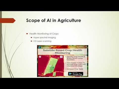
Multispectral and Infrared Drone Sensors for Early Crop Health Detection
Multispectral drone sensors and infrared cameras enable advanced crop monitoring solutions. These sensors, mounted on drones, gather layers of reflected light beyond human vision, providing invaluable insights into vegetation health, soil analysis, moisture, nutrient deficiencies, and emerging crop diseases. By detecting early signs of pest infestations and stress, farmers can implement timely interventions and dramatically reduce chemical usage.
- Data accuracy is exceptionally high, revealing even subtle signs of plant stress before visible symptoms appear.
- Supports precision input application, improving sustainability and yield.
-
Swarm-Based Drone Applications for Large-Scale Surveying and Input Application
Drawing inspiration from military research, drone swarm applications leverage coordinated, decentralized fleets to vast effect. A coordinated swarm allows for near-simultaneous area coverage during aerial pesticide or fertilizer application, land surveying, or data collection. With one operator managing dozens — even hundreds — of drones, this innovation fundamentally boosts operational efficiency and minimizes labor costs.
- AI-driven swarms can avoid collisions and dynamically plan trajectories, optimizing coverage over complex terrain.
- Swarm-based resource deployment ensures uniform distribution of inputs, minimizing environmental impact.
-
Autonomous Aerial Spraying for Targeted Pesticide and Fertilizer Delivery
Modern agricultural drones such as the DJI Agras series are designed for precise aerial delivery of pesticides and fertilizers. These systems have revolutionized input distribution by targeting only the areas that require treatment — based on drone-captured or satellite-based crop health data — rather than broadcasting chemicals across entire fields.
- Resource optimization in farming: Reduces costs, labor hours, and environmental footprint.
- Enhances safety by reducing human exposure to chemicals.
-
Precision 3D Mapping and Soil Analysis using LiDAR-equipped Drones
LiDAR-armed drones fly above fields and forests to generate richly detailed 3D maps of terrain and vegetation structure. These data sets are crucial not only for soil property assessment and drainage planning but also for identifying microclimates, tree health, and even optimal planting patterns.
- Accommodates precision land management and supports informed decisions in both agriculture and forestry.
- LiDAR mapping is a critical foundation for advanced sustainable forestry practices and conservation efforts.
-
Autonomous Drone Systems for Wildfire Detection and Targeted Suppression
Wildfires present a mounting threat to ecosystems and rural communities. Now, autonomous drones equipped with thermal sensors and payload systems can detect early heat signatures and even dispatch fire retardants or water to precise ignition points. Companies like FireSwarm Solutions are developing fleets capable of operating in harsh conditions, including heavy smoke and at nighttime, significantly accelerating response times and reducing risks to human crews.
- Environmental management with drones: Enhances ecosystem resilience, enables data-driven decisions in forest management.
- Drones relay real-time updates to inform firefighting teams and resource deployment.
-
AI-Powered Predictive Analytics and Decision Support Systems
The integration of artificial intelligence in drone-based agriculture involves predictive modeling for yield estimation, pest outbreak prediction, and even optimization of planting and harvest schedules. These advanced agricultural drones combine real-time data streams from multispectral cameras and environmental sensors with deep learning algorithms for unrivalled management guidance.
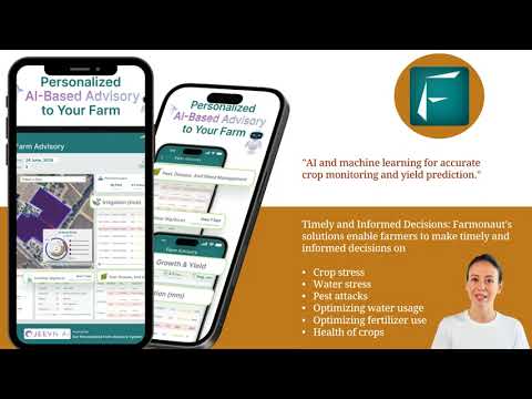
- Farmonaut’s Jeevn AI Advisory System: Delivers personalized advice to optimize resources and minimize crop losses (learn more about Farmonaut’s advisory features).
- AI-driven decisions are essential in large-scale farm management — see how Farmonaut’s Agro Admin App scales with growing operations.
-
Real-Time Blockchain Traceability via Drone-Collected & Satellite Data
To meet growing demands for supply chain transparency, drone and satellite-sourced data are now secured using blockchain technology — as pioneered by platforms like Farmonaut. This ensures every input, activity, and product movement is reliably recorded, enhancing traceability and reducing fraud, particularly for crops, timber, and resource commodities.
- Transparent, tamper-proof records from seed to market (more on traceability solutions here).
- Empowers compliance, financing, and environmental certifications.
“Precision drone fleets can survey up to 1,000 hectares of farmland in a single day using advanced AI algorithms.”


Comparison Table of Key Precision Ag Drone Innovations
Below is a concise comparison of the seven featured autonomous drone innovations, including quantitative estimates to help you gauge their potential impact in practical applications:
| Innovation Name | Primary Function | Estimated Yield Improvement (%) | Data Accuracy Level | Area Coverage per Flight (ha) | Estimated Cost Savings (%) | Suitable Crop/Forest Types |
|---|---|---|---|---|---|---|
| Multispectral & Infrared Drone Sensors | Early Crop Health, Nutrient, & Stress Detection | 10-15% | High | 200-500+ | 10-20% | All field and specialty crops |
| Swarm-Based Drone Applications | Mass Surveying & Coordinated Input Application | 12-18% | High | 1,000+ | 20-30% | Large plantations, cereal crops, forests |
| Autonomous Aerial Spraying | Targeted Pesticide & Fertilizer Delivery | 10-20% | High | 300-700 | 15-25% | Paddy, wheat, sugarcane, apple orchards |
| LiDAR-Based 3D Mapping | Topography & Soil Structure Analysis | 8-12% | High | 200-400 | 10-18% | Forests, orchards, hillsides, vineyards |
| Autonomous Wildfire Detection & Suppression | Early Fire Detection, Retardant/Aid Delivery | n/a | High | Varies (event-driven) | Reduces resource losses | All forests, grasslands |
| AI-Powered Predictive Analytics | Yield, Pest, Weather Forecasting | 10-15% | High | All areas (cloud-based) | 10-20% | All crop/forest types |
| Blockchain Traceability Solutions | Supply Chain Transparency, Compliance | n/a | High | All commercial scale | Mitigates fraud, enhances value | Export crops, timber, commodities |
Data-Driven Agriculture: Advanced Sensors and AI Integration
Modern precision farming technologies are built upon vast streams of data, collected by autonomous drones, satellites, and remote sensing tools. These technologies harness multispectral, thermal, and LiDAR sensors to capture detailed imagery and actionable field metrics — such as crop vigor, soil moisture, and disease stress.
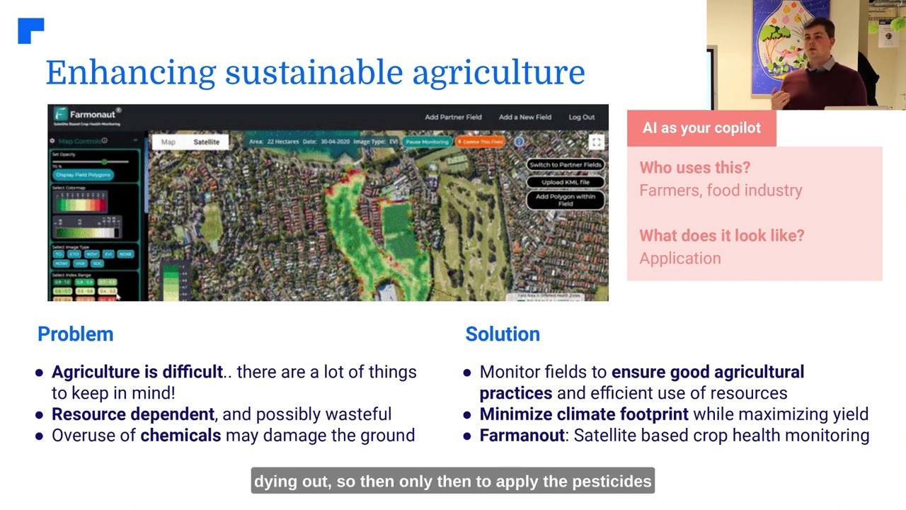
- Farmonaut’s Satellite-based Crop Health Monitoring uses multispectral satellite imagery for real-time assessment — accessible via web/mobile app and API (see our API or developer documentation).
- AI-powered insights: Machine learning algorithms quickly analyze incoming data, flag risks, and provide actionable recommendations, from irrigation scheduling to pest management.
- Resource optimization in farming: Data analytics reduces waste of water, fertilizers, and pesticides by honing in on exactly when and where application is needed.
Collectively, these solutions enable more informed, sustainable, and efficient practices — core principles of environmental management with drones.
Precision Forestry & Environmental Management with Drones
Drones aren’t only changing agriculture; they’re equally valuable in forestry and environmental sectors. Autonomous drones now perform tasks such as:
- Forest health monitoring: LiDAR and multispectral-equipped drones assess canopy density, detect signs of disease or pest infestations, and spot nutrient deficiencies — all crucial for maintaining sustainable forestry practices.
- Biodiversity assessment: Advanced imaging enables monitoring of flora diversity, supporting conservation and resource management strategies.
- Habitat mapping: Drone-generated 3D maps identify sensitive zones and inform selective logging, restoration, and habitat protection plans.
- Wildfire management: AI-enhanced drones act as early warning systems and deliver direct firefighting payloads under challenging conditions.
To streamline these operations, fleet management tools are increasingly important. Farmonaut’s fleet management solutions allow agribusinesses and forestry managers to optimize vehicle and drone deployments, ensuring maximum efficiency, safety, and cost savings.
Reducing the carbon footprint of agricultural and forestry operations is a growing concern. Farmonaut’s carbon footprint monitoring tools help track emissions, enabling businesses to adopt more sustainable practices and comply with evolving environmental standards.
Farmonaut: Making Precision Agriculture Accessible for All
At Farmonaut, our mission is to democratize precision agriculture and make it accessible and affordable for farmers, agribusinesses, and governments worldwide. We leverage the combined strength of satellite technology, AI, and blockchain innovation to support smarter resource optimization in farming, boost productivity, and enable sustainable agricultural practices.
- Easy accessibility: Our platform is available via Android, iOS, web/browser app, and API — so whether you’re a smallholder or a large-scale operator, you can access actionable insights from anywhere.
- Scalable subscriptions: Choose from flexible packages based on hectares monitored and update frequency (see pricing below).
- Real-time advisory and traceability: Our Jeevn AI offers instant risk alerts and data-driven advice, while blockchain traceability adds supply chain transparency from farm to fork.
- Support for carbon footprint tracking and advancement of environmental stewardship at farm and corporate scale.
To maximize flexibility and support integration with other digital agritech platforms, our API and developer documentation enable seamless access to satellite, weather, and crop data. Financial institutions can benefit from satellite-based crop loan and insurance verification (explore crop loan and insurance verification), reducing fraud and streamlining approvals.
Challenges and Considerations in Drone Adoption
Despite their vast benefits, autonomous drones in agriculture and forestry still face several deployment challenges:
- Regulatory concerns: Varying country-specific legal frameworks for drone usage — especially regarding autonomous and swarm operations — can complicate scaled deployment.
- Privacy and data security: Public acceptance may be affected by surveillance worries; robust encryption and transparent data handling are essential.
- Operator skills gap: While drones are increasingly autonomous, operators still require training to oversee systems and interpret analytics.
- Environmental impact: While drones help reduce chemical usage and improve sustainability, consideration must be given to battery/environmental impacts related to drone production and operation.
Addressing these challenges will require ongoing innovation, clear communication, and industry-wide collaboration between technology providers, regulators, and end-users.
The Future of Autonomous Drones in Agriculture & Forestry
The outlook for autonomous drones in agriculture and forestry is bright. Continued advances in artificial intelligence, machine learning, and sensor miniaturization will enable even greater autonomy, data granularity, and cost-effectiveness. We expect future precision farming systems to feature:
- Fully connected operations: Ground, aerial, and satellite data will be seamlessly integrated, offering a comprehensive, real-time view of crop and forest health.
- Autonomous drone swarms: One operator will control entire fleets, allowing dynamic re-routing, obstacle avoidance, and real-time collaboration across vast, diverse landscapes.
- AI-powered decision systems: AI engines will recommend not only “what” action to take, but “when”, “where”, and “how much”, for truly optimized management.
- Blockchain-powered supply chains: Complete transparency and trust, from planting to harvest to market — boosting food safety, quality, and sustainability.
As regulatory frameworks evolve and technology becomes more accessible, the integration of drones in environmental management will lead to more sustainable forestry practices, improved yields, enhanced resource efficiency, and greater global food and environmental security.
FAQ: Autonomous Drones in Agriculture & Forestry
What are the primary benefits of autonomous drones in agriculture?
Autonomy enables drones to efficiently perform repetitive, labor-intensive tasks (like crop monitoring, pesticide spraying, and surveying) with high precision, reducing labor costs, increasing yield, and minimizing chemical usage — all while providing highly accurate, real-time data for improved farm management.
How do drone swarms improve large-scale farm operations?
Swarm technology allows a single operator to control many drones, enabling rapid, simultaneous coverage of large areas for survey and input application. AI-driven path planning ensures efficiency, safety, and optimal distribution of resources.
What type of sensors are most commonly used in agricultural drones?
The most common are multispectral (for vegetation health monitoring), infrared (for heat, moisture, and plant stress), LiDAR (for topographical and structural mapping), and thermal cameras (for pest/disease and fire detection).
How does blockchain enhance food and forest product traceability?
Blockchain records every action, movement, and input in a tamper-proof digital ledger, providing complete transparency from planting to sale. This is vital for compliance, safety, and market differentiation.
Can small farmers afford precision drone solutions?
Thanks to platforms like Farmonaut, precision data is now affordable and accessible for all scales of farmers, eliminating the need for expensive on-farm hardware by leveraging satellite and cloud-based analytics.
Are there any environmental downsides to drone usage?
While drones themselves help reduce chemical and water use, their batteries and production processes do have environmental footprints. Opting for energy-efficient drones, recycling components, and supporting sustainable manufacturing can help mitigate negative impacts.
Further Reading & Resources:
- Farmonaut Crop Plantation & Forest Advisory: Unlock insights for plantation, crop planning, and forestry management.
- Farmonaut Carbon Footprinting: Track and reduce your carbon footprint in agriculture and agroforestry — learn more here.
- API & Integration: Seamless API and developer docs for automating your digital agriculture workflows.
- Farmonaut Fleet Management: Optimize logistics and resource allocation for agricultural fleets and drone operations. See our cutting-edge fleet management tools.
- Large Scale Farm Management: Discover how Farmonaut’s Agro Admin App enables multi-operator, enterprise-grade monitoring across thousands of hectares.
Conclusion
The integration of military-developed autonomous drone systems into civilian precision agriculture and forestry is revolutionizing how we manage land, resources, and sustainability at scale. With tools like multispectral drone sensors, LiDAR mapping, AI-powered decision platforms, and blockchain transparency, the future of data-driven agriculture is smarter, safer, and more efficient than ever. While challenges persist, the shift to autonomous and digitally empowered operations has never been more necessary — or more achievable. At Farmonaut, we’re dedicated to making these innovations accessible to all, enabling a new era of productivity and environmental stewardship worldwide.


