
Table of Contents
- Introduction
- Trivia: GPS Technology Facts
- How GPS Navigation Powers Precision Crop Monitoring
- Comparison Table: 7 Benefits of GPS Navigation
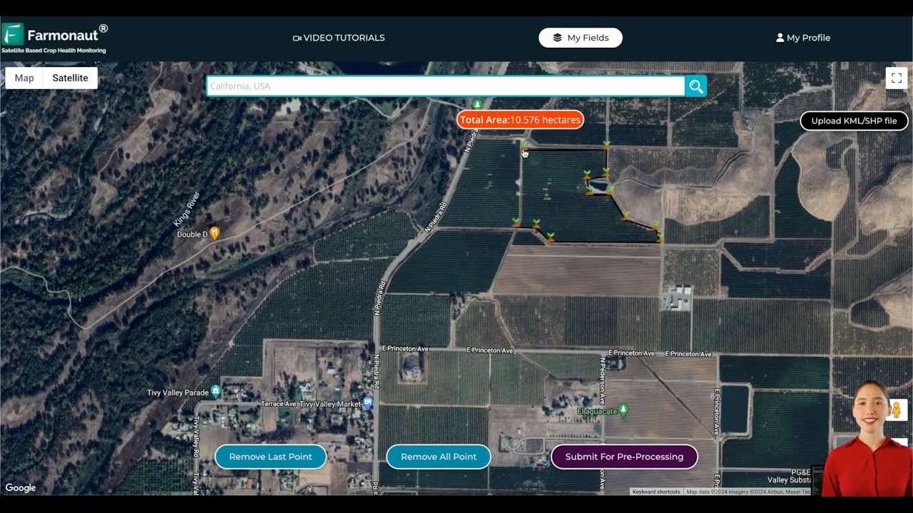
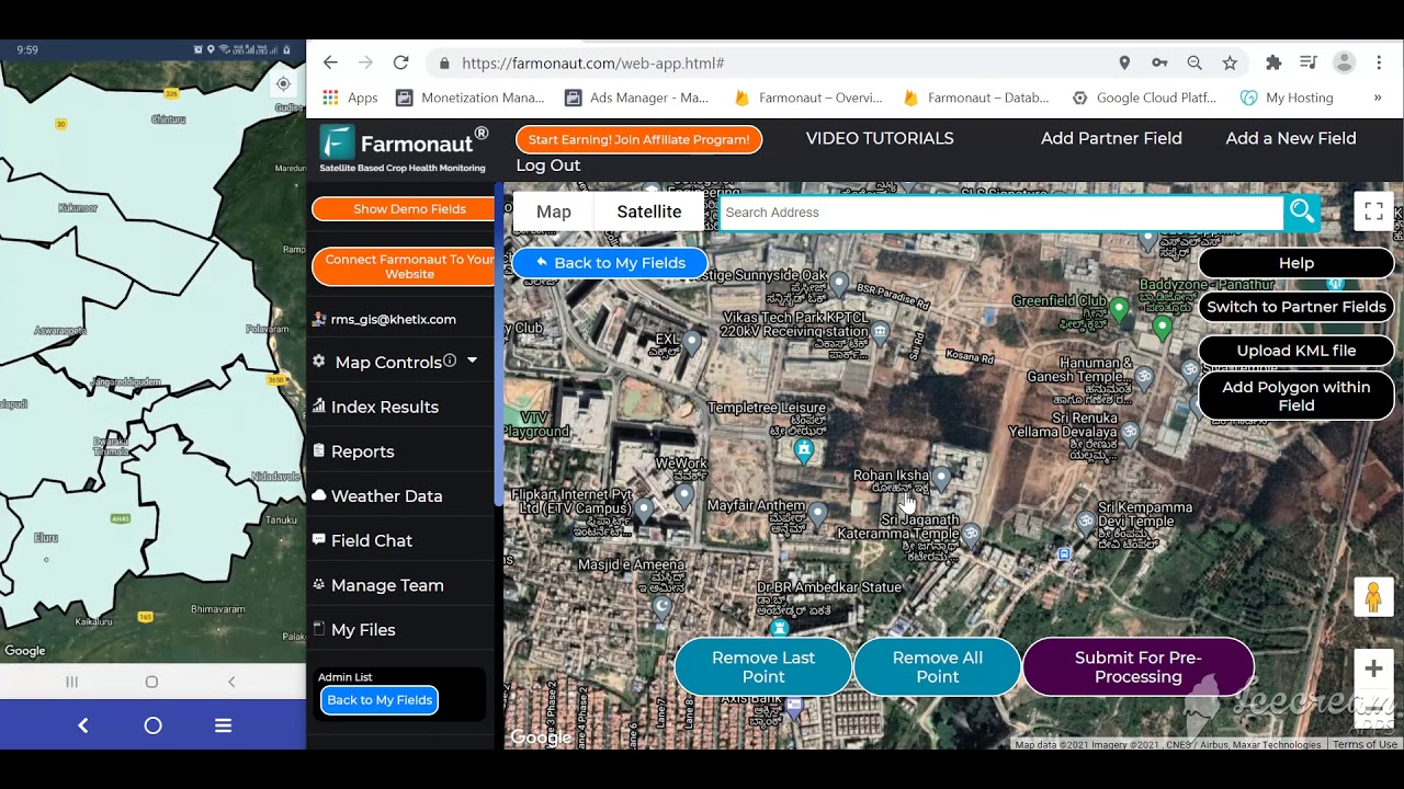
- 1. Field Mapping and Surveying
- 2. Precision Planting & Crop Management
- 3. Real-Time Monitoring & Data Collection
- 4. Automated Guidance and Steering
- 5. Variable Rate Technology (VRT)
- 6. Data-Driven Decision Making
- 7. Integration with Other Technologies
- GPS in Precision Forestry Applications
- Farmonaut: Democratizing Precision Farming Technology
- Farmonaut Subscriptions & Getting Started
- FAQ: GPS Navigation & Precision Crop Monitoring
- Conclusion
GPS Navigation: 7 Benefits for Precision Crop Monitoring
Global Positioning System (GPS) technology is transforming agriculture, farming, and forestry—ushering in a new era of efficiency, productivity, and sustainability through the power of precision farming technology. Whether you are an individual farmer managing a small plot of land or an agribusiness overseeing thousands of hectares, GPS navigation equips you with actionable, real-time data to optimize crop monitoring, resource allocation, and operational outcomes.
“GPS-guided tractors can reduce field overlap by up to 90%, saving significant fuel and time in crop monitoring.”

How GPS Navigation Powers Precision Crop Monitoring
The integration of GPS in agriculture, paired with advanced crop monitoring systems, propels the industry forward with accurate location data, field mapping, and optimized resource management. Technologies like Farmonaut’s platform combine satellite imaging, AI, and GPS for a holistic approach—enabling real-time monitoring, variable rate technology in farming, and seamless automated guidance for tractors and machinery.
- Precision in Planting & Inputs: GPS-driven machinery ensures accuracy in seeding, fertilizer, and pesticide application—reducing input waste and environmental impact.
- Efficiency in Operations: Mapping and navigation reduces overlap, lowers costs, and delivers measurable time and fuel savings.
- Comprehensive Monitoring: Real-time data collection enhances visibility into crop health, growth patterns, soil fertility mapping, and yield performance.
- Sustainable Practices: GPS supports resource-efficient farming and can be paired with carbon tracking for better environmental outcomes.


“Precision farming with GPS boosts crop yields by an average of 15% through optimized field management and real-time data.”


Comparison Table: 7 Benefits of GPS Navigation in Agriculture
| Benefit | How GPS Enables This Benefit | Estimated Impact (% Improvement or Time Saved) |
|---|---|---|
| Accurate Field Mapping & Surveying | Enables farmers to map field boundaries, highlight soil fertility, drainage, and topography variations using GPS devices. |
Yield increase: up to 10% |
| Precision Planting & Crop Management | Guides machinery to plant seeds at optimal depths and spacing, and allows targeted input application. | Resource efficiency: up to 20% less input wastage |
| Real-Time Monitoring & Data Collection | Tracks operational data, crop health, equipment status — assisting early detection of issues. | Monitoring time saved: 30%+ |
| Automated Guidance & Steering | Steers tractors and machinery accurately, reducing overlap and human error. | Fuel and labor savings: up to 15–20% |
| Variable Rate Technology (VRT) | Applies fertilizers, irrigation, or pesticides variably based on actual field needs. | Input savings: 10–25% |
| Data-Driven Decision Making | Aggregates GPS and sensor data for farm analytics, trend-spotting, and actionable insights. | Overall productivity boost: up to 20% |
| Integration with Other Technologies | Links GPS with remote sensing, drones, AI for improved detection of disease, stress, or nutrient issues. | Enhanced yield and early intervention: variable, up to 15% |
1. Field Mapping and Surveying: Establishing the Foundation
Accurate field mapping and surveying is the cornerstone of precision farming technology. Using GPS-enabled devices, farmers can precisely map fields, capture boundaries, and record intricate details such as:
- Variations in soil fertility and moisture
- Topography and drainage patterns
- Historical and current field data for analysis
Such detailed mapping forms the basis for efficient resource allocation, input optimization, and management of future farming activities. By understanding the unique characteristics and variability across their land parcels, farmers can tailor their seeding, irrigation, and fertilization strategies—linking every action to a specific location and need.
Key Aspects of Field Mapping and Surveying
- Boundary Collection: Defining and recording field edges with sub-meter accuracy for better land management and accurate reporting.
- Soil Fertility Mapping: Creating detailed maps based on soil sampling patterns and GPS positioning to guide input decisions.
- Topographic Surveying: Identifying elevation changes and water flow patterns to address drainage issues and reduce erosion risk.
- Yield Mapping: Integrating with yield monitors for spatial yield data.
Such precision minimizes resource waste, boosts yield, and forms the bedrock of all subsequent precision crop monitoring systems. Using platforms such as Farmonaut, users can remotely delineate fields and access up-to-date satellite-based crop health and soil fertility mapping from any device.
Want to map your fields effortlessly and start using GPS-powered crop monitoring? Try Farmonaut’s mapping tools now →
2. Precision Planting and GPS Crop Management: Enhanced Efficiency at Every Step
GPS guidance in agriculture has ushered in a revolution in both planting and crop management. By leveraging satellite positioning, machinery can execute operations like seed drilling, fertilization, and spraying with unparalleled accuracy.
- Seeds are planted at optimal depths and precise spacing, leading to uniform crop emergence and growth.
- Fertilizer and pesticide inputs can be targeted only where needed, avoiding blanket applications and lowering costs.
- Overlaps and missed areas are minimized, ensuring effective resource utilization and boosting yield.
GPS Crop Management System: Key Advantages
- Automated GPS-Enabled Planters: Planting units follow pre-set rows and patterns, reducing competition between plants for light, water, and nutrients.
- Section Control: Modern GPS-guided planters automatically switch off sections to prevent over-seeding or double planting in already covered zones.
- Input Savings: Applying the precise amount of fertilizers and pesticides lowers chemical use, saving 10–20% on input costs.
- Environmental Impact: Reduced chemical drift protects surrounding ecosystems.
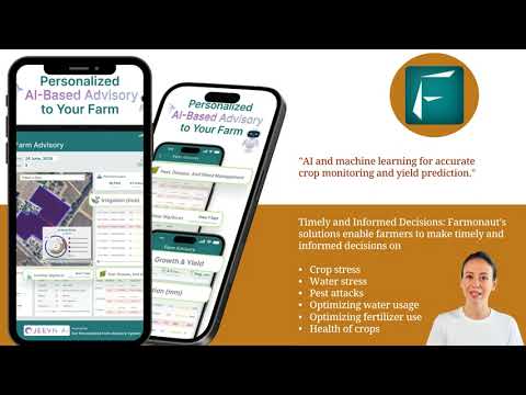
Optimized planting and input strategies deliver a direct boost in yields and operational efficiencies. These gains are amplified when users pair GPS crop management with real-time crop health monitoring tools, such as those provided by Farmonaut’s Jeevn AI advisory system for timely, data-based decisions.
Looking for advanced solutions to optimize every planting and management operation? Farmonaut offers GPS-integrated crop management via app and API →
3. Real-Time Farm Data Collection & Monitoring: Stay Ahead of Every Decision
Modern crop monitoring systems depend on reliable, real-time data from both sensors and GPS systems. GPS receivers on farm vehicles and equipment enable ongoing data collection during every field operation, allowing for:
- Live updates on equipment positioning and performance
- Yield mapping and spatial analysis of productivity across the field
- Soil moisture and climate monitoring for proactive irrigation and drought management
- Rapid identification of crop stress, pest infestations, or nutrient deficiencies
Farmers and managers can access these actionable, granular datasets directly via modern digital tools. For example, at Farmonaut, we provide:
- Satellite-based crop health monitoring—track NDVI (vegetation index), water stress, and field anomalies via app or API
- Automated alerts for unusual weather, pest risk, or sudden yield drops (see Farmonaut API or developer docs)
- Integration with machinery fleet management and resource optimization tools—minimize downtime, track inputs, and streamline harvesting
The more comprehensive and real-time your farm data collection, the better your decisions, response times, and overall operational efficiency become.
Transform the way you monitor your crops. Explore Farmonaut API for seamless farm data integration →
4. Automated Guidance for Tractors & Machinery: Precision Across Every Pass
Automated GPS guidance and steering systems have redefined modern farming operations. By leveraging satellite signals, they maintain exact vehicle positioning, enable hands-free steering, and reduce human error. The most advanced systems even operate tractors and machinery autonomously across vast fields.
- Consistent machinery pathing: Every row, pass, and action is performed with high repeatability, ensuring even coverage and optimized input use.
- Overlap reduction: With GPS, field overlaps can be cut by as much as 90%—saving fuel, time, and money.
- Labor savings: Automated steering reduces operator fatigue and improves overall safety.
- Task scheduling: Programs machinery to follow set routes for tillage, planting, spraying, and harvesting.
Whether using manual GPS guidance or full-fledged auto-steer, these systems deliver measurable gains:
- Fuel and input cost reduction (by up to 20%)
- Time and labor efficiency improvements
- Greater precision in planting, spraying, and harvesting—directly enhancing yield and field health
Automated guidance technology is the key to truly scalable and efficient field operations for both small and large farm enterprises.
Ready to bring precision guidance to your fields? Farmonaut’s Fleet Management platform streamlines machinery tracking and route optimization.
5. Variable Rate Technology in Farming: Only Apply What’s Needed
GPS-guided Variable Rate Technology (VRT) empowers farmers to apply fertilizers, seeds, water, and pesticides at rates tailored to each field zone’s unique conditions. Instead of uniform, blanket applications, VRT analyzes data on soil fertility, nutrient levels, moisture, and yield potential—and then modulates input amounts at a micro level.
- Resource optimization: Inputs only go where they are most needed, maximizing effect and minimizing waste.
- Environmental impact: Lowered runoff, soil leaching, and chemical overuse protect local ecosystems.
- Cost savings: Typical VRT systems save farmers 10–25% on input expenses, while maintaining or boosting yield.
- In-season adaptability: As field conditions change, so too do application rates—using data from GPS, remote sensing, and soil sensors.
Want to use VRT without huge hardware costs? Solutions like Farmonaut’s mobile and web platform use satellite data to advise variable rate irrigation and fertilization for users at all operational scales, democratizing precision!
VRT is one of the biggest drivers of sustainable agriculture—delivering quantifiable ROI and environmental stewardship in every acre.
Need more on precision resource application? Check out Farmonaut’s Carbon Footprinting tools for measuring and reducing the environmental footprint of your VRT-enabled operations.
6. Data-Driven Decision Making: From GPS Data to Actionable Insights
The real power of GPS in agriculture isn’t just in navigation; it’s in the data-driven decision making enabled by seamlessly combining GPS, sensor, and remote sensing data. When farmers utilize platforms aggregating this data—such as those offered by Farmonaut, they are able to:
- Analyze trends in crop growth, input efficiency, pest outbreaks, and yield
- Identify zones of opportunity and challenge within a field
- Optimize crop rotation based on soil health and historical field performance
- Schedule timely interventions for irrigation, fertilization, and pest management
- Reduce losses and costs by acting on predictive alerts from Jeevn AI and satellite monitoring
Combining GPS with advanced analytics means every decision, allocation, and management action is backed by evidence and precision—amplifying ROI and productivity year after year.
For seamless crop traceability and operational transparency, see how Farmonaut’s blockchain-based traceability revolutionizes supply chains, both for food processors and textile producers.
7. Integration with Remote Sensing & Emerging Agri-Tech: The Power of Synergy
GPS technology’s true impact is realized when integrated with remote sensing technologies, drones, satellite imaging, AI, and data analytics. Together, these technologies unlock:
- High-resolution monitoring: Drones and satellites produce detailed maps showing crop health, disease stress, pest infestations, and nutrient deficits across fields.
- Proactive management: GPS coordinates link each issue to an actionable location, allowing targeted field scouting and precise remedial sprays or nutrition.
- Mechanical site preparation: GPS-enabled bulldozers and land prep equipment ready fields for planting with surgical accuracy.
- AI-powered recommendations: Automated advisories based on aggregated weather, soil, yield, and remote sensing data.
Such integration is now accessible and affordable for fields of all sizes, via solutions like Farmonaut’s large-scale farm management suite.
This seamless technology synergy enables unprecedented precision, sustainability, and crop performance in agriculture.
GPS in Forestry: Sustainable Management & Monitoring
The use of GPS technology in forestry is increasingly vital for sustainable resource management, forest health monitoring, and operational planning. Key forestry applications for GPS include:
- Pre- and Post-Harvest Cut Block Traversing: Efficient navigation and mapping minimize environmental disruption and ensure regulatory compliance.
- Road Systems & Landings: Plan and maintain access routes for vehicles transporting logs and materials, reducing ecological impact.
- Mechanical Site Preparation: Precision mechanical brushing and planting of juvenile trees improves forest regeneration and soil health.
- Juvenile Tree Spacing & Planting: Enables accurate spacing, promoting healthy growth patterns and enhanced timber yield.
- Forest Health Monitoring with GPS: Early detection of insect outbreaks, disease, or fire using integrated GPS and remote sensing data.
- Forest Fire Monitoring: Real-time GPS data guides emergency response teams to affected zones.
- Establishing and Monitoring Research Plots: Ensures precise location data for longitudinal studies and data collection.
Such forest management practices support biodiversity, carbon sequestration, and a more sustainable forestry sector. Farmonaut’s crop plantation and forestry advisory solutions are specifically tailored for these use cases—delivering actionable geo-referenced data for forestry professionals, NGOs, and government agencies.
Learn more about Farmonaut’s crop plantation and forest advisory toolkit.
Farmonaut: Democratizing Precision Farming Technology with GPS & Real-Time Data
At Farmonaut, we blend the latest advancements in satellite-based crop health monitoring, GPS navigation, AI, and blockchain to democratize precision farming technology. Our mission is to make these innovative solutions affordable and accessible for farmers, agribusinesses, governments, and other agricultural stakeholders worldwide.
- Satellite Monitoring: We deliver ready-to-use NDVI, soil moisture, and crop health insights from multispectral satellite imagery, eliminating the need for costly on-ground sensors or drones.
- AI Advisory (Jeevn): Our Jeevn AI system sends personalized, real-time advice on input application, irrigation, and best practices—powered by GPS, remote sensing, and local weather.
- Blockchain Traceability: We secure supply chains and rebuild consumer trust with verifiable, GPS-tagged traceability for every batch of harvested produce (see details).
- Fleet, Equipment, and Resource Optimization: Our fleet management tools help agribusinesses reduce operational costs via GPS-based vehicle tracking.
- Environmental & Carbon Management: Through carbon footprinting features, we support emissions reduction and sustainable certification.
- Financial Verification: GPS and satellite verification streamline the crop loan and insurance process, improving access to credit and diversification for global farmers.
Unlike traditional precision ag tech, Farmonaut’s solution is fully digital—no costly hardware required. This makes high-precision, data-driven agriculture possible for everyone from smallholders to government agencies.
Our Value Proposition
- Cost-Effective Performance: Real-time crop insights and GPS-driven optimizations at a fraction of legacy system costs.
- True Scalability: From 1 to 10,000+ acres, instantly accessible via web, Android, and iOS apps, as well as API integration.
- Sustainability at Core: Every feature helps minimize waste and environmental impact.
To experience the future of crop monitoring and operational management:
- Access Farmonaut—Available on iOS, Android, and Web!
- For agro-enterprises & researchers: Integrate Farmonaut via RESTful API
Farmonaut Subscriptions & Getting Started
Choose the right plan and unlock access to all our platform features:
Frequently Asked Questions about GPS Navigation & Precision Crop Monitoring
What is GPS navigation in agriculture?
GPS navigation in agriculture refers to the use of global positioning systems in guiding machinery, mapping fields, monitoring crops, and collecting real-time data to enhance farm management precision.
How does GPS reduce costs for farmers?
GPS minimizes resource wastage by reducing field overlaps, targeting inputs, and automating operations—saving fuel, fertilizers, pesticides, and labor costs while improving yields.
What is variable rate technology (VRT) and how does GPS enable it?
Variable rate technology in farming uses GPS data to apply inputs at rates suited to specific field zones, optimizing use according to soil fertility, moisture, and crop needs—improving efficiency and sustainability.
Can GPS in agriculture help small and medium farmers?
Yes! Affordable services like Farmonaut’s app and API make GPS-based precision farming accessible even for smallholders—no expensive machinery needed.
How does GPS facilitate crop health monitoring?
By enabling accurate location tagging of satellite imagery, sensor readings, and yield data, GPS supports deeper analysis and timely interventions for crop health, irrigation, and disease management.
Which crops and regions benefit most from GPS navigation?
While GPS navigation works for any crop, it’s especially impactful in row-crop farming (corn, soy, wheat, sugarcane, cotton) and in regions with high field variability or labor constraints. Regions with growing focus on sustainability and traceability across Asia, North America, and Europe see major gains.
What about forest monitoring using GPS?
GPS supports forest health monitoring by automating data collection, aiding in fire tracking, insect infestation monitoring, and supporting sustainable logging and reforestation planning. See Farmonaut’s forest advisory toolkit for real-time forestry solutions.
Conclusion: A New Era for Precision Agriculture & Forestry
GPS navigation is more than just a location tool—it’s the foundation of precision farming and forestry management. From detailed field mapping and efficient planting to real-time monitoring and sustainable resource deployment, GPS revolutionizes every aspect of modern food and fiber production. When paired with remote sensing, AI, and digital advisory platforms, such as Farmonaut, the result is a future where productivity, sustainability, and resilience are not only possible—but accessible to every stakeholder in agriculture and forestry globally.
Leveraging GPS means smarter decisions, optimized resource use, and measurable environmental benefits. Start your journey—experience Farmonaut’s GPS-powered crop and forestry solutions today.


