Clarksville Flood Crisis: Essential Safety Guide and Recovery Resources for Tennessee Residents
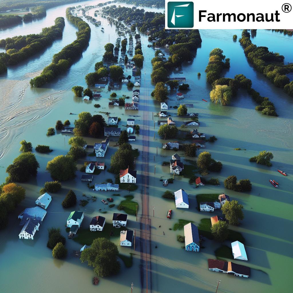
“The Red River in Clarksville is expected to crest at 46.8 feet, marking the third-highest flood crest on record.”
As we face an unprecedented flood crisis in Clarksville and surrounding areas of Tennessee, our community stands united in the face of adversity. The recent storms have brought about severe flooding, prompting numerous Clarksville flood rescues and highlighting the significant Red River flooding impact. In this comprehensive guide, we’ll provide vital information on flood-affected areas in Nashville and Clarksville, detailing the Cumberland River flood forecast, and offering essential Clarksville flood safety measures and recovery resources.
Understanding the Severity of the Situation
The flooding in Clarksville has reached critical levels, with the Cumberland River flood forecast predicting unprecedented water levels. As of the latest reports, the Red River is expected to crest at a staggering 46.8 feet, marking the third-highest flood crest on record. This alarming statistic underscores the gravity of the situation and the need for immediate action and preparedness.
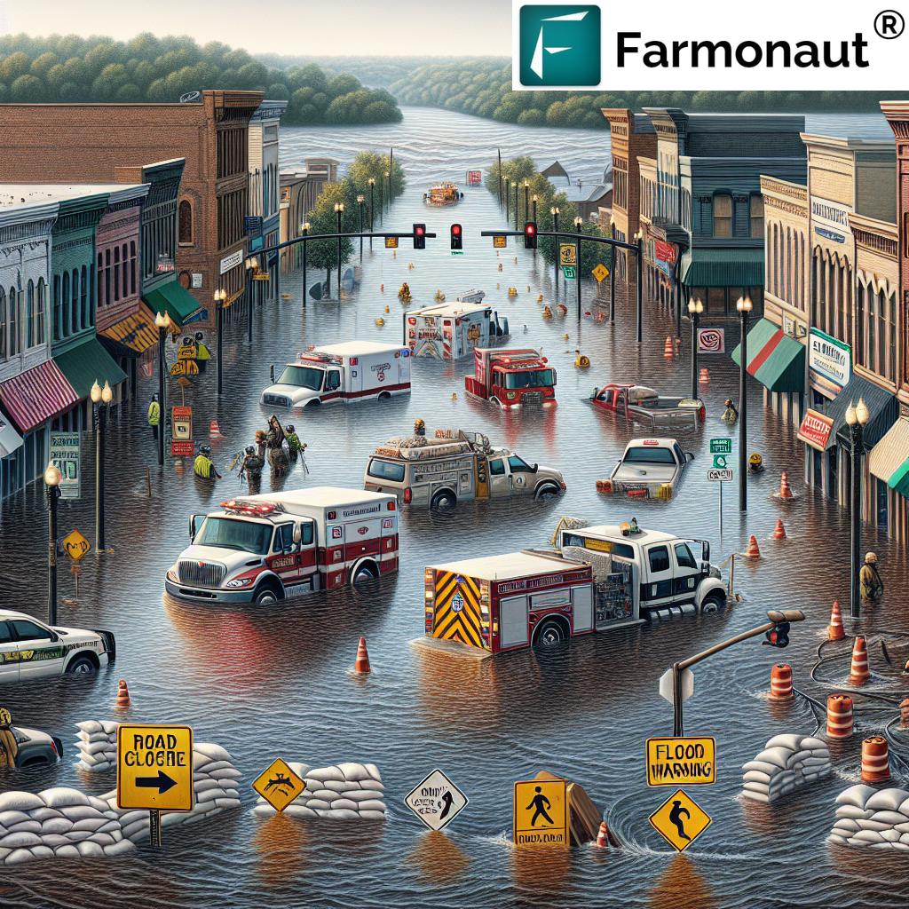
Clarksville Fire Rescue has been working tirelessly, responding to more than a dozen rescues in the wake of the weekend’s storms. The Clarksville Rescue Chief reported that 27 people had been pulled from their homes on Sunday alone, highlighting the ongoing danger and the crucial role of our emergency services.
River Flood Stages and Their Impact
To better understand the scope of the flooding, let’s break down the river flood stages and their effects on specific locations, as provided by the U.S. Army Corps of Engineers:
Red River at Port Royal
- 36 feet: Flooding affects agricultural land, parks, and access areas along the river, including Red River Valley Park. Water reaches campsites, and evacuations may be necessary. Port Royal Road near Highway 238 is covered in water.
- 38 feet: Significant flooding impacts agricultural land, parks, and access areas. Several campsites in Red River Valley Park are flooded. Water approaches Dunbar Cave Road west of Warfield Boulevard.
- 40 feet: Flooding continues to affect areas along the river. Water reaches yards of homes on Rivermont Drive, River Run, Idlewood Drive, and Wimbledon Court.
- 42 feet: Flood waters approach homes in various areas, including Rivermont Drive, River Run, and Idlewood Drive. Roads become impassable, including Port Royal Road near Highway 238.
- 44 feet: Water reaches homes on several streets and approaches yards of homes on others. The Port Royal State Park Trail of Tears Trailhead parking area is affected.
- 46 feet: Homes on multiple streets are impacted, and water approaches Highway 161 near the Kentucky State Line and other major roads.
Cumberland River at Clarksville
- 45 feet: Water approaches commercial and industrial properties on various streets, including South Riverside Drive and North Riverside Drive.
- 46 feet: Flood waters begin to impact areas along the river, including agricultural and commercial properties, Riverfront Park, and adjacent tributaries.
- 48 feet: Flooding continues to impact various properties and areas. Water approaches properties near Kraft Street and Providence Boulevard.
- 50 feet: Most agricultural areas along the river are flooded, as well as many industrial and commercial properties. Riverside Drive in Clarksville begins to flood in multiple locations.
As we navigate this crisis, it’s crucial to stay informed about these river stages and their potential impact on our community. The city is working diligently to provide sandbags for residents as the river continues to rise.
Clarksville Flood Safety Measures
In light of the ongoing flood evacuation Clarksville efforts and the rising river crest levels Clarksville is experiencing, we urge all residents to prioritize safety. Here are essential safety measures to keep in mind:
- Stay Informed: Keep track of local news and weather updates. The Tennessee storm flooding situation is evolving rapidly, and staying informed is crucial for your safety.
- Evacuate When Advised: If local authorities recommend evacuation, do so immediately. Don’t wait until it’s too late.
- Avoid Flood Waters: Never attempt to drive or walk through flood waters. Just six inches of moving water can knock you down, and two feet of water can sweep your vehicle away.
- Prepare an Emergency Kit: Include essentials like water, non-perishable food, flashlights, batteries, and important documents.
- Secure Your Property: If time allows, move important items to higher ground and secure outdoor furniture.
“Clarksville’s flood crisis has prompted numerous evacuations and rescues, with unprecedented water levels predicted for the Cumberland River.”
Flood-Affected Areas in Nashville and Clarksville
The impact of this flooding event extends beyond Clarksville, affecting various areas in Nashville as well. Here’s an overview of some of the most severely impacted areas:
Clarksville
- Rivermont Drive
- River Run
- Idlewood Drive
- Wimbledon Court
- Colin Court
- E Accipiter Circle
- Pond Apple Road
- Foxfire Road
- Hay Market Road
- Riverhaven Drive
Nashville
- Riverfront Park
- South Riverside Drive
- North Riverside Drive
- Quarry Road
- Kraft Street
- Zinc Plant Road
These areas are experiencing significant flooding, with homes, businesses, and agricultural lands at risk. Residents in these locations should be particularly vigilant and prepared to evacuate if necessary.
Clarksville Flood Recovery Resources
As we begin to look towards recovery, several resources are available to assist those affected by the flooding:
- CMC Responds: Visit cmcresponds.org for referrals to support services. Enter your information and current needs, and a referral will be made to a partner agency within 48-96 hours.
- FEMA Assistance: Once a federal disaster is declared, residents may be eligible for FEMA assistance. Visit FEMA’s Individual Assistance page for more information.
- Red Cross: The American Red Cross provides emergency shelter, supplies, and support. Contact your local chapter for assistance.
- Local Food Banks: For those in need of food assistance, local food banks are stepping up to help. Check with the Second Harvest Food Bank of Middle Tennessee for distribution points.
Remember, recovery is a process, and our community is here to support one another through this challenging time.
Road Closures and Transportation Updates
As the flooding continues to impact our area, many roads have become impassable. Here’s a list of current road closures:
- Port Royal Road near Highway 238
- Dunbar Cave Road west of Warfield Boulevard
- Riverside Drive at McClure Street
- Riverside Drive near Cumberland Drive
- Highway 161 near the Kentucky State Line (potentially impassable)
- Porters Chapel Road near Hugh Gill Road
- Highway 238 just north of the bridge at Port Royal State Park
Please note that this list is not exhaustive and can change rapidly as the situation evolves. Always check local transportation authorities for the most up-to-date information before attempting to travel.
Community Support Initiatives
In times of crisis, our community’s strength shines through. Several local organizations and volunteers are mobilizing to provide support:
- Volunteer Opportunities: If you’re able to help, contact the Clarksville-Montgomery County United Way for information on volunteer needs.
- Donation Centers: Local churches and community centers are setting up donation points for essential items. Check with the Salvation Army Clarksville Corps for specific needs and drop-off locations.
- Meal Distribution: Local restaurants and food trucks are coordinating efforts to provide meals to affected residents and first responders. Follow Clarksville Now on social media for updates on these initiatives.
Your support, whether through volunteering, donations, or simply checking on your neighbors, makes a significant difference in our community’s resilience and recovery.
Agricultural Impact and Resources
The flooding has had a severe impact on agricultural lands in our region. Farmers and agricultural businesses are facing significant challenges. Here are some resources and information for those in the agricultural sector:
- USDA Disaster Assistance: The U.S. Department of Agriculture offers various disaster assistance programs for farmers affected by natural disasters. Visit their Disaster Assistance Program page for more information.
- Crop Insurance Claims: Farmers with crop insurance should contact their insurance providers as soon as possible to begin the claims process.
- Tennessee Department of Agriculture: The TDA provides resources and support for farmers affected by natural disasters. Check their website for flood-specific information and assistance programs.
For agricultural businesses looking to leverage technology for better flood preparedness and crop management in the future, consider exploring solutions like those offered by Farmonaut. Their satellite-based farm management tools can provide valuable insights for flood risk assessment and crop health monitoring.
Long-Term Flood Preparedness
As we navigate this current crisis, it’s also important to think about long-term flood preparedness. Here are some steps our community can take to be better prepared for future flooding events:
- Flood Insurance: Consider purchasing flood insurance, even if you’re not in a high-risk area. Standard homeowners insurance doesn’t typically cover flood damage.
- Home Improvements: Elevate important utilities, such as electrical panels and heating systems, above potential flood levels.
- Emergency Plan: Develop and practice a family emergency plan that includes evacuation routes and a communication strategy.
- Stay Informed: Sign up for local emergency alerts and familiarize yourself with your area’s flood risk using FEMA’s Flood Map Service Center.
By taking these steps, we can build a more resilient community that’s better equipped to handle future flooding events.
Clarksville Flood Crisis: Impact and Safety Guide
| Area/Location | Flood Impact | Safety Measures/Resources |
|---|---|---|
| Clarksville – Red River | Expected to crest at 46.8 feet. Significant flooding of homes and properties. | Evacuate when advised. Contact Clarksville Fire Rescue for emergencies. |
| Clarksville – Cumberland River | Forecasted to crest at 52 feet. Flooding of agricultural and commercial areas. | Move to higher ground. Visit cmcresponds.org for support services. |
| Nashville – Riverfront Areas | Flooding of Riverfront Park and adjacent properties. | Avoid flood waters. Check local news for evacuation notices. |
| Rivermont Drive, River Run | Homes and yards impacted by rising waters. | Prepare emergency kits. Be ready to evacuate quickly. |
| Agricultural Lands | Extensive flooding of farmlands and potential crop loss. | Contact USDA for disaster assistance programs. |
Frequently Asked Questions
Q: What should I do if my home is flooded?
A: If your home is flooded, prioritize your safety first. Move to higher ground immediately. Once safe, contact your insurance company and document the damage with photos and videos for claims purposes.
Q: How can I stay updated on the flood situation?
A: Stay tuned to local news stations, follow official social media accounts of Clarksville and Montgomery County, and sign up for emergency alerts through your local emergency management agency.
Q: Where can I find emergency shelter?
A: The American Red Cross is operating emergency shelters in the area. Contact your local Red Cross chapter or visit their website for shelter locations.
Q: How can I help my community during this crisis?
A: You can help by volunteering with local organizations, donating supplies or money to relief efforts, or simply checking on your neighbors, especially those who may need extra assistance.
Q: When will it be safe to return home after evacuation?
A: Only return home when local authorities have declared it safe to do so. Even then, be cautious of potential hazards like weakened structures or contaminated water.
Conclusion
As we face this unprecedented flood crisis in Clarksville and surrounding areas, our community’s resilience and unity are our greatest strengths. By staying informed, following safety guidelines, and supporting one another, we will weather this storm together. Remember, the situation is fluid, so stay tuned to local authorities for the most up-to-date information and guidance.
For those looking to contribute to recovery efforts or seeking assistance, please utilize the resources provided in this guide. Together, we will rebuild and emerge stronger from this challenge.
Stay safe, Clarksville. We’re all in this together.
Additional Resources
For those interested in leveraging technology for better agricultural management and flood preparedness, consider exploring Farmonaut’s solutions:
- Farmonaut API – Access satellite and weather data for advanced agricultural insights
- API Developer Docs – Comprehensive documentation for integrating Farmonaut’s data into your systems
Download Farmonaut Apps:


Earn With Farmonaut:
Earn 20% recurring commission with Farmonaut’s affiliate program by sharing your promo code and helping farmers save 10%. Onboard 10 Elite farmers monthly to earn a minimum of $148,000 annually—start now and grow your income!
Learn More About the Affiliate Program
Farmonaut Subscriptions
By leveraging advanced technologies and staying prepared, we can build a more resilient agricultural sector and community. Stay safe, stay informed, and let’s work together towards a stronger, more prepared Clarksville.