Revolutionizing Australian Agriculture: Advanced Satellite Crop Monitoring and Weather Intelligence for Precision Farming
“Satellite crop monitoring can increase crop yields by up to 20% through precise resource management and early issue detection.”
Welcome to the cutting-edge world of agricultural technology, where weather forecasting for agriculture is transforming farming practices across Australia and beyond. In this comprehensive guide, we’ll explore how farmers from Perth to Sydney, Melbourne to Brisbane, and across Oceania are harnessing the power of agricultural weather data and remote sensing technology to revolutionize their operations.
The Dawn of Precision Farming in Australia
As we delve into the realm of agtech weather solutions, it’s crucial to understand the pivotal role that advanced tools play in modern farming. From satellite crop monitoring to precision farming tools, Australian agriculture is undergoing a profound transformation.

The Bureau of Meteorology (BOM) has long been a cornerstone for weather intelligence in Australia. However, the integration of satellite technology, AI-driven analytics, and IoT devices has ushered in a new era of precision agriculture. Let’s explore how these technologies are reshaping the landscape of farming across the continent.
Satellite Crop Monitoring: A Game-Changer for Australian Farmers
Satellite crop monitoring has emerged as a powerful tool for farmers in Australia. This technology provides real-time insights into crop health, soil moisture levels, and potential pest infestations. By leveraging multispectral imagery, farmers can make informed decisions about irrigation, fertilization, and pest management strategies.
- NDVI (Normalized Difference Vegetation Index) analysis for assessing crop health
- Early detection of crop stress and disease
- Optimization of resource allocation based on field variability
For example, farmers in the wheat belt of Western Australia are using satellite data to monitor crop progress and adjust their management practices accordingly. This level of precision was previously unattainable and is contributing to significant improvements in yield and resource efficiency.
Weather Intelligence: The Backbone of Modern Farming
In a country as vast and climatically diverse as Australia, accurate weather forecasting for agriculture is paramount. From the tropical north to the temperate south, farmers rely on sophisticated weather intelligence to make critical decisions.
- Hyper-local weather forecasts for specific farm locations
- Long-range seasonal outlooks for crop planning
- Real-time alerts for extreme weather events
The Bureau of Meteorology provides a wealth of data, including radar imagery, satellite observations, and synoptic charts. However, the integration of this data with farm-specific information is where the real power lies.
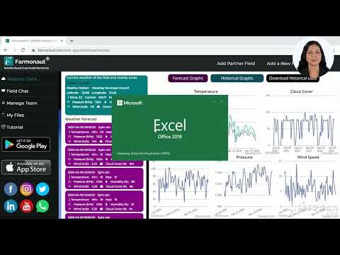
As demonstrated in the video above, farmers can now easily access and interpret weather data specific to their location. This level of detail allows for precise decision-making in areas such as:
- Planting and harvesting schedules
- Irrigation management
- Pest and disease control measures
Precision Farming Tools: Empowering Australian Farmers
The adoption of precision farming tools is rapidly increasing across Australia. These tools combine weather intelligence with on-farm data to create a comprehensive picture of farm operations.
- GPS-guided machinery for precise planting and harvesting
- Variable rate technology for optimized input application
- Soil moisture sensors for efficient water management
Farmers in regions like the Murray-Darling Basin are using these tools to navigate water scarcity issues, ensuring that every drop counts. The integration of weather data with precision farming tools allows for dynamic adjustments to irrigation schedules, maximizing water use efficiency.
Agricultural Weather Data: From Insight to Action
The true value of agricultural weather data lies in its ability to drive actionable insights. Modern farm management platforms are leveraging big data analytics to transform raw weather information into strategic recommendations.
- Predictive modeling for crop yield forecasts
- Risk assessment for weather-related crop damage
- Optimization of farm operations based on weather patterns
For instance, vineyard owners in South Australia’s Barossa Valley are using sophisticated weather data analytics to determine the optimal times for grape harvesting, ensuring the highest quality wine production.

The video above demonstrates how weather data can be seamlessly integrated into farm management systems, providing a comprehensive view of environmental conditions affecting crop growth.
Remote Sensing in Agriculture: Expanding Horizons
Remote sensing technology is pushing the boundaries of what’s possible in agriculture. By combining satellite imagery with data from drones and ground-based sensors, farmers can create a multi-layered view of their operations.
- Thermal imaging for detecting crop stress
- LiDAR technology for precise terrain mapping
- Hyperspectral imaging for detailed crop analysis
These advanced sensing techniques are particularly valuable in Australia’s diverse agricultural landscapes, from the vast cattle stations of the Northern Territory to the intensive horticultural operations in Victoria’s Goulburn Valley.
Climate Intelligence for Farmers: Adapting to a Changing World
As climate change continues to impact agricultural production, climate intelligence has become an essential tool for Australian farmers. This goes beyond short-term weather forecasting to include:
- Long-term climate trend analysis
- Scenario planning for different climate outcomes
- Adaptation strategies for shifting agricultural zones
Farmers in regions like Tasmania, where climate change is altering growing conditions, are using climate intelligence to explore new crop varieties and adjust their farming practices to ensure long-term sustainability.

Agricultural Data Analytics: Turning Information into Insight
The sheer volume of data available to modern farmers can be overwhelming. Agricultural data analytics platforms are essential for distilling this information into actionable insights.
- Machine learning algorithms for pattern recognition
- Predictive analytics for crop yield forecasting
- Benchmarking tools for performance comparison
These platforms are helping farmers across Australia to make data-driven decisions, from optimizing input use to predicting market trends.
Smart Farming Technology: The Future of Australian Agriculture
Smart farming technology is the culmination of all these advancements, creating interconnected farm ecosystems that operate with unprecedented efficiency.
- IoT sensors for real-time monitoring of farm conditions
- Automated irrigation systems responsive to weather forecasts
- AI-powered decision support systems for farm management
From the cotton fields of New South Wales to the sugar cane plantations of Queensland, smart farming technology is revolutionizing agricultural practices across Australia.

The video above showcases how satellite-based crop monitoring is being integrated into smart farming practices, providing farmers with unparalleled insights into their operations.
Agtech Weather Solutions: Tailored for Australian Conditions
Australia’s unique climate challenges require specialized agtech weather solutions. From managing tropical cyclones in the north to navigating drought conditions in the interior, these solutions are designed to address the specific needs of Australian farmers.
- Customized weather alerts for extreme events
- Drought forecasting and management tools
- Frost prediction systems for sensitive crops
These tailored solutions are helping farmers in every corner of the country to mitigate risks and maximize productivity.
“Australian farmers using agricultural weather data can reduce water usage by up to 30% while maintaining or improving crop productivity.”
Crop Yield Prediction: Harnessing the Power of Data
Accurate crop yield prediction is a game-changer for Australian agriculture. By combining historical data, current field conditions, and advanced weather forecasts, farmers can make informed decisions about planting, harvesting, and market strategies.
- Satellite-based vegetation index analysis
- Integration of soil moisture data and weather patterns
- Machine learning models for yield forecasting
This technology is particularly valuable in Australia’s grain-growing regions, where accurate yield predictions can influence national and global markets.
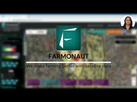
The Role of Farmonaut in Australian Agriculture
In the landscape of agricultural technology, Farmonaut stands out as a pioneering force. Their platform offers a comprehensive suite of tools that integrate satellite technology, AI, and blockchain to meet the diverse needs of modern agriculture.
- Real-time crop health monitoring using satellite imagery
- AI-driven farm advisory system for personalized insights
- Blockchain-based traceability for supply chain transparency
Farmonaut’s solutions are particularly relevant for Australian farmers looking to embrace precision agriculture without the high costs traditionally associated with such technologies.

By leveraging Farmonaut’s platform, Australian farmers can access advanced crop monitoring and weather intelligence tools, helping them make informed decisions and optimize their operations.
The video above demonstrates how Farmonaut’s technology can be used to generate time-lapse imagery of crop development, providing valuable insights into growth patterns and potential issues.
Comparative Analysis of Weather Intelligence Tools for Australian Agriculture
| Tool/Technology | Primary Function | Data Source | Accuracy (Estimated) | Best Suited For | Regions Most Applicable |
|---|---|---|---|---|---|
| Satellite Crop Monitoring | Vegetation health assessment, crop stress detection | Satellite imagery | 85-95% | Large-scale crop monitoring | All agricultural regions |
| Bureau of Meteorology Radar | Real-time precipitation tracking | Ground-based radar | 90-98% | Short-term weather forecasting | Coastal and high-population areas |
| Synoptic Charts | Large-scale weather pattern analysis | Multiple meteorological sources | 70-85% | Long-range weather prediction | All regions |
| Agricultural Data Analytics Platforms | Comprehensive farm data analysis and prediction | Multiple (satellite, IoT, historical data) | 80-90% | Precision agriculture, yield forecasting | Intensive farming regions |
| Precision Irrigation Systems | Water management optimization | Soil sensors, weather data | 90-95% | Water-efficient crop production | Arid and semi-arid regions |
Integrating Weather Intelligence into Farm Operations
The true power of weather intelligence lies in its integration with day-to-day farm operations. Australian farmers are increasingly adopting holistic approaches that combine various data sources and technologies.
- Integrating weather forecasts with irrigation scheduling
- Using climate data to inform crop rotation decisions
- Combining yield predictions with market analysis for strategic planning
This integrated approach is helping farmers across Australia to maximize efficiency and profitability while enhancing sustainability.
The Future of Weather Intelligence in Australian Agriculture
As we look to the future, the role of weather intelligence in Australian agriculture is set to expand even further. Emerging technologies and ongoing research promise to deliver even more precise and actionable insights.
- Integration of quantum computing for ultra-precise weather modeling
- Advanced AI systems for real-time decision support
- Expanded use of drones for hyper-local weather and crop monitoring
These advancements will further empower Australian farmers to navigate the challenges of climate change and market volatility, ensuring the continued strength and resilience of the agricultural sector.
Conclusion: Embracing the Agricultural Revolution
The revolution in Australian agriculture, driven by advanced satellite crop monitoring and weather intelligence, is well underway. From the tropical north to the temperate south, farmers are leveraging these powerful tools to boost productivity, enhance sustainability, and secure the future of food production.
As we’ve explored throughout this guide, the integration of weather forecasting for agriculture, precision farming tools, and agricultural data analytics is transforming the industry. The ability to make data-driven decisions based on real-time insights is giving Australian farmers a competitive edge in the global market.
We encourage all stakeholders in the agricultural sector to embrace these technologies and explore how they can be applied to their specific contexts. The future of farming is here, and it’s powered by intelligence, precision, and innovation.
Explore Farmonaut’s API for advanced agricultural data integration
Access Farmonaut’s API Developer Docs for detailed implementation guides


Farmonaut Subscriptions
Frequently Asked Questions
Q: How accurate is satellite crop monitoring?
A: Satellite crop monitoring can be extremely accurate, with many systems achieving accuracy rates of 85-95% for detecting crop health issues and predicting yields.
Q: Can small-scale farmers benefit from these advanced technologies?
A: Absolutely. Many providers, including Farmonaut, offer scalable solutions that are accessible and affordable for small-scale farmers.
Q: How often is satellite imagery updated for agricultural purposes?
A: The frequency of updates can vary, but many services provide updates every 3-5 days, with some offering daily revisits for certain areas.
Q: How can farmers integrate weather intelligence into their existing practices?
A: Farmers can start by using mobile apps and web platforms that provide localized weather forecasts and agronomic insights. Many of these tools can be easily integrated with existing farm management software.
Q: What role does the Bureau of Meteorology play in agricultural weather forecasting?
A: The Bureau of Meteorology provides essential baseline data and forecasts. Many agtech companies, including Farmonaut, build upon this data to provide more specialized agricultural insights.
By embracing these advanced technologies and insights, Australian farmers are well-positioned to lead the global agricultural sector into a more productive, sustainable, and resilient future.