Farmonaut® and STEi Foundation: Revolutionizing Agriculture in Anambra, Nigeria
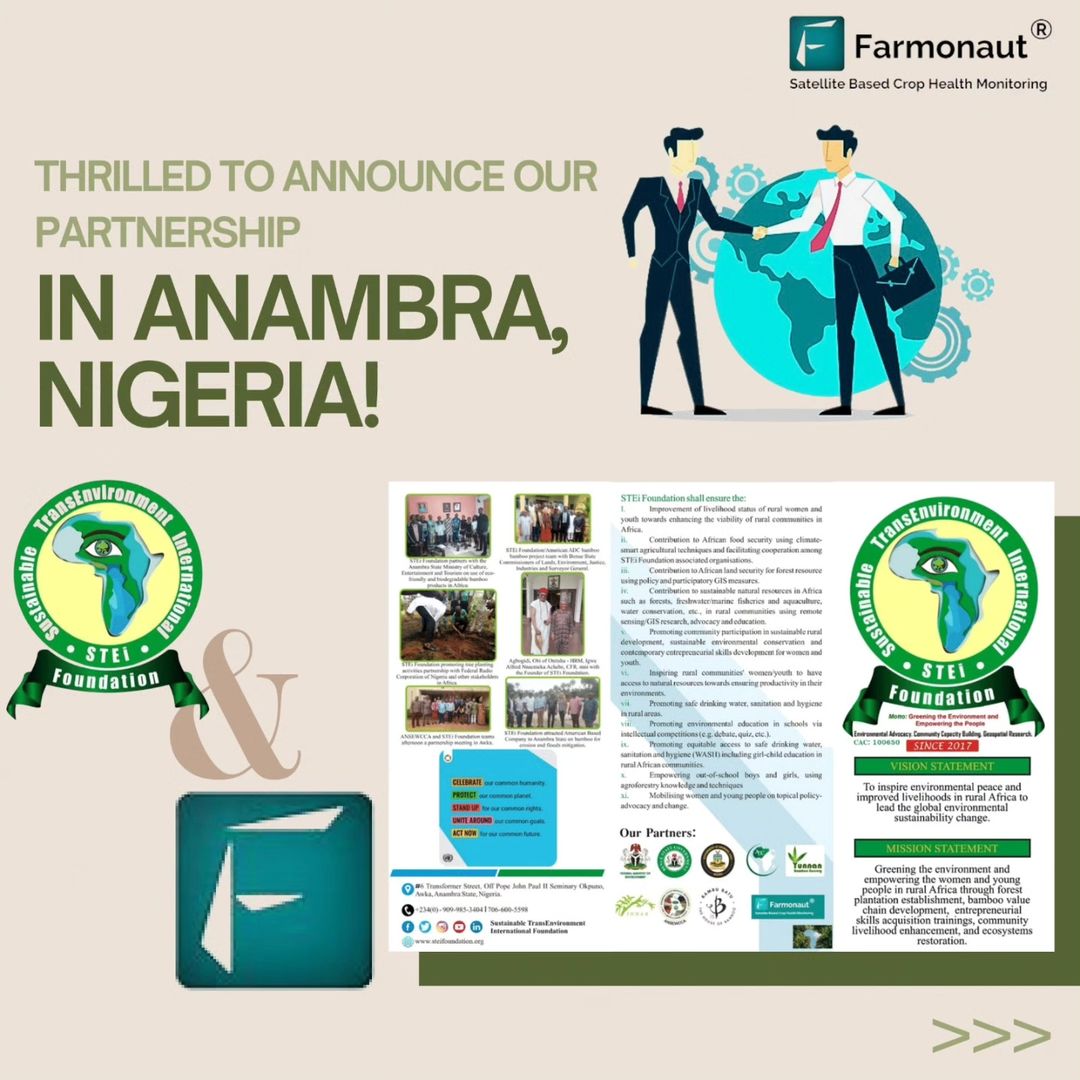
We are thrilled to announce a groundbreaking partnership between Farmonaut® and the STEi Foundation in Anambra, Nigeria. This collaboration marks a significant milestone in our ongoing efforts to transform agriculture and promote environmental sustainability in the region. By combining Farmonaut’s cutting-edge crop imaging technology with STEi Foundation’s local expertise, we are poised to make a lasting positive impact on the agricultural landscape of Anambra.
Our Collaborative Approach
At the heart of our partnership lies a shared commitment to leveraging advanced technologies and data-driven solutions to address critical challenges facing farmers and the environment in Anambra. Here’s an in-depth look at the key areas we’re focusing on:
1. Remote Sensing Technology
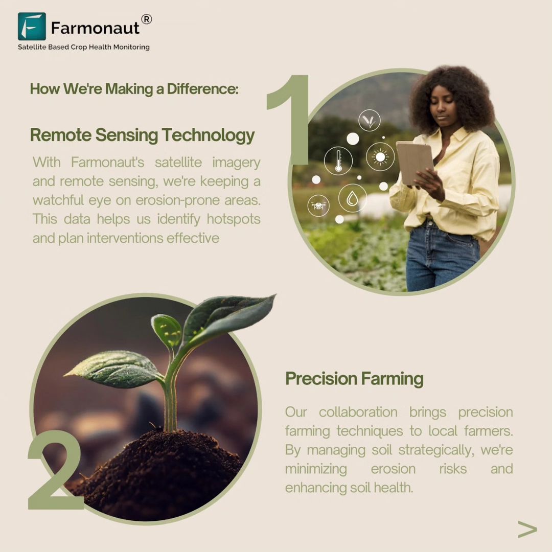
Farmonaut’s state-of-the-art satellite imagery and remote sensing capabilities are at the forefront of our collaborative efforts. We are harnessing these technologies to:
- Monitor erosion-prone areas with unprecedented accuracy
- Identify critical hotspots that require immediate intervention
- Plan and implement effective erosion control measures
- Track changes in land use and vegetation cover over time
Our remote sensing technology provides a bird’s-eye view of the entire region, allowing us to detect subtle changes in soil conditions, vegetation health, and land use patterns. This comprehensive overview enables us to make informed decisions and develop targeted strategies to combat erosion and promote sustainable land management practices.
2. Precision Farming
One of the cornerstones of our partnership is the introduction of advanced precision farming techniques to local farmers in Anambra. By leveraging Farmonaut’s satellite-based crop health monitoring system, we are empowering farmers with real-time data and insights to optimize their agricultural practices. Our precision farming approach includes:
- Soil health mapping and analysis
- Tailored fertilizer recommendations based on soil nutrient levels
- Precise irrigation scheduling to conserve water and prevent waterlogging
- Early detection of pest and disease outbreaks
- Yield prediction and harvest optimization
Through these precision farming techniques, we are not only minimizing erosion risks but also enhancing overall soil health for sustainable agriculture. By providing farmers with the tools and knowledge to make data-driven decisions, we’re helping them increase yields, reduce input costs, and adopt more environmentally friendly farming practices.
3. Resilient Crops
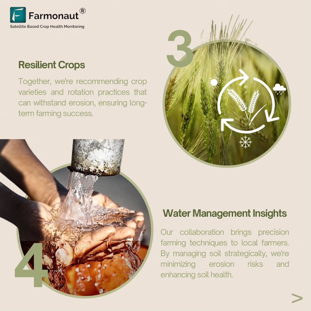
Our collaboration extends to recommending crop varieties and rotation practices that are specifically tailored to withstand erosion and thrive in the local climate. We are working closely with agricultural experts and local farmers to:
- Identify and promote drought-resistant crop varieties
- Develop optimal crop rotation schedules to maintain soil fertility
- Introduce cover crops to protect soil during fallow periods
- Encourage the adoption of agroforestry practices
- Provide guidance on intercropping for better land utilization
By focusing on resilient crops and sustainable farming practices, we aim to ensure long-term farming success and food security in the region. This approach not only helps farmers adapt to changing climate conditions but also contributes to the overall resilience of the agricultural sector in Anambra.
4. Water Management Insights
Effective water management is crucial for both erosion control and sustainable agriculture. Our partnership leverages Farmonaut’s advanced satellite technology to provide valuable water management insights to farmers and policymakers. These insights include:
- Real-time soil moisture monitoring
- Identification of areas prone to waterlogging or drought
- Optimization of irrigation schedules and techniques
- Mapping of watershed areas and natural water flows
- Recommendations for water conservation practices
By implementing precision farming techniques informed by these insights, we are helping farmers minimize erosion risks, conserve water resources, and promote overall soil health. This data-driven approach to water management is essential for sustainable agriculture in a region where water resources are often scarce and unpredictable.
5. Innovative Land Design
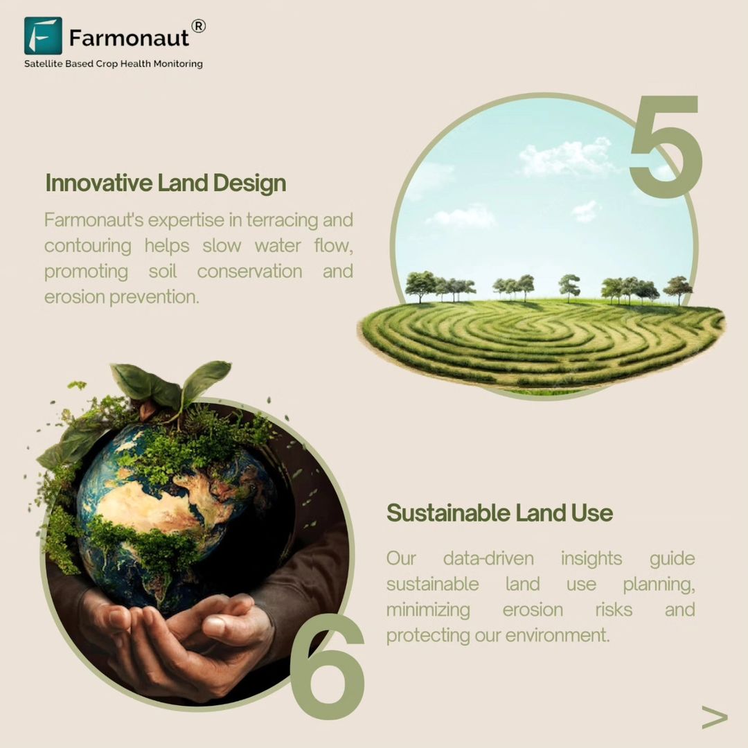
Farmonaut’s expertise in terracing and contouring techniques is playing a crucial role in our efforts to combat erosion and promote sustainable land use. Our innovative land design strategies include:
- Contour plowing to reduce water runoff and soil erosion
- Terracing of steep slopes to create level planting areas
- Implementation of grassed waterways to channel excess water safely
- Design and construction of retention ponds for water harvesting
- Integration of agroforestry systems to stabilize soil and provide additional income
These land design techniques are carefully tailored to the specific topography and soil conditions of Anambra. By slowing down water flow and promoting better water infiltration, we are not only preventing erosion but also improving soil moisture retention and overall agricultural productivity.
6. Sustainable Land Use Planning
Our partnership is committed to promoting sustainable land use practices that balance agricultural productivity with environmental conservation. Leveraging Farmonaut’s satellite data and AI-powered analytics, we are:
- Developing comprehensive land use maps for the region
- Identifying areas suitable for different types of agriculture
- Recommending crop zoning based on soil types and climate conditions
- Planning buffer zones to protect water bodies and sensitive ecosystems
- Monitoring land use changes to prevent deforestation and land degradation
By providing data-driven insights for sustainable land use planning, we are helping local authorities and farmers make informed decisions that reduce erosion risks, protect natural resources, and ensure the long-term viability of agriculture in Anambra.
The Power of Farmonaut’s Satellite-Based Crop Health Monitoring
At the core of our partnership’s success is Farmonaut’s advanced satellite-based crop health monitoring system. This innovative technology offers several advantages over traditional monitoring methods:
| Feature | Farmonaut Satellite System | Drone-based Monitoring | IoT-based Monitoring |
|---|---|---|---|
| Coverage Area | Large scale (regional to global) | Limited (local) | Very limited (field-level) |
| Frequency of Updates | Daily to weekly | As needed (requires manual flight) | Real-time, but localized |
| Cost-effectiveness | High (no on-site equipment needed) | Moderate (equipment and operator costs) | Low (high initial setup and maintenance costs) |
| Data Consistency | High (standardized imaging) | Moderate (affected by flight conditions) | Variable (depends on sensor quality and placement) |
| Ease of Use | High (cloud-based platform) | Moderate (requires trained operators) | Moderate (requires technical expertise) |
| Scalability | Highly scalable | Limited scalability | Moderately scalable |
Farmonaut’s satellite-based system offers unparalleled coverage, consistency, and cost-effectiveness, making it an ideal solution for large-scale agricultural monitoring and management in Anambra and beyond.
Empowering Farmers with Accessible Technology
We believe that the key to sustainable agriculture lies in empowering farmers with easy-to-use, affordable technology. That’s why we’ve made Farmonaut’s powerful tools accessible through various platforms:
- Web Application: Access Farmonaut’s full suite of tools through our web platform. Try it now.
- Mobile Apps: Download our user-friendly mobile apps for on-the-go farm management:
- API Access: For developers and businesses looking to integrate Farmonaut’s data into their own systems, we offer comprehensive API access. Explore our API.
For detailed documentation on our weather API and other developer resources, visit our Developer Docs.
Join the Agricultural Revolution
Our partnership with the STEi Foundation in Anambra is just the beginning. We invite farmers, agribusinesses, and agricultural organizations across Nigeria and beyond to join us in revolutionizing agriculture through technology. Subscribe to Farmonaut today and take the first step towards precision farming:
The Road Ahead
As we continue our collaboration with the STEi Foundation in Anambra, we are excited about the potential to expand our impact across Nigeria and beyond. Our partnership embodies a commitment to making a positive difference in agriculture, environmental conservation, and the lives of local farmers.
We envision a future where:
- Every farmer has access to cutting-edge agricultural technology
- Precision farming techniques are the norm, not the exception
- Sustainable land use practices are widely adopted
- Food security is strengthened through resilient and productive farming systems
- Environmental conservation goes hand-in-hand with agricultural development
Through our continued efforts and collaborations, we are confident that we can turn this vision into reality, creating a more sustainable and prosperous future for agriculture in Nigeria and around the world.
Frequently Asked Questions (FAQ)
- Q: How does Farmonaut’s satellite technology work?
A: Farmonaut uses multispectral satellite imagery to capture detailed information about crop health, soil moisture, and other key agricultural indicators. This data is then processed using advanced algorithms to provide actionable insights to farmers. - Q: Is Farmonaut’s technology suitable for small-scale farmers?
A: Yes, Farmonaut’s solutions are designed to be accessible and affordable for farmers of all scales, including small-scale farmers. Our mobile apps and user-friendly interface make it easy for anyone to benefit from precision farming techniques. - Q: How often is the satellite data updated?
A: Depending on the subscription plan, Farmonaut provides satellite data updates ranging from daily to weekly. This ensures that farmers have access to timely information for making crucial decisions. - Q: Can Farmonaut’s technology help with crop insurance claims?
A: Yes, Farmonaut’s satellite data can be used to verify crop conditions and yield estimates, which can be valuable for crop insurance claims and loan applications. - Q: How does Farmonaut contribute to sustainable farming practices?
A: By providing precise data on crop health, soil conditions, and water management, Farmonaut helps farmers optimize their use of resources, reduce waste, and implement more environmentally friendly farming practices.

For more information about our partnership with the STEi Foundation or to learn how Farmonaut can benefit your agricultural operations, please don’t hesitate to contact us:
- Website: www.farmonaut.com
- Phone: +91 6366026267
- Email: [email protected]
- YouTube:https://www.youtube.com/farmonaut
Join us in revolutionizing agriculture and creating a more sustainable future for farmers everywhere!