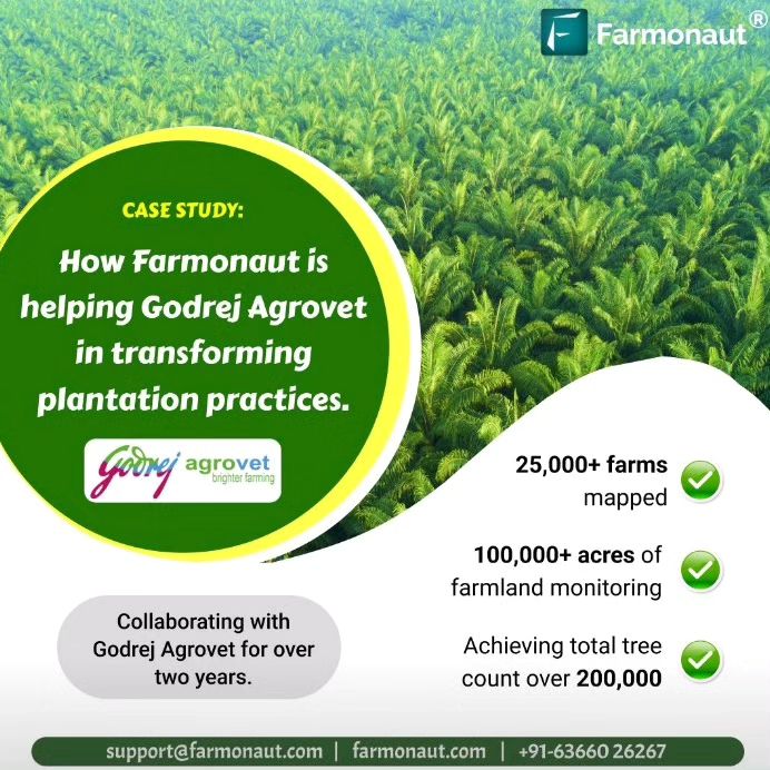
Transforming Plantation Practices: Farmonaut’s Collaboration with Godrej Agrovet
At Farmonaut, we’re excited to share the remarkable journey of our collaboration with Godrej Agrovet within two years. This partnership transformed plantation practices, leading to profound improvements in crop management and resource optimization. Together, we redefined the future of farming, integrating advanced technologies that reshaped the agricultural landscape.
In this comprehensive blog post, we reflect on our collective efforts, tracing the transformative impact of our AI-powered farm technologies and remote crop monitoring solutions. Through innovation and dedication, we created a lasting legacy in sustainable agriculture.
Table of Contents
- Introduction to the Farmonaut-Godrej Agrovet Collaboration
- Expanding Reach: Covering 100,000+ Acres Across Five States
- Continuous Monitoring of 25,000+ Farms
- AI-Powered Tree Counting: A Game-Changer in Plantation Management
- Farmonaut’s Flexible Platform: Tailored Insights for Godrej Agrovet
- The Power of Precision Farming in Modern Agriculture
- Farmonaut’s Satellite System vs. Drone and IoT-based Farm Monitoring
- Future Prospects and Continued Innovation
- FAQs
1. Introduction to the Farmonaut-Godrej Agrovet Collaboration
Farmonaut embarked on a groundbreaking partnership with Godrej Agrovet, one of India’s leading agribusiness companies. Our shared vision was to leverage cutting-edge technology to transform traditional plantation practices, making them more efficient, sustainable, and productive. This collaboration had since become a shining example of how precision farming can revolutionize the agricultural sector.
As pioneers in satellite-based farm analytics, we at Farmonaut brought our expertise in remote crop monitoring and AI-driven insights to the table. Godrej Agrovet, with its extensive network of farms and plantations, provided the perfect testing ground for our advanced technologies. Together, we set out to digitize vast tracts of agricultural land, implement AI-powered solutions, and provide data-driven insights to farmers and plantation managers.
2. Expanding Reach: Covering 100,000+ Acres Across Five States
One of the most significant achievements of our collaboration had been the extensive coverage we’ve achieved. Within two years, we’ve successfully digitized and monitored more than 100,000 acres of agricultural land. This massive undertaking spans five states in India:
- Andhra Pradesh
- Telangana
- Tamil Nadu
- Mizoram
- Orissa
This wide-ranging coverage had allowed us to gather invaluable data on various crop types, soil conditions, and climatic zones. By leveraging our satellite-based monitoring system, we had been able to provide Godrej Agrovet with a comprehensive view of their agricultural operations across these diverse regions.
The process of digitizing such vast areas involves several steps:
- Satellite Imagery Acquisition: We use high-resolution multispectral satellite imagery to capture detailed views of the agricultural lands.
- Data Processing: Our advanced algorithms process the raw satellite data to extract meaningful information about crop health, soil moisture, and other vital parameters.
- GIS Mapping: We create detailed Geographic Information System (GIS) maps of the farms, allowing for easy visualization and analysis of the data.
- Integration with Ground Data: We combine satellite data with ground-level information provided by Godrej Agrovet to enhance the accuracy of our insights.
This extensive digitization effort had laid the foundation for more informed decision-making and targeted interventions across Godrej Agrovet’s operations.
3. Continuous Monitoring of 25,000+ Farms
Beyond merely mapping the agricultural lands, our collaboration had once enabled the continuous monitoring of over 25,000 farms. This ongoing surveillance had become the foundation of our precision farming approach, offering real-time insights and timely interventions that transformed the farming landscape.
Here’s how our continuous monitoring system had benefited the farms:
- Early Detection of Issues: By consistently analyzing satellite imagery, we swiftly identified potential threats like pest infestations, disease outbreaks, or nutrient deficiencies before they spiraled out of control.
- Optimized Resource Allocation: Our system had illuminated the precise areas where resources such as water and fertilizers were most needed, ensuring the efficient use of these vital inputs.
- Yield Prediction: Through meticulous tracking of crop growth patterns over time, we provided accurate yield forecasts, empowering Godrej Agrovet in their strategic planning and logistics.
- Climate Adaptation: Continuous monitoring had allowed us to observe how different crops responded to shifting weather conditions, enabling more resilient climate adaptation strategies.
The impact of this constant vigilance had been profound. Farmers and plantation managers, armed with up-to-date information about their crops, were able to make data-driven decisions that led to higher yields and more sustainable farming practices.
4. AI-Powered Tree Counting: A Game-Changer in Plantation Management
One of the most innovative aspects of our collaboration with Godrej Agrovet had been the implementation of our AI-powered trees count app. This technology had revolutionized the way plantations are managed and inventoried.
Traditional methods of tree counting were labor-intensive, time-consuming, and prone to errors. Our AI solution had eliminated these challenges, providing Godrej Agrovet with precise tree distribution and health data. The results have been nothing short of impressive, with a total tree count exceeding 200,000!
Here’s how our AI-powered tree counting works:
- High-Resolution Imagery: We use very high-resolution satellite or drone imagery to capture detailed views of the plantations.
- AI Image Analysis: Our advanced machine learning algorithms analyze these images, identifying and counting individual trees.
- Species Classification: The AI can distinguish between different tree species, providing a breakdown of the plantation composition.
- Health Assessment: By analyzing the spectral signature of each tree, our system can also provide insights into tree health.
The benefits of this technology are manifold:
- Accurate Inventory: Plantation managers now have an exact count of trees, crucial for planning and reporting.
- Resource Optimization: Knowing the precise number and location of trees allows for more efficient allocation of resources like water and fertilizers.
- Growth Monitoring: Regular counts enable tracking of plantation growth and early detection of issues like tree loss.
- Time and Cost Savings: Automated counting saves significant time and labor costs compared to manual methods.
This technology had not only improved the efficiency of plantation management but had also opened up new possibilities for sustainable forestry and carbon sequestration projects.
5. Farmonaut’s Flexible Platform: Tailored Insights for Godrej Agrovet
At Farmonaut, we pride ourselves on the flexibility of our platform. This adaptability had been crucial in providing Godrej Agrovet with tailored insights that address their specific needs. Our collaboration had focused on three key areas:
- Tree Counting
- Tree Uprooting
- Tree Age Estimation
In each of these areas, we’ve achieved an outstanding accuracy rate of 85-95%. This high level of precision is a testament to the power of our AI algorithms and the quality of our satellite data.
Tree Counting
As mentioned earlier, our AI-powered tree counting had been a game-changer. For Godrej Agrovet, this means they can now:
- Accurately assess the size and composition of their plantations
- Track changes in tree populations over time
- Identify areas for new plantings or where trees may have been lost
Tree Uprooting Detection
Our platform can detect when trees have been uprooted, whether due to natural causes or human activity. This capability helps Godrej Agrovet:
- Quickly respond to instances of illegal logging or storm damage
- Maintain accurate inventories
- Plan replanting efforts more effectively
Tree Age Estimation
By analyzing satellite imagery over time and applying our AI algorithms, we can provide estimates of tree age. This information is valuable for:
- Predicting yield in fruit-bearing plantations
- Planning harvesting schedules in timber plantations
- Assessing the carbon sequestration potential of forested areas
The high accuracy of these insights (85-95%) means that Godrej Agrovet can rely on our data for critical decision-making processes. This level of confidence is crucial when managing large-scale agricultural operations.
6. The Power of Precision Farming in Modern Agriculture
Our collaboration with Godrej Agrovet exemplifies the transformative power of precision farming in modern agriculture. By leveraging advanced technologies like satellite imaging, AI, and big data analytics, we’re helping to usher in a new era of smart, sustainable, and highly efficient farming practices.
Key benefits of precision farming include:
- Resource Optimization: By providing detailed insights into crop health and soil conditions, precision farming allows for more targeted use of water, fertilizers, and pesticides. This not only reduces costs but also minimizes environmental impact.
- Increased Yields: With better monitoring and management, farmers can identify and address issues early, leading to healthier crops and higher yields.
- Risk Mitigation: Early detection of pest infestations, diseases, or adverse weather conditions allows for proactive measures to protect crops.
- Sustainability: Precision farming promotes more sustainable practices by reducing waste and optimizing resource use.
- Data-Driven Decision Making: Farmers and agribusinesses can make more informed decisions based on accurate, real-time data rather than guesswork or tradition.
Our work with Godrej Agrovet had demonstrated these benefits on a large scale, showing how precision farming can be effectively implemented across diverse geographical areas and crop types.
7. Farmonaut’s Satellite System vs. Drone and IoT-based Farm Monitoring
While there are various technologies available for farm monitoring, our satellite-based system offers unique advantages over drone and IoT-based solutions. Here’s a comparison:
| Feature | Farmonaut Satellite System | Drone-based Monitoring | IoT-based Monitoring |
|---|---|---|---|
| Coverage Area | Large (100,000+ acres easily) | Limited (Depends on flight time) | Limited (Depends on sensor placement) |
| Frequency of Data Collection | Regular (Every few days) | On-demand (Requires manual flights) | Continuous (But localized) |
| Cost Efficiency | High (No on-site equipment needed) | Medium (Requires drone and pilot) | Low (Requires many sensors and maintenance) |
| Data Consistency | High (Standardized imagery) | Medium (Varies with flight conditions) | High (But only for sensor locations) |
| Scalability | Excellent (Can easily add new areas) | Limited (Requires more drones/pilots) | Limited (Requires more sensors) |
| Weather Independence | Good (Some limitations in heavy cloud cover) | Poor (Cannot fly in bad weather) | Excellent (Operates in all weather) |
| Regulatory Compliance | Easy (No special permissions needed) | Challenging (Requires flight permits) | Moderate (May need permissions for towers) |
As the table shows, our satellite-based system offers unparalleled coverage, cost-efficiency, and scalability, making it the ideal choice for large-scale operations like those of Godrej Agrovet.
8. Future Prospects and Continued Innovation
The success of our collaboration with Godrej Agrovet had set the stage for continued innovation and expansion. Looking ahead, we at Farmonaut are committed to pushing the boundaries of what’s possible in agricultural technology. Some areas we’re exploring include:
- Enhanced AI Capabilities: We’re continually refining our AI algorithms to provide even more accurate and detailed insights.
- Integration with Other Data Sources: We’re looking at ways to integrate our satellite data with other sources like weather stations and soil sensors for even more comprehensive analysis.
- Predictive Analytics: Developing models that can predict crop yields, pest outbreaks, and optimal harvest times with even greater accuracy.
- Blockchain Integration: Exploring how blockchain technology can be used to enhance traceability and transparency in the agricultural supply chain.
- Climate Change Adaptation: Developing tools to help farmers adapt to changing climate conditions and extreme weather events.
We’re excited about the potential of these innovations to further transform agriculture, making it more sustainable, productive, and resilient in the face of global challenges.
9. FAQs
Q: How often is the satellite data updated?
A: Our satellite data is typically updated every 3-5 days, depending on the specific location and satellite coverage.
Q: Can Farmonaut’s technology be used for small farms?
A: Absolutely! While our collaboration with Godrej Agrovet demonstrates our capability to handle large-scale operations, our technology is scalable and can be used for farms of all sizes.
Q: How accurate is the AI-powered tree counting?
A: Our tree counting accuracy ranges from 85-95%, depending on factors like tree density and image resolution.
Q: Does Farmonaut provide mobile apps for farmers?
A: Yes, we offer mobile apps for both Android and iOS platforms. You can download them here:
Q: Can Farmonaut’s technology work in areas with frequent cloud cover?
A: While heavy cloud cover can sometimes interfere with satellite imaging, we use advanced algorithms and multiple satellite sources to minimize this issue and ensure consistent data availability.
Q: How can I access Farmonaut’s API for integration with my own systems?
A: We provide comprehensive API access for developers and businesses. You can find our API documentation here: Farmonaut API Docs
Conclusion
Our collaboration with Godrej Agrovet within two years had demonstrated the immense potential of combining advanced technology with agricultural expertise. By digitizing over 100,000 acres of farmland, continuously monitoring 25,000+ farms, and leveraging AI for precise tree counting and analysis, we’ve helped transform plantation practices and set new standards for efficiency and sustainability in agriculture.
At Farmonaut, we’re committed to continuing this journey of innovation and transformation. We invite farmers, agribusinesses, and technology enthusiasts to join us in shaping the future of agriculture. Whether you’re looking to optimize your farming operations or integrate our powerful APIs into your agritech solutions, we’re here to support you.
Ready to experience the power of Farmonaut? Try our platform today and see how our satellite-based solutions can revolutionize your approach to farming.
For developers interested in leveraging our technology, check out our API documentation.
Join us in our mission to make precision agriculture accessible to all and create a more sustainable, productive future for farming worldwide.