Revolutionizing Agriculture: Farmonaut’s Automated Crop Area Estimation
Have you ever wanted to perform crop area estimations at scale, but were deterred by long turnaround times and lack of visualization capabilities? At Farmonaut, we understand this challenge, and we’re excited to share how we’ve revolutionized the process of crop area estimation, making it super easy, quick, automated, and highly scalable!
The Power of Automated Crop Area Estimation
Our automated crop area estimation systems provide accurate and scalable solutions for various crops, including banana, rice, wheat, yellow corn, coriander, cotton, cumin, soybean, barley, sugarbeet, and many more. This innovative technology has already been successfully implemented by industry leaders such as SOPA, ITC Limited, Mulpuri Group, and Yaduka Agrotech, both in India and internationally.
But what exactly is crop area estimation, and why is it so crucial in modern agriculture? Let’s dive deeper into this topic and explore how Farmonaut is transforming the agricultural landscape.
Understanding Crop Area Estimation
Crop area estimation is the process of determining the total land area occupied by specific crops in a given region. This information is vital for various reasons:
- Agricultural planning and policy-making
- Yield forecasting
- Food security assessments
- Market analysis and price forecasting
- Resource allocation for farming inputs
- Environmental impact studies
Traditionally, crop area estimation has been a time-consuming and labor-intensive process, often relying on manual surveys and sampling methods. However, with the advent of satellite technology and advanced image processing techniques, we at Farmonaut have revolutionized this process.
Farmonaut’s Approach to Automated Crop Area Estimation
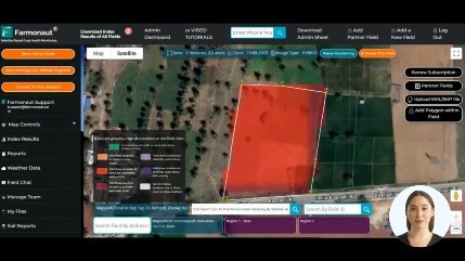
Our web platform for crop estimation leverages cutting-edge satellite technology, artificial intelligence, and machine learning algorithms to provide accurate crop estimation with unprecedented speed and efficiency. Here’s how our system works:
- Satellite Imagery Acquisition: We use high-resolution satellite imagery to capture vast agricultural areas.
- Image Processing: Our AI algorithms process these images to identify different crop types based on their unique spectral signatures.
- Machine Learning Classification: Advanced machine learning models classify the crops and delineate field boundaries.
- Area Calculation: The system automatically calculates the area occupied by each crop type.
- Visualization and Reporting: Results are presented through an intuitive web interface, complete with interactive maps and detailed reports.
Benefits of Farmonaut’s Automated Crop Area Estimation
Our system offers numerous advantages over traditional methods:
- Speed: Estimations that once took weeks or months can now be completed in a matter of hours or days.
- Accuracy: By eliminating human error and using high-resolution imagery, we achieve superior accuracy in our estimations.
- Scalability: Our system can easily handle large areas, from small farms to entire countries.
- Cost-effectiveness: Automated processes significantly reduce the need for manual labor and field visits.
- Real-time Updates: Regular satellite passes allow for frequent updates, providing near real-time data on crop areas.
- Accessibility: Our web-based platform allows users to access crop area estimates from anywhere with an internet connection.
Farmonaut vs. Traditional Methods: A Comparison
| Feature | Farmonaut Satellite System | Drone-based Monitoring | IoT-based Monitoring |
|---|---|---|---|
| Coverage Area | Global | Limited by flight range | Limited by sensor placement |
| Data Collection Frequency | Daily to weekly | As needed, weather-dependent | Continuous |
| Initial Setup Cost | Low | High | High |
| Maintenance | Minimal | Regular | Regular |
| Scalability | Highly scalable | Moderately scalable | Limited scalability |
| Data Processing | Automated | Semi-automated | Automated |
| Regulatory Compliance | No restrictions | Subject to aviation regulations | Generally unrestricted |
Applications of Automated Crop Area Estimation
Our scalable solutions for various crops have found applications across multiple sectors:
1. Government and Policy-making
Government agencies use our crop area estimation data to:
- Formulate agricultural policies
- Plan subsidy distributions
- Assess food security situations
- Monitor land use changes
2. Agribusiness and Supply Chain Management
Large agricultural companies leverage our data for:
- Supply and demand forecasting
- Optimizing procurement strategies
- Planning logistics and storage
3. Financial Services and Insurance
Banks and insurance companies utilize our estimations for:
- Risk assessment in agricultural lending
- Crop insurance policy formulation
- Claim verification
4. Research and Academia
Researchers and academic institutions use our data for:
- Studying crop patterns and rotations
- Analyzing the impact of climate change on agriculture
- Developing new agricultural models
The Future of Crop Area Estimation with Farmonaut
As we continue to innovate and improve our technology, we envision a future where:
- Real-time Monitoring: Crop area estimates are updated in near real-time, providing the most current information possible.
- Integration with IoT: Combining satellite data with ground-based IoT sensors for even more accurate and detailed crop information.
- AI-Powered Predictions: Advanced AI models that can predict crop areas before planting, based on historical data and current market trends.
- Blockchain Integration: Ensuring the transparency and traceability of crop area data through blockchain technology.
How to Get Started with Farmonaut’s Crop Area Estimation
Ready to revolutionize your approach to crop area estimation? Here’s how you can get started with Farmonaut:
- Sign Up: Visit our web platform and create an account.
- Define Your Area of Interest: Use our intuitive map interface to select the regions you want to monitor.
- Choose Your Crops: Select the specific crops you’re interested in estimating.
- Set Up Monitoring Frequency: Decide how often you want updates on your crop area estimates.
- Access Your Data: View your crop area estimates through our interactive dashboard, complete with visualizations and downloadable reports.
For developers and businesses looking to integrate our crop area estimation capabilities into their own systems, we offer a comprehensive API. Our API documentation provides all the information you need to get started.
Mobile Apps for On-the-Go Access
To make our crop area estimation data even more accessible, we’ve developed mobile apps for both Android and iOS platforms:
These apps allow you to access your crop area estimates, view maps, and receive notifications on-the-go, ensuring you’re always connected to your agricultural data.
Pricing and Subscription Options
We offer flexible pricing options to suit various needs and scales of operation. Choose the plan that best fits your requirements:
Frequently Asked Questions (FAQ)
Q: How accurate is Farmonaut’s crop area estimation?
A: Our crop area estimation is highly accurate, with typical accuracy rates exceeding 90%. The exact accuracy can vary depending on factors such as crop type, field size, and satellite imagery resolution.
Q: How often is the crop area data updated?
A: We offer updates ranging from daily to monthly, depending on your subscription plan and specific needs. Most users opt for weekly or bi-weekly updates for optimal balance between freshness of data and cost-effectiveness.
Q: Can Farmonaut estimate crop areas for any location in the world?
A: Yes, our satellite-based system can provide crop area estimates for virtually any location on Earth, subject to satellite coverage and cloud-free conditions.
Q: What’s the minimum field size that can be accurately estimated?
A: With our high-resolution satellite imagery, we can accurately estimate fields as small as 0.1 hectares (1000 square meters).
Q: How does Farmonaut’s system handle mixed cropping or intercropping?
A: Our advanced AI algorithms are trained to recognize mixed cropping patterns. While it’s more challenging than single-crop fields, we can provide reasonably accurate estimates for mixed cropping scenarios.
Q: Is historical data available for crop area estimates?
A: Yes, we maintain historical data, allowing users to track changes in crop areas over time. The availability of historical data may vary depending on the region and how long we’ve been monitoring it.
Q: Can I integrate Farmonaut’s crop area estimation data into my own systems?
A: Absolutely! We provide a comprehensive API that allows you to integrate our crop area estimation data directly into your own applications and systems.
Conclusion: Embracing the Future of Agriculture
At Farmonaut, we’re committed to revolutionizing agriculture through technology. Our automated crop area estimation system is just one example of how we’re making precision agriculture more accessible, efficient, and effective for farmers, agribusinesses, and policymakers worldwide.
By providing accurate, timely, and scalable crop area estimates, we’re empowering stakeholders across the agricultural value chain to make more informed decisions, optimize resource allocation, and ultimately contribute to global food security.
As we continue to innovate and expand our capabilities, we invite you to join us on this exciting journey. Whether you’re a small-scale farmer, a large agribusiness, or a government agency, Farmonaut has the tools and expertise to help you take your agricultural operations to the next level.
Ready to revolutionize your approach to crop area estimation? Sign up for Farmonaut today and experience the future of agriculture!
For any questions or to discuss your specific crop area estimation needs, don’t hesitate to reach out to us at [email protected]. Let’s work together to create a more efficient, productive, and sustainable agricultural future!