In today’s challenging agricultural landscape, farmers face complex management issues, low yields, and high costs. However, a groundbreaking solution has emerged to transform the farming experience: Farmonaut. This innovative platform leverages free agriculture satellite imagery and cutting-edge technology to simplify farming operations and boost productivity. Let’s explore how Farmonaut is revolutionizing the agriculture industry and why over 200,000 farmers worldwide trust this powerful tool.
The Power of Remote Sensing in Agriculture Market

The remote sensing in agriculture market has experienced significant growth in recent years, with satellite technology playing a crucial role in modernizing farming practices. Farmonaut harnesses this technology to provide farmers with invaluable insights and data-driven decision-making tools.
By utilizing free satellite imagery, Farmonaut offers a cost-effective solution for farmers to monitor their crops, analyze soil health, and optimize resource management. This approach not only reduces expenses but also increases efficiency by up to 30%, making it an indispensable tool for modern agriculture.
Effortless Field Management with Geotagging
One of Farmonaut’s standout features is its user-friendly geotagging capability. Farmers can easily add and manage their fields from the comfort of their homes, eliminating the need for time-consuming on-site visits. This streamlined process allows for efficient field management and better organization of agricultural operations.
- Geotag fields with precision
- Add multiple fields to your dashboard
- Manage all fields from one centralized platform
- Save time and resources on field visits
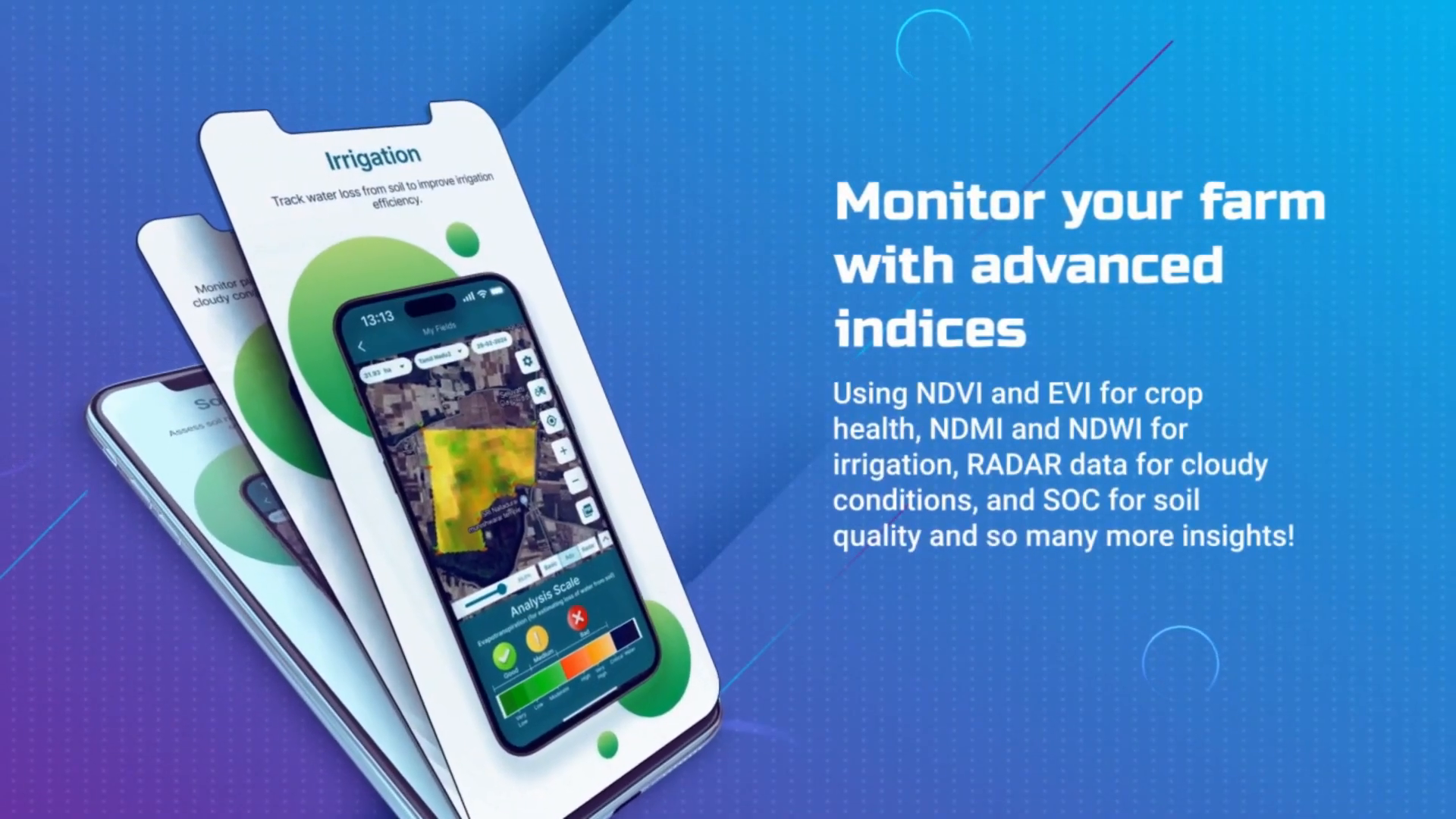
Advanced Farm Monitoring with Satellite Technology
Farmonaut’s agriculture real-time monitoring capabilities set it apart from traditional farming methods. By leveraging free agriculture satellite imagery, the platform provides farmers with a comprehensive view of their crops’ health and overall farm conditions.
Key Monitoring Features:
- Crop health assessment
- Irrigation monitoring
- Soil health analysis
- RADAR data for cloudy weather
These advanced indices enable farmers to make informed decisions about crop management, irrigation schedules, and soil treatments. The ability to access real-time data, even during adverse weather conditions, ensures that farmers can stay on top of their operations year-round.
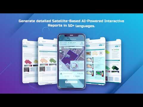
AI-Powered Reports: Transforming Data into Actionable Insights
Farmonaut takes the guesswork out of farming by generating detailed, satellite-based AI-powered interactive reports. These comprehensive reports provide farmers with valuable insights into their agricultural operations, helping them make data-driven decisions to optimize crop yield and resource allocation.
Report Features:
- Interactive and easy to understand
- Available in over 50 languages
- Customized to individual farm needs
- Regularly updated with latest satellite data
By leveraging the power of artificial intelligence and free agriculture satellite imagery, Farmonaut ensures that farmers have access to the most up-to-date and relevant information about their fields. This level of insight was previously only available to large-scale agricultural operations, but now it’s accessible to farmers of all sizes.
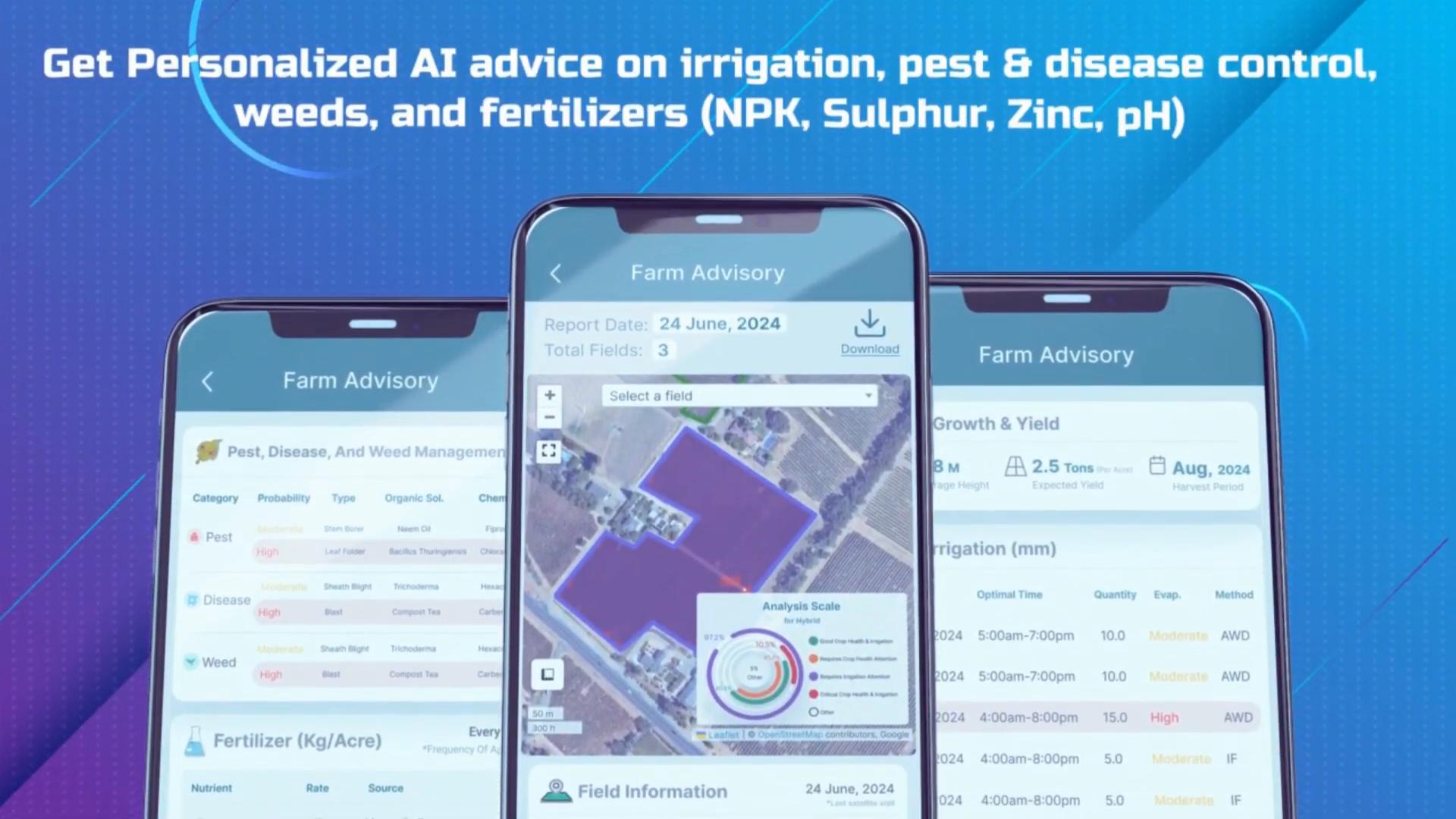
Personalized AI Advice for Optimal Farm Management
Farmonaut goes beyond just providing data – it offers personalized AI advice to help farmers make the best decisions for their specific needs. This feature acts as a virtual agricultural consultant, providing tailored recommendations on various aspects of farm management.
AI Advice Categories:
- Irrigation scheduling
- Pest and disease control
- Weed management
- Fertilizer application
By combining free agriculture satellite imagery with advanced AI algorithms, Farmonaut can identify potential issues before they become major problems. This proactive approach helps farmers prevent crop losses and optimize resource usage, leading to increased yields and reduced costs.
The Economic Impact of Farmonaut
Implementing Farmonaut’s technology can have a significant positive impact on a farm’s bottom line. By leveraging free agriculture satellite imagery and AI-driven insights, farmers can achieve substantial improvements in their operations.
| Metric | Improvement |
|---|---|
| Cost Reduction | 25% |
| Efficiency Increase | 30% |
These impressive figures demonstrate the transformative power of integrating satellite technology and AI into agricultural practices. By reducing costs and increasing efficiency, Farmonaut helps farmers improve their profitability and sustainability.
Applications of Satellite Technology in Agriculture
The applications of satellite technology in agriculture extend far beyond basic crop monitoring. Farmonaut harnesses the power of free agriculture satellite imagery to provide a wide range of benefits to farmers around the world.
Key Applications:
- Crop yield prediction
- Drought monitoring and management
- Precision agriculture
- Land use classification
- Climate change impact assessment
By utilizing these applications, farmers can make more informed decisions about planting, harvesting, and resource allocation. This data-driven approach leads to more sustainable farming practices and improved food security on a global scale.
The Rise of Automated Pest Monitoring Systems
One of the most promising developments in the agriculture sector is the growth of the automated pest monitoring system market. Farmonaut integrates this technology with free agriculture satellite imagery to provide farmers with a comprehensive pest management solution.
Benefits of Automated Pest Monitoring:
- Early detection of pest infestations
- Reduced pesticide use
- Improved crop quality
- Lower labor costs
By combining satellite data with on-the-ground sensors and AI analysis, Farmonaut can alert farmers to potential pest issues before they become widespread. This proactive approach not only saves crops but also promotes more environmentally friendly farming practices.
Leveraging Free Satellite Imagery for Global Agriculture
The availability of free satellite imagery has been a game-changer for the agricultural industry. Farmonaut takes full advantage of this resource, providing farmers with access to high-quality satellite data without the hefty price tag typically associated with such technology.
Sources of Free Satellite Imagery:
- Sentinel-2 (European Space Agency)
- Landsat (NASA/USGS)
- MODIS (NASA)
By utilizing these free satellite resources, Farmonaut democratizes access to advanced agricultural technology. This approach allows small-scale farmers and large agricultural operations alike to benefit from satellite-based insights and improve their farming practices.