
🚀 Introduction to Farm Visualization with Satellite Data
In the rapidly evolving world of agriculture technology, web app creation for agriculture technology is becoming increasingly crucial. One of the most powerful tools in this domain is the ability to visualize farms using satellite data. This blog post will delve into the intricacies of using iFrames for API integration to visualize farm data, a game-changing approach for agriculture technology industry web app design.
The integration of satellite image APIs and weather APIs into web applications is revolutionizing how we understand and manage agricultural lands. By leveraging these technologies, web app design agencies for the agriculture technology industry are creating solutions that provide unprecedented insights into farm health, crop conditions, and environmental factors.
🔑 Understanding API Keys and Field IDs in Agriculture Tech
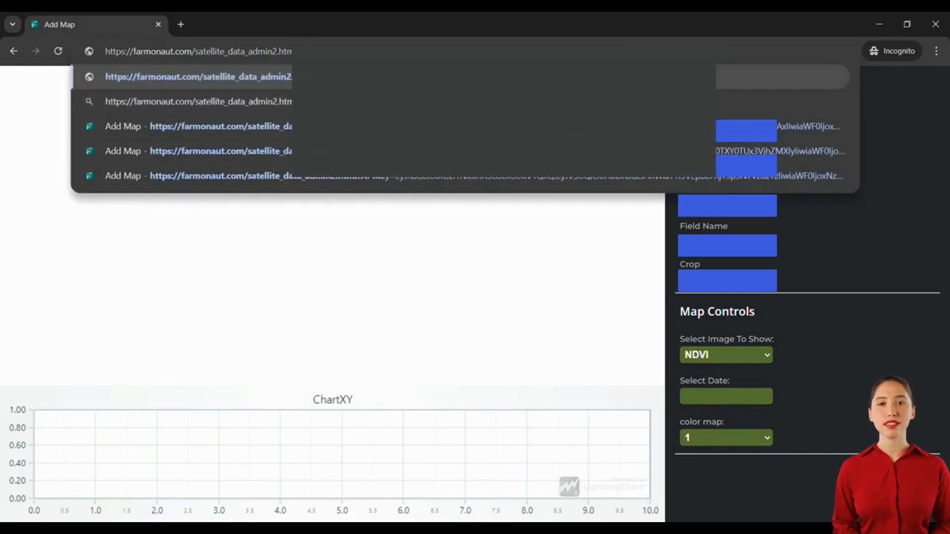
To begin your journey in web app creation for agriculture technology using satellite data visualization, you’ll need to familiarize yourself with two crucial elements: API keys and field IDs. These components are fundamental to accessing and utilizing the power of satellite imagery in your agricultural web applications.
API Keys: Your Digital Access Pass
An API key is essentially a unique identifier for your account. It’s the key that unlocks access to the wealth of satellite data and visualization tools. For those engaged in agriculture technology industry web app design, it’s important to note that the API key required for iFrame usage differs from the one used for general integration.
Field IDs: Pinpointing Your Focus
Each agricultural field you want to visualize needs a unique identifier, known as the field ID. This allows your web application to fetch and display data specific to individual fields, enabling precise analysis and monitoring.
🖼️ Exploring Image Types in Agricultural Satellite Data
When it comes to web app creation for agriculture technology, understanding different image types is crucial. Two of the most commonly used types in agricultural satellite imagery are NDVI (Normalized Difference Vegetation Index) and NDWI (Normalized Difference Water Index).
NDVI: Gauging Plant Health
NDVI is the default image type in many agriculture technology web apps. It provides valuable insights into vegetation health and density, making it an essential tool for crop monitoring and yield prediction.
NDWI: Assessing Water Content
NDWI is crucial for understanding the water content in vegetation and soil. This information is vital for irrigation management and drought monitoring in agricultural settings.
📊 Visualizing Field Information in Agriculture Tech Web Apps
A well-designed agriculture technology industry web app should provide comprehensive field information at a glance. This includes crucial data points that give users a complete picture of the farm they’re analyzing.
| Information Type | Description |
|---|---|
| Farmer Name | Identifies the owner or manager of the field |
| Farmer Phone | Contact information for quick communication |
| Field Area | Size of the agricultural land |
| Field Name | Unique identifier for the specific plot |
| Crop Type | Current cultivation in the field |
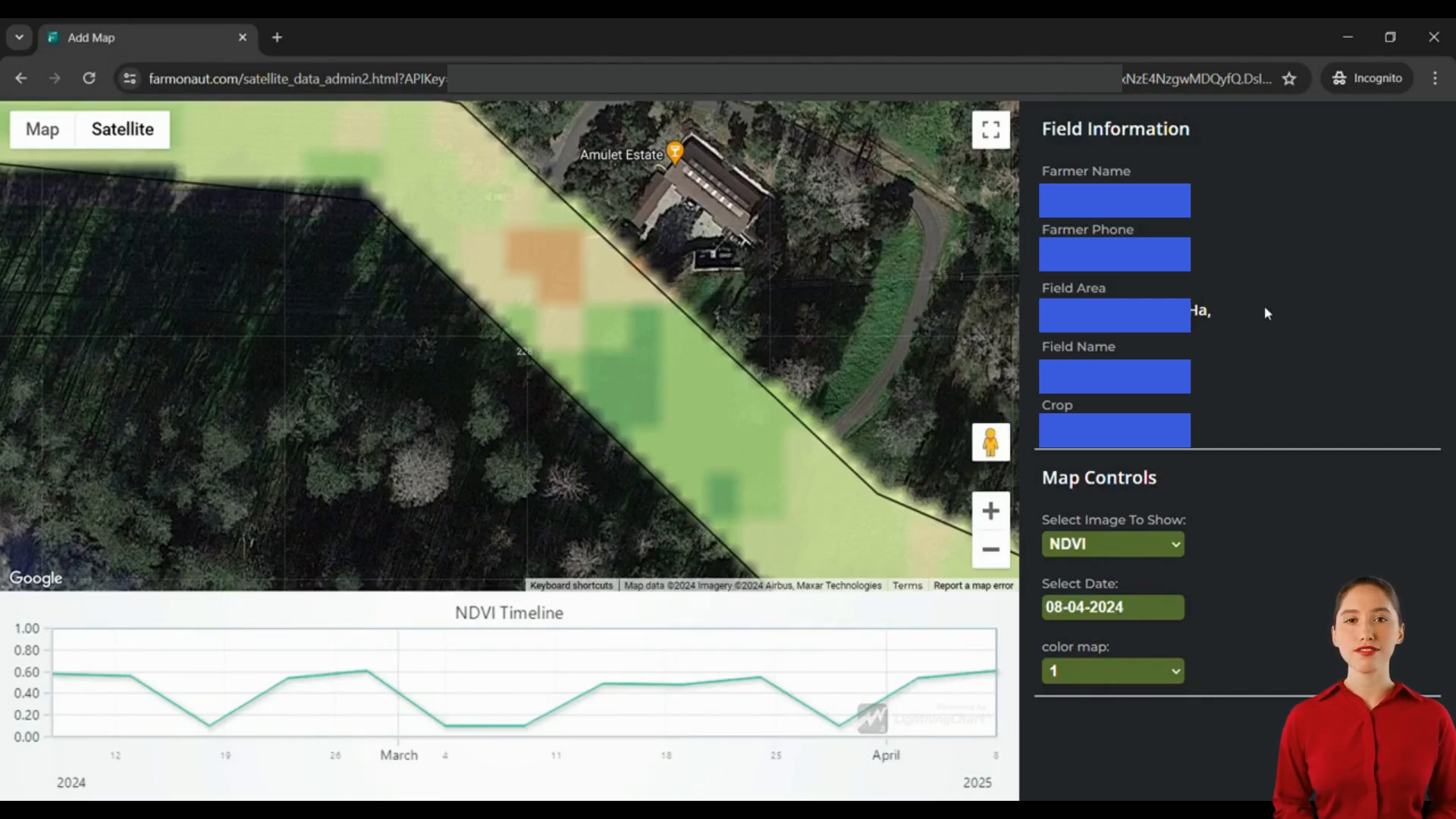
🎨 Leveraging Color Maps in Agricultural Data Visualization
Color maps play a crucial role in web app creation for agriculture technology, especially when it comes to interpreting satellite imagery. They provide a visual representation of different data types, making complex information easily digestible for users.
Adapting to Image Types
As you switch between different image types (like NDVI and NDWI), the color representation changes to convey different types of information effectively. This dynamic visualization is a key feature in advanced agriculture technology industry web app design.
Adjusting Visual Intensity
Many web app design agencies for the agriculture technology industry incorporate features that allow users to alter the color map. This adjustment can change the visual intensity of the image, helping to highlight specific aspects of the data.
📈 Utilizing Timeline Charts in Agricultural Web Apps
Timeline charts are an essential feature in web app creation for agriculture technology. They provide a historical perspective on field conditions, allowing users to track changes over time.
Plotting Index Values
These charts plot the index values (such as NDVI or NDWI) at different satellite visit dates. This feature is invaluable for monitoring crop health trends, identifying potential issues early, and making data-driven decisions.
Comparative Analysis
Advanced agriculture technology industry web app designs often allow users to overlay multiple indices on the same timeline. This enables comparative analysis, providing deeper insights into the interplay between different agricultural factors.
🌐 Integrating Weather APIs in Agricultural Web Apps
While satellite imagery provides crucial data about crop health and field conditions, integrating weather APIs can take your web app creation for agriculture technology to the next level. Weather data adds another layer of valuable information for farmers and agricultural managers.
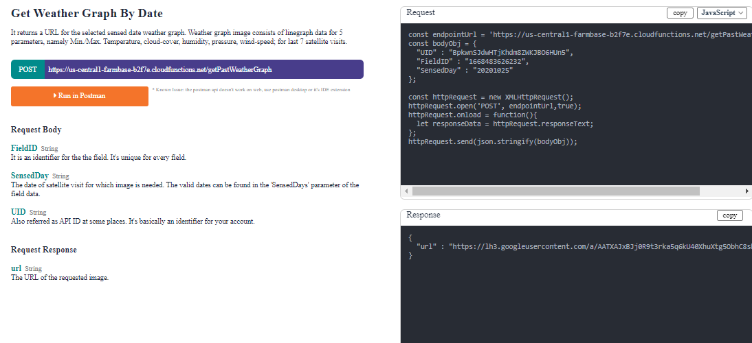
Real-time Weather Information
By incorporating a weather API, your web app can provide real-time weather information specific to each field location. This includes current conditions, short-term forecasts, and historical weather data.
Weather-based Insights
Combining weather data with satellite imagery allows for more comprehensive analysis. For example, changes in NDVI can be correlated with recent rainfall or temperature patterns, providing deeper insights into crop health and potential yield.
🔧 Best Practices for Agriculture Technology Web App Design
When engaging in web app creation for agriculture technology, there are several best practices that agriculture technology industry web app firms should keep in mind:
- Prioritize user-friendly interfaces
- Ensure mobile responsiveness
- Implement robust data security measures
- Provide clear, actionable insights
- Offer customization options for users
- Integrate with other farm management tools
- Regularly update with new features and data sources
❓ FAQ: Web App Creation for Agriculture Technology
Q: What is the importance of satellite imagery in agriculture technology?
A: Satellite imagery provides valuable insights into crop health, field conditions, and environmental factors, enabling data-driven decision-making in agriculture.
Q: How can weather APIs enhance agricultural web apps?
A: Weather APIs provide real-time and forecast data that can be correlated with satellite imagery to offer more comprehensive insights into field conditions and potential crop outcomes.
Q: What are the key features of a good agriculture technology web app?
A: Key features include satellite image visualization, weather data integration, field information display, timeline charts for historical analysis, and user-friendly interfaces.
Q: How often is satellite data updated in these web apps?
A: The frequency of updates depends on the satellite data provider, but many services offer updates every few days to weekly.
Q: Can these web apps be used for precision agriculture?
A: Yes, these apps are excellent tools for precision agriculture, allowing farmers to make targeted decisions based on specific field conditions.
🔮 The Future of Web App Creation for Agriculture Technology
As we look to the future, web app creation for agriculture technology is poised for even more exciting developments. The integration of artificial intelligence and machine learning algorithms promises to deliver even more accurate predictions and insights.
Agriculture technology industry web app firms are also exploring the potential of augmented reality (AR) and virtual reality (VR) to provide immersive experiences for farm planning and management. These advancements will further revolutionize how we interact with and understand agricultural data.
In conclusion, the field of web app creation for agriculture technology is rapidly evolving, offering unprecedented opportunities for farmers, agronomists, and agricultural businesses. By leveraging satellite imagery, weather data, and advanced visualization techniques, these web apps are transforming the way we approach farming in the 21st century. As technology continues to advance, we can expect even more innovative solutions that will help address global food security challenges and promote sustainable agricultural practices.