Revolutionizing Agriculture: The Power of Satellite-Based Crop Monitoring
In the ever-evolving world of agriculture, staying ahead of the curve is crucial for success. At Farmonaut, we’re excited to share how crop monitoring has reached new heights in modern agriculture, thanks to advanced technologies like NDVI, EVI, and NDRE satellite images. Our web app platform is empowering agri-businesses, research organizations, and individual farmers with comprehensive crop monitoring throughout all growth stages.
The Evolution of Crop Monitoring
Traditional farming methods relied heavily on manual observation and intuition. While these techniques have served us well for centuries, the increasing demands of global food production and the challenges posed by climate change necessitate a more precise and data-driven approach. This is where satellite-based crop monitoring comes into play, offering a revolutionary way to manage and optimize agricultural practices.
Understanding NDVI, EVI, and NDRE
Before we dive deeper into the benefits of satellite-based crop monitoring, let’s break down the key technologies that make it possible:
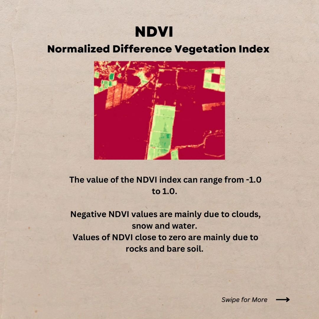
- NDVI (Normalized Difference Vegetation Index): This is a simple but powerful indicator of plant health. NDVI measures the difference between near-infrared light (which healthy vegetation strongly reflects) and red light (which vegetation absorbs). The resulting values range from -1 to 1, with higher values indicating healthier vegetation.
- EVI (Enhanced Vegetation Index): Similar to NDVI, EVI is designed to enhance the vegetation signal with improved sensitivity in high biomass regions. It also reduces atmospheric influences and canopy background signals.
- NDRE (Normalized Difference Red Edge): This index is particularly useful for assessing crop health in later growth stages. It’s more sensitive to changes in chlorophyll content and can provide valuable insights into crop maturity and potential yield.
The Power of Satellite Imagery in Agriculture
Satellite imagery has transformed the way we approach agriculture. Here’s how:
- Wide Coverage: Satellites can capture images of vast areas in a single pass, making it possible to monitor large farms or even entire regions efficiently.
- Frequent Updates: Depending on the satellite constellation, we can obtain new images every few days, allowing for near real-time monitoring of crop health and development.
- Non-Invasive: Unlike ground-based methods, satellite monitoring doesn’t require physical presence in the field, reducing the risk of crop damage and saving time.
- Historical Data: Satellite imagery provides a historical record of field conditions, enabling long-term trend analysis and informed decision-making.
Farmonaut’s Approach to Crop Monitoring
At Farmonaut, we’ve harnessed the power of satellite technology to provide comprehensive crop monitoring solutions. Our platform integrates NDVI, EVI, and NDRE data to give farmers and agricultural professionals a complete picture of crop health throughout the growing season.
Early Growth Stage Monitoring
During the critical early growth stages, our platform utilizes NDVI and EVI indices to provide valuable insights:
- Quick stress detection: Identify areas of crop stress before they become visible to the naked eye.
- Disease identification: Spot potential disease outbreaks early, allowing for targeted treatment.
- Nutrient deficiency detection: Pinpoint areas that may require additional fertilization.
These early insights allow farmers to make informed decisions shortly after planting, potentially saving entire crops from failure.
Later Growth Stage Monitoring
As crops mature, our NDRE imaging comes into play, offering:
- Detailed crop health assessment: Get a more nuanced view of crop vigor and potential yield.
- Maturity tracking: Monitor crop development to optimize harvest timing.
- Late-stage disease identification: Detect issues that could impact final yields.
- Irrigation deficiency spotting: Identify areas that may need additional water to maximize yield.
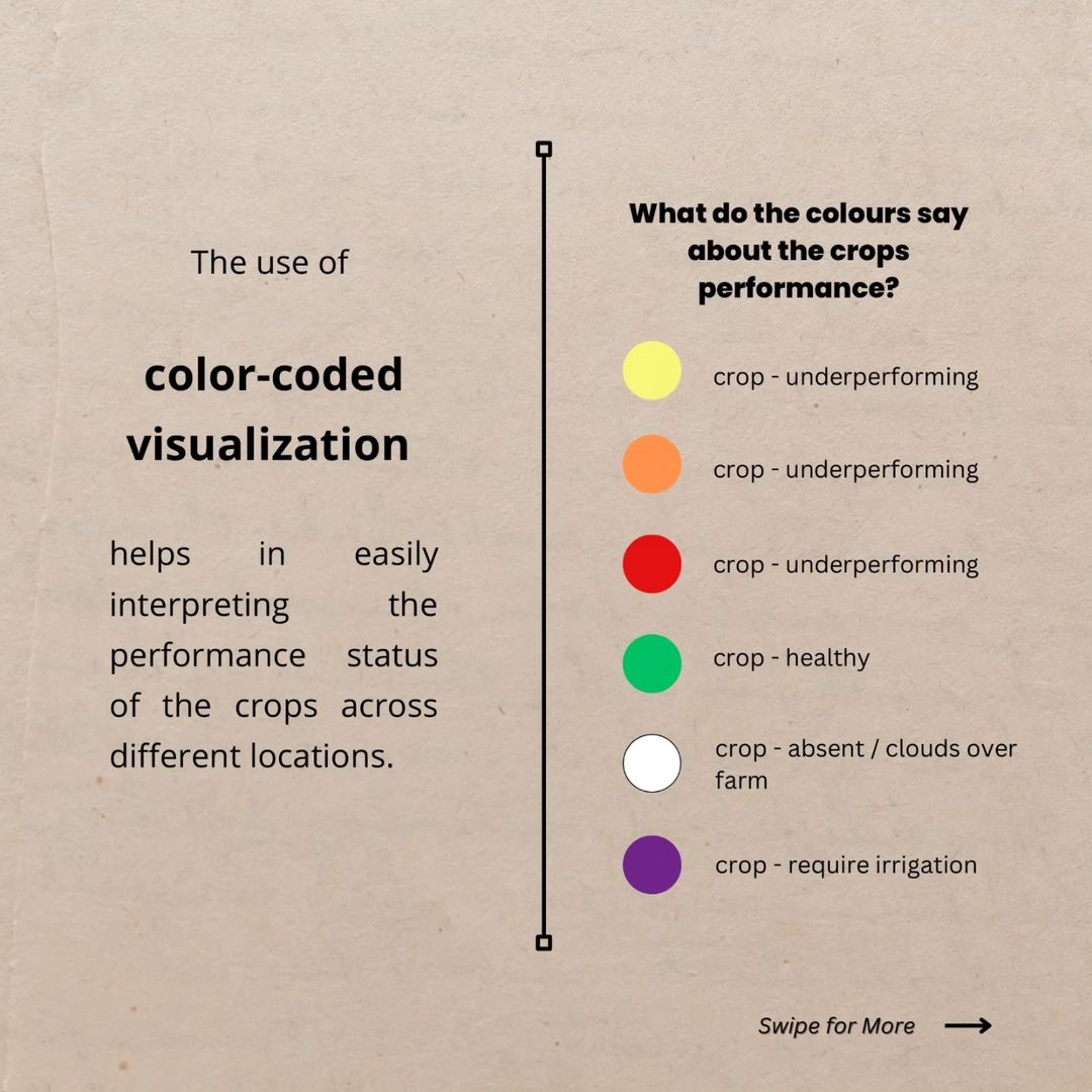
The Benefits of Color-Coded Visualization
One of the key features of our platform is the use of color-coded visualization to represent crop performance. This intuitive system allows farmers to quickly interpret the status of their crops across different locations:
- Red: Indicates severely underperforming crops that require immediate attention.
- Orange: Represents underperforming crops that need intervention.
- Yellow: Shows slightly underperforming crops that should be monitored closely.
- Green: Indicates healthy crops performing as expected.
- Blue: Represents areas where crops are absent or obscured by clouds.
- Purple: Indicates areas that may require irrigation.
This color-coding system enables farmers to prioritize their efforts and resources, focusing on areas that need the most attention.
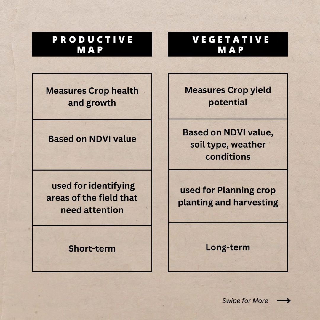
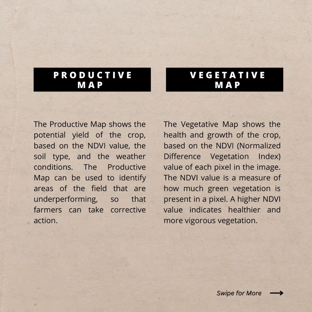
Productive vs. Vegetative Maps
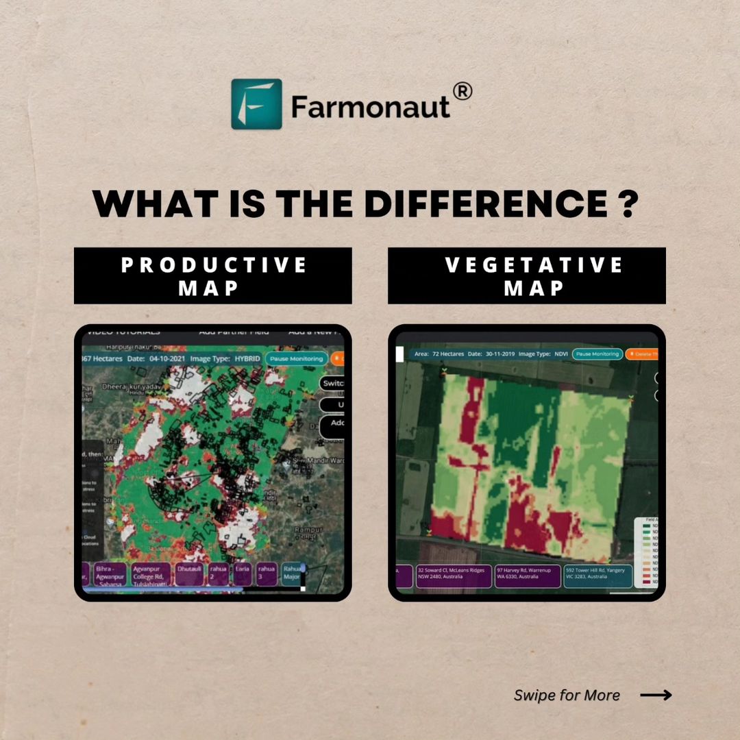
Our platform offers two types of maps that provide complementary information:
Productive Map
- Measures crop yield potential
- Based on NDVI value, soil type, and weather conditions
- Used for planning crop planting and harvesting
- Provides long-term insights
Vegetative Map
- Measures crop health and growth
- Based on NDVI value
- Used for identifying areas of the field that need immediate attention
- Provides short-term insights
By utilizing both maps, farmers can make informed decisions about both immediate actions and long-term planning.
The Advantages of Farmonaut’s Satellite System
While drone and IoT-based farm monitoring systems have their merits, Farmonaut’s satellite-based approach offers several distinct advantages:
| Feature | Farmonaut Satellite System | Drone-based Monitoring | IoT-based Monitoring |
|---|---|---|---|
| Coverage Area | Large scale (hundreds to thousands of hectares) | Medium scale (tens to hundreds of hectares) | Small scale (limited by sensor placement) |
| Frequency of Updates | Every few days (depending on satellite pass) | As needed (requires manual flights) | Continuous (but limited to sensor locations) |
| Initial Investment | Low (subscription-based) | High (drone purchase, training) | Medium to High (sensor network setup) |
| Operational Complexity | Low (cloud-based platform) | High (requires skilled operator) | Medium (maintenance of sensor network) |
| Weather Dependency | Moderate (can see through light cloud cover) | High (cannot operate in poor weather) | Low (continuous operation) |
| Historical Data Analysis | Extensive (years of satellite data available) | Limited (depends on flight frequency) | Extensive (continuous data collection) |
Implementing Precision Agriculture with Farmonaut
Precision agriculture is at the heart of what we do at Farmonaut. Our platform puts the power of data-driven decision-making at your fingertips, allowing you to optimize crop management and boost productivity throughout the entire growth journey. Here’s how you can implement precision agriculture using our tools:
- Field Mapping: Start by mapping your fields in our web app. This provides the baseline for all future monitoring and analysis.
- Regular Monitoring: Our satellite imagery is updated frequently, allowing you to keep a close eye on crop development. Make it a habit to check your fields regularly through our platform.
- Interpret the Data: Use our color-coded maps and detailed analytics to understand the state of your crops. Look for patterns and anomalies that might indicate issues or opportunities.
- Targeted Interventions: Based on the insights from our platform, implement targeted interventions. This might include selective irrigation, localized fertilizer application, or pest control measures in specific areas.
- Track Progress: Use our historical data features to track the effectiveness of your interventions over time. This allows you to refine your strategies and continuously improve your farming practices.
- Plan for the Future: Utilize our predictive analytics to make informed decisions about crop rotation, planting times, and resource allocation for future seasons.
Farmonaut’s Commitment to Sustainable Agriculture
At Farmonaut, we believe that precision agriculture is not just about increasing yields – it’s also about promoting sustainable farming practices. By providing detailed insights into crop health and resource needs, our platform helps farmers:
- Reduce water usage through targeted irrigation
- Minimize chemical inputs by applying fertilizers and pesticides only where needed
- Decrease fuel consumption by optimizing field operations
- Improve soil health through data-driven crop rotation and management practices
These practices not only benefit the environment but also help farmers reduce costs and improve long-term productivity.
The Future of Crop Monitoring
As technology continues to advance, we at Farmonaut are committed to staying at the forefront of agricultural innovation. We’re constantly exploring new ways to integrate emerging technologies into our platform, including:
- AI and machine learning for even more accurate predictions and recommendations
- Integration with IoT devices for ground-truth data validation
- Advanced weather modeling for improved crop yield forecasting
- Blockchain technology for enhanced traceability in the food supply chain
By continually innovating and improving our services, we aim to empower farmers and agricultural professionals with the tools they need to meet the challenges of 21st-century agriculture.
Getting Started with Farmonaut
Ready to revolutionize your approach to crop management? Getting started with Farmonaut is easy:
- Visit our web app to create an account.
- Download our mobile app for Android or iOS to access your data on the go.
- Map your fields and start receiving satellite-based insights within days.
- Explore our API documentation if you’re interested in integrating our data into your own systems.
For developers and businesses looking to leverage our satellite and weather data, check out our comprehensive API documentation.
Pricing Plans
We offer flexible pricing plans to suit farms and businesses of all sizes. Choose the plan that best fits your needs:
Frequently Asked Questions
Q: How often are satellite images updated?
A: The frequency of updates depends on the satellite constellation and your subscription plan. Typically, we provide new images every 3-5 days, weather permitting.
Q: Can satellite imagery see through clouds?
A: While thick cloud cover can obstruct optical satellite imagery, our platform uses multiple data sources and advanced algorithms to provide the most accurate information possible, even in cloudy conditions.
Q: Is Farmonaut suitable for small farms?
A: Absolutely! We offer plans suitable for farms of all sizes, from small family operations to large commercial enterprises.
Q: How accurate is satellite-based crop monitoring?
A: Satellite-based monitoring has proven to be highly accurate, often detecting issues before they’re visible to the naked eye. However, we always recommend ground-truthing for critical decisions.
Q: Can Farmonaut integrate with my existing farm management software?
A: Yes, our API allows for integration with many popular farm management systems. Contact our support team for more information on specific integrations.
Conclusion
The future of agriculture is here, and it’s powered by satellite technology. At Farmonaut, we’re proud to be at the forefront of this agricultural revolution, providing farmers and agribusinesses with the tools they need to optimize crop management, boost productivity, and promote sustainable farming practices.
By harnessing the power of NDVI, EVI, and NDRE satellite images, we’re making precision agriculture accessible to farms of all sizes. From early detection of crop stress to optimizing harvest timing, our comprehensive crop monitoring solutions are transforming the way we approach farming.
Join us in embracing the future of agriculture. Visit Farmonaut today to learn more about how our satellite-based crop monitoring can revolutionize your farming practices.
Follow us on Instagram and YouTube for the latest updates and agricultural insights. For any questions or support, don’t hesitate to reach out to us at [email protected] or call +91 6366026267.
Together, let’s cultivate a smarter, more sustainable future for agriculture!