
7 Insane Agricultural Geospatial Technology Hacks for Yields
“Geospatial tech can boost crop yields by up to 20% through precision mapping and targeted resource application.”
Introduction: The Power of Geospatial Technology in Agriculture
In our modern world, geospatial technology in agriculture is transforming the way we grow food, manage resources, and conquer global farming challenges. Guided by satellite imagery, GIS agriculture tools, remote sensing, and AI-driven platforms like Farmonaut, farmers now have the unrivaled ability to collect, analyze, and act upon data with precision at every step—from soil preparation to harvesting and beyond.
As we strive to improve yields and promote sustainable farming practices, these geospatial innovations empower us to monitor crops, manage soil and irrigation, predict yield, detect issues rapidly, and integrate sustainability into every process. Let’s explore seven insane technology hacks—backed by data, real-world application, and the spirit of innovation—that are revolutionizing agriculture.

Hack 1: Precision Agriculture – Transforming Farm Management
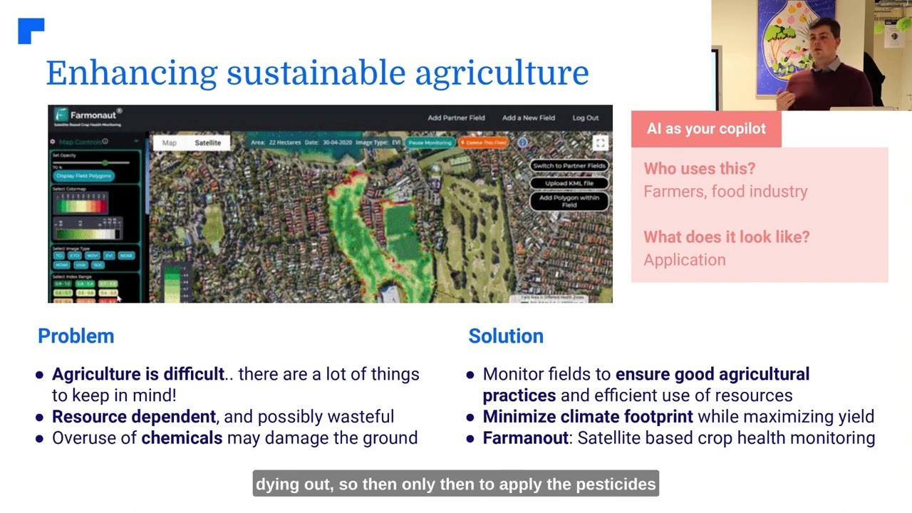
At the core of agricultural geospatial innovation lies precision agriculture. This transformative approach empowers us to collect, analyze, and act upon spatial and temporal data across every stage of the farming cycle. By leveraging GPS-guided machinery, Variable Rate Technology (VRT), and diagnostics from satellite data, we can optimize planting, fertilizing, and harvesting for each unique section of our fields.
- Data-Driven Management: Real-time spatial information helps us make specific, data-driven decisions—minimizing waste, reducing input costs, and enhancing yields.
- VRT Optimization: VRT enables us to tailor the application of fertilizers, pesticides, and water at varying rates according to exact crop needs, preventing overuse and minimizing environmental impact.
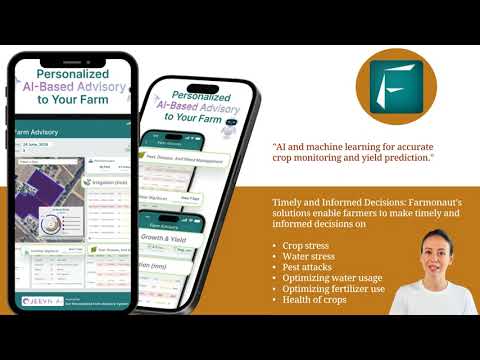
- Farmonaut Advantage: With platforms like Farmonaut, precision agriculture is accessible and affordable. Its android, iOS, web, and API solutions offer real-time crop health monitoring, actionable insights, and advisory support for all farm sizes.
The results? Increased productivity, cost savings, and measurable sustainability. By deploying precision management, we tap into one of the most potent geospatial technology hacks for maximizing agricultural yields.

Hack 2: Crop Monitoring and Yield Prediction with Satellite Imagery
Effective crop monitoring and yield prediction allow us to anticipate issues and optimize field operations long before traditional methods would detect concerns. Utilizing satellite imagery for farming, advanced drones, and remote sensors, geospatial technology provides a continuous stream of real-time, high-resolution data:
- Remote Sensing in Agriculture: Platforms like Farmonaut make remote crop health monitoring simple, employing NDVI (Normalized Difference Vegetation Index), soil moisture readings, and vegetation trend analysis for timely decision-making.
- Multi-Source Data Analysis: Integration of weather data, historical yield patterns, and soil conditions leads to highly accurate yield prediction models.
- Proactive Response: Early detection of nutrient deficiencies, pest infestations, and diseases enables us to intervene faster and more precisely—saving resources, reducing crop loss, and boosting yields.
Platforms like Farmonaut not only monitor crops but also analyze agricultural data using AI-powered advisory tools such as its Jeevn AI. Through personalized farm insights and weather forecasts, we can maximize yield and efficiency with actionable data.
“Over 60% of large farms worldwide now use satellite imagery for real-time crop monitoring and management.”
Hack 3: Soil and Irrigation Management for Smart Resource Use
The foundation of healthy, high-yielding fields is proactive soil and irrigation management. By harnessing geospatial data, we can map soil types, track moisture levels, and optimize irrigation—ensuring crops thrive while conserving water.
- Geospatial Soil Mapping: GIS agriculture tools let us see the spatial distribution of nutrients, texture, and pH across fields. This supports strategic crop selection, fertilizer planning, and enhances long-term soil health.
- Efficient Irrigation Schedules: By integrating weather patterns, moisture data, and remote sensing in agriculture, we can design irrigation systems that meet plants’ real needs—reducing both water consumption and runoff.
- Farmonaut’s Edge: With carbon footprint tracking and advanced soil analysis, Farmonaut enables us to monitor real-time emissions while fine-tuning resource application—driving both sustainability and profitability.

Hack 4: Pest and Disease Management with GIS and Remote Sensing
Outbreaks of pest and disease can devastate yields if left unchecked. Geospatial technologies empower us to detect and act against pest and disease threats swiftly:
- Remote Sensing for Infestation Mapping: Satellite imagery and drone surveys help pinpoint zones of crop stress or abnormal patterns, indicating pest or disease activity.
- Timely, Precise Interventions: With geospatial data, we receive dynamic warnings and management recommendations tailored to the specific location and scale of the outbreak.
- Farmonaut Solution: Farmonaut’s AI-based crop monitoring delivers real-time alerts and provides expert guidance on pest and disease control, saving both your crop and the environment by reducing unnecessary chemical usage.
This advanced integration not only helps to substantially reduce crop loss but also minimizes the use of chemical pesticides—supporting sustainable farming practices and higher profitability.
Hack 5: Livestock Monitoring – Insights from the Field
Geospatial technology in agriculture extends far beyond plants—it’s now pivotal in livestock management. By equipping herds with GPS trackers and analyzing spatial data via GIS agriculture tools, we unlock new levels of efficiency, health, and safety:
- Real-Time Location Tracking: Instantly identify livestock location and movement patterns, lowering risks of loss or theft and improving pasture rotation planning.
- Health and Nutritional Monitoring: Platforms like Farmonaut provide actionable data on livestock health, fertility cycles, and growth patterns—enabling us to intervene proactively.
- Fleet Management Efficiency: For agribusinesses, Farmonaut’s fleet and resource management tools bring added precision, lower operational costs, and superior safety for moving assets, machinery, and staff in large operations.
With precision data and mapping, we create a safer, more productive environment for both livestock and farm workers—driving value throughout our agricultural management.
Hack 6: Agroforestry – Mapping Trees for a Sustainable Future
Agroforestry—the synergy of trees, crops, and livestock in a single land system—is a powerful method for sustainable agriculture. Geospatial innovation empowers us to map, plan, and optimize agroforestry layouts with unprecedented accuracy:
- Remote Mapping of Tree Cover: Using multispectral satellite data and remote sensing in agriculture, we can chart tree species distribution, health, growth rates, and carbon sequestration potential.
- Sustainability & Policy Planning: GIS-based analysis supports regulatory compliance, long-term environmental stewardship, and targeted climate action strategies in both farming and forestry contexts.
- Farmonaut Plantation Advisory: With Plantation and Forest Advisory Services, Farmonaut streamlines agroforestry decision-making and resource allocation from planting to maturity.
Integrating spatial tree cover data helps us improve soil health, reduce emissions, support wildlife habitat, and future-proof our farming against ecological shocks.
Hack 7: Agricultural Supply Chain Optimization via Location Intelligence
Beyond the boundaries of the farm, geospatial location intelligence is transforming agricultural supply chain optimization from field to consumer:
- End-to-End Traceability: Blockchain integration—like Farmonaut’s product traceability solution—offers real-time, tamper-proof tracking of agricultural products for added transparency and trust.
- Logistics & Routing Optimization: By analyzing location, production, and demand patterns, we minimize transport time, fuel usage, and emissions while ensuring supply consistency and safety.
- Risk & Compliance Management: Satellite and GPS-based verification streamlines crop loan and insurance approvals, reduces fraudulent claims, and increases access to farm financing options.
- Farmonaut’s Large-Scale Platform: For agribusinesses and institutional managers, Farmonaut’s Large Scale Farm Management app brings advanced, scalable management of vast farm blocks and supply routing—all via a user-friendly web or mobile experience.
Smarter supply chain management reduces costs, increases profitability, and promotes consumer confidence through transparent data from farm to fork.
Comparative Feature-Impact Table: 7 Agricultural Geospatial Technology Hacks
| Technology Hack Name | Primary Function | Estimated Yield Improvement (%) | Implementation Complexity | Sustainability Impact (Estimated Resource Savings) |
|---|---|---|---|---|
| Precision Agriculture | Optimized input/output management with GPS & VRT | 10-25% | Medium | Up to 20% reduced water and chemical usage |
| Crop Monitoring & Yield Prediction | Remote analysis of crop health and forecasting | 10-20% | Low-Medium | Reduced input waste, optimized harvest timing |
| Soil & Irrigation Management | Spatial mapping of soil/moisture for targeted irrigation | 8-18% | Medium | 30%+ water conservation |
| Pest & Disease Management | Early detection and precision intervention | 5-15% | Low | 15%+ reduction in pesticide/herbicide use |
| Livestock Monitoring | GPS/GIS-based animal tracking & health | 5-12% | Medium | Improved grazing, feed efficiency |
| Agroforestry | Tree mapping, carbon tracking, land planning | 8-20% | Low-Medium | Greater biodiversity, improved carbon sequestration |
| Supply Chain Optimization | Logistics & product traceability with blockchain/GIS | 9-16% | Medium | Lower fuel use, reduced spoilage and loss |
Farmonaut’s Cutting-Edge Geospatial Suite
Farmonaut is leading the global charge in making precision agriculture accessible and affordable for every farmer, agribusiness, and institution. By fusing satellite imagery, AI, GIS, and blockchain, Farmonaut’s platform offers:
- Real-time Crop Health Monitoring via multispectral imagery and AI analytics
- Personalized Advisory Systems for tailored management decisions and yield improvements
- Blockchain Traceability for secure, transparent product tracking through the supply chain
- Fleet and Resource Management tools for optimizing machinery and operational costs
- Carbon Footprinting—Measure and reduce greenhouse emissions from your farming activities in real-time using precise data.
- Large Scale Management—with scalable farm administration tools fit for institutions and big farms.
Accessible as a web, Android, or iOS app, and via API, this technology suite ensures every segment of agriculture can increase productivity, profitability, and sustainability—no matter where we farm or how large our operation is.
Whether we’re an individual farmer, cooperative, agricultural enterprise, or institutional leader, Farmonaut’s value proposition lies in democratizing access to the very latest in geospatial, remote sensing, and blockchain-enabled management.
The benefits are clear: reduced operational costs, higher yields, less waste, increased transparency, stronger sustainability, and improved access to farm financing solutions.
Challenges and the Future of Agricultural Geospatial Technology
Despite rapid advances, adoption of geospatial tools in agriculture is not without challenges:
- Initial Costs: While prices are falling, high-tech sensors or frequent imagery can be expensive for smallholders. Farmonaut’s use of subscription models and scalable options lowers this barrier.
- Technical Learning Curve: Mastering GIS systems and interpreting geospatial data requires new skills. User-friendly platforms, educational content, and AI-powered analytics now make these tools far more accessible.
- Data Management Complexity: Agricultural data can quickly become overwhelming. Modern apps like Farmonaut automate data sorting, generate actionable alerts, and integrate historical and real-time streams for clarity and ease of use.
- Future Opportunities: The integration of AI, machine learning, low-cost drones, and expanded satellite coverage will further accelerate value delivery. Accessibility and precision for all global farming communities are set to rise as these technologies mature.
As climate challenges mount and food demands rise, the future is bright for data-driven agriculture—where geospatial technologies, sustainability, and yields go hand in hand.
FAQs on Agricultural Geospatial Technology
What is geospatial technology in agriculture?
Geospatial technology in agriculture refers to systems and methodologies—such as GIS, remote sensing, satellite imagery, and GPS—that collect, analyze, and help us use spatial data to manage crops, soil, resources, and operations more efficiently.
How does precision agriculture improve crop yields?
Precision agriculture uses GPS, variable rate inputs, and geospatial analytics to target resources (fertilizers, water, pesticides) where and when they are needed most. This minimizes waste, cuts costs, and can boost yields by 10–25% compared to uniform management.
What role does satellite imagery play in farming?
Satellite imagery for farming provides real-time, wide-area data on crop health, growth patterns, moisture, and potential pest or disease risks. This enhances monitoring, yield prediction, and intervention timing, all of which drive smarter, more sustainable farming.
How can I access advanced geospatial agriculture tools?
Farmonaut offers accessible, subscription-based solutions via web, Android, iOS apps, and APIs. This enables everyone—from smallholder farmers to institutional managers—to harness satellite monitoring, AI advice, and more.
Are these technologies only for large farms?
No! Modern geospatial solutions like those from Farmonaut are designed for scalability, serving individual smallholder farms just as effectively as massive agribusinesses or governmental programs.
How do geospatial technologies promote sustainability?
By targeting resource application, reducing chemical runoff, conserving water, and enabling carbon tracking, these tools minimize environmental impact while increasing food production. Platforms like Farmonaut’s carbon footprinting allow us to actively manage emissions and encourage sustainable best practices.
Can geospatial data help with farm supply chain transparency?
Absolutely. Solutions such as Farmonaut’s blockchain-based product traceability guarantee the location, safety, and authenticity of goods throughout the agricultural supply chain.
Conclusion: Advancing Agricultural Yields Sustainably with Geospatial Hacks
Geospatial technology in agriculture stands at the forefront of a paradigm shift—combining the power of spatial data, real-time monitoring, AI-driven management, and blockchain capabilities to build a smarter, more sustainable, and more profitable future for farming and forestry worldwide.
By embracing the seven insane geospatial technology hacks outlined above, we not only increase yields and efficiency but also pave the way for better environmental stewardship, lower costs, and a resilient food supply chain. With affordable, accessible solutions like Farmonaut, the power to transform agriculture is in all of our hands.
Step into the new era: With the click of a button, access cutting-edge geospatial agriculture tools—monitor your crops, save water, reduce emissions, and enhance your farm’s long-term profitability.


Discover Farmonaut’s full suite of geospatial farming solutions today—and build the future of agriculture, rooted in data, sustainability, and growth!


