
- Introduction: The Revolution of Remote Sensing in Agriculture
- Understanding Remote Sensing in Agriculture
- 7 Shocking Yield Secrets Unveiled by Remote Sensing
- Key Technologies: Satellite Imagery, Drones & More
- Comparison Table: Remote Sensing Technologies and Their Impact
- Farmonaut: Bridging Tradition and Innovation in Agriculture
- Major Benefits of Remote Sensing in Agriculture
- Challenges, Considerations & The Future of Farming
- Farmonaut Subscriptions and Access
- FAQ: Remote Sensing in Agriculture
- Conclusion: Cultivating the Future With Remote Sensing
“Remote sensing can detect crop stress up to 10 days before visible symptoms appear, boosting early intervention accuracy.”
Remote Sensing in Agriculture: 7 Shocking Yield Secrets
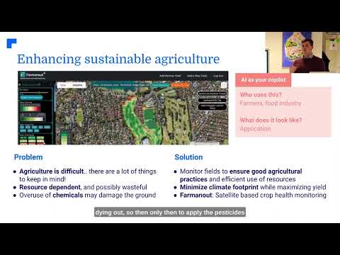
In today’s age of technological innovation, the agricultural landscape has been revolutionized by remote sensing and the power of satellite imagery and drones. These advancements are providing unprecedented opportunities in crop health monitoring, soil moisture management, precision agriculture technology, and sustainable practices.
As we witness a transformative shift from traditional methods to highly data-driven systems, let’s delve deeper into the game-changing secrets revealed by remote sensing in agriculture. By integrating innovative technologies and informed decisions, farmers, agribusinesses, and foresters are able to optimize resources, enhance yields, and secure our planet’s future through environmental sustainability.


Understanding Remote Sensing in Agriculture
At its core, remote sensing is the process of collecting information about objects or areas from a distance, using sensor-based technologies such as satellites, drones, and other aerial platforms. Traditionally used in meteorology and military applications, its integration with agriculture has revolutionized farm management, forestry, and resource optimization.
By seamlessly capturing and analyzing data related to soil moisture, crop health, land use, climate variables, and vegetation indices, we gain crucial insights for monitoring crops, managing resources, and improving productivity. Remote sensing provides clarity and accuracy that are simply not possible through manual, on-ground methods.
When we combine satellite imagery for farming, drones in agriculture, and advanced analytical systems, we unlock the potential to optimize agricultural practices, minimize waste and risk, and drive sustainable yields.
- Monitoring vast areas without the need for extensive field visits
- Enabling early detection of crop diseases, pest infestations, and environmental stresses
- Assisting with effective water use through soil moisture monitoring
- Supporting precision agriculture technology by providing site-specific, actionable recommendations
- Reducing overall costs and increasing profitability for farmers and agribusinesses
“Over 80% of precision agriculture users rely on satellite imagery for real-time crop health monitoring and yield prediction.”
7 Shocking Yield Secrets Unveiled by Remote Sensing in Agriculture
Over the last decade, our reliance on remote sensing in agriculture has shed light on critical yield secrets—changing how we approach farming, decision-making, and long-term sustainability. Let’s reveal these powerful applications that drive higher yields, more reliable crop outcomes, and smarter resource management.
1. Crop Health Monitoring: The Power of NDVI Crop Analysis
Early and accurate crop health monitoring is the cornerstone of successful farming. Using indices like the Normalized Difference Vegetation Index (NDVI), we track vegetation vitality down to each pixel. Healthy crops reflect light differently compared to stressed or diseased crops—these NDVI values typically range from -1 (no vegetation) to 1 (healthy, dense vegetation).
- Detecting nutrient deficiencies, diseases, and pest infestations far sooner than the eye can see (early intervention is a proven yield booster!)
- Identifying variations within fields, enabling targeted interventions and precise treatment
- Supporting optimized fertilizer application, reducing waste and environmental impact
This accurate, data-driven approach minimizes the risk of surprises during the growing season and maximizes output.
Try Farmonaut’s satellite-based crop health monitoring here for real-time, actionable field analysis.
2. Soil Moisture Monitoring & Efficient Irrigation Management
Soil moisture monitoring delivers vital insights into a key determinant of crop growth—water availability. Remote sensors assess moisture levels at soil and canopy layers by detecting radiation signatures and reflectance from satellites and drones.
- Enables precision irrigation: apply the right amount of water at the right time
- Helps reduce water waste and ensure crops receive adequate hydration
- Supports site-specific water management practices, improving resource allocation
Discover how large-scale farm management is simplified through advanced remote sensing platforms.

3. Precision Agriculture Technology: Integrating GIS & GPS
Modern precision agriculture technology leverages remote sensing data with Geographic Information Systems (GIS) and Global Positioning Systems (GPS)—enabling granular, site-specific field management:
- Variable-rate application of fertilizers, pesticides, and other inputs based on real-time data
- Improving accuracy, decreasing input costs, and reducing environmental impact
- Mapping soil variability, crop stress zones, and other crucial parameters for tailored interventions
Farmonaut’s technology offers fleet management and resource optimization tools to keep large and small operations running at peak efficiency.
4. Yield Prediction and Estimation Systems
By leveraging historical and real-time remote sensing data, sophisticated models can predict crop yields with remarkable accuracy. These estimates benefit a wide array of stakeholders:
- Farmers and agribusinesses can forecast harvest quantities for better financial planning
- Supply chain and logistics companies optimize transport, storage, and market access
- Governmental agencies improve subsidy, insurance, and food security planning
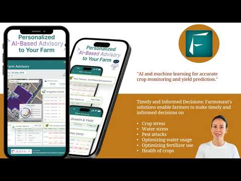
Platforms like Farmonaut employ AI-driven advisory systems (Jeevn AI) to deliver such analytics, helping users optimize yield and minimize surprises.
Explore crop loan and insurance verification solutions using robust satellite data.
5. Early Detection of Crop Diseases and Pest Infestations
Remote sensing allows for the early detection of crop diseases and pest outbreaks by analyzing subtle changes in plant reflectance and spectral signatures. Benefits include:
- Detection up to 10 days before visual symptoms, enabling timely countermeasures
- Significant reduction in pesticide use and associated costs
- Targeted intervention to contain outbreaks and minimize crop loss
By using NDVI crop analysis and hyperspectral imaging, we enable farm managers to quickly identify and act upon potential issues.
See how carbon footprint monitoring promotes sustainable farming while maintaining healthy yields.

6. Detailed Soil Mapping and Analysis for Resource Optimization
Remote sensing in agriculture provides detailed data for soil mapping and analysis. By assessing variations in moisture, organic matter, and nutrient levels, we can:
- Pinpoint low-yielding zones and improve crop rotation strategy
- Customize soil management strategies (tillage, amendment, and fertilization applied only where needed)
- Supports long-term soil health and sustainability initiatives
Discover blockchain-based product traceability for transparent, efficient supply chain management.
7. Climate Risk Mitigation & Resilient Systems
Climate unpredictability is one of the greatest threats to agriculture. Remote sensing platforms issue early warnings for drought, flash floods, and adverse weather events to:
- Enable timely planting, harvesting, and input applications
- Assist with risk mitigation planning for insurance and financing
- Reduce dependence on historical data alone by offering real-time updates and scenario forecasts
Farmonaut helps farmers and foresters make informed decisions in the face of climate risk, enhancing resilience and productivity.
Key Technologies for Remote Sensing in Agriculture
Our ability to capture, analyze, and act on remote sensing data relies on a suite of innovative technologies. Here are the game-changers that define modern agricultural systems:
Satellite Imagery for Farming
Satellites offer continuous, high-resolution, and multi-temporal imagery to monitor vast agricultural areas:
- Track land use changes, crop development, and environmental conditions at scale
- Landsat, Sentinel, and commercial satellites (like the ones used by Farmonaut) deliver consistent monitoring of large tracts of farmland
Satellite imagery is the backbone of large-scale crop health monitoring, yield estimation, and climate analysis.
Drones in Agriculture (UAVs)
Drones and Unmanned Aerial Vehicles (UAVs) equipped with advanced sensors complement satellite data by:
- Capturing high-resolution, field-specific images—ideal for small plots or problem zones
- Rapid data collection, even under clouds or poor weather that may impact satellite views
- Flexible scheduling to monitor crop health, pest infestations, plant emergence, and field variability
Hyperspectral and Multispectral Imaging
Hyperspectral and multispectral cameras enable a detailed chemical analysis of plant canopies, going beyond visible wavelengths:
- Assess chlorophyll, water content, and stress markers at the cellular level
- Promote early disease detection, nutrient deficiency diagnosis, and optimized input application
- Support the development of new precision agriculture algorithms driven by machine learning and AI
AI, Blockchain, and Machine Learning Integration
Cutting-edge applications like Farmonaut go further with AI-driven advisory systems, blockchain for supply chain traceability, and continuous machine learning updates. These digital tools:
- Convert raw data into customized recommendations for farmers and foresters
- Ensure data transparency, trust, and secure transactions via blockchain
- Allow for dynamic adaptation as new fields, crops, and environmental conditions are introduced
Farmonaut API: Integrate satellite, weather, and crop insights into your farm management systems
(Developer Docs)
Comparison Table: Remote Sensing Technologies and Their Impact on Crop Yield
| Technology Type | Key Feature | Primary Application | Estimated Cost ($/acre) | Estimated Yield Improvement (%) | Sustainability Benefit |
|---|---|---|---|---|---|
| Satellite Imagery | Wide-Area, Multispectral | Crop Health Monitoring, Soil Moisture, Yield Estimation | $1–$3 | 10–20% | Water savings, reduced chemical waste |
| Drones (UAVs) | High-Resolution Local Imagery | Pest/Disease Detection, Field Variability | $4–$12 | 10–15% | Targeted pesticide use, minimized run-off |
| Multispectral Cameras | 5+ Bands, Field-Based | Plant Stress Analysis, Soil Nutrient Mapping | $2–$9 | 8–15% | Precision nutrient management |
| Hyperspectral Imaging | Dozens–Hundreds of Bands | Detailed Disease Detection, Chemical Profiling | $8–$27 | Up to 25% | Reduced chemical use, improved biodiversity |
| AI/ML Analytics | Predictive Modeling | Yield Forecast, Decision Support | $2–$6 | 12–18% | Optimal resource allocation, emission reduction |
| Farmonaut System | Satellite, AI, Blockchain | Full-Service Crop, Resource & Traceability Management | $0.8–$3 | 15–22% | All-round sustainability & transparency |
Farmonaut: Bridging Tradition and Innovation in Agriculture
As remote sensing technology redefines farming on a global scale, Farmonaut stands at the intersection of tradition and innovation—making precision agriculture affordable, accessible, and actionable.
- Satellite-based crop health monitoring: Real-time NDVI analysis, soil moisture tracking, and pest/disease alerts streamline every stage of the crop cycle.
- AI-Powered Jeevn Advisory: Receive tailored support, weather updates, and expert strategies, leveraging satellite and ground-level data integration.
- Blockchain Traceability: Offer end-to-end transparency for food, textile supply chains, and certification programs.
- Resource & Fleet Optimization: Manage fieldwork, vehicle usage, and compliance for better efficiency and safety.
- Carbon Footprinting: Monitor and minimize emissions for regulatory compliance and environmental stewardship.
Get started with Farmonaut’s platform – web, iOS, Android, browser, and API and empower your fields with actionable data and innovative tools.
Major Benefits of Remote Sensing in Agriculture
- Enhanced Decision-Making: Real-time, precise insights empower us to make better management choices and minimize guesswork.
- Cost and Time Efficiency: Automated, aerial data collection cuts down field labor and operational costs.
- Resource Optimization: Input utilization (water, fertilizers, chemicals) is customized, saving money and minimizing waste.
- Environmental Sustainability: Smart allocation of resources supports sustainable farming, protecting soil, water, biodiversity, and emissions.
- Improved Yield and Profitability: Early risk detection, targeted interventions, and accurate forecasting directly boost productivity and financial returns.
By integrating remote sensing in agriculture, we ensure technology is not only beneficial but also highly practical and results-driven.
Challenges, Considerations & The Future of Farming
While the advantages are undeniable, some challenges remain:
- Initial setup costs and investment (equipment, training, subscriptions) may deter early adoption
- Technical expertise is required for data interpretation and platform usage
- Data accuracy and consistency must be ensured through calibration and ground-truthing
- Integration with existing management systems calls for well-designed digital solutions
Future Outlook: Integrating AI, Machine Learning, and IoT
As we look ahead, the future of remote sensing in agriculture is increasingly bright—thanks to:
- AI and machine learning that enable predictive analytics, dynamic modeling, and continuous learning
- Blockchains that deliver secure, transparent, and efficient supply chain tracking
- Internet of Things (IoT) integrations that connect sensors, drones, satellites, and ground systems in real time
- Increased affordability and scalability through accessible platforms like Farmonaut
As technology matures, we are poised to make precision agriculture, resource optimization, and sustainable farming practices the new global standard.
Farmonaut’s carbon footprint feature helps agribusinesses monitor and reduce environmental impact—a vital step toward climate-smart farming.
Farmonaut Subscriptions and Access
Farmonaut offers a flexible, subscription-based access model, making advanced remote sensing tools available across scales—from individual farmers to large agribusinesses, governments, and research organizations. Choose packages tailored to your acreage, data update frequency, and application needs.
FAQ: Remote Sensing in Agriculture
What is remote sensing in agriculture?
Remote sensing in agriculture refers to the collection and analysis of data about crops, soil, and environment from a distance, using tools like satellites, drones, and aerial sensors. This data supports efficient farm management, early detection of plant stress, and optimized resource use.
How does NDVI crop analysis help farmers?
NDVI crop analysis uses specialized indices to detect crop health by measuring how much light is absorbed and reflected by vegetation. Higher NDVI values indicate healthier crops. This helps farmers identify nutrient deficiencies, diseases, and stress early, enabling targeted interventions to enhance yield.
What are the main technologies used in remote sensing for farming?
The main technologies include satellite imagery, drones (UAVs), multispectral and hyperspectral cameras, AI-powered advisory systems, and blockchain for supply chain traceability. These tools provide comprehensive crop insights and support precision agriculture.
Can remote sensing help with sustainable farming practices?
Yes. By optimizing water, fertilizer, and pesticide use, remote sensing minimizes environmental impact, conserves resources, and supports long-term farm and forest health. Many platforms, like Farmonaut, offer carbon footprint tracking for sustainability measurement.
Is Farmonaut an online input marketplace or a regulatory agency?
No. Farmonaut is an agricultural technology provider specializing in satellite-based monitoring, AI advisory, traceability, and resource management. It does not sell farm inputs, machinery, or act as a regulatory body.
How can I get started with Farmonaut for my farm?
You can access Farmonaut’s features through their web application, Android app, iOS app, or by integrating the API into your system.
Conclusion: Cultivating the Future With Remote Sensing
The integration of remote sensing in agriculture is not just an emerging trend—it’s a fundamental transformation in how we steward our land, crops, and resources. With accurate data, early detection of issues, and advanced management technologies, we embark on a path of optimizing yields, supporting sustainability, and enabling food security for communities around the world.
As platforms like Farmonaut continue to democratize access to these powerful tools, both smallholder and large-scale operators can thrive. Let’s embrace the science, unleash the innovation, and cultivate a greener, more resilient agricultural future—one satellite image, drone flight, and data insight at a time.


