In today’s digital age, the agriculture technology industry is rapidly evolving, with innovative solutions transforming traditional farming practices. One such groundbreaking development is the use of satellite monitoring for crop management. This blog post will guide you through the process of adding fields for satellite monitoring using an iFrame, a cutting-edge agriculture technology industry web app creation tool.
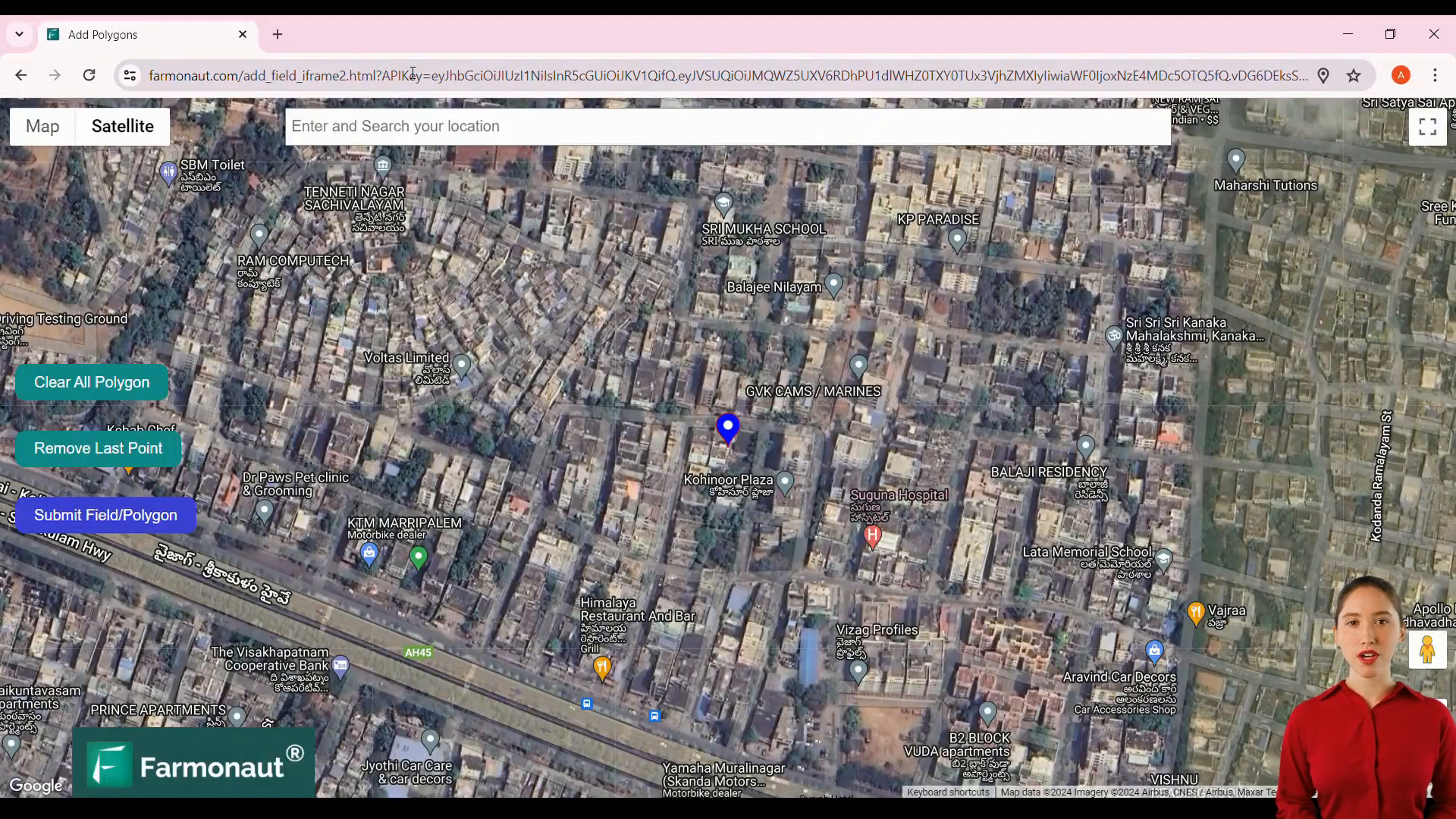
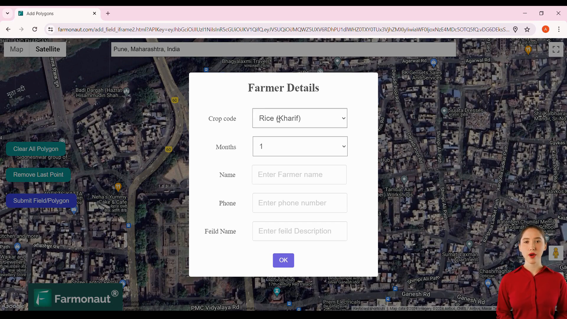
Table of Contents
- 🌱 The Power of Satellite Monitoring in Agriculture
- 🔧 Getting Started with the iFrame Tool
- 🗺️ Selecting Your Field Location
- 📝 Entering Field Details
- 🚀 Submitting Your Field for Monitoring
- 🌟 Benefits of Using the iFrame for Satellite Monitoring
- 🤔 Frequently Asked Questions
- 🌍 Conclusion: Embracing the Future of Agriculture
🌱 The Power of Satellite Monitoring in Agriculture
Satellite monitoring has become an indispensable tool in modern agriculture. According to recent statistics, the global agricultural monitoring market is expected to reach $1.4 billion by 2025, growing at a CAGR of 12.4% from 2020 to 2025. This technology allows farmers to:- Monitor crop health in real-time
- Detect early signs of pest infestations or diseases
- Optimize irrigation and fertilizer application
- Predict yields with greater accuracy
🔧 Getting Started with the iFrame Tool
The iFrame tool is a powerful agriculture technology industry web app development solution that simplifies the process of adding fields for satellite monitoring. Here’s how to get started:- Open the URL provided by Farmonaut with your unique API key
- Ensure you have the correct API key, as it serves as an identifier for your account
🗺️ Selecting Your Field Location
Once you’ve accessed the iFrame tool, follow these steps to select your field location:- Use the search bar to find your preferred location
- Select at least three points on the map to define your field boundaries
- Ensure accuracy in your selection to get the most precise monitoring results
📝 Entering Field Details
After defining your field boundaries, you’ll need to provide some additional information:- Crop code (required)
- Month name (optional)
- Phone number (optional)
- Field name (optional)
🚀 Submitting Your Field for Monitoring
Once you’ve entered all the necessary information, simply submit your field. The system will process your request, and your field will be successfully added for satellite monitoring. By following these simple steps, you’re harnessing the power of agriculture technology industry web app development to improve your farming practices and boost productivity.🌟 Benefits of Using the iFrame for Satellite Monitoring
Implementing this custom web app for agriculture technology offers numerous advantages:- Easy integration with existing farm management systems
- Real-time data access for timely decision-making
- Reduced need for manual field inspections
- Improved resource allocation and cost savings
- Enhanced environmental sustainability through precise resource management
