Revolutionizing Agriculture: How Satellite Technology is Transforming Crop Monitoring
At Farmonaut, we’re passionate about revolutionizing agriculture through cutting-edge technology. Today, we’re excited to share an inspiring story that showcases the power of satellite-based crop monitoring and its impact on precision agriculture.
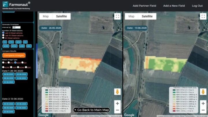
A Tale of Two Images: Crop Growth in Hungary
One of our esteemed users, Dr. Tamas Ratonyi from Hungary, Europe, recently shared a fascinating comparison of his field captured by satellites. This side-by-side analysis reveals the remarkable crop growth over just 17 days, from May 26th to June 13th, 2020.
The field in question spans an impressive 5 hectares, and the satellite imagery tells an intriguing story:
- More than 3 hectares have already reached maturity and are ready for harvest.
- The remaining area is expected to mature within the next 7-10 days.
This level of detailed insight is a game-changer for farmers like Dr. Ratonyi. By having access to precise crop maturity data, they can make informed decisions about when and where to harvest, maximizing yield and efficiency.
The Power of Precision Agriculture
Precision agriculture is at the heart of what we do at Farmonaut. By leveraging satellite technology, we’re able to provide farmers with unprecedented levels of information about their fields. This data-driven approach to farming offers numerous benefits:
- Optimized resource use (water, fertilizers, pesticides)
- Reduced environmental impact
- Increased crop yields
- Better farm management and planning
- Cost savings through targeted interventions
Our satellite-based monitoring system is designed to be accessible and user-friendly, available through our mobile apps on Google Play Store and Apple App Store, as well as our Web App.
Understanding Satellite Image Bands
To fully appreciate the power of satellite-based crop monitoring, it’s essential to understand the concept of satellite image bands. These are specific wavelengths of light captured by satellites, each revealing different aspects of the Earth’s surface.
At Farmonaut, we utilize various bands to gather comprehensive data about crop health and soil conditions:
- Red Band: Sensitive to chlorophyll absorption, indicating plant health
- Near-Infrared (NIR) Band: Reflects leaf structure and biomass
- Short-Wave Infrared (SWIR) Band: Provides information on soil and plant moisture content
- Thermal Infrared Band: Measures surface temperature, useful for detecting water stress
By analyzing these bands in combination, we can create detailed maps and indices that provide invaluable insights into crop health, growth stages, and potential issues.
Farmonaut: Leading the Way in Agricultural Innovation
At Farmonaut, we’re committed to making precision agriculture accessible to farmers worldwide. Our platform offers a range of features designed to revolutionize farming practices:
- Real-time crop health monitoring
- AI-powered advisory system (Jeevn AI)
- Blockchain-based product traceability
- Fleet and resource management tools
- Carbon footprint tracking
These technologies work together to provide a comprehensive farm management solution that’s both powerful and user-friendly.
Comparing Farmonaut to Traditional Monitoring Methods
While drones and IoT devices have their place in modern agriculture, satellite-based monitoring offers unique advantages. Here’s how Farmonaut’s satellite system compares:
| Feature | Farmonaut Satellite System | Drone Monitoring | IoT-based Monitoring |
|---|---|---|---|
| Coverage Area | Large-scale (entire farms) | Limited by flight time and regulations | Requires multiple sensors for large areas |
| Frequency of Data Collection | Regular intervals (as frequent as daily) | On-demand, weather-dependent | Continuous, but limited to sensor locations |
| Initial Investment | Low (subscription-based) | High (equipment and training) | Moderate to high (sensors and infrastructure) |
| Operational Costs | Low | Moderate (maintenance, pilot fees) | Low to moderate (sensor replacement, data plans) |
| Data Processing | Automated, AI-driven | Often requires manual processing | Automated, but limited to sensor data |
| Scalability | Highly scalable | Limited by equipment and regulations | Requires additional sensors for scaling |
The Future of Farming: Data-Driven and Sustainable
As we look to the future, it’s clear that data-driven farming practices will play a crucial role in meeting global food demands while minimizing environmental impact. Satellite-based monitoring, like that offered by Farmonaut, is at the forefront of this agricultural revolution.
By providing farmers with real-time insights into their crops’ health and growth patterns, we’re enabling more informed decision-making and resource management. This not only leads to increased yields and profitability but also promotes sustainable farming practices that are essential for our planet’s future.
Empowering Farmers Worldwide
At Farmonaut, our mission goes beyond providing cutting-edge technology. We’re committed to empowering farmers of all sizes, from small-scale operations to large agribusinesses. Our platform is designed to be:
- Accessible: Available on multiple platforms and devices
- Affordable: Subscription-based model to suit various budgets
- User-friendly: Intuitive interface and clear, actionable insights
- Scalable: Grows with your farming operation
We believe that by making precision agriculture tools widely available, we can contribute to a more sustainable and productive global food system.
Beyond Crop Monitoring: Farmonaut’s Comprehensive Suite
While our satellite-based crop monitoring is a cornerstone of our offerings, Farmonaut provides a range of additional services to support modern farming:
1. Jeevn AI Advisory System
Our AI-powered advisory system analyzes satellite data, weather patterns, and historical information to provide personalized recommendations for crop management. This includes advice on:
- Optimal planting and harvesting times
- Irrigation scheduling
- Fertilizer application
- Pest and disease management
2. Blockchain-Based Traceability
In an era where consumers are increasingly concerned about the origin and journey of their food, our blockchain technology offers unparalleled transparency. This system:
- Tracks products from farm to table
- Ensures authenticity and reduces fraud
- Builds consumer trust
- Supports fair trade practices
3. Fleet and Resource Management
Efficient management of farm equipment and resources is crucial for profitability. Our tools help:
- Optimize vehicle routes and usage
- Monitor fuel consumption
- Schedule maintenance
- Track inventory of seeds, fertilizers, and other inputs
4. Carbon Footprint Tracking
As sustainability becomes increasingly important in agriculture, our carbon footprint tracking feature allows farmers to:
- Monitor greenhouse gas emissions
- Identify areas for reduction
- Participate in carbon credit programs
- Demonstrate environmental stewardship
Farmonaut API: Powering Agricultural Innovation
For developers and businesses looking to integrate our powerful satellite and weather data into their own applications, we offer the Farmonaut API. This robust API provides access to:
- High-resolution satellite imagery
- Vegetation indices (e.g., NDVI, EVI)
- Soil moisture data
- Weather forecasts and historical data
- Crop-specific analytics
By leveraging our API, agtech companies, researchers, and government agencies can build innovative solutions that further advance the field of precision agriculture. For detailed documentation, visit our API Developer Docs.
Success Stories: Farmers Thriving with Farmonaut
The true measure of our success lies in the stories of farmers who have transformed their operations using Farmonaut. Here are a few examples:
Case Study 1: Optimizing Water Usage in Drought-Prone Regions
A group of farmers in a water-scarce region of India used Farmonaut’s soil moisture tracking to reduce water consumption by 30% while maintaining crop yields. This not only saved precious resources but also reduced their operational costs significantly.
Case Study 2: Precision Harvesting for Maximum Yield
A large wheat farm in Australia used our crop maturity data to implement a staged harvesting approach. By harvesting different sections of their fields at optimal times, they increased their overall yield by 15% compared to the previous year.
Case Study 3: Early Pest Detection Saves Crops
A coffee plantation in Colombia utilized our early warning system to detect the onset of a potential pest infestation. By taking swift action based on our alerts, they were able to contain the problem and save an estimated 70% of the potentially affected crop.
Join the Agricultural Revolution
Are you ready to take your farming operation to the next level? Join thousands of farmers worldwide who are already benefiting from Farmonaut’s cutting-edge technology. Our flexible subscription plans cater to farms of all sizes and types.
Frequently Asked Questions (FAQ)
1. How often are satellite images updated?
Our satellite imagery is updated regularly, with frequencies ranging from daily to weekly, depending on your subscription plan and location.
2. Is Farmonaut suitable for small farms?
Absolutely! We offer plans tailored for farms of all sizes, making precision agriculture accessible to everyone.
3. Do I need special equipment to use Farmonaut?
No special equipment is required. You can access all features through our mobile apps or web platform using your existing smartphone, tablet, or computer.
4. How accurate is the crop health monitoring?
Our crop health monitoring is highly accurate, with an average accuracy rate of over 90% for most crops and conditions.
5. Can Farmonaut help with crop insurance claims?
Yes, our detailed satellite imagery and crop health data can provide valuable evidence to support crop insurance claims in case of weather-related damages or other covered events.
6. Is my farm data secure?
We take data security very seriously. All farm data is encrypted and stored securely, and we never share individual farm data without explicit permission.
7. Can Farmonaut integrate with other farm management software?
Yes, we offer API integration options that allow Farmonaut to work seamlessly with many popular farm management platforms.
Conclusion: Embracing the Future of Agriculture
As we’ve explored throughout this blog post, satellite-based crop monitoring and precision agriculture are not just futuristic concepts – they’re here now, and they’re transforming farming as we know it. At Farmonaut, we’re proud to be at the forefront of this agricultural revolution, providing farmers worldwide with the tools they need to increase productivity, sustainability, and profitability.
From the fields of Hungary to the coffee plantations of Colombia, our technology is making a real difference in the lives of farmers and the health of our planet. As we look to the future, we’re excited about the potential for further innovations in agricultural technology and the positive impact they will have on global food security and environmental stewardship.
We invite you to join us on this journey. Whether you’re a small family farm or a large agribusiness, Farmonaut has the tools and expertise to help you thrive in the modern agricultural landscape. Together, we can cultivate a brighter, more sustainable future for agriculture and for our world.
Ready to revolutionize your farming practices? Sign up for Farmonaut today and experience the power of precision agriculture firsthand!
