Revolutionizing Palm Oil Production: Farmonaut’s Satellite-AI Based Farm Intelligence
In the ever-evolving agricultural landscape, oil palm plantations play a crucial role in meeting the global demand for vegetable oil. As the industry faces numerous challenges, a groundbreaking solution has emerged to revolutionize plantation management: Farmonaut’s Satellite-AI Based Farm Intelligence system for automated oil palm tree detection and mapping.

Revolutionizing Kansas Hay Farming with Farmonaut’s Satellite-AI Based Farm Intelligence
In the heart of America’s breadbasket, Kansas hay farmers face unique challenges that demand innovative solutions. Enter JEEVN AI, an groundbreaking farm intelligence system by Farmonaut Technologies that’s set to transform the landscape of hay production in the Sunflower State. This article explores how Farmonaut’s Satellite-AI Based Farm Intelligence is addressing the specific needs of Kansas hay farmers, offering a glimpse into the future of agriculture in this vital region.

Revolutionizing Kansas Sorghum Farming with Farmonaut’s Satellite-AI Based Farm Intelligence
In the heartland of America, Kansas sorghum farmers face unique challenges that demand innovative solutions. Enter JEEVN AI, an advanced farm intelligence system developed by Farmonaut Technologies. This cutting-edge tool is set to transform the landscape of sorghum farming in Kansas by harnessing the power of artificial intelligence and satellite technology.
Kansas, known for its vast sorghum fields that contribute significantly to the state’s agricultural economy, is poised to benefit greatly from Farmonaut’s Satellite-AI Based Farm Intelligence. With sorghum production averaging around 200 million bushels annually in Kansas, the potential impact of JEEVN AI on yield optimization and resource management is immense.

Revolutionizing Kansas Soybean Farming with Farmonaut’s Satellite-AI Based Farm Intelligence
In the heart of America’s breadbasket, Kansas soybean farmers face unique challenges that demand innovative solutions. Enter JEEVN AI, an advanced farm intelligence system developed by Farmonaut Technologies. This cutting-edge tool is poised to transform the landscape of soybean farming in Kansas, offering precision, efficiency, and data-driven insights that could significantly boost yields and sustainability.
Kansas, ranking 10th nationally in soybean production with over 4.7 million acres dedicated to the crop, stands to benefit immensely from the integration of Farmonaut’s Satellite-AI Based Farm Intelligence. JEEVN AI brings science and technology to the forefront of agricultural practices, eliminating guesswork and providing Kansas farmers with actionable insights tailored to their specific needs.

Revolutionizing Kansas Corn Farming with Farmonaut’s Satellite-AI Based Farm Intelligence
In the heartland of America, where corn fields stretch as far as the eye can see, Kansas farmers are facing unprecedented challenges. From unpredictable weather patterns to fluctuating market demands, the need for precision and efficiency in farming has never been greater. Enter JEEVN AI, an innovative solution by Farmonaut Technologies that’s set to revolutionize the way Kansas corn farmers approach their operations.

Revolutionizing Kansas Wheat Farming with Farmonaut’s Satellite-AI Based Farm Intelligence
in the heart of America’s breadbasket, Kansas wheat farmers face unique challenges that demand innovative solutions. Enter JEEVN AI, an advanced farm intelligence system by Farmonaut Technologies, designed to revolutionize agricultural practices in the Sunflower State and beyond. This cutting-edge tool harnesses the power of artificial intelligence to provide Kansas wheat farmers with precise, actionable insights that can significantly boost their farm’s productivity and sustainability.

Revolutionizing Arkansas Wheat Farming with Farmonaut’s Satellite-AI Based Farm Intelligence
In the heart of Arkansas, where wheat fields stretch as far as the eye can see, a new technological revolution is taking root. Farmonaut’s Satellite-AI Based Farm Intelligence, known as JEEVN AI, is transforming the landscape of agriculture in the Natural State. This innovative solution is set to address the unique challenges faced by Arkansas wheat farmers, offering precision, efficiency, and data-driven insights that promise to elevate crop yields and farm profitability.

Revolutionizing Arkansas Corn Farming: Farmonaut’s Satellite-AI Based Farm Intelligence
In the heart of the Natural State, where corn fields stretch as far as the eye can see, Arkansas farmers are facing new challenges in an ever-changing agricultural landscape. Enter JEEVN AI, an innovative solution by Farmonaut Technologies that’s set to revolutionize corn farming in Arkansas. This powerful tool harnesses the capabilities of artificial intelligence to provide farmers with precise, actionable insights, ensuring their farms thrive in an age where precision and efficiency are paramount.
Arkansas, known for its rich agricultural heritage, produced over 147 million bushels of corn in 2022. However, with increasing pressures from climate change, market fluctuations, and the need for sustainable practices, corn farmers in the state are seeking advanced solutions to maintain their competitive edge. JEEVN AI steps in to eliminate guesswork and bring science and technology to the forefront of agricultural practices in the Natural State.

Revolutionizing Arkansas Cotton Farming with Farmonaut’s Satellite-AI Based Farm Intelligence
In the heart of Arkansas, where cotton fields stretch as far as the eye can see, a new era of farming is dawning. Farmonaut’s Satellite-AI Based Farm Intelligence, known as JEEVN AI, is set to transform the way Arkansas cotton farmers approach their craft. This innovative solution promises to bring precision, efficiency, and data-driven decision-making to the forefront of agricultural practices in the Natural State.

Revolutionizing Arkansas Soybean Farming with Farmonaut’s Satellite-AI Based Farm Intelligence
In the heart of the Natural State, where soybeans reign as the top row crop, Arkansas farmers are constantly seeking ways to optimize their yields and overcome challenges. Enter JEEVN AI, an innovative solution by Farmonaut Technologies that’s set to transform the landscape of soybean farming in Arkansas. This cutting-edge tool harnesses the power of Farmonaut’s Satellite-AI Based Farm Intelligence to provide precise, actionable insights tailored to the unique needs of Arkansas soybean growers.
With Arkansas producing over 150 million bushels of soybeans annually across 3 million acres, the potential impact of JEEVN AI on the state’s agricultural economy is immense. This powerful AI system integrates satellite intelligence, local weather data, and farm-specific information to deliver recommendations that could help Arkansas farmers push their average yield of 50 bushels per acre to new heights.

Revolutionizing Arkansas Rice Farming: Farmonaut’s Satellite-AI Based Farm Intelligence
In the heartland of American rice production, Arkansas farmers are constantly seeking ways to improve their yields and efficiency. Enter JEEVN AI, an innovative solution by Farmonaut Technologies that’s set to transform the rice farming landscape in the Natural State. This cutting-edge tool harnesses the power of artificial intelligence and satellite technology to provide Arkansas rice farmers with precise, actionable insights tailored to their specific needs.
Arkansas, producing nearly 50% of U.S. rice, faces unique challenges in maintaining its agricultural dominance. JEEVN AI steps in to address these challenges head-on, offering a suite of features designed to optimize every aspect of rice cultivation in the region.

Revolutionizing Sorghum Farming in Colorado with Farmonaut’s Satellite-AI Based Farm Intelligence
In the vast plains of Colorado, where sorghum fields stretch as far as the eye can see, a new era of farming is dawning. Farmonaut Technologies introduces JEEVN AI, an innovative solution that promises to transform the agricultural landscape for sorghum farmers across the Centennial State. This cutting-edge tool harnesses the power of artificial intelligence and satellite technology to provide Colorado farmers with precise, actionable insights, ensuring their sorghum crops thrive in the unique climate and conditions of the region.
Colorado’s sorghum industry, which contributes significantly to the state’s agricultural output, faces unique challenges. With unpredictable weather patterns and the need for efficient water management in the semi-arid climate, Colorado sorghum farmers require specialized solutions. JEEVN AI steps in to address these specific needs, offering a tailored approach to sorghum cultivation that aligns with the state’s agricultural goals and environmental considerations.

Revolutionizing Colorado Potato Farming: Farmonaut’s Satellite-AI Based Farm Intelligence
In the vast agricultural landscape of Colorado, potato farmers are constantly seeking innovative ways to improve their yields and optimize their operations. Enter JEEVN AI, an groundbreaking solution by Farmonaut Technologies that’s set to transform the way Colorado’s potato industry approaches farming. This powerful tool harnesses the capabilities of artificial intelligence to provide farmers with precise, actionable insights that ensure their farms thrive in the unique climate and conditions of the Centennial State.
Colorado’s potato industry, valued at over $300 million annually, faces unique challenges due to the state’s diverse topography and climate variations. JEEVN AI steps in to eliminate guesswork and bring science and technology to the forefront of agricultural practices, addressing the specific needs of Colorado potato farmers.

Revolutionizing Colorado Wheat Farming: Farmonaut’s Satellite-AI Based Farm Intelligence
In the vast plains of Colorado, where wheat fields stretch as far as the eye can see, a new era of farming is dawning. Farmonaut Technologies introduces JEEVN AI, an innovative solution that promises to transform the landscape of wheat cultivation in the Centennial State. This cutting-edge tool harnesses the power of artificial intelligence to provide Colorado wheat farmers with precise, actionable insights, ensuring their farms thrive in an increasingly challenging agricultural environment.
Colorado, known for its high-quality hard red winter wheat, produces an average of 86 million bushels annually. However, farmers face numerous challenges, from unpredictable weather patterns to resource management. JEEVN AI steps in to eliminate guesswork and bring science and technology to the forefront of agricultural practices in this crucial wheat-producing region.

Revolutionizing Colorado’s Hay Farming: Farmonaut’s Satellite-AI Based Farm Intelligence
In the vast plains and mountainous regions of Colorado, hay farming plays a crucial role in the state’s agricultural landscape. As the industry faces challenges such as unpredictable weather patterns and resource management, Farmonaut Technologies introduces JEEVN AI, a cutting-edge solution designed to revolutionize farming practices. This Satellite-AI Based Farm Intelligence system is poised to transform the way Colorado’s hay farmers approach their operations.
JEEVN AI harnesses the power of artificial intelligence to provide Colorado hay farmers with precise, actionable insights that ensure their farms thrive in an increasingly competitive market. By eliminating guesswork and bringing science and technology to the forefront of agricultural practices, JEEVN AI addresses the unique challenges faced by hay farmers in the Centennial State.

Revolutionizing Colorado Corn Farming with Farmonaut’s Satellite-AI Based Farm Intelligence
In the vast cornfields of Colorado, where precision and efficiency are paramount, a new era of farming is dawning. Farmonaut’s Satellite-AI Based Farm Intelligence, known as JEEVN AI, is revolutionizing the way corn farmers approach their craft. This innovative solution is designed to eliminate guesswork and bring cutting-edge science and technology to the forefront of agricultural practices in the Centennial State.
Colorado’s corn industry, valued at over $600 million annually, faces unique challenges due to the state’s diverse topography and climate. JEEVN AI steps in as a powerful ally, harnessing the capabilities of artificial intelligence to provide Colorado corn farmers with precise, actionable insights that ensure their farms thrive in this competitive landscape.

Revolutionizing Texas Wheat Farming: Farmonaut’s Satellite-AI Based Farm Intelligence
In the vast expanse of Texas farmlands, where wheat fields stretch as far as the eye can see, a new technological revolution is taking root. Farmonaut’s Satellite-AI Based Farm Intelligence, known as JEEVN AI, is transforming the way Texas wheat farmers approach their craft. This innovative solution is designed to address the unique challenges faced by wheat producers in the Lone Star State, bringing precision and efficiency to the forefront of agricultural practices.
Texas, being the third-largest wheat-producing state in the U.S., with an average annual production of 89 million bushels, stands to benefit significantly from this cutting-edge technology. JEEVN AI harnesses the power of artificial intelligence to provide Texas wheat farmers with precise, actionable insights that ensure their farms thrive in the face of unpredictable weather patterns and market fluctuations.

Revolutionizing Texas Sorghum Farming with Farmonaut’s Satellite-AI Based Farm Intelligence
In the vast agricultural landscape of Texas, where sorghum reigns as a crucial crop, precision and efficiency are more important than ever. Enter JEEVN AI, an innovative solution by Farmonaut Technologies that’s set to transform the way Texan sorghum farmers approach their craft. This cutting-edge tool harnesses the power of Farmonaut’s Satellite-AI Based Farm Intelligence to provide farmers with precise, actionable insights, ensuring their farms thrive in the face of unique challenges.
Texas is the second-largest producer of sorghum in the United States, with over 1.9 million acres dedicated to this versatile crop. However, Texan sorghum farmers face numerous challenges, including unpredictable weather patterns, pest pressures, and the need for efficient resource management. JEEVN AI addresses these issues head-on, offering a comprehensive solution tailored to the specific needs of Texas sorghum production.

Revolutionizing Texas Corn Farming: Farmonaut’s Satellite-AI Based Farm Intelligence
In the heart of Texas, where corn fields stretch as far as the eye can see, a revolution is brewing. Farmonaut Technologies has introduced JEEVN AI, an innovative solution that promises to transform the landscape of corn farming in the Lone Star State. This powerful tool harnesses the capabilities of artificial intelligence to provide Texas corn farmers with precise, actionable insights that ensure their farms thrive in an age where precision and efficiency are paramount.
With Texas being the 12th largest corn-producing state in the U.S., contributing significantly to the nation’s corn production, the introduction of JEEVN AI couldn’t be more timely. This cutting-edge technology is set to address the unique challenges faced by Texas corn farmers, from unpredictable weather patterns to soil nutrient management and water conservation.

Revolutionizing Texas Hay Farming: Farmonaut’s Satellite-AI Based Farm Intelligence
In the vast expanses of Texas, where hay production is a cornerstone of agriculture, a new technological frontier is emerging. Farmonaut’s Satellite-AI Based Farm Intelligence, known as JEEVN AI, is set to transform the landscape of hay farming in the Lone Star State. This innovative solution addresses the unique challenges faced by Texas hay farmers, offering precision and efficiency in an industry where every blade of grass counts.
Texas, with its 1.3 million acres dedicated to hay production, stands to benefit significantly from this cutting-edge technology. JEEVN AI harnesses the power of artificial intelligence to provide Texas hay farmers with actionable insights, ensuring their operations thrive in the face of unpredictable weather patterns and market fluctuations.

Revolutionizing Texas Cotton Farming: Farmonaut’s Satellite-AI Based Farm Intelligence
In the vast expanse of Texas cotton fields, where precision and efficiency are paramount, a new technological marvel is set to transform the agricultural landscape. Farmonaut’s Satellite-AI Based Farm Intelligence, known as JEEVN AI, is stepping in to eliminate guesswork and bring cutting-edge science to the forefront of cotton farming practices in the Lone Star State.
Texas, the leading cotton-producing state in the U.S., faces unique challenges in maintaining its agricultural dominance. With unpredictable weather patterns, water scarcity, and the constant threat of pests, Texas cotton farmers need innovative solutions to stay ahead. JEEVN AI emerges as that solution, offering precise, actionable insights tailored to the specific needs of Texas cotton growers.

Revolutionizing Bell Pepper Farming in Florida with Farmonaut’s Satellite-AI Based Farm Intelligence
In the sun-soaked fields of Florida, where bell peppers thrive under the warm climate, a new technological revolution is taking root. Farmonaut’s Satellite-AI Based Farm Intelligence, known as JEEVN AI, is set to transform the way bell pepper farmers approach their craft. This innovative solution brings precision and efficiency to the forefront of agricultural practices, eliminating guesswork and integrating cutting-edge science into every aspect of farming.
Florida’s bell pepper industry, valued at over $235 million annually, faces unique challenges such as unpredictable weather patterns, pest pressures, and the need for efficient resource management. JEEVN AI addresses these issues head-on, offering tailored solutions that resonate with the specific needs of Florida’s bell pepper growers.

Revolutionizing Strawberry Farming in Florida with Farmonaut’s Satellite-AI Based Farm Intelligence
In the heart of Florida’s strawberry fields, a revolution is brewing. Farmonaut Technologies has introduced JEEVN AI, an innovative solution that promises to transform the landscape of strawberry farming in the Sunshine State. This cutting-edge tool harnesses the power of Farmonaut’s Satellite-AI Based Farm Intelligence to provide Florida’s strawberry farmers with precise, actionable insights that ensure their farms thrive in an increasingly competitive market.
Florida, known as the winter strawberry capital of the world, produces about 15% of the nation’s strawberries. With an industry valued at over $300 million annually, the stakes are high for Florida’s strawberry farmers. JEEVN AI steps in to eliminate guesswork and bring science and technology to the forefront of agricultural practices in this crucial sector.

Revolutionizing Sugarcane Farming in Florida with Farmonaut’s Satellite-AI Based Farm Intelligence
In the heart of Florida’s agricultural landscape, where sugarcane fields stretch as far as the eye can see, a revolutionary technology is taking root. Farmonaut’s Satellite-AI Based Farm Intelligence, known as JEEVN AI, is set to transform the way Florida’s sugarcane farmers approach their craft. This innovative solution comes at a crucial time for the Sunshine State’s sugar industry, which produces over 50% of the nation’s cane sugar and contributes significantly to the state’s economy.
JEEVN AI harnesses the power of artificial intelligence and satellite technology to provide Florida’s sugarcane farmers with precise, actionable insights. In an industry where efficiency and productivity are paramount, this tool eliminates guesswork and brings cutting-edge science to the forefront of agricultural practices.

Revolutionizing Florida’s Tomato Farming: Farmonaut’s Satellite-AI Based Farm Intelligence
In the heart of Florida’s agricultural landscape, tomato farmers face unique challenges that demand innovative solutions. Enter JEEVN AI, an groundbreaking farm intelligence system developed by Farmonaut Technologies. This cutting-edge tool is set to transform the way Florida’s tomato industry operates, bringing precision and efficiency to the forefront of agricultural practices.
Florida, known as the Sunshine State, is a major player in the U.S. tomato industry. With over 30,000 acres dedicated to tomato cultivation, the state produces nearly 40% of the nation’s fresh-market tomatoes. However, Florida tomato farmers grapple with issues such as pest pressure, water management, and soil health. JEEVN AI addresses these challenges head-on, offering a comprehensive solution tailored to the specific needs of Florida’s tomato growers.

Revolutionizing Florida’s Orange Groves: Farmonaut’s Satellite-AI Based Farm Intelligence
In the heart of the Sunshine State, where orange groves stretch as far as the eye can see, a technological revolution is taking root. Farmonaut Technologies introduces JEEVN AI, an innovative solution poised to transform the landscape of Florida’s citrus industry. This cutting-edge tool harnesses the power of artificial intelligence to provide orange farmers with precise, actionable insights, ensuring their groves not only survive but thrive in an era where precision and efficiency are paramount.
Florida’s citrus industry, valued at over $6.5 billion annually, has faced numerous challenges in recent years, from citrus greening disease to unpredictable weather patterns. JEEVN AI steps in as a beacon of hope, offering a scientific approach to combat these issues and optimize orange production across the state.

Revolutionizing Delaware Wheat Farming: Farmonaut’s Satellite-AI Based Farm Intelligence
In the heart of Delaware’s agricultural landscape, where precision and efficiency are paramount, a groundbreaking solution is emerging to transform the way wheat farmers operate. Farmonaut’s Satellite-AI Based Farm Intelligence, known as JEEVN AI, is stepping in to eliminate guesswork and bring cutting-edge science and technology to the forefront of agricultural practices in the First State.

Revolutionizing Delaware Soybean Farming with Farmonaut’s Satellite-AI Based Farm Intelligence
In the heart of Delaware, where soybeans reign as a crucial crop, a new technological marvel is set to transform the agricultural landscape. Farmonaut’s Satellite-AI Based Farm Intelligence, known as JEEVN AI, is bringing precision and efficiency to the forefront of farming practices in the First State.

Revolutionizing Delaware Corn Farming: Farmonaut’s Satellite-AI Based Farm Intelligence
In the heart of Delaware, where corn fields stretch as far as the eye can see, a new era of farming is dawning. Farmonaut’s Satellite-AI Based Farm Intelligence, known as JEEVN AI, is set to transform the agricultural landscape of the First State. This innovative solution promises to bring precision, efficiency, and data-driven decision-making to Delaware’s corn farmers, addressing the unique challenges they face in this region.

Revolutionizing Indiana Tomato Farming: Farmonaut’s Satellite-AI Based Farm Intelligence
In the heartland of America, Indiana’s tomato farmers are facing unprecedented challenges. From unpredictable weather patterns to evolving pest pressures, the need for precision and efficiency in farming has never been greater. Enter JEEVN AI, an innovative solution by Farmonaut Technologies that’s set to transform the landscape of tomato cultivation in the Hoosier State.

Revolutionizing Indiana’s Hay Farming: Farmonaut’s Satellite-AI Based Farm Intelligence
In the heartland of America, Indiana’s hay farmers are facing unprecedented challenges. From unpredictable weather patterns to fluctuating market demands, the need for precision and efficiency in farming has never been more critical. Enter JEEVN AI, an innovative solution by Farmonaut Technologies that’s set to transform the landscape of hay farming in the Hoosier State.

Revolutionizing Indiana Wheat Farming: Farmonaut’s Satellite-AI Based Farm Intelligence
In the heartland of America, Indiana’s wheat farmers face unique challenges in their quest for agricultural excellence. As the state’s wheat production continues to play a crucial role in the national economy, innovative solutions are needed to maintain Indiana’s competitive edge. Enter JEEVN AI, an groundbreaking farm intelligence system by Farmonaut Technologies, poised to transform the landscape of wheat farming in the Hoosier State.

Revolutionizing Indiana Soybean Farming: Farmonaut’s Satellite-AI Based Farm Intelligence
In the heart of America’s breadbasket, Indiana soybean farmers face unique challenges that demand innovative solutions. Enter JEEVN AI, an groundbreaking farm intelligence system developed by Farmonaut Technologies. This cutting-edge tool is poised to transform the landscape of soybean farming in the Hoosier State, offering precision and efficiency that were once thought impossible.

Revolutionizing Indiana Corn Farming: Farmonaut’s Satellite-AI Based Farm Intelligence
In the heartland of America, Indiana’s corn farmers face unique challenges in maintaining their status as one of the nation’s top corn producers. With the agricultural landscape evolving rapidly, precision and efficiency have become paramount. Enter JEEVN AI, an innovative solution by Farmonaut Technologies that’s set to transform the way Indiana’s corn belt operates.

Revolutionizing California Walnut Farming with Farmonaut’s Satellite-AI Based Farm Intelligence
In the heart of California’s agricultural landscape, walnut farmers face unique challenges that demand innovative solutions. Enter JEEVN AI, an advanced farm intelligence system by Farmonaut Technologies, poised to transform the way California’s walnut orchards are managed and cultivated. This cutting-edge tool harnesses the power of artificial intelligence and satellite technology to provide precise, actionable insights tailored specifically to the needs of walnut growers in the Golden State.

Revolutionizing California’s Lettuce Farming: Farmonaut’s Satellite-AI Based Farm Intelligence
In the heart of California’s agricultural landscape, where precision and efficiency are paramount, JEEVN AI by Farmonaut Technologies emerges as a groundbreaking solution for lettuce farmers. This innovative tool harnesses the power of artificial intelligence to revolutionize farming practices, particularly in the state’s thriving lettuce industry.

Revolutionizing California’s Strawberry Farming with Farmonaut’s Satellite-AI Based Farm Intelligence
In the heart of California’s agricultural landscape, where strawberry fields stretch as far as the eye can see, a new era of farming is dawning. Farmonaut’s Satellite-AI Based Farm Intelligence, known as JEEVN AI, is set to transform the way California’s strawberry farmers approach their craft. This innovative solution brings precision, efficiency, and data-driven decision-making to the forefront of agricultural practices in the Golden State.

Revolutionizing California’s Almond Farming with Farmonaut’s Satellite-AI Based Farm Intelligence
In the heart of California’s Central Valley, where almonds reign supreme, a new era of farming is dawning. Farmonaut’s Satellite-AI Based Farm Intelligence, known as JEEVN AI, is set to transform the way almond growers manage their orchards, promising unprecedented precision, efficiency, and sustainability.

Revolutionizing Arizona Broccoli Farming: Farmonaut’s Satellite-AI Based Farm Intelligence
In the sun-drenched fields of Arizona, where broccoli farming is a significant contributor to the state’s agricultural economy, precision and efficiency are paramount. Enter JEEVN AI, an innovative solution by Farmonaut Technologies that’s set to transform the landscape of broccoli cultivation in the Grand Canyon State. This powerful tool harnesses the capabilities of artificial intelligence to provide Arizona’s broccoli farmers with precise, actionable insights that ensure their farms thrive in the challenging desert climate.

Revolutionizing Arizona Citrus Farming with Farmonaut’s Satellite-AI Based Farm Intelligence
In the sun-drenched orchards of Arizona, where citrus farming is a cornerstone of the agricultural economy, a new era of precision and efficiency is dawning. Farmonaut’s Satellite-AI Based Farm Intelligence, known as JEEVN AI, is stepping in to transform the way citrus farmers approach their craft. This innovative solution is poised to address the unique challenges faced by Arizona’s citrus industry, which contributes significantly to the state’s $23.3 billion agricultural sector.

Revolutionizing Arizona’s Hay Farming: Farmonaut’s Satellite-AI Based Farm Intelligence
In the sun-drenched fields of Arizona, where hay production is a crucial agricultural activity, a new era of farming is dawning. Farmonaut Technologies introduces JEEVN AI, an innovative solution that promises to transform the landscape of hay farming in the Grand Canyon State. This cutting-edge tool harnesses the power of artificial intelligence to provide Arizona hay farmers with precise, actionable insights, ensuring their farms thrive in an increasingly challenging climate.

Revolutionizing Arizona Lettuce Farming: Farmonaut’s Satellite-AI Based Farm Intelligence
In the sun-drenched fields of Arizona, where lettuce farming is a cornerstone of the agricultural economy, a new era of precision and efficiency is dawning. Farmonaut’s Satellite-AI Based Farm Intelligence, known as JEEVN AI, is poised to transform the way Arizona’s lettuce farmers approach their craft. This innovative solution brings cutting-edge technology to the forefront of agricultural practices, offering a beacon of hope for an industry facing increasing challenges.

Revolutionizing Arizona Cotton Farming with Farmonaut’s Satellite-AI Based Farm Intelligence: JEEVN AI
In the sun-drenched fields of Arizona, where cotton reigns supreme, a new era of farming is dawning. Farmonaut’s Satellite-AI Based Farm Intelligence, JEEVN AI, is set to transform the landscape of agriculture in the Grand Canyon State. This innovative solution brings precision, efficiency, and data-driven decision-making to the forefront of cotton cultivation.

Revolutionizing Alabama Wheat Farming: Farmonaut’s Satellite-AI Based Farm Intelligence
In the heart of Alabama’s agricultural landscape, where wheat fields stretch as far as the eye can see, a technological revolution is taking root. Farmonaut’s Satellite-AI Based Farm Intelligence, known as JEEVN AI, is transforming the way Alabama wheat farmers approach their craft. This innovative solution is designed to bring precision, efficiency, and data-driven decision-making to the forefront of agricultural practices in the Yellowhammer State.

Revolutionizing Alabama Soybean Farming: Farmonaut’s Satellite-AI Based Farm Intelligence
In the heart of Alabama’s agricultural landscape, soybean farmers are facing new challenges and opportunities. With the introduction of JEEVN AI, an innovative solution by Farmonaut Technologies, the future of farming in the Yellowhammer State is looking brighter than ever. This cutting-edge tool is set to transform the way Alabama’s soybean farmers approach their craft, bringing precision and efficiency to the forefront of agricultural practices.

Revolutionizing Alabama Corn Farming with Farmonaut’s Satellite-AI Based Farm Intelligence
In the heart of Alabama’s agricultural landscape, corn farmers are facing unprecedented challenges. From unpredictable weather patterns to evolving pest pressures, the need for precision and efficiency in farming has never been more critical. Enter JEEVN AI, an innovative solution by Farmonaut Technologies that’s set to transform the way Alabama’s corn farmers approach their craft.

Revolutionizing Alabama’s Peanut Farming: Farmonaut’s Satellite-AI Based Farm Intelligence
In the heart of Alabama’s peanut country, where tradition meets innovation, a new era of farming is dawning. Farmonaut’s Satellite-AI Based Farm Intelligence, known as JEEVN AI, is set to transform the way Alabama’s peanut farmers approach their craft. This cutting-edge technology promises to bring precision, efficiency, and data-driven decision-making to the forefront of agricultural practices in the Yellowhammer State.

Revolutionizing Alabama Cotton Farming with Farmonaut Satellite-AI Based Farm Intelligence
In the heart of Alabama’s agricultural landscape, cotton farmers are facing new challenges and opportunities. With the introduction of JEEVN AI by Farmonaut Technologies, the future of farming is knocking on the doors of the Yellowhammer State. This innovative Farmonaut Satellite-AI Based Farm Intelligence system is set to transform the way Alabama’s cotton farmers approach their craft, bringing precision and efficiency to the forefront of agricultural practices.

Revolutionizing Nebraska Sorghum Farming: Farmonaut’s JEEVN AI Satellite and AI-based Farm Advisory
Discover how Farmonaut’s JEEVN AI is revolutionizing sorghum farming in Nebraska by providing satellite-based insights and tailored recommendations for farmers. Learn more about its innovative features.

🍇 Transforming California’s Vineyards with JEEVN AI by Farmonaut
Welcome, California vintners! From the fog-kissed valleys of Sonoma to the sun-drenched hills of Paso Robles, our Golden State is a viticultural paradise. With over 635,000 acres of wine grapes and more than 4,700 wineries, California isn’t just leading the U.S. wine industry – we’re shaping global wine trends. But as any seasoned vintner knows, our success comes with unique challenges. Today, we’re introducing JEEVN AI, an innovative solution by Farmonaut Technologies that’s set to transform how we nurture our precious vines and continue our legacy of world-class winemaking.

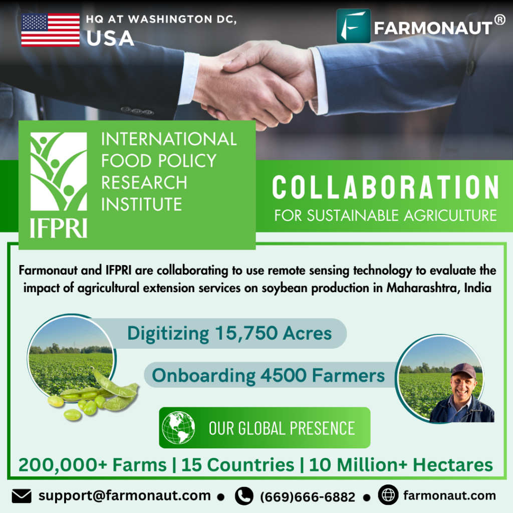
IFPRI Collaboration for Sustainable Agriculture
INTRODUCTION Farmonaut is collaborating with the International Food Policy Research


Research Collaboration with Chippy Pushpangathan on a DST funded project in Precision Agriculture
v Research Collaboration with Chippy Pushpangathan on a DST funded
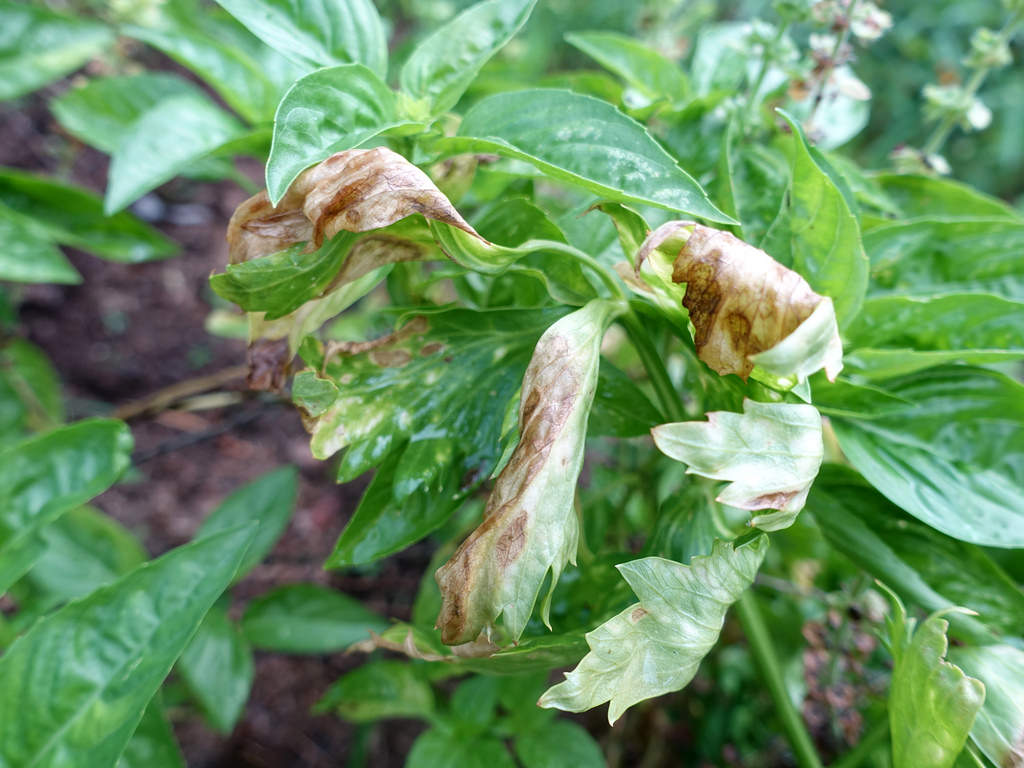
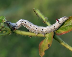
Hairy Caterpillars
Hairy Caterpillars Hairy caterpillars EUPROCTIS FRATERNA Factors – a- Defoliation
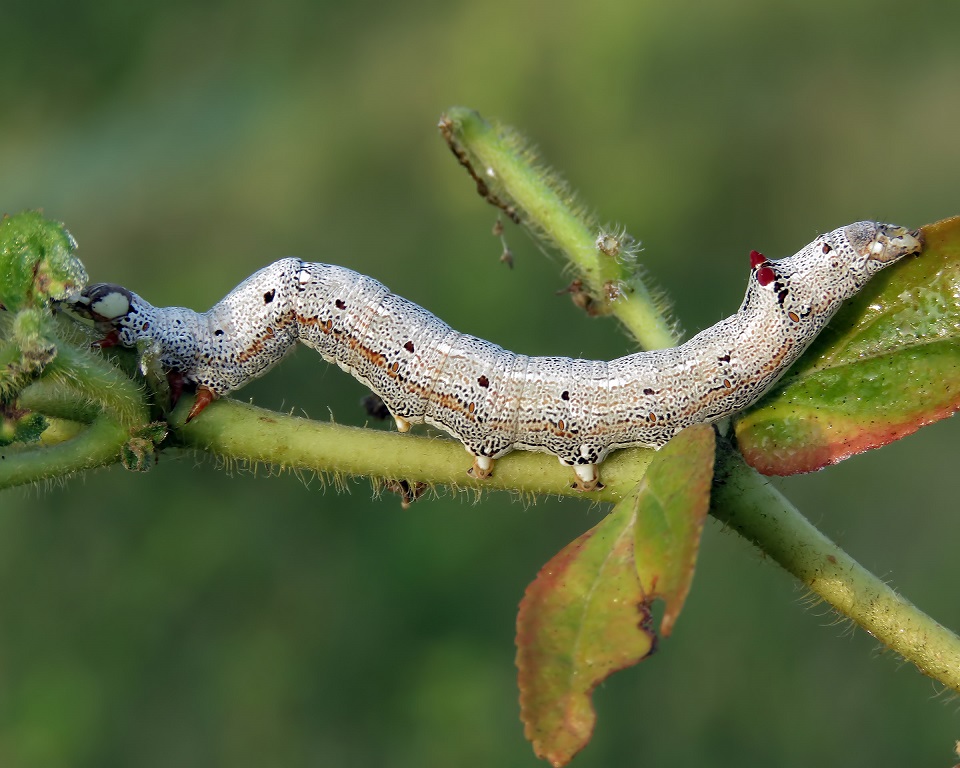
American Bollworm
American Bollworm American bollworm has been identified to attack more

Voice-Text Based Crop Issue Identification
Voice-Text Based Crop Issue Identification In India, several thousand tonnes
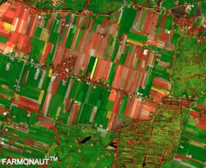
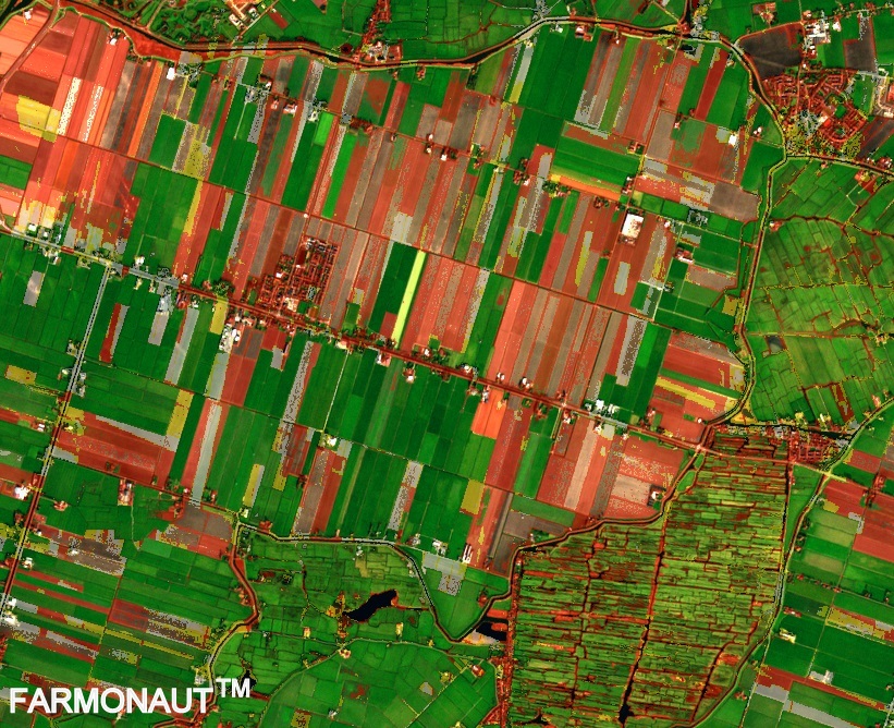
Normalized Difference Vegetation Index – NDVI
Normalized Difference Vegetation Index – NDVI It has been quite

Remote Sensing Blogs
Remote Sensing Blogs Normalized Difference Vegetation Index – NDVI It


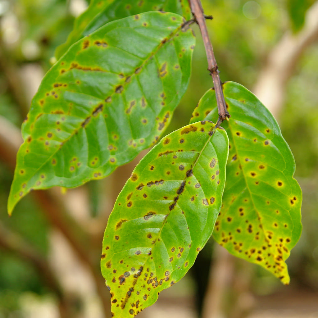
Achaea Janata – Castor Semi-looper
Achaea Janata – Castor Semilooper Castor Semilooper (achaea janata) is

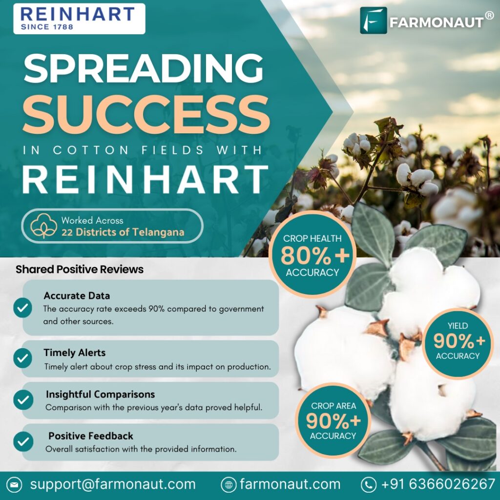
Spreading Success in Cotton Fields with REINHART
Friday, 23 Feb 2024 SPREADING SUCCESS IN COTTON FIELDS WITH

AI Based Farm Boundary Detection System
Effortless Field Mapping with FARMONAUT’S AI BOUNDARY DETECTION Lead the


Farmonaut’s Technologies: A Key Player in Crop Production Loss Prevention
Farmonaut’s Technology: A Key Player in Crop Production Loss Prevention

Bridging Horizons: Farmonaut’s CEO Ankur Omar Visits Troforte Innovations Pty Ltd
In the realm of agriculture, the fusion of innovation and

AI Based Farm Boundary Detection System
Thursday, 21 March 2024 Effortless Field Mapping with FARMONAUT’S AI
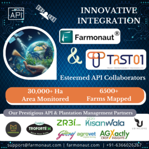
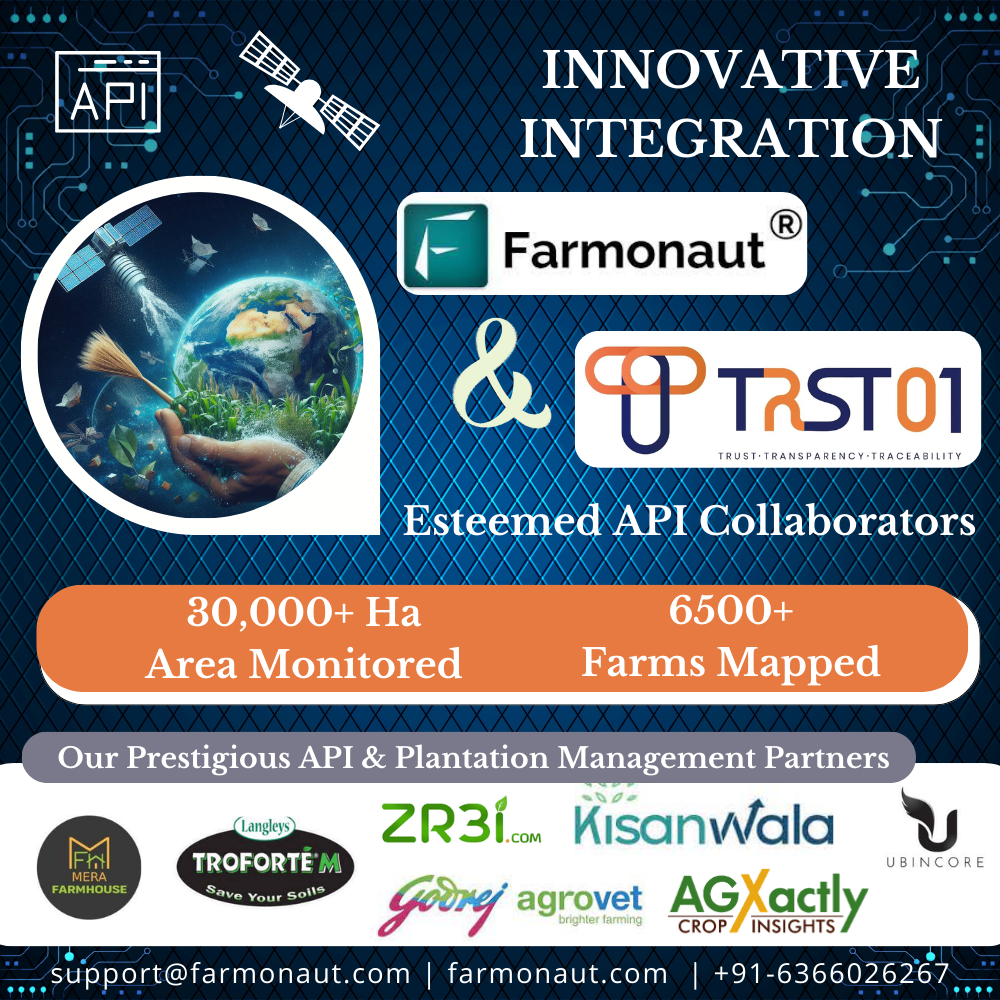
Farmonaut Thrives as a Valued API Collaborator
TRST01, a company founded in 2019 and based in Madhapur,
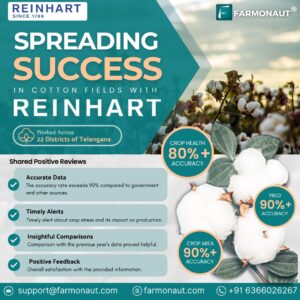
Spreading Success in Cotton Fields with REINHART
Friday, 23 Feb 2024 SPREADING SUCCESS IN COTTON FIELDS WITH

Enhancing Precision Agriculture: Farmonaut’s Impact on Boosting Sugarcane Yields
Introduction Sugarcane, a tall, perennial grass of the genus Saccharum,

Automated Whatsapp based Satellite Advisory in 2 mins
WHATSAPP BASED SATELLITE ADVISORY IN 2 MINS Farmonaut’s WhatsApp-Based Satellite

A leap into the future with GIS and AI towards Banana Farming: Farmonaut
In a remarkable stride towards agricultural advancement, the Farmers’ Training

Farmonaut shines at IMC 2023 (Indian Mobile Congress)
FARMONAUT SHINES AT IMC 2023 Farmonaut, a pioneer in agricultural

Explore Farmonaut’s Fleet Management System with Shivani Dudhatra
Hi Shivani! Could you please throw a light on what
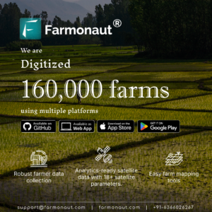
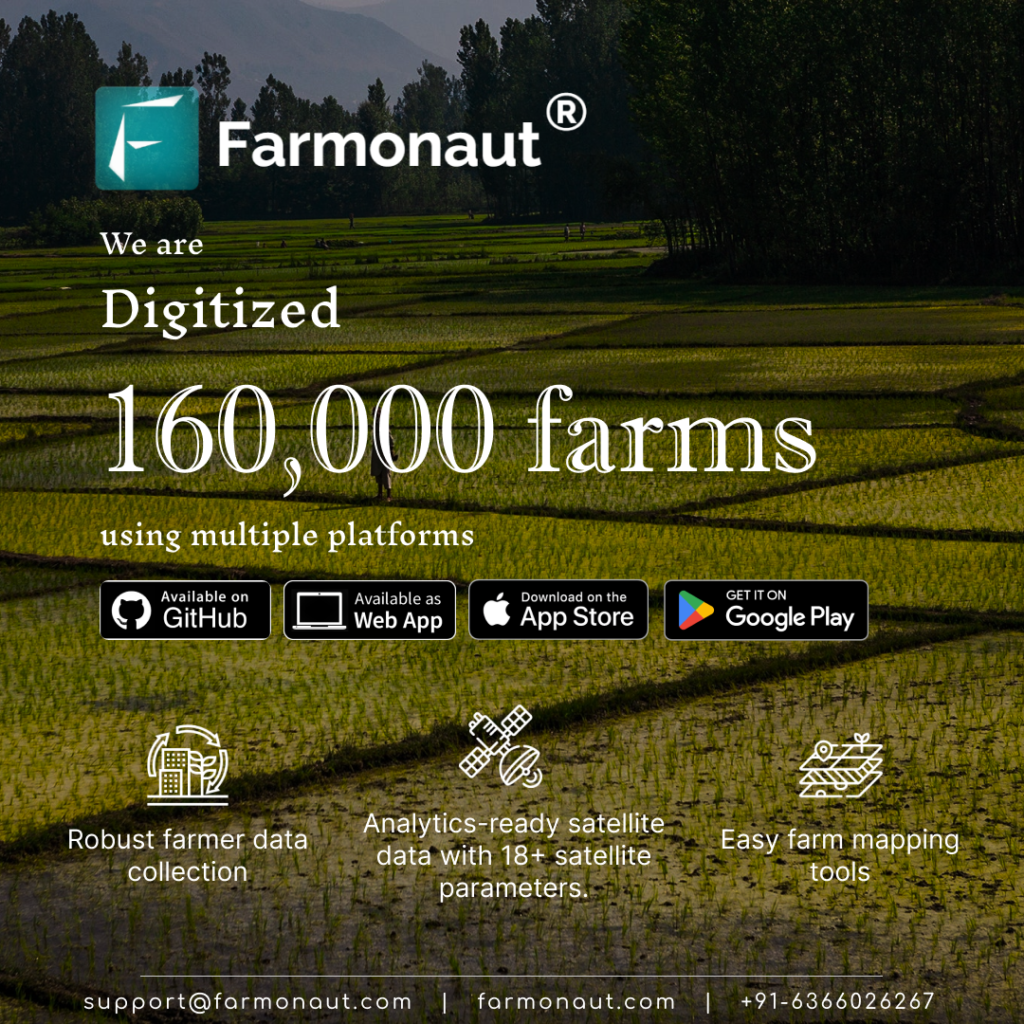
Farmonaut Digitized over 160,000 farms
SATELLITE ANALYTICS GEO-TAGGING FARMER DATA COLLECTION For the past two
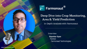
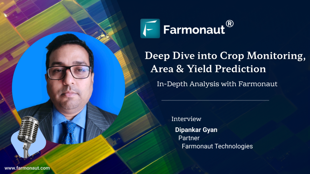
Deep Dive into Crop Monitoring, Area & Yield Estimation with Farmonaut’s Partner Mr.Dipankar Gyan
Hi Dipankar ji! Can you throw some light on fundamental

Farmonaut’s Task Management System: Streamlining communication for organizations
Farmonaut’s Task Management System Introduction This case study examines how
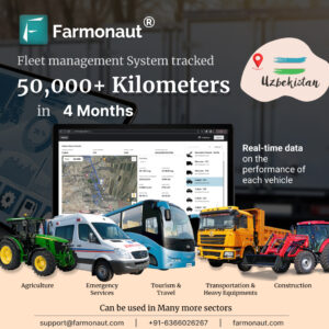
Driving Efficiency: Farmonaut’s Fleet Management System Redefines Operations
Driving efficiency by Farmonaut’s Fleet Management System FARMONAUT’S FLEET MANAGEMENT
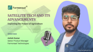
Farmonaut’s Satellite Tech and its Advancements with Ashish Kumar
1) Hi Ashish! Can you provide an overview of how
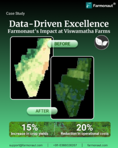
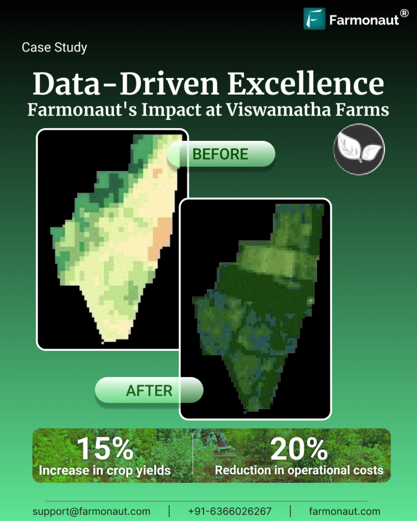
Data Driven Excellence: Farmonaut’s Impact at Viswamatha Farms
In the heartland of Andhra Pradesh, South India, where agriculture

CASE STUDY : How textile & fashion businesses can be benefitted from Farmonaut’s blockchain based traceability product?
INTRODUCTION In this technology-driven world, an affordable and reliable traceability

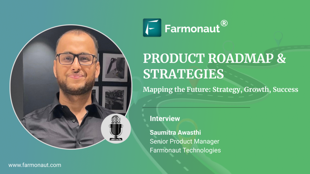
Farmonaut’s Product Roadmap & Strategies
Hi, Mr Saumitra , as the Senior product manager of
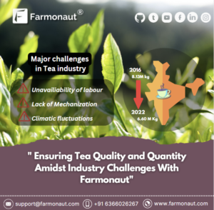
Farmonaut, Ensures Tea Quality and Quantity Amidst Industry Challenges.
INTRODUCTION The global tea industry is known for its rich

Rising trends on Carbon market, Carbon management & foot-printing
In an era marked by environmental consciousness and responsible business

Case Study – Wheat Area Estimation by Farmonaut in EGYPT
WHEAT AREA ESTIMATION Farmonaut’s area estimation results align with official
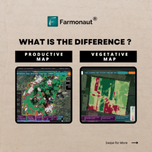
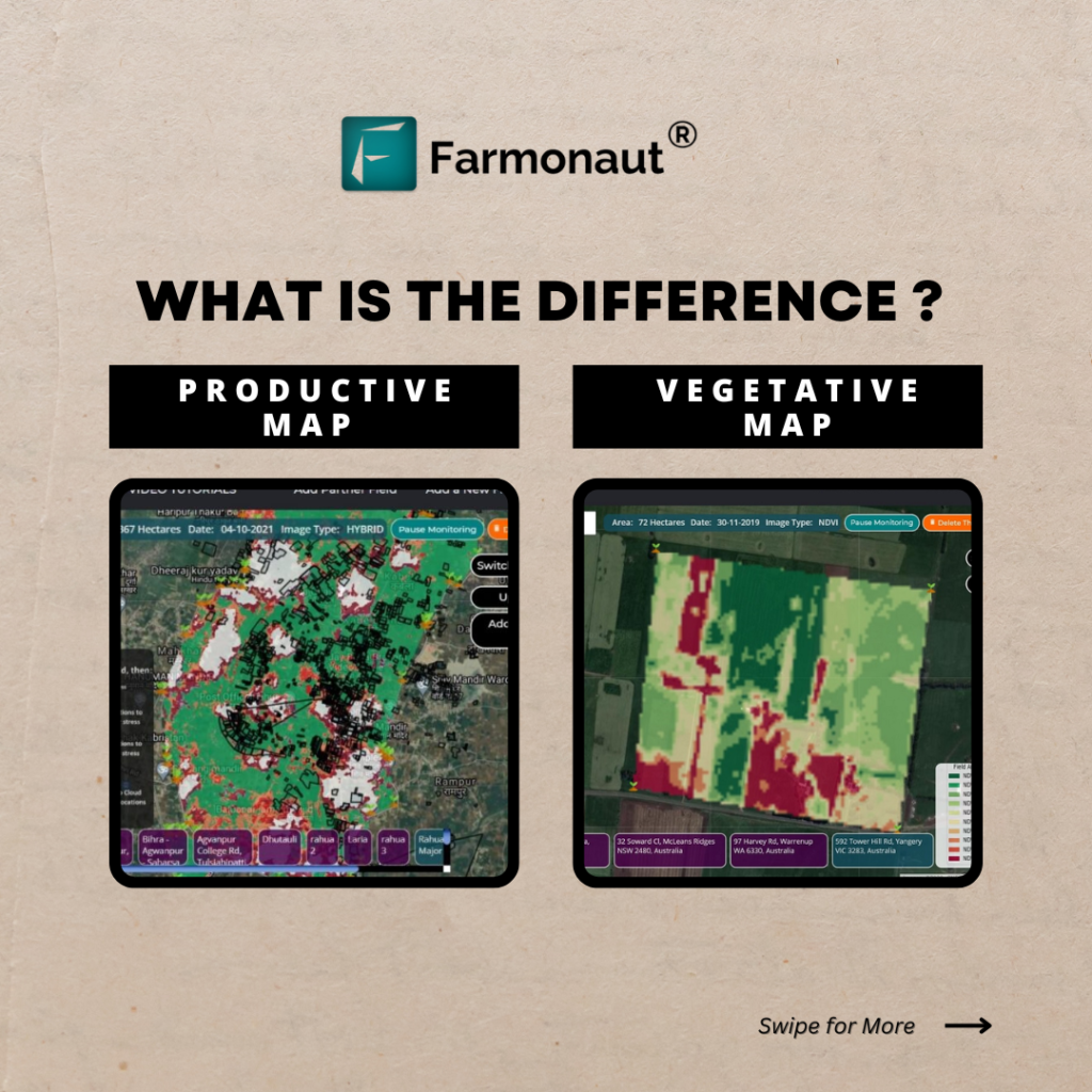
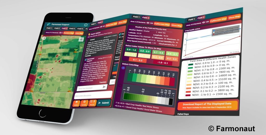
Vegetative Map and Productive Map
Precision agriculture is the use of technology to manage crops

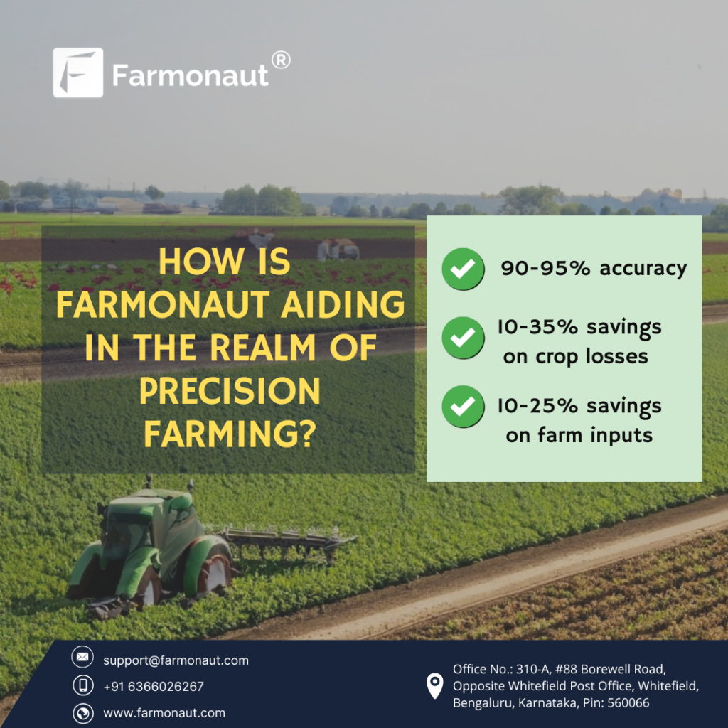
How Is Farmonaut Aiding In The Realm Of Precision Farming?
INTRODUCTION Precision farming entails the strategic integration of advanced technologies,
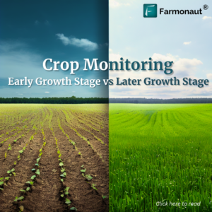
Crop monitoring: Early Growth Stage vs Later Growth Stage
Crop Monitoring at Early Growth Stage Crop monitoring at the

FARMONAUT’S Business Growth Strategies & Roadmap 2023
Defenitely, as the CEO of Farmonaut Technologies, I am excited
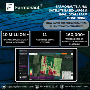
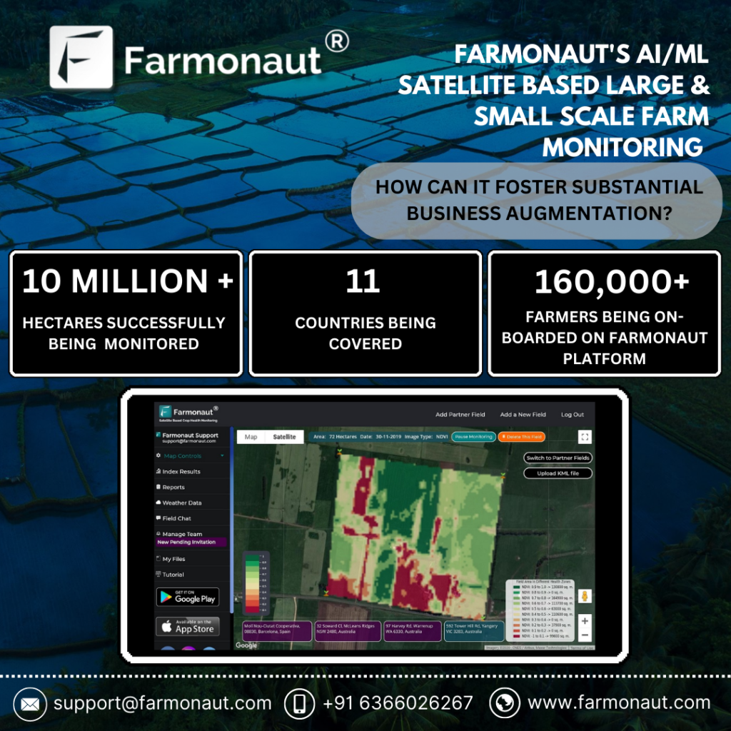
How can Farmonaut’s AI/ML Satellite-based Large Scale Farm and Small Scale Farm Monitoring serve businesses?
INTRODUCTION Agriculture is one of the world’s most important industries,

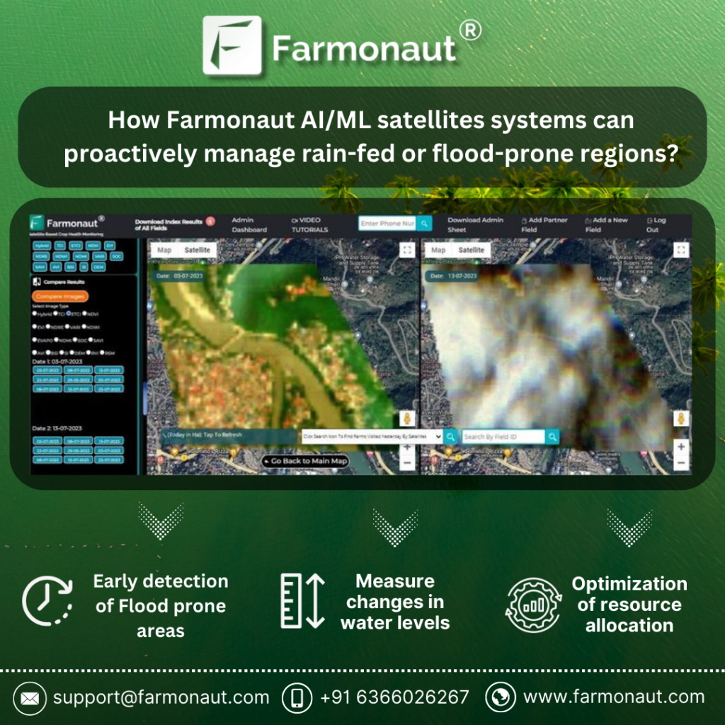
How Farmonaut AI/ML Satellites Systems Can Proactively Manage Rain-fed or Flood-prone Regions?
Floods are one of the most ubiquitous and pernicious natural
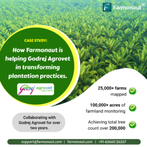
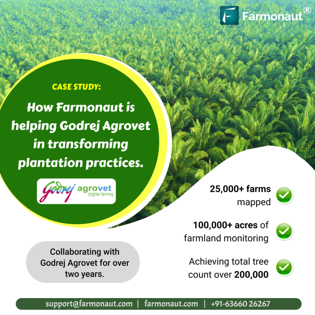
How Farmonaut Transformed Plantation Practices: A Case Study with Godrej Agrovet
Introduction This case study explores the successful partnership between Godrej
Geotag Farms at Large Scale with Farmonaut
Geotag Farms at Large Scale with Farmonaut Geotagging refers to

Farmonaut Admin App Tutorial
The following document gives a brief overview about various functions available on the Farmonaut Admin app.

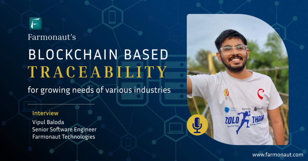
Farmonaut’s Blockchain based Traceability for growing needs of various industries
Blockchain based Traceability: Mission & Vision 2023 At Farmonaut, our
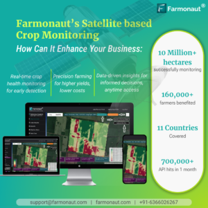
Farmonaut’s Satellite based Crop Monitoring: How can it enhance your business?
Farmonaut’s Satellite based Crop Monitoring: Optimizes farming with satellite data

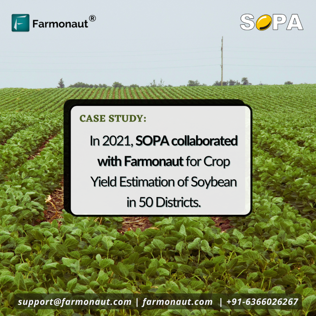
Case Study: SOPA Collaborated with Farmonaut for Crop Yield Estimation of Soybean in 50 Districts
Introduction Farmonaut, a leading agricultural technology company, partnered with the

Team Farmonaut® Embarks on G20 Conference with Unyielding Preparedness.
Team Farmonaut® Embarks on G20 Conference The G20, also known