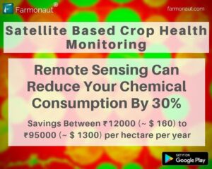
From Excess to Efficiency: How Farmonaut’s Remote Sensing Slashes Fertilizer Costs for Indian Farmers
In 2016, fertilizer consumption for India was 165.8 kilograms per hectare. Fertilizer consumption of India increased from 100.3 kilograms per hectare in 2002 to 165.8 kilograms per hectare in 2016 growing at an average annual rate of 3.81 %.
What is fertilizer consumption?
Fertilizer consumption measures the quantity of plant nutrients used per unit of arable land. Fertilizer products cover nitrogenous, potash, and phosphate fertilizers (including round rock phosphate). Traditional nutrients–animal and plant manures–are not included. The chemical price can vary from 250 rupees to 2000 rupees per kg depending upon the specific chemical being used. So on an average an Indian farmer spends between 41500 to 332000 rupees per year on each hectare of arable land.
Farmonaut identifies those areas of land where the crop growth is not normal. Farmer can apply fertilizers, chemicals, insecticides, pesticides, plant growth regulators etc. only in those areas where the crop growth is not normal. By using remote sensing results provided by Farmonaut, a farmer can save at least 30% on chemical consumption per year.
So for every one hectare of land, farmer can save at least between 12000 (~ $160) and 95000 (~ $1300) rupees per year.#farming #organicfarming #crops #urbanfarming #precisionagriculture #agro #farm #agritech #vegetables #agriculture #foodsecurity #technology #greentech #satellite #vegetation #india #gis#horticulture #research #tech #remotesensing #crophealth #crops
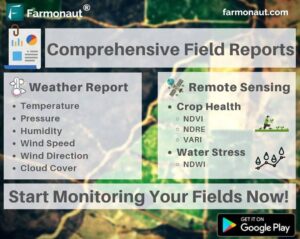
Revolutionizing Farming: Farmonaut’s New Automated Field Reports Bring Space-Age Insights to Your Inbox
At Farmonaut, we had been helping farmers identify unhealthy crop regions and water stress in their fields through satellite imagery. Now farmers will also receive comprehensive field reports of their agricultural land whenever the satellite crosses their location. This report will consist of:
A. Remote sensing data which will consist of continuous analysis of crop health (NDVI, NDRE, VARI) and water stress (NDWI) through tables, graphs, color maps etc.
B. Continuous weather data through which farmer can identify how is their field performing with different weather parameters.
These reports will be automatically sent to the email ID of the farmer as well as can be directly downloaded through the app.
Update your app now to access this new feature.
Happy Farming!
#precisionagriculture #organicfarming #fieldreport #analysis #research #greentech #technology #tech #foodsecurity #nasa #esa #spacex #remotesensing #gis #earth #farming #farm #harvest #agriculture #satellite #crophealth #fruit #vegetables #crops #agritech
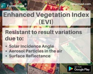
Revolutionizing Crop Health Monitoring: Farmonaut Introduces EVI for Enhanced Precision Farming
Farmonaut has been at the forefront of providing satellite based crop health monitoring services to farmers. We keep upon adding useful features for farmers to make their farming practices much accurate. Today, we have integrated EVI results into our system which can be accessed through our android app.
Even though NDVI results are pretty accurate in estimating crop health status of a field, there are still a few shortcomings (atmospheric and ground level) which can influence the field results.
The Enhanced Vegetation Index (EVI) uses additional wavelengths of light to correct for the inaccuracies of NDVI. Variations in solar incidence angle, atmospheric conditions like distortions in the reflected light caused by the particles in the air, and signals from the ground cover below the vegetation are corrected for using EVI.
Select your field for satellite monitoring on the app and start receiving EVI results with the satellite data as well!
Happy Farming!
#evi #ndvi #ndwi #vegetation #soil #aerosol
#organicfarming #crops #urbanfarming #fieldscouting #remotesensing #consultant #agriconsultant #greentech #smartfarming #precisionagriculture #farm #agritech #vegetables #agriculture #foodsecurity #technology #satellite #india #gis #waterstress #advisor #cropyield
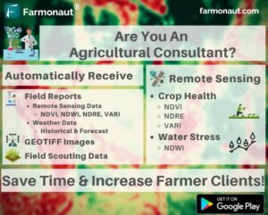
Revolutionize Your Agri-Consulting: Automate Field Monitoring with Farmonaut
Managing multiple farmer portfolios and generating results (Remote sensing data, weather data, precision agriculture analysis, GEOTIFF images) for them can be time consuming. Not only it limits the number of farmers you can serve but also the amount of money you spend on generating these results through third-party services. Why not automate this entire process and receive all these results automatically whenever the new data is available. By automating this entire process through Farmonaut, you can save time, money as well as can increase your farming clientele multifolds. Download the app now and start monitoring fields of your farmers! For any queries contact us on: [email protected]
#farming #organicfarming #crops #urbanfarming #fieldscouting #remotesensing #consultant #agriconsultant #greentech #smartfarming #precisionagriculture #farm #agritech #vegetables #agriculture #foodsecurity #technology #satellite #vegetation #india #gis #waterstress #advisor #cropyield
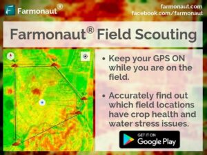
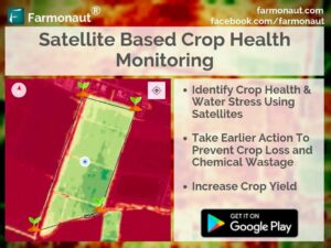
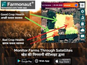
Satellite-Powered Field Scouting: Revolutionizing Crop Health Management with Farmonaut
Farmonaut matches the user location with satellite coordinates and shows unhealthy vegetation of the field and water stress condition in red and yellow. Upon identifying these regions of the fields, farmers can simply pay a visit to that part of the field and identify if the problem has already started. If it has not, the farmer can take preventive remedies by applying more fertilizers, plant growth regulators, improving irrigation etc. Farmonaut strives to bring state of the art technologies in the grasp of every farmer, and will continue adding more features in the coming days. ☺️ Happy Farming!! 🌱🌾👩🌾 #farming #organicfarming #crops #urbanfarming #fieldscouting #smartfarming #precisionagriculture #agro #agrotech #farm #agritech #vegetables #agriculture #foodsecurity #technology #greentech #satellite #vegetation #india #gis
Revolutionize Your Farm: Unlock the Power of Satellite-Driven Agriculture with Farmonaut®
Download Farmonaut® and be a part of the growing technology driven farming community. With Farmonaut you get: • Satellite Based Crop Monitoring
• Automated Crop Monitoring
• Crop Health Status
• Vegetation Water Level
• Farmers’ Discussion Forum/ Social Network
• Voice-Text Based Plant Issue Identification (50+ Languages Supported)
• Govt. Approved Farming Database (100+ Crops, 300+ Diseases)
• Crop Registration System
• Satellite Imagery Access For Research
and much more..!! #farming #organicfarming #crops #urbanfarming #fieldscouting #remotesensing #consultant #agriconsultant #greentech #smartfarming #precisionagriculture #farm #agritech #vegetables #agriculture #foodsecurity #technology #satellite #vegetation #india #gis #waterstress #advisor #cropyield
Revolutionizing Indian Agriculture: How Farmonaut’s Remote Sensing Can Save Farmers Thousands on Fertilizers
In 2016, fertilizer consumption for India was 165.8 kilograms per hectare. Fertilizer consumption of India increased from 100.3 kilograms per hectare in 2002 to 165.8 kilograms per hectare in 2016 growing at an average annual rate of 3.81 %.
The chemical price can vary from 250 rupees to 2000 rupees per kg depending upon the specific chemical being used. So on an average an Indian farmer spends between 41500 to 332000 rupees per year on each hectare of arable land.
Farmonaut identifies those areas of land where the crop growth is not normal. Farmer can apply fertilizers, chemicals, insecticides, pesticides, plant growth regulators etc. only in
those areas where the crop growth is not normal. By using
remote sensing results provided by Farmonaut, a farmer can save at least 30% on chemical consumption per year.
So for every one hectare of land, farmer can save at least between 12000 (~ $160) and 95000 (~ $1300) rupees per year.
The app is available on Google Play Store. Happy Farming!
#farming #organicfarming #crops #urbanfarming #fieldscouting #remotesensing #greentech #smartfarming #precisionagriculture #agro #agrotech #farm #agritech #vegetables #agriculture #foodsecurity #technology #satellite #vegetation #india #gis
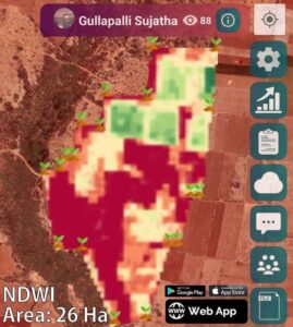
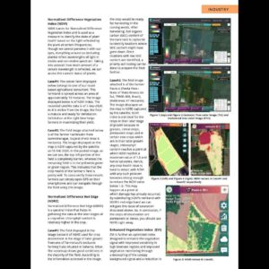
Unlocking Field Potential: Decoding NDWI for Smart Irrigation and Crop Health
PrecisionAg101 Post #2 : These posts are meant to make farmers aware of the basics of precision agriculture and how to interpret various satellite data provided by us.
The field image attached below is of the farmer Gullapalli Sujatha (Viswamatha farms, Andhra Pradesh, one of the pioneers in Natural Farming in India), (Field Area: 26 Hectares). The image displayed on the map is NDWI (Normalized Difference Water Index) captured by the satellite. NDWI images are used to quantify water stress in the vegetation in a field. NDWI index can help us control irrigation, significantly improving agriculture, especially in areas where meeting the need for water is difficult. The colors used to quantify this information is very easy to interpret.
Dark Green/ Green: water stress is good
Yellow: irrigation may need attention
Red: Barren land/ no vegetation
In the posted image, as we can see, the top portion of the field shows pretty good water stress in the vegetation, whereas the remaining field is in the yellowish or red region. This indicates that the farmer needs to pay attention to irrigation in these highlighted regions. To cross-verify these results farmers can simply open GPS on their smartphones and can navigate through the field using this image.
By using satellite data provided by us, farmers can:
1. Reduce Chemical/Fertilizer consumption by applying them only in the locations where crop
health is not good.
2. Reduce Labour costs by directing the labours only in those field areas where crop health is
critical.
3. Reduce irrigation water wastage by applying proper irrigation only in those locations where
plant water stress is low.
4. Increase overall yield.
The system is available for use on android, iOS as well as web.
Happy Farming!
#farming #organicfarming #crops #urbanfarming #ndwi #waterstress #fieldscouting #remotesensing #consultant #agriconsultant #greentech #smartfarming #precisionagriculture #farm #agritech #agriculture #foodsecurity #technology #satellite #vegetation #india #gis #waterstress #advisor #cropyield
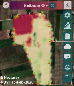
Unlocking the Power of Precision Agriculture: A Beginner’s Guide to Satellite-Driven Farming
PrecisionAg101 Post #1 : Starting today, we will be releasing posts regularly to make farmers aware of the basics of precision agriculture and how to interpret various satellite data provided by us.
The field image attached below is of the farmer Harikrushn from Surendranagar, Gujarat (Field Area: 6 Hectares). The image displayed on the map is NDVI (Normalized Difference Vegetation Index) captured by the satellite on 15 Feb 2020. NDVI images are used to quantify crop health status in a field. The colors used to quantify this information is very easy to interpret.
Dark Green/ Green: Crop is very healthy
Yellow: Crop needs attention
Red: Barren land
In the posted image, as we can see, the top left portion of the field is completely barren, whereas the remaining field is in the yellowish green or green region. This indicates that the crop health of the farmer’s field is pretty well. To cross-verify these results farmers can simply open GPS on their smartphones and can navigate through the field using this image.
By using satellite data provided by us, farmers can:
1. Reduce Chemical/Fertilizer consumption by applying them only in the locations where crop
health is not good.
2. Reduce Labour costs by directing the labours only in those field areas where crop health is
critical.
3. Reduce irrigation water wastage by applying proper irrigation only in those locations where
plant water stress is low.
4. Increase overall yield.
The system is available for use on android, iOS as well as web.
Happy Farming!
#farming #organicfarming #crops #urbanfarming #ndvi #fieldscouting #remotesensing #consultant #agriconsultant #greentech #smartfarming #precisionagriculture #farm #agritech #agriculture #foodsecurity #technology #satellite #vegetation #india #gis #waterstress #advisor #cropyield
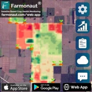
Revolutionize Your Farm Management: Farmonaut’s Time-Lapse Crop Monitoring at Your Fingertips
While Monitoring the farms, very often it is essential for a farmer to track how their field ‘s crop health and water stress has changed with time using a timelapse. Farmonaut’s Satellite Based Crop Health Monitoring System generates timelapse of the field data on-the-go with just a few clicks and overlays the timelapse on the map itself. Start monitoring your fields through Farmonaut and start receiving satellite results right away!
Happy Farming!
#timelapse #webapp #farmer #farming #satellite #vegetation #gis #organicfarming #crops #urbanfarming #fieldscouting #remotesensing #greentech #smartfarming #precisionagriculture #agro #farm #agritech #vegetables #agriculture #foodsecurity #technology
Revolutionizing Agriculture: Farmonaut’s Affordable Satellite Crop Monitoring for Every Farmer
Farmonaut’s Satellite Based Crop Health Monitoring System is built to put satellite technology in the hands of each and every farmer in the most economical way. Our objective is to break the cost barrier and help democratize remote sensing in the farming community by providing an on-the-go always ready platform for field monitoring through satellites. In an attempt to further our goal, we have introduced Farmonaut’s Satellite Based Crop Health Monitoring System for web usage as well. The system is also accessible through our android as well as iOS apps.
#webapp #farmer #farming #satellite #vegetation #gis #organicfarming #crops #urbanfarming #fieldscouting #remotesensing #android #ios #web #google #apple #iphone #appstore #playstore #greentech #smartfarming #precisionagriculture #agro #farm #agritech #vegetables #agriculture #foodsecurity #technology
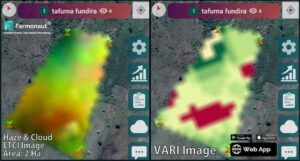
Unlocking Field Secrets: Decoding ETCI and VARI for Smarter Farming
PrecisionAg101 Post #3 : These posts are meant to make farmers aware of the basics of precision agriculture and how to interpret various satellite data provided by us.
The field image attached below is of the farmer Tafuma Fundira (Masvingo, Zimbabwe), (Field Area: 2 Hectares). The image displayed on the map is ETCI (Enhanced True Color Image) on the left and VARI (Visible Atmospherically Resistant Index) image on the right. ETCI stands for Enhanced True Color Image. It is basically a TCI image processed by our own systems to enhance the land features which were not so explicitly visible in the raw TCI Image. VARI stands for Visible Atmospherically Resistant Index. VARI is minimally resistant to atmospheric effects, allowing vegetation to be estimated in a wide variety of environment. Hence, it is ideally recommended to be used for farm level decision making if TCI and ETCI images show visible atmospheric distortion such as mild clouds or haze above the field. The colors used to quantify this information is very easy to interpret.
Dark Green/ Green: Crop is very healthy
Yellow: Crop needs attention
Red: Barren land
In the posted image, as we can see, the ETCI image seems to be distorted due to haze and clouds. In such cases vegetation indices like NDVI will not give correct observations. Thus, VARI is used in such cases. As we can see through the VARI image, a majority of the field is growing pretty well, with some barren regions shown in red. To cross-verify these results farmers can simply open GPS on their smartphones and can navigate through the field using this image.
By using satellite data provided by us, farmers can:
1. Reduce Chemical/Fertilizer consumption by applying them only in the locations where crop health is not good.
2. Reduce Labour costs by directing the labours only in those field areas where crop health is critical.
3. Reduce irrigation water wastage by applying proper irrigation only in those locations where plant water stress is low.
4. Increase overall yield.
The system is available for use on android, iOS as well as web.
Happy Farming!
#farming #organicfarming #crops #urbanfarming #vari #crophealth #fieldscouting #remotesensing
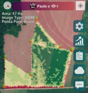
Unlocking Crop Health Secrets: Mastering NDRE for Advanced Precision Agriculture
PrecisionAg101 Post #4 : These posts are meant to make farmers aware of the basics of precision agriculture and how to interpret various satellite data provided by us.
The field image attached below is of the farmer Paulo o (Ponta Pora – State of Mato Grosso do Sul, 79900-000, Brazil), (Field Area: 47 Hectares). The image displayed on the map is NDRE (Normalized Difference Red Edge) captured by the satellite. NDRE images are used to quantify crop health when the crop is in the later stage of growth. NDVI index is not ideal for the crops in their later stage of growth because in grasses, cereal crops, permanent crops and in certain row crops which are in their later growth stages, chlorophyll content reaches a point at which NDVI reaches a maximum value of 1.0 and hence saturates. Hence, any crop health issue is hard to detect with NDVI until any such problem becomes strong enough to reduce the NDVI value below 1.0. This may happen at a point at which damage has already occurred. By substituting NDVI’s red band with NDRE’s red edge band we can mitigate this issue of saturation discussed above. So, in conclusion, if the crops of observation are permanent or dense, you should use NDRE right away. The colors used to quantify this information is very easy to interpret.
Dark Green/ Green: Crop is very healthy
Yellow: Crop needs attention
Red: Barren land
To cross-verify these results farmers can simply open GPS on their smartphones and can navigate through the field using this image.
By using satellite data provided by us, farmers can:
1. Reduce Chemical/Fertilizer consumption by applying them only in the locations where crop
health is not good.
2. Reduce Labour costs by directing the labours only in those field areas where crop health is
critical.
3. Reduce irrigation water wastage by applying proper irrigation only in those locations where
plant water stress is low.
4. Increase overall yield.
The system is available for use on android, iOS as well as web.
Happy Farming!
#farming #organicfarming #crops #urbanfarming #ndre #rededge #crophealth #fieldscouting #remotesensing #consultant #agriconsultant #greentech #smartfarming #precisionagriculture #farm
Farmonaut: Empowering Progressive Farmers with Cutting-Edge Agritech Solutions
(Available on android, iOS and website) Farmonaut is a hub for the PROGRESSIVE FARMERS. If you are a farmer and someone who is bringing change in the farming community then Farmonaut is your place to be!
Farmonaut is bringing state-of-the-art technologies in the hands of each and every farmer. Be it:
• Satellite Based Crop Health Monitoring (Crop Health and Water Stress)
• Farmers’ own Social Network
• Voice-Text Based Plant Issue Identification (50+ Languages Supported)
• Govt. Approved Farming Database (100+ Crops, 300+ Diseases)
• Crop Registration System
and what not, you get it all on Farmonaut!
Farmonaut is available on android, iOS as well as a web-app!
#farming #organicfarming #crops #urbanfarming #fieldscouting #remotesensing #agriconsultant #greentech #smartfarming #precisionagriculture #farm #agritech #agriculture #foodsecurity #technology #satellite #vegetation #india #gis #waterstress #advisor #cropyield #socialnetwork
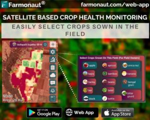
Revolutionizing Crop Monitoring: Farmonaut’s New Crop Selection Feature Empowers Farmers
Our objective at Farmonaut is to keep ideating and adding more features to the platform which will be useful for the farming community. In our attempt to take our platform one step further, we have added a new functionality to our satellite based crop health monitoring system. Farmers can mention the crops sown in their fields with very much ease now through the in-built crops list. This will be useful for the farmer as well as Farmonaut for conducting in-depth precise analysis in future. We will keep on adding more new features to the platform in the coming days.
Happy Farming!
#farmer #farming #satellite #naturalfarming #vegetation #lowcost #gis #organicfarming #crops #urbanfarming #fieldscouting #remotesensing #greentech #smartfarming #precisionagriculture #agro #farm #agritech #vegetables #agriculture #foodsecurity #technology
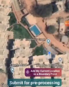
Walk, Map, Grow: Farmonaut’s New App Feature Empowers Small Farmers with Precision Field Mapping
(Video at 5x speed)
We are introducing several new features with the new update of our android app. Farmers can now walk around their field perimeter and select their current location as one of the field boundary points. This will help small and medium size farmers whose field location is not properly visible on the Google maps to demarcate their field accurately.
Happy Farming!
#farmer #farming #satellite #naturalfarming #vegetation #lowcost #gis #organicfarming #crops #urbanfarming #fieldscouting #remotesensing #greentech #smartfarming #precisionagriculture #agro #farm #agritech #vegetables #agriculture #foodsecurity #technology #androi
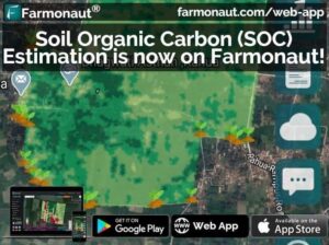
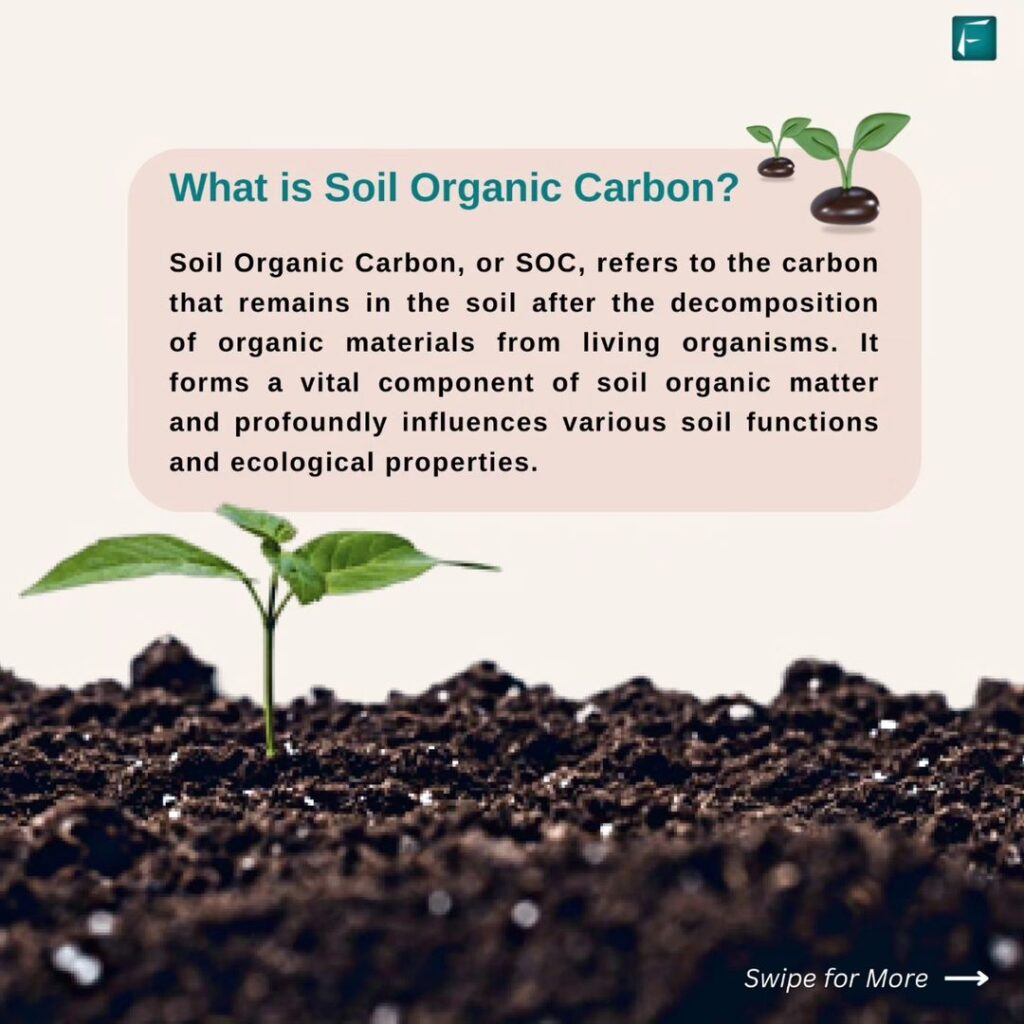
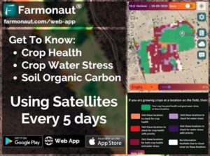
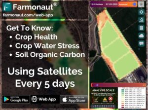
Revolutionizing Soil Health: Farmonaut Unveils Soil Organic Carbon Estimation Feature
Today, we are releasing Soil Organic Carbon Content Estimation in beta stage with our already offered crop health and vegetation water stress satellite data through our platforms.
Organic matter contributes to nutrient retention and turnover, soil structure, moisture retention, degradation of pollutants, carbon sequestration and soil resilience. Majority of the agricultural fields lose substantial organic matter post-harvest and once the new crop-cycle starts, if the SOC levels have not recovered, the crop yield may not be same for all the parts of the field. Hence, once our data has identified some locations to be having less SOC levels, farmers can get the soil testing done on those regions and add required nutrients to those regions to rejuvenate the soil organic matter levels. This will ultimately lead to better yields.
Update your app now and start using this new feature!
Happy farming!
#soil #soilhealth #soc #organicmatter #farming #organicfarming #crops #urbanfarming #fieldscouting #remotesensing #greentech #smartfarming #precisionagriculture #agro #agrotech #farm #agritech #vegetables #agriculture #foodsecurity #technology #greentech #satellite #vegetation #india #gis
Unlocking Soil Potential: How Organic Carbon Levels Impact Crop Yields and Field Health
Organic matter contributes to nutrient retention and turnover, soil structure, moisture retention, degradation of pollutants, carbon sequestration and soil resilience. Majority of the agricultural fields lose substantial organic matter post-harvest and once the new crop-cycle starts, if the SOC levels have not recovered, the crop yield may not be same for all the parts of the field. Hence, once our data has identified some locations to be having less SOC levels, farmers can get the soil testing done on those regions and add required nutrients to those regions to rejuvenate the soil organic matter levels. This will ultimately lead to better yields.
Soil Organic Carbon Content Estimation is in beta stage with our already offered crop health and vegetation water stress satellite data through our platforms. Start monitoring your fields now!
Happy farming!
#soil #soilhealth #soc #organicmatter #farming #organicfarming #crops #urbanfarming #fieldscouting #remotesensing #greentech #smartfarming #precisionagriculture #agro #agrotech #farm #agritech #vegetables #agriculture #foodsecurity #technology #greentech #satellite #vegetation #india #gis
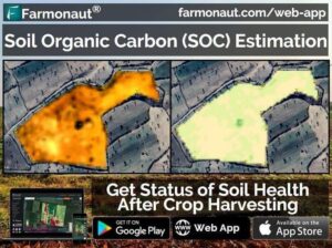
Unlock Field Performance Secrets: Farmonaut’s Post-Harvest Analysis for Smarter Farming
Once the cultivation is over, it is often necessary to identify how your field performed during the previous crop cycle. Farmonaut lets you do this analysis for various field factors and enables you to make method corrections for the next crop cycle. Farmonaut’s Satellite Based crop Health Monitoring platform is available on android, iOS as well as the website.
Happy Farming! #farming #organicfarming #crops #urbanfarming #fieldscouting #remotesensing #greentech #smartfarming #precisionagriculture #farm #agritech #agriculture #foodsecurity #technology #satellite #vegetation #india #gis #soil #soilhealth #soc #webapp #newfeature #organicmatter
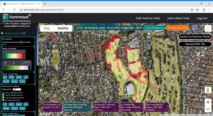
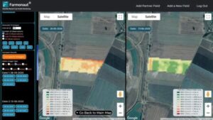
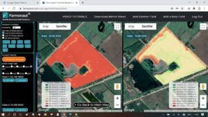
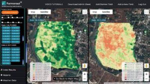
Time-Lapse Farming: Unveiling Field Growth with Farmonaut’s Side-by-Side Satellite Comparison
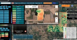
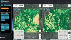
While Monitoring the farms, it is essential to observe how different parts of the field have shown growth changes through time to make better on-field decisions. This can be done through Farmonaut’s Web App by comparing two satellite images simultaneously. You can select any two dates of satellite visits and compare results side by side on the map of the Farmonaut web app itself. Try this out if you haven’t yet.
Happy Farming!
#webapp #newfeature #organicmatter #farming #organicfarming #crops #urbanfarming #fieldscouting #remotesensing #greentech #smartfarming #precisionagriculture #agro #agrotech #farm #agritech #vegetables #agriculture #foodsecurity #technology #greentech #satellite #vegetation #india #gis #soil #soilhealth #soc
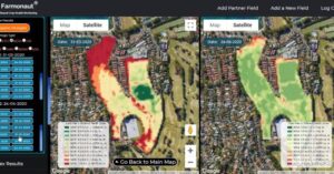
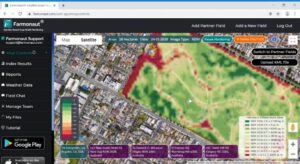
Unveiling Field Evolution: Farmonaut’s Side-by-Side Image Comparison Revolutionizes Farm Monitoring
NOW COMPARE FIELD IMAGES SIDE-BY-SIDE
While Monitoring the farms, you may want to observe changes in the field by comparing two images simultaneously. This is very easy to do with Farmonaut’s compare images option. You can select any two dates of satellite visits and compare results side by side on the map of the Farmonaut web app itself.
Happy Farming!
#webapp #newfeature #organicmatter #farming #organicfarming #crops #urbanfarming #fieldscouting #remotesensing #greentech #smartfarming #precisionagriculture #agro #agrotech #farm #agritech #vegetables #agriculture #foodsecurity #technology #greentech #satellite #vegetation #india #gis #soil #soilhealth #soc
Slash Fertilizer Costs by 30%: How Farmonaut’s Remote Sensing Tech Saves Indian Farmers Thousands
In 2016, fertilizer consumption for India was 165.8 kilograms per hectare. Fertilizer consumption of India increased from 100.3 kilograms per hectare in 2002 to 165.8 kilograms per hectare in 2016 growing at an average annual rate of 3.81 %.
The chemical price can vary from 250 rupees to 2000 rupees per kg depending upon the specific chemical being used. So on an average an Indian farmer spends between 41500 to 332000 rupees per year on each hectare of arable land.
Farmonaut identifies those areas of land where the crop growth is not normal. Farmer can apply fertilizers, chemicals, insecticides, pesticides, plant growth regulators etc. only in
those areas where the crop growth is not normal. By using
remote sensing results provided by Farmonaut, a farmer can save at least 30% on chemical consumption per year.
So for every one hectare of land, farmer can save at least between 12000 (~ $160) and 95000 (~ $1300) rupees per year.
The app is available on Google Play Store, Apple App Store as well as a Web App on our website. Happy Farming!
#farming #organicfarming #crops #urbanfarming #fieldscouting #remotesensing #greentech #smartfarming #precisionagriculture #agro #agrotech #farm #agritech #vegetables #agriculture #foodsecurity #technology #satellite #vegetation #india #gis
Revolutionizing Agriculture: How Farmonaut’s Satellite Technology Empowers Farmers to Detect and Solve Crop Issues
Farmonaut matches the user location with satellite coordinates and fetches the latest imagery, and runs a series of image processing algorithms to deliver the best quality results to the farmers. The below image shows unhealthy vegetation in red and yellow. Upon identifying these regions of their fields, they can simply pay a visit to that part of the field and identify if the problem has already started. If it has not, the farmer can take preventive remedies by applying more fertilizers, plant growth regulators etc. If the problem has already started, they can simply explain their problem to Farmonaut’s crop issue identification system and get real-time govt. approved remedies. Apart from this, farmers also receive vegetation water stress and soil organic carbon data as well! Farmonaut strives to bring state of the art technologies in the grasp of every farmer, and will continue adding more features in the coming days. ☺️ Happy Farming!! 🌱🌾👩🌾 #farming #farm #harvest #agrotech #agriculture #satellite #crophealth #farmonaut #fruit #vegetables #crops #agro #agritech #precisionagriculture #organicfarming #greentech #technology #tech #foodsecurity #farmersofinstagram #farmerlife #urbanfarmer #urbanfarming #nasa #esa #spacex #remotesensing #gis #earth #earthfromabove
From Seed to Harvest: A 17-Day Satellite Journey Through Dr. Ratonyi’s Hungarian Field
This field is of one of our users Dr. Tamas Ratonyi from Hungary, Europe. The displayed field has an area of 5 Hectares. This is a side-by-side comparison of crop growth during a gap of 17 days captured by the satellites from 26th May, 2020 to 13th June, 2020. The data reveals that more than 3 hectares of land has already achieved maturity and is ready to be harvested. The remaining land is expected to achieve maturity in the next 7-10 days.
By having the crop maturity data, farmers can decide precisely when to harvest which region of their field so as to get the maximum yield.
The app is available on Google Play Store, Apple App Store as well as a Web App on our website
Happy Farming!
#soil #soilhealth #soc #organicmatter #farming #organicfarming #crops #urbanfarming #fieldscouting #remotesensing #greentech #smartfarming #precisionagriculture #agro #agrotech #farm #agritech #vegetables #agriculture #foodsecurity #technology #greentech #satellite #vegetation #india #gis

10,000 Strong: Farmonaut’s Digital Farming Revolution Reaches New Heights!
We are happy to announce that more than 10000 users are now on board the Farmonaut platform!! (android, iOS, and web app) Thanks a lot for your support! We will keep pushing hard to bring more innovation in the farming sector. Stay tuned!!
Happy Farming!! 🙂
#farming #organicfarming #crops #urbanfarming #fieldscouting #remotesensing #android #ios #apple #iphone #ipad #appstore #playstore #greentech #smartfarming #precisionagriculture #agro #agrotech #farm #agritech #vegetables #agriculture #foodsecurity #technology #satellite #vegetation #india #gis
Revolutionizing Farm Management: Satellite-Powered Crop Health and Water Stress Monitoring
Did you know that through satellites you can monitor and manage crop health and water stress on your farm? Read more about Farmonaut in this latest article. Let us know in the comment box below how you manage crop health and water stress on your farm.
Link in bio.
क्या आप जानते हैं कि उपग्रहों के माध्यम से आप अपने खेत पर फसल के स्वास्थ्य और पानी के तनाव की निगरानी और प्रबंधन कर सकते हैं? इस नवीनतम लेख में फार्मोनॉट के बारे में और पढ़ें। नीचे दिए गए कमेंट बॉक्स में हमें बताएं कि आप अपने खेत में फसल स्वास्थ्य और पानी के तनाव का प्रबंधन कैसे करते हैं।
#techsamvadnews #company #farming #organicfarming #crops #urbanfarming #fieldscouting #remotesensing #greentech #smartfarming #precisionagriculture #agro #agrotech #farm #agritech #vegetables #agriculture #foodsecurity #technology #satellite #vegetation #india #gis
Revolutionizing Indian Agriculture: How Farmonaut’s Remote Sensing Technology Saves Farmers Thousands on Fertilizers
In 2016, fertilizer consumption for India was 165.8 kilograms per hectare. Fertilizer consumption of India increased from 100.3 kilograms per hectare in 2002 to 165.8 kilograms per hectare in 2016 growing at an average annual rate of 3.81 %.
The chemical price can vary from 250 rupees to 2000 rupees per kg depending upon the specific chemical being used. So on an average an Indian farmer spends between 41500 to 332000 rupees per year on each hectare of arable land.
Farmonaut identifies those areas of land where the crop growth is not normal. Farmer can apply fertilizers, chemicals, insecticides, pesticides, plant growth regulators etc. only in
those areas where the crop growth is not normal. By using
remote sensing results provided by Farmonaut, a farmer can save at least 30% on chemical consumption per year.
So for every one hectare of land, farmer can save at least between 12000 (~ $160) and 95000 (~ $1300) rupees per year.
Apart from this, farmers also receive vegetation water stress and soil organic carbon data as well! Farmonaut strives to bring state of the art technologies in the grasp of every farmer, and will continue adding more features in the coming days. ☺️ Happy Farming!!
The app is available on Google Play Store, Apple App Store as well as a Web App on our website. Happy Farming!
#farming #organicfarming #crops #urbanfarming #fieldscouting #remotesensing #greentech #smartfarming #precisionagriculture #agro #agrotech #farm #agritech #vegetables #agriculture #foodsecurity #technology #satellite #vegetation #india #gis
Revolutionize Your Farming: Farmonaut’s New Android App Update Brings Simplified, Enhanced User Experience
come and get a more enhanced user experience on our newly released simplified landing screen of our android app Update your app now!
Happy Farming!
The app is available on Google Play Store, Apple App Store as well as a Web App on our website.
#farming #organicfarming #crops #urbanfarming #fieldscouting #remotesensing #greentech #smartfarming #precisionagriculture #agro #agrotech #farm #agritech #vegetables #agriculture #foodsecurity #technology #satellite #vegetation #india #gis
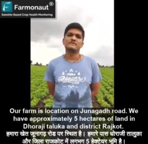
From Field to Phone: Gujarat Farmer’s Success with Farmonaut’s Satellite-Powered Crop Management
A video testimonial from Ashish Vaishnav from Dhoraji, Rajkot (Gujarat) who has been using Farmonaut since last 2 months.
Using Farmonaut, farmers can select their field and identify the regions of the field at which the crop growth is not normal. Upon identifying these regions of their fields, they can simply pay a visit to those parts of the field and identify if the problem has already started. If it has not, the farmer can take preventive remedies by applying more fertilizers, plant growth regulators etc. If the problem has already started, they can simply explain their problem to Farmonaut’s crop issue identification system and get real-time govt. approved remedies.
The satellite imagery is updated every 3-5 days and has a resolution of 10 meters. Apart from this, farmers also receive vegetation water stress and soil organic carbon data as well!
#farming #farm #harvest #agrotech #agriculture #satellite #crophealth #farmonaut #fruit #vegetables #crops #agro #agritech #precisionagriculture #organicfarming #greentech #technology #tech #foodsecurity #farmersofinstagram #farmerlife #urbanfarmer #urbanfarming #nasa #esa #spacex #remotesensing #gis #earth #earthfromabove
From Cotton Fields to Space: Gujarat Farmer’s Farmonaut Success Story
A video testimonial from Prashant Amitbhai Hirapara from Dhoraji, Rajkot (Gujarat) who has been using Farmonaut since last 1 month. He is cultivating cotton in his farm.
Using Farmonaut, farmers can select their field and identify the regions of the field at which the crop growth is not normal. Upon identifying these regions of their fields, they can simply pay a visit to those parts of the field and identify if the problem has already started. If it has not, the farmer can take preventive remedies by applying more fertilizers, plant growth regulators etc. If the problem has already started, they can simply explain their problem to Farmonaut’s crop issue identification system and get real-time govt. approved remedies.
The satellite imagery is updated every 3-5 days and has a resolution of 10 meters. Apart from this, farmers also receive vegetation water stress and soil organic carbon data as well!
#farming #farm #harvest #agrotech #agriculture #satellite #crophealth #farmonaut #fruit #vegetables #crops #agro #agritech #precisionagriculture #organicfarming #greentech #technology #tech #foodsecurity #farmersofinstagram #farmerlife #urbanfarmer #urbanfarming #nasa #esa #spacex #remotesensing #gis #earth #earthfromabove
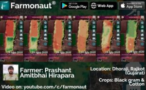
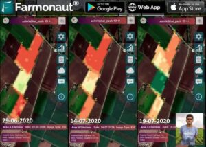
Satellite Insights: How Farmonaut Helped a Gujarat Farmer Monitor Blackgram and Cotton Crops
The field displayed below is of Prashant Amitbhai Hirapra and is approximately of area 4 hectares in Dhoraji taluka and district Rajkot, Gujarat. He has been using Farmonaut app since last 2 months and has been monitoring blackgram and cotton in the farm. The displayed image is of EVI (Enhanced Vegetation Index).
The top portion of the field is used for cotton whereas the bottom portion of the field is used for black gram. As is visible from the image above, the blackgram patch reached its maturity somewhere around 19-June-2020 and was harvested after that. Similarly, we can see that the cotton portion is still growing and is in a healthy state as per the data of 24-July-2020.
The app is available on Google Play Store, Apple App Store as well as a Web App on our website
Happy Farming!
#soil #soilhealth #soc #organicmatter #farming #organicfarming #crops #urbanfarming #fieldscouting #remotesensing #greentech #smartfarming #precisionagriculture #agro #agrotech #farm #agritech #vegetables #agriculture #foodsecurity #technology #greentech #satellite #vegetation #india #gis #gujarat #rajkot
Satellite Monitoring: Affordable Precision Farming for Small-Scale Growers
Now even for a small farmer (field area less than 5 acre), the cost of 1 month of satellite monitoring is less than what 1 bottle of fertilizer/chemical costs. Update your android app now to start monitoring your agricultural fields.
Happy Farming!
#farming #organicfarming #crops #urbanfarming #fieldscouting #remotesensing #greentech #smartfarming #precisionagriculture #agro #agrotech #farm #agritech #vegetables #agriculture #foodsecurity #technology #greentech #satellite #vegetation #india #gis
From Groundnut to Gold: How Farmonaut’s EVI Imagery Revolutionized Ashish Vaishnav’s Harvest Timing
The field displayed below is of Ashish Vaishnav and is approximately of area 5 hectares in Dhoraji taluka and district Rajkot, Gujarat. He has been using Farmonaut app since last 2 months and has been monitoring groundnut in the farm. The displayed image is of EVI (Enhanced Vegetation Index). The field transformation is visible through June to July which displays that the crop has reached the optimum maturity to be harvested.
By having the crop maturity data, farmers can decide precisely when to harvest which region of their field so as to get the maximum yield.
The app is available on Google Play Store, Apple App Store as well as a Web App on our website
Happy Farming!
#soil #soilhealth #soc #organicmatter #farming #organicfarming #crops #urbanfarming #fieldscouting #remotesensing #greentech #smartfarming #precisionagriculture #agro #agrotech #farm #agritech #vegetables #agriculture #foodsecurity #technology #greentech #satellite #vegetation #india #gis
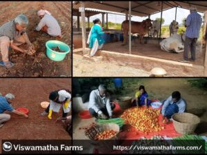
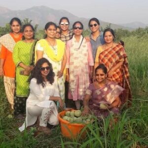
From Boardroom to Barnyard: The Humble Journey of Viswamatha Farms’ Owners
Our personality is a reflection of the work we do. Being involved in agriculture, enhances your modesty, humbleness and attachment to the ground. Viswamatha Farms is one of the most progressive natural farm in South India. The owners of the Farm proactively participate in almost every farm related activities be in tilling, sowing, harvesting, animal care, farm maintenance and so on irrespective of their busy schedule.
We appreciate this kind of humbleness and it is certainly an inspiration for all us involved in agriculture.
Happy Farming!
#farmer #farming #satellite #naturalfarming #vegetation #lowcost #gis #organicfarming #crops #urbanfarming #fieldscouting #remotesensing #greentech #smartfarming #precisionagriculture #agro #farm #agritech #vegetables #agriculture #foodsecurity #technology
Unlock Seamless Access: Farmonaut’s New Multi-Platform Login Feature Empowers Farmers
New Feature (Additional Login Methods): Users can now also sign up / sign in with any custom email ID and password to our android and web platforms. Any account created through either android, iOS or web app can be accessed through any other Farmonaut platform as well and vice-versa.
Happy Farming!
#newfeature #login #soil #soilhealth #soc #organicmatter #farming #organicfarming #crops #urbanfarming #fieldscouting #remotesensing #greentech #smartfarming #precisionagriculture #agro #agrotech #farm #agritech #vegetables #agriculture #foodsecurity #technology #greentech #satellite #vegetation #india #gis
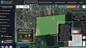
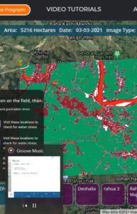
Farmonaut’s Web App Upgrade: Tooltips, Analysis Scales, Multi-Crop Support, and More!
New Features For Web App: With the new update, we are introducing:
1. Tooltips: A short pop-up description of all the major features of the platform, which will help users understand the functioning of buttons etc. much more easily.
2. Analysis Scale: An analysis scale for each of the index (NDVI, EVI, NDRE, VARI, NDWI, SOC). This analysis scale helps user categorize their field area into different health zones much more easily.
3. Ability to add Multiple Crops within a polygon which will help us in providing micro crop level analysis on the platform in the coming days.
4. Dedicated Video Tutorials Button on the top bar which lists all the tutorial videos about various features of the Farmonaut Web App.
We will keep introducing new features in the coming days. Stay tuned!
#webapp #newfeature #organicmatter #farming #organicfarming #crops #urbanfarming #fieldscouting #remotesensing #greentech #smartfarming #precisionagriculture #agro #agrotech #farm #agritech #vegetables #agriculture #foodsecurity #technology #greentech #satellite #vegetation #india #gis #soil #soilhealth #soc
Satellite Insights: Tracking Maize Growth in Argentina with EVI Index
These are a few fields recently added to our platforms for satellite monitoring by one of the users from Argentina. Both of these fields (96 Ha and 27 Ha) have maize and are currently in the early stage of growth. The displayed images are of EVI index. This is a side-by-side comparison of crop growth during a gap of 10 days captured by the satellites from 4th August, 2020 to 14th August, 2020. The data reveals that crop is growing fine at the majority of the locations and at some locations wherein the EVI index is low, a field visit must be conducted at priority and recropping must be performed if the crop has failed to grow in those locations.
By having this data, farmers can maximize their yield.
The app is available on Google Play Store, Apple App Store as well as a Web App on our website.
Happy Farming!
#argentina #soil #soilhealth #soc #organicmatter #farming #organicfarming #crops #urbanfarming #fieldscouting #remotesensing #greentech #smartfarming #precisionagriculture #agro #agrotech #farm #agritech #vegetables #agriculture #foodsecurity #technology #greentech #satellite #vegetation #india #gis
Harvesting Success: How Viswamatha Farms Combines Natural Farming and Precision Agriculture for Bountiful Yields
With this cultivation season about to end, Viswamatha farms have come to harvest black gram, green gram, sorghum, pearl millet and little millet. Aonla and Pomegranate is also due for harvesting this month.
Due to natural farming and PA (precision agriculture) tools they are able to get good harvest and the crop is healthy with no diseases. Viswamatha Farms is one of the most progressive natural farm in South India. The owners of the Farm proactively participate in almost every farm related activities be in tilling, sowing, harvesting, animal care, farm maintenance and so on irrespective of their busy schedule.
Remote sensing in combination with natural farming can do wonders to the agriculture sector.
By using satellite data provided by us, farmers can:
1. Reduce Chemical/Fertilizer consumption by applying them only in the locations where crop health is not good.
2. Reduce Labour costs by directing the labours only in those field areas where crop health is critical.
3. Reduce irrigation water wastage by applying proper irrigation only in those locations where plant water stress is low.
4. Increase overall yield.
5. Maintain good nutrient composition post-harvest by getting the soil testing done on the locations where Farmonaut’s SOC model has identified the level of soil organic carbon to be low.
It can not only reduce and Infact end the use of chemicals on the field but also increase the overall crop yield as well prevent the deterioration of soil nutrient composition which may happen due to the prolonged usage of chemicals on land.
To know more about the work we do, join us on our android, iOS or the web platform. For any information please feel free to contact us on: [email protected] or +91-6366026267.
#farmer #farming #satellite #vegetation #lowcost #gis #organicfarming #crops #urbanfarming #fieldscouting #remotesensing #greentech #smartfarming #precisionagriculture #agro #farm #agritech #gujarat #gandhinagar #agriculture #foodsecurity #technology
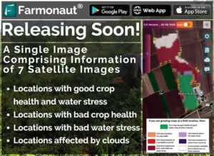
Revolutionary Satellite Fusion: One Image, Four Crucial Farm Insights
We are taking user experience to the next level. Now farmers can assess meaningful data of 7 different satellite images into a single image and take farm level actions at even faster rates. With this newly developed image type, farmers will get information about:
1. Locations with good crop health and water stress
2. Locations with bad crop health
3. Locations with bad water stress
4. Locations affected by clouds
all these information embedded within a single image. Stay tuned! This new update is releasing soon!
Happy Farming!
#newfeature #soil #soilhealth #soc #organicmatter #farming #organicfarming #crops #urbanfarming #fieldscouting #remotesensing #greentech #smartfarming #precisionagriculture #agro #agrotech #farm #agritech #vegetables #agriculture #foodsecurity #technology #greentech #satellite #vegetation #india #gis
From Paddy to Pixels: Tracking Crop Health and Soil Vitality in Bihar’s Farming Hub
With Paddy season about to finish in the coming weeks, the short clip attached below provides an overview of how crop health varied from July (26-July-2020) till August (30-Aug-2020) in one of our extensive farming hubs (Rahua, Bihar). The displayed image is of NDRE (Normalized Difference Red Edge) used to assess crops in the stage of later growth.
The colormap shows majority of the area in good condition and suitable for harvesting in the next few weeks. Once the crop is harvested, we will capture the Soil organic carbon content of the bare land and identify locations where soc content may have gone down. Once these locations are identified, a priority soil testing will be done on those locations.
We will keep everyone posted.
Happy Farming!
#newfeature #soil #soilhealth #soc #organicmatter #farming #organicfarming #crops #urbanfarming #fieldscouting #remotesensing #greentech #smartfarming #precisionagriculture #agro #agrotech #farm #agritech #vegetables #agriculture #foodsecurity #technology #satellite #vegetation #india #gis
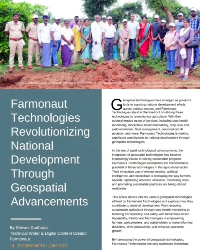
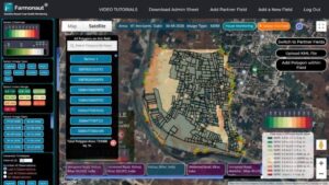
Farmonaut Featured in GIS Resources Magazine: Transforming Spatial Data into Agricultural Intelligence
Check the feature about Farmonaut in the 3rd edition (September 2020) of the print and digital magazine of GIS Resources. The edition titled “Geospatial Technologies: From Data to Information” focuses on the use of various geospatial technologies in the collection of spatial data and then transforming into information.
Magazine Link: https://bit.ly/3kGXeO3
(Link in bio as well)
Thanks to @theimperfectrhyme for bringing together the content for the same.
Happy Farming!
#farming #organicfarming #crops #urbanfarming #fieldscouting #remotesensing #smartfarming #precisionagriculture #agro #agrotech #farm #agritech #agriculture #foodsecurity #technology #greentech #satellite #vegetation #india #gis #soil #soilhealth #soc #organicmatter
Revolutionizing Crop Monitoring: Farmonaut’s Satellite-Powered Precision Farming App
The field displayed is one of our farmers from Rattanpura, Rajasthan having cotton, guar and moong currently under cultivation. The information in the image below can be interpreted as follows:
1. (Green) Locations with good crop health and water stress
2. (Orange) Locations with bad crop health
3. (Purple) Locations with bad water stress
4. (White) Locations affected by clouds
all these information embedded within a single image.
Users who want the high-level analysis (NDVI, NDRE, EVI, VARI, NDWI etc.) can switch to the advanced version of the app just by a tap on the screen.
With Farmonaut’s Satellite Based Crop Health Monitoring System, farmers can monitor their crops for health, manage irrigation water usage, assess variation of crop health with time, discuss with the community their issues and collaborate with each other and can do so much more!!
The app is currently available for download on Google Play Store, Apple App Store as well as a web app!
Happy Farming!! 🙂
#farming #organicfarming #crops #urbanfarming #fieldscouting #remotesensing #android #ios #web #google #apple #iphone #ipad #appstore #playstore #greentech #smartfarming #precisionagriculture #agro #agrotech #farm #agritech #vegetables #agriculture #foodsecurity #technology #satellite #vegetation #india #gis
From Space to Harvest: How Israeli Cotton Farmers Use Satellite NDVI for Perfect Defoliation Timing
The field displayed below is of one of our farmers from Israel and is approximately of area 15 hectares. The satellite data is of 7-Sep-2020. He has been using Farmonaut app since last one year and has been monitoring cotton in the farm. The displayed image is of NDVI (Normalized Difference Vegetation Index).
As is visible from the image, the field has reached its maturity and is ready for defoliation. Identifying the right time for defoliation helps farmers in maximizing their yield. The app is available on Google Play Store, Apple App Store as well as a Web App on our website
Happy Farming!
#soil #soilhealth #soc #organicmatter #farming #organicfarming #crops #urbanfarming #fieldscouting #remotesensing #greentech #smartfarming #precisionagriculture #agro #agrotech #farm #agritech #vegetables #agriculture #foodsecurity #technology #greentech #satellite #vegetation #india #gis
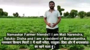
Groundnut Grower’s Success: Narendra Mail’s Journey with Farmonaut in Gujarat
A video testimonial from Narendra Mail from Taluka- Disha, Banaskantha (Gujarat) who has been using Farmonaut since last 1 month. He is cultivating groundnut in his farm.
#remotesensing #gis #farming
Revolutionizing Agriculture: How Viswamatha Farms Combines Natural Farming and Precision Agriculture for Bountiful Harvests
Viswamatha farms (S No. 142/24/34A, 125-1, 126-2, Pedari Katla Village, Konakanametla Mandal, Prakasam District, Andra Pradesh – 523 001) have come to harvest black gram, green gram, sorghum, pearl millet and little millet. Aonla and Pomegranate is also due for harvesting this month.
Due to natural farming and PA (precision agriculture) tools they are able to get good harvest. Remote sensing in combination with natural farming can do wonders to the agriculture sector.
By using satellite data provided by us, farmers can:
1. Reduce Chemical/Fertilizer consumption by applying them only in the locations where crop health is not good.
2. Reduce Labour costs by directing the labours only in those field areas where crop health is critical.
3. Reduce irrigation water wastage by applying proper irrigation only in those locations where plant water stress is low.
4. Increase overall yield.
5. Maintain good nutrient composition post-harvest by getting the soil testing done on the locations where Farmonaut’s SOC model has identified the level of soil organic carbon to be low.
a
It can not only reduce and Infact end the use of chemicals on the field but also increase the overall crop yield as well prevent the deterioration of soil nutrient composition which may happen due to the prolonged usage of chemicals on land.
To know more about the work we do, join us on our android, iOS or the web platform. For any information please feel free to contact us on: [email protected] or +91-6366026267.
#farmer #farming #satellite #vegetation #lowcost #gis #organicfarming #crops #urbanfarming #fieldscouting #remotesensing #greentech #smartfarming #precisionagriculture #agro #farm #agritech #gujarat #gandhinagar #agriculture #foodsecurity #technology
Revolutionizing Irrigation: Farmonaut’s Soil Moisture Sensor Collaboration with N N Brother Farm
Understanding the level of soil moisture on a field can help farmers take irrigation related actions pretty quickly. However, deploying and managing on-field sensors is an expensive work. Farmonaut has come together and collaborated with progressive farmers such as N N Brother Farm and dispatched the portable soil moisture sensors to them. N N Brother Farm (Taluka- Disha, Banaskantha, Gujarat) has already been using Farmonaut’s remote sensing data for a past few months. These sensors will be used to collect soil moisture data at different points of the field at frequent intervals. The collected data will then be correlated with the remote sensing data provided by Farmonaut to develop enhanced remote sensing models for irrigation management.
Happy Farming!
#water #irrigation #soilmoisture #sensors
#farming #organicfarming #crops #urbanfarming #fieldscouting #remotesensing #smartfarming #precisionagriculture #agro #agrotech #farm #agritech #agriculture #foodsecurity #technology #greentech #satellite #vegetation #india #gis #soil #soilhealth #soc #organicmatter
Satellite-Powered Farming: Revolutionizing Crop Health and Water Management
Comment below, how do you monitor and manage crop health and water stress on your farm.
DO YOU KNOW SATELLITES CAN HELP YOU IN THIS?
Let us know your thoughts. Happy Farming☺️!!
The app is available on Google Play Store, Apple App Store as well as a Web App on our website. Happy Farming!
#farming #organicfarming #crops #urbanfarming #fieldscouting #remotesensing #greentech #smartfarming #precisionagriculture #agro #agrotech #farm #agritech #vegetables #agriculture #foodsecurity #technology #satellite #vegetation #india #gis
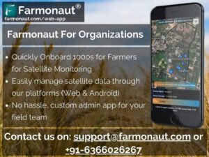
Revolutionizing Farm Management: Farmonaut’s New Admin App Streamlines Large-Scale Agricultural Operations
RELEASING “FARMONAUT FOR ADMINS” APP TO FACILITATE ORGANIZATIONAL USAGE
Managing farmer portfolios of 1000s and lakhs of farmers and generating results (Remote sensing data, weather data, precision agriculture analysis, GEOTIFF images) for them can be time consuming. Not only it limits the number of farmers you can serve but also the amount of money you spend on generating these results through third-party services.
Why not automate this entire process and receive all these results automatically whenever the new data is available.
Farmonaut also provides a no hassle, custom admin app for your field team with which you can onboard 1000s of farmers quickly.
If you are/or know an FPO, Agricultural institution/ company, agricultural consultant etc., drop us an email at [email protected] or contact us on: +91-6366026267 to help you with our offerings.
Happy Farming!
#farming #organicfarming #crops #urbanfarming #fieldscouting #remotesensing #consultant #agriconsultant #greentech #smartfarming #precisionagriculture #farm #agritech #vegetables #agriculture #foodsecurity #technology #satellite #vegetation #india #gis #waterstress #advisor #cropyield
Satellite-Powered Farming: Monitor Crop Health and Water Stress with Farmonaut
Know crop health and water stress information of your farms through satellites. download farmonaut from play store and start monitoring your farrms.
उपग्रहों के माध्यम से खेतों के फसल स्वास्थ्य और पानी के तनाव की जानकारी जानें। प्ले स्टोर से फार्मोनॉट डाउनलोड करें और अपने खेतों की निगरानी शुरू करें।
#remotesensing #greentech #smartfarming #precisionagriculture #agro #agrotech #farm #agritech #vegetables #agriculture #foodsecurity #technology #greentech #satellite #vegetation #india #gis
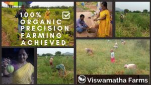
Organic Revolution: Viswamatha Farms Embraces Precision Agriculture for a Sustainable Future
Viswamatha Farms is a name that we all should admire for their dedication towards Natural and Organic Farming. Their recent annual harvest of brown top millets is completely Organic and they have planned to get whole Horticulture products to be 100% Organic by the year 2021.
On top of the Organic farming practices, they also use precision farming data to improve their yield.
#farmer #farming #satellite #vegetation #lowcost #gis #organicfarming #crops #urbanfarming #fieldscouting #remotesensing #greentech #smartfarming #precisionagriculture #agro #farm #agritech #agriculture #foodsecurity #technology #naturalfarming #precisionfarming
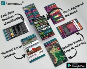
Revolutionizing Agriculture: Farmonaut’s Tech-Driven Approach to Empower Farmers Globally
Farmonaut is built upon a vision to bridge the technological gap between farmers and strives to bring state-of-the-art technologies in the hands of each and every farmer. In its current version, Farmonaut comes bundled with the following features:
• Satellite-Based Crop Monitoring
• Automated Crop Monitoring
• Crop Health Status
• Vegetation Water Level
• Farmers’ Discussion Forum/ Social Network
• Voice-Text Based Plant Issue Identification (50+ Languages Supported)
• Govt. Approved Farming Database (100+ Crops, 300+ Diseases)
• Crop Registration System
• Satellite Imagery Access For Research
and much more..!! Farmonaut believes in adapting and improving with time. Your
suggestions and feedback are highly valuable to us.
#farming #organicfarming #crops #urbanfarming #fieldscouting #remotesensing #agriconsultant #greentech #smartfarming #precisionagriculture #farm #agritech #vegetables #agriculture #foodsecurity #technology #satellite #vegetation #india #gis #waterstress #advisor #cropyield #socialnetwork
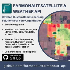
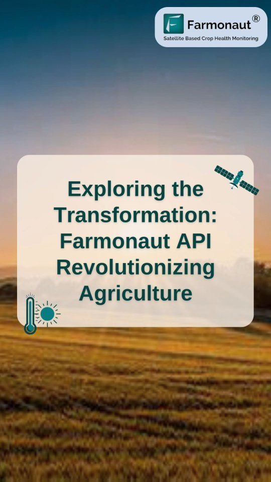
Unleash Agricultural Innovation: Farmonaut’s Satellite & Weather API Empowers Custom Remote Sensing Solutions
FARMONAUT SATELLITE & WEATHER API
Now you can develop your own custom agricultural remote sensing solutions for your organization based upon Farmonaut Technologies. Simply make a few API requests and our systems will automatically generate all the satellite data (NDVI, NDWI, EVI, VARI, SOC, TCI, ETCI and HYBRID) as well as the weather data for all the fields submitted by your organization.
Refer to the Github documentation of the API and start developing your solutions!
Happy Farming!
#api #farming #farm #harvest #precisionagriculture #organicfarming #greentech #technology #tech #foodsecurity #agrotech #agriculture #satellite #crophealth #farmonaut #fruit #vegetables #crops #agro #agritech #remotesensing #gis #earth #remotesensing
From Satellites to Organic Custard Apples: Viswamatha Farms’ Journey to Precision Agriculture
Viswamatha Farms harvested custard apples from their farm recently. They harvest 100 kg of custard apple at a time. Their harvest is completely organic and they have planned to get whole Horticulture products to be 100% organic by the year 2021.
On top of the organic farming practices, they also use precision farming data to improve their yield.
#farmer #farming #satellite #vegetation #lowcost #gis #organicfarming #crops #urbanfarming #fieldscouting #remotesensing #greentech #smartfarming #precisionagriculture #agro #farm #agritech #agriculture #foodsecurity #technology #naturalfarming #precisionfarming
Satellite Insights: Tracking Paddy Harvest and Soil Health in Bihar’s Farming Hub
(AVAILABLE ON ANDROID, IOS AND AS A WEB APP)
FARMONAUT SATELLITE BASED CROP HEALTH MONITORING
Within Last 2 weeks, around 50% of the Paddy has been harvested in one of our extensive farming hubs at Saharsa, Bihar. Though, water logging and fungus infestation occurred during this period, but the overall crop in the region was in good condition while the harvest started. The image attached below provides an overview of how crop health varied from Oct (24-Oct-2020) till November (3-Nov-2020) The displayed image is of EVI (Enhanced vegetation Index).
The colormap shows majority of the area in good condition and suitable for harvesting in the next few weeks. Once the crop is harvested completely, we will capture the Soil organic carbon content of the bare land and identify locations where soc content may have gone down. Once these locations are identified, a priority soil testing will be done on those locations.
We will keep everyone posted.
Happy Farming!
#newfeature #soil #soilhealth #soc #organicmatter #farming #organicfarming #crops #urbanfarming #fieldscouting #remotesensing #greentech #smartfarming #precisionagriculture #agro #agrotech #farm #agritech #vegetables #agriculture #foodsecurity #technology #satellite #vegetation #india #gis
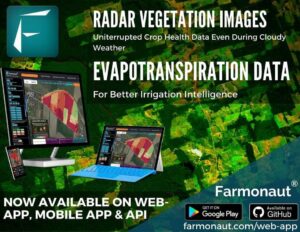
Revolutionizing Crop Monitoring: Farmonaut Introduces Radar and Evapotranspiration Satellite Data
Today, we are releasing two new types of satellite data to further enhance our satellite based crop health monitoring offerings. From now onwards, all the users of the Farmonaut Platform (Web, Smartphone users as well as API users) will receive Radar Vegetation Images as well as Evapotranspiration Data too on top of several other satellite images already provided by us.
WHY DO WE NEED SYNTHETIC APERTURE RADAR IMAGES?
Cloudy weather notoriously interrupts capturing crop health metrics several times, especially in rainy season. Synthetic Aperture Radar penetrates clouds and guarantees reliable data supply throughout the year. Other information like phenological stage of cropland, growth dynamic or crop-type differentiation can also be derived from SAR data.
WHY DO WE NEED EVAPOTRANSPIRATION IMAGES?
Evapotranspiration (ET) is an important soil water balance component and plays major role in determining the potential yields in the agricultural sector. It is a key variable in many disciplines including irrigation management, crop growth, hydrologic cycle, plant physiology, soil-plant-water-atmosphere relationships, microclimate and surface interactions, and drainage studies.
In our quest to provide state-of-the-art technologies to the farmers we will keep pushing our limits. Farmonaut believes in adapting and improving with time. Your suggestions and feedback are highly valuable to us.
Happy Farming!
#farming #farm #harvest #precisionagriculture #organicfarming #greentech #technology #tech #foodsecurity #agrotech #agriculture #satellite #crophealth #farmonaut #fruit #vegetables #crops #agro #agritech #remotesensing #gis #earth #remotesensing #radar #evapotranspiration #sar
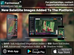
Unveiling Advanced Crop Health Indices: SAVI, AVI, BSI, and SI Now Available on Farmonaut
Today, we are releasing Soil Adjusted Vegetation Index (SAVI), Advanced Vegetation Index (AVI), Bare Soil Index (BSI), and Shadow Index (SI) through our web-app and for our API.
These indices play very important role in improving the capabilities of the crop health assessments when soil exposure can alter the actual observation of the crop health. These indices will help to mitigate these issues.
Happy farming!
#farming #organicfarming #crops #urbanfarming #fieldscouting #remotesensing #greentech #smartfarming #precisionagriculture #agro #agrotech #farm #agritech #vegetables #agriculture #foodsecurity #technology #greentech #satellite #vegetation #india #gis

Mexico’s Precision Agriculture Revolution: Inspired by Farmonaut’s Success
It is great to see that the work done by Farmonaut is encouraging other countries to take such initiatives in their own region as well. Read this article to see what Mexico is planning to do and how it takes inspiration from startups like Farmonaut. Link in Bio.
https://mexicobusiness.news/infrastructure/news/mexico-build-precision-agriculture-infrastructure
#mexico #farming #organicfarming #crops #urbanfarming #fieldscouting #remotesensing #greentech #smartfarming #precisionagriculture #agro #agrotech #farm #agritech #agriculture #foodsecurity #technology #satellite #vegetation #india #gis #soil #soilhealth
Satellite Sentinels: How Farmonaut’s Tech is Revolutionizing Disease Detection for Indian Farmers
Indian farmers have a wealth of knowledge when it comes to agriculture. But predicting the onset of any disease surely doesn’t fall in their realm. So where the farmer falls short, technology can come in handy.
Check this latest feature about Farmonaut by The New Indian Express. (Link in Bio)
#farming #organicfarming #crops #urbanfarming #fieldscouting #remotesensing #greentech #smartfarming #precisionagriculture #agro #agrotech #farm #agritech #vegetables #agriculture #foodsecurity #technology #satellite #vegetation #india #gis
Revolutionizing Agriculture: How Farmonaut’s Satellite Technology Empowers Farmers
Farmonaut matches the user location with satellite coordinates and fetches the latest imagery, and runs a series of image processing algorithms to deliver the best quality results to the farmers. Upon identifying the regions of unhealthy growth in the fields, farmers can simply pay a visit to that part of the field and identify if the problem has already started. If it has not, the farmer can take preventive remedies by applying more fertilizers, plant growth regulators etc. If the problem has already started, they can simply explain their problem to Farmonaut’s crop issue identification system and get real-time govt. approved remedies. Apart from this, farmers also receive vegetation water stress and soil organic carbon data as well! Farmonaut strives to bring state of the art technologies in the grasp of every farmer and will continue adding more features in the coming days. ☺️ Happy Farming!! 🌱🌾👩🌾 #farming #farm #harvest #agrotech #agriculture #satellite #crophealth #farmonaut #fruit #vegetables #crops #agro #agritech #precisionagriculture #organicfarming #greentech #technology #tech #foodsecurity #farmersofinstagram #farmerlife #urbanfarmer #urbanfarming #nasa #esa #spacex #remotesensing #gis #earth #earthfromabove
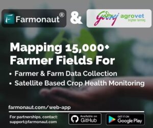
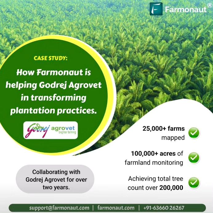
Godrej Agrovet Partners with Farmonaut to Map and Monitor 15,000+ Farmer Fields Using Satellite Technology
It gives us great pleasure to announce that Godrej Agrovet is mapping 15,000+ farmer fields through Farmonaut’s ecosystem of platforms to capture farmer and farm level data. On top of this data, the mapped fields will also be monitored through Farmonaut’s Satellite Based Crop Health Monitoring System in the coming days for crop health, water stress, evapotranspiration, soil organic carbon, weather forecasting etc.
Happy Farming!
#farming #farm #harvest #agrotech #agriculture #godrej #godrejagrovet #satellite #crophealth #farmonaut #fruit #vegetables #crops #agro #agritech #precisionagriculture #organicfarming #greentech #technology #tech #foodsecurity #farmersofinstagram #farmerlife #urbanfarmer #urbanfarming #remotesensing #gis #earth #earthfromabove
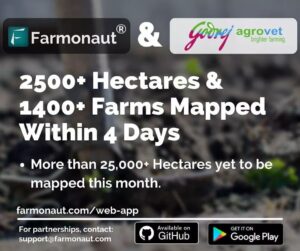
Godrej Agrovet’s Massive Field Mapping Initiative: 15,000+ Farms to Benefit from Farmonaut’s Satellite Monitoring
More than 2500+ hectares of area and 1400+ farmer fields have been mapped by Godrej Agrovet in the last 4 days through their ground team. Godrej Agrovet is mapping 15,000+ farmer fields and 30,000+ hectares of farmland through Farmonaut®’s ecosystem of platforms to capture farmer and farm-level data. On top of this data, the mapped fields will be monitored through Farmonaut’s Satellite-Based Crop Health Monitoring System in the coming days for crop health, water stress, evapotranspiration, soil organic carbon, weather forecasting, etc.
Happy Farming!
#farming #farm #harvest #agrotech #agriculture #godrej #godrejagrovet #satellite #crophealth #farmonaut #fruit #vegetables #crops #agro #agritech #precisionagriculture #organicfarming #greentech #technology #tech #foodsecurity #farmerlife #urbanfarmer #urbanfarming #nasa #remotesensing #gis #earth #earthfromabove
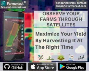
Satellite-Powered Precision: Timing Your Harvest for Maximum Yield with Farmonaut
To maximize your yield, it is essential that your crop is harvested at the right time. Through Satellite Data provided by Farmonaut you can precisely identify when your crop is ready for harvest and get maximum yield from your crop.
Farmonaut is available on android, iOS as well as web-app. Download now and get started!
Happy Farming!
#farming #organicfarming #urbanfarming #fieldscouting #remotesensing #greentech #smartfarming #precisionagriculture #farm #agritech #agriculture #foodsecurity #technology #satellite #india #gis #wheat
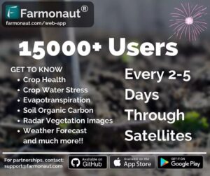
15,000 Strong: Farmonaut’s Digital Farming Revolution Grows!
We are happy to announce that more than 15000 users are now on board the Farmonaut platform!! (android, iOS, and web app) Thanks a lot for your support! We will keep pushing hard to bring more innovation in the farming sector. Stay tuned!!
Happy Farming!! 🙂
#farming #organicfarming #crops #urbanfarming #fieldscouting #remotesensing #android #ios #apple #iphone #ipad #appstore #playstore #greentech #smartfarming #precisionagriculture #agro #agrotech #farm #agritech #vegetables #agriculture #foodsecurity #technology #satellite #vegetation #india #gis
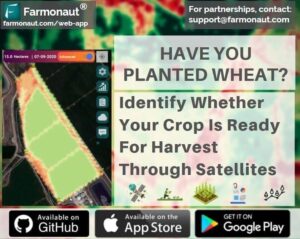
Satellite-Powered Precision: Maximizing Wheat Harvest with Farmonaut’s Cutting-Edge Technology
With Wheat being in the final weeks of maturity, it is essential that it is harvested at the right time. Through Satellite Data provided by Farmonaut you can precisely identify when your crop is ready for harvest and get maximum yield from your crop. Farmonaut is available on android, iOS as well as web-app. Download now and get started!
Happy Farming!
#farming #organicfarming #urbanfarming #fieldscouting #remotesensing #greentech #smartfarming #precisionagriculture #farm #agritech #agriculture #foodsecurity #technology #satellite #india #gis #wheat

Revolutionizing Agribusiness: Farmonaut’s Seamless Satellite Integration for Crop Health Monitoring
We are glad to announce a new addition to our list of features that is going to solve all the woes of business houses seeking the need for satellite data in the agriculture industry. Farmonaut® has made it easier for businesses to integrate the Satellite-Based crop health monitoring system provided by them with-in their websites by adding just a few lines of integration code.
With this, the businesses will be able to host Farmonaut’s systems on their websites and provide all of its cutting-edge services and platform features to their users. By hosting Farmonaut’s system on their websites, businesses will be able to increase their revenue influx as the revenue generated through this integration will be shared with the hosting website as well. Furthermore, the users subscribing to Farmonaut’s services through the website will also be provided an exclusive discount.
Happy Farming!
ISRO – Indian Space Research Organisation U.S. Department of Agriculture NASA – National Aeronautics and Space Administration NASSCOM CNBC Indian Meteorological Department
#farming #organicfarming #urbanfarming #fieldscouting #remotesensing #greentech #smartfarming #precisionagriculture #farm #agritech #agriculture #foodsecurity #technology #satellite #india #gis
Unveiling Crop Health: The Power of Hybrid Satellite Imagery in Smart Farming
In this video, we will show you the hybrid image generated by our systems. This hybrid image combines information of several satellite images and displays it as a single image. This helps any user to have an upper level overview about crop health and water stress status of the field from this single image.
#farming #organicfarming #urbanfarming #fieldscouting #remotesensing #greentech #smartfarming #precisionagriculture #farm #agritech #agriculture #foodsecurity #technology #satellite #india #gis #wheat

Slash Fertilizer Costs by 30%: How Farmonaut’s Remote Sensing Tech Saves Indian Farmers Lakhs
In 2016, fertilizer consumption for India was 165.8 kilograms per hectare. Fertilizer consumption of India increased from 100.3 kilograms per hectare in 2002 to 165.8 kilograms per hectare in 2016 growing at an average annual rate of 3.81 %.⠀
The chemical price can vary from 250 rupees to 2000 rupees per kg depending upon the specific chemical being used. So on an average an Indian farmer spends between 41500 to 332000 rupees per year on each hectare of arable land.⠀
⠀
Farmonaut identifies those areas of land where the crop growth is not normal. Farmer can apply fertilizers, chemicals, insecticides, pesticides, plant growth regulators etc. only in⠀
those areas where the crop growth is not normal. By using⠀
remote sensing results provided by Farmonaut, a farmer can save at least 30% on chemical consumption per year.⠀
So for every one hectare of land, farmer can save at least between 12000 (~ $160) and 95000 (~ $1300) rupees per year.⠀
⠀
The app is available on Google Play Store, Apple App Store as well as a Web App on our website. Happy Farming!⠀
⠀
#farming #organicfarming #crops #urbanfarming #fieldscouting #remotesensing #greentech #smartfarming #precisionagriculture #agro #agrotech #farm #agritech #vegetables #agriculture #foodsecurity #technology #satellite #vegetation #india #gis

From Satellite to Spice: Organic Turmeric and Red Chili Harvest at Viswamatha Farms
One of our long-time users Viswamatha Farms have harvested fully organic Turmeric and Red chili. Please contact us/ comment below if you want to buy the same. The organic certification will be provided as well.
Happy Farming!
#farmer #farming #satellite #vegetation #lowcost #gis #organicfarming #crops #urbanfarming #fieldscouting #remotesensing #greentech #smartfarming #precisionagriculture #agro #farm #agritech #agriculture #foodsecurity #technology #naturalfarming #precisionfarming

Empowering Student Research: Farmonaut Offers Free Access to Advanced Agricultural Satellite Data
Farmonaut is offering full access to the students who want to conduct their research studies. Login To Our Web-App Using Your University Email ID and send us the proof of being an active student (Student ID Card) on [email protected].
Continuous Satellite Data & Weather Data
NDVI, EVI, SAVI, NDRE, NDWI, EVAPOTRANSPIRATION, SOC, Radar and so many more datasets.
Have an idea but not sure how to take it further? Send us an email and we will help you with the proposal.
#farming #organicfarming #crops #urbanfarming #fieldscouting #remotesensing #agriconsultant #greentech #smartfarming #precisionagriculture #farm #agritech #vegetables #agriculture #foodsecurity #technology #satellite #vegetation #india #gis #waterstress #advisor #cropyield #farming #organicfarming #crops #urbanfarming #fieldscouting #remotesensing #agriconsultant #greentech #smartfarming #precisionagriculture #farm #agritech #vegetables #agriculture #foodsecurity #technology #satellite #vegetation #india #gis #waterstress #advisor #cropyield #socialnetworking#socialnetwork

Satellite Surveillance: Your Key to Safe and Smart Farming During COVID-19
Reduce your field visits by monitoring your fields for crop health and water stress through satellite data. Farmonaut provides satellite data to the farmers every 4-5 days. By monitoring your fields through satellites you can reduce your field visits and can make them only when they are necessary. In these challenging days it is essential for everyone to stay home as much as they could and stay safe from the coronavirus pandemic. Start monitoring your fields right now through Farmonaut android app, iOS app or the web app.
Happy Farming!
#coronavirus #covid19 #pandemic #quarantine #juntacurfew #stayhome #farmer #farming #satellite #naturalfarming #vegetation #lowcost #gis #organicfarming #crops #urbanfarming #fieldscouting #remotesensing #greentech #smartfarming #precisionagriculture #agro #farm
From Field to Spice: Organic Turmeric Processing at Viswamatha Farm
Recent pictures on turmeric processing at Viswamatha Farm, one of our long-time users. Please contact us/ comment below if you want to buy the same. The organic certification will be provided as well.
Happy Farming!
#farmer #farming #satellite #vegetation #lowcost #gis #organicfarming #crops #urbanfarming #fieldscouting #remotesensing #greentech #smartfarming #precisionagriculture #agro #farm #agritech #agriculture #foodsecurity #technology #naturalfarming #precisionfarming
Revolutionizing Mango Farming: How Viswamatha Farms Combines Natural Methods with Precision Agriculture
Mango Harvest at Viswamatha Farms.
Due to natural farming and PA (precision agriculture) tools they are able to get good harvest.
Remote sensing in combination with natural farming can do wonders to the agriculture sector.
By using satellite data provided by us, farmers can:
1. Reduce Chemical/Fertilizer consumption by applying them only in the locations where crop health is not good.
2. Reduce Labour costs by directing the labours only in those field areas where crop health is critical.
3. Reduce irrigation water wastage by applying proper irrigation only in those locations where plant water stress is low.
4. Increase overall yield.
5. Maintain good nutrient composition post-harvest by getting the soil testing done on the locations where Farmonaut’s SOC model has identified the level of soil organic carbon to be low.
a
It can not only reduce and Infact end the use of chemicals on the field but also increase the overall crop yield as well prevent the deterioration of soil nutrient composition which may happen due to the prolonged usage of chemicals on land.
To know more about the work we do, join us on our android, iOS or the web platform. For any information please feel free to contact us on: [email protected] or +91-6366026267.
#farmer #farming #satellite #vegetation #lowcost #gis #organicfarming #crops #urbanfarming #fieldscouting #remotesensing #greentech #smartfarming #precisionagriculture #agro #farm #agritech #agriculture #foodsecurity #technology #naturalfarming #precisionfarming
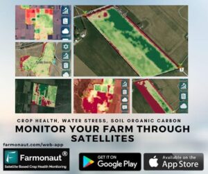
Revolutionizing Agriculture: Farmonaut’s High-Tech Solutions for Modern Farmers
Farmonaut is built upon a vision to bridge the technological gap between farmers and strives to bring state-of-the-art technologies in the hands of each and every farmer. In its current version, Farmonaut comes bundled with the following features: • Satellite-Based Crop Monitoring: • Automated Crop Monitoring• Crop Health Status• Vegetation Water Level• Farmers’ Discussion Forum/ Social Network• Voice-Text Based Plant Issue Identification (50+ Languages Supported)• Govt. Approved Farming Database (100+ Crops, 300+ Diseases)• Crop Registration System• Satellite Imagery Access For Research, and much more..!! In our quest to provide state-of-the-art technologies to the farmers we will keep pushing our limits. Farmonaut believes in adapting and improving with time. Your suggestions and feedback are highly valuable to Farmonaut as it will help to build future versions of the app. Happy Farming! :) #farming #farm #harvest #precisionagriculture #organicfarming #greentech #technology #tech #foodsecurity #agrotech #agriculture #satellite #crophealth #farmonaut #fruit #vegetables #crops #agro #agritech #remotesensing #gis #earth #remotesensing
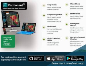
Revolutionizing Crop Monitoring: Farmonaut Unveils NDMI and DEM Satellite Data
Today, we are releasing two new types of satellite data to further enhance our satellite based crop health monitoring offerings. From now onwards, all the users of the Farmonaut Platform (Web, Smartphone users as well as API users) will receive Moisture Images (NDMI) as well as Digital Elevation Model (DEM) Data too on top of several other satellite images already provided by us.
The NDMI is a normalized difference moisture index, that uses NIR and SWIR bands to display moisture. The SWIR band reflects changes in both the vegetation water content and the spongy mesophyll structure in vegetation canopies, while the NIR reflectance is affected by leaf internal structure and leaf dry matter content but not by water content. The combination of the NIR with the SWIR removes variations induced by leaf internal structure and leaf dry matter content, improving the accuracy in retrieving the vegetation water content.
A Digital Elevation Model (DEM) is a representation of the bare ground (bare earth) topographic surface of the Earth excluding trees, buildings, and any other surface objects.
In our quest to provide state-of-the-art technologies to the farmers we will keep pushing our limits. Farmonaut believes in adapting and improving with time. Your suggestions and feedback are highly valuable to us.
Happy Farming!
#farming #farm #harvest #precisionagriculture #organicfarming #greentech #technology #tech #foodsecurity #agrotech #agriculture #satellite #crophealth #farmonaut #fruit #vegetables #crops #agro #agritech #remotesensing #gis #earth #remotesensing #radar #evapotranspiration #sar
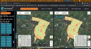
Revolutionizing Agriculture: Farmonaut’s Satellite Tech Estimates Paddy and Wheat Yields Across India
Farmonaut’s Highly Advanced Satellite Based Crop Monitoring Platforms are capable of disseminating data not only to the most basic small scale farmer, but also to facilitate advanced custom research works as well. That’s the level of technology penetration we are working on and delivering as well to our end user. In this latest study, using our platforms, we estimated yields for Paddy (in Kharif Season 2020-2021) and Wheat (in Rabi 2020-2021). Read it in detail at this link:
https://buff.ly/35mTQ5m
#farming #organicfarming #urbanfarming #fieldscouting #remotesensing #greentech #smartfarming #precisionagriculture #farm #agritech #agriculture #foodsecurity #technology #satellite #india #gis #wheat #rabi #kharif
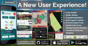
Revolutionizing Farm Management: Farmonaut’s New UI Brings Satellite Data to Your Fingertips
At Farmonaut, we take user feedback very seriously and try our best to integrate user feedback into our platform as early as possible. Today, we are releasing a completely redesigned user-interface of our satellite monitoring system. Through this newly designed interface, farmers can now manage their farms through satellite data, access farmers’ social network and browse through their field data with much more ease. Update your app now to access this newly designed interface. The new UI is currently available for android users.
More exciting news coming soon! Stay tuned!
Happy Farming! 🙂
#evi #ndvi #ndwi #vegetation #soil #aerosol
#organicfarming #crops #urbanfarming #fieldscouting #remotesensing #consultant #agriconsultant #greentech #smartfarming #precisionagriculture #farm #agritech #vegetables #agriculture #foodsecurity #technology #satellite #india #gis #waterstress #advisor #cropyield
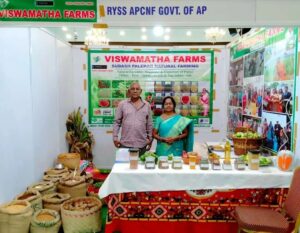
Satellite-Powered Success: Viswamatha Farms’ 2-Year Journey with Farmonaut’s Crop Monitoring Technology
A company’s strongest validation comes from its long term users.
We are glad to be serving Viswamatha Farms with our satellite based crop health monitoring technology for more than 2 years now (user since September 2019).
http://viswamathafarms.com/
The above images are from the event organized by RYSS APCNF (Rythu Sadhikara Samstha – Andhra Pradesh Community Managed Natural Farming) wherein Viswamatha Farms has been invited to showcase their natural farming products.
Viswamatha Farms believes in the power of nature and the positive change it can have on our land and peoples lives. It is passionate about real natural food that tastes great, is of highest quality, is full of nutrients and is good for our health and environment. All the products are produced by natural farming techniques of Shri. Subhash Palekar ji without using any chemicals.
Remote sensing in combination with natural farming can do wonders to the agriculture sector. It can not only reduce and Infact end the use of chemicals on the field but also increase the overall crop yield as well prevent the deterioration of soil nutrient composition which may happen due to the prolonged usage of chemicals on land.
To know more about the work we do, join us on our android, iOS or the web platform. For any information please feel free to contact us on: [email protected] or +91-6366026267.
#farmer #farming #satellite #vegetation #lowcost #gis #organicfarming #crops #urbanfarming #fieldscouting #remotesensing #greentech #smartfarming #precisionagriculture #agro #farm #agritech #agriculture #foodsecurity #technology
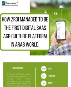
ZR3i.COM: Pioneering Egypt’s AgTech Revolution with Farmonaut Partnership
We are very happy to see our partner ZR3i.COM زرعي دوت كوم getting the well deserved recognition in the Egyptian market! Kudos to Walid Nasr and his team!
Author: Shivani Dudhatra @ladyboss_26
#farming #organicfarming #crops #urbanfarming #fieldscouting #remotesensing #greentech #smartfarming #precisionagriculture #farm #agritech #vegetables #agriculture #foodsecurity #technology #greentech #satellite #vegetation #india #gis

IIM Indore Students Join Farmonaut: Cultivating Innovation in Precision Agriculture
We are glad to welcome Students from @iim_indore IIM Indore for getting experience of various live projects going on within the company. Cheers to the @prodlab_iimi Prodlab | Product Management Club, IIM Indore for arranging such a talented pool of students.
#farming #organicfarming #crops #urbanfarming #fieldscouting #remotesensing #greentech #smartfarming #precisionagriculture #agro #agrotech #farm #agritech #vegetables #agriculture #foodsecurity #technology #greentech #satellite #vegetation #india #gis
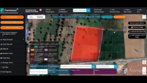
Satellite Sentinels: How Space-Age Tech is Revolutionizing Crop Management
Here’s a comprehensive 5000+ word blog post incorporating the requested
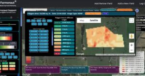
Precision at Your Fingertips: Unveiling Crop Performance with Multi-Polygon Field Selection
Selecting a polygon within a field is o9nly a matter of few mouse clicks. Just select smaller fields within the already selected field and get minute crop performance details of any smaller patch of land within the selected field on the go. This will be very useful for farmers who cultivate only a portion of their land at a particular point of time. Just select as many polygons as you want within your field and retrieve data on the go!
Happy Farming! #farming #organicfarming #crops #urbanfarming #fieldscouting #remotesensing #greentech #smartfarming #precisionagriculture #farm #agritech #agriculture #foodsecurity #technology #satellite #vegetation #india #gis #soil #soilhealth #soc #webapp #newfeature #organicmatter
Revolutionizing Cotton Farming: IoT’s Impact on Yield and Sustainability
A new report is released providing an in-depth analysis of IOT in Cotton Farming and factors affecting the growth of cotton. The study shows how technologies could be the vital part of the farming culture.
This report is curated by @ladyboss_26 Shivani Dudhatra (MBA, Navsari Agricultural University, Agribusiness Management Research Intern, Farmonaut)
Read it on this link: https://cutt.ly/oQpE9c1
Happy farming!
#iot #soil #soilhealth #soc #organicmatter #farming #organicfarming #crops #urbanfarming #fieldscouting #remotesensing #greentech #smartfarming #precisionagriculture #agro #agrotech #farm #agritech #vegetables #agriculture #foodsecurity #technology #greentech #satellite #vegetation #india #gis

Farmonaut’s Tech Revolution: Mapping 20,000+ Farms for Godrej Agrovet
We believe in delivering Technology at scale. Our seamless and easy-to-use farm mapping and traceability technology has helped Godrej Agrovet Limited in mapping and geo-tagging more than 20,000 farms in a short span of time, and the buck doesn’t stop here. Mapping of thousands of farms is still in progress.
Yes we are accomplishing these milestones being completely bootstrapped and we take pride in the same.
Several new things are in the pipeline. Stay tuned for more!
Happy Farming!
#farming #farm #harvest #agrotech #agriculture #godrej #godrejagrovet #satellite #crophealth #farmonaut #fruit #vegetables #crops #agro #agritech #precisionagriculture #organicfarming #greentech #technology #tech #foodsecurity #farmerlife #urbanfarmer #urbanfarming #nasa #remotesensing #gis #earth #earthfromabove
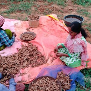
From Satellite to Spice: Viswamatha Farms’ Organic Turmeric Triumph
One of our long-time users Viswamatha Farms have harvested fully organic Turmeric. Please contact us/ comment below if you want to buy the same. The organic certification will be provided as well.
Happy Farming!
#farmer #farming #satellite #vegetation #lowcost #gis #organicfarming #crops #urbanfarming #fieldscouting #remotesensing #greentech #smartfarming #precisionagriculture #agro #farm #agritech #agriculture #foodsecurity #technology #naturalfarming #precisionfarming
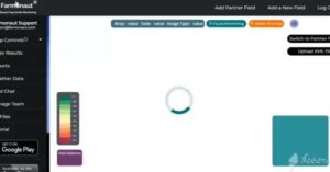
Unveiling Field Evolution: Farmonaut’s Side-by-Side Image Comparison Tool
COMPARE FIELD IMAGES SIDE-BY-SIDE
While Monitoring the farms, you may want to observe changes in the field by comparing two images simultaneously. This is very easy to do with Farmonaut’s compare images option. You can select any two dates of satellite visits and compare results side by side on the map of the Farmonaut web app itself.
Happy Farming!
#webapp #newfeature #organicmatter #farming #organicfarming #crops #urbanfarming #fieldscouting #remotesensing #greentech #smartfarming #precisionagriculture #agro #agrotech #farm #agritech #vegetables #agriculture #foodsecurity #technology #greentech #satellite #vegetation #india #gis #soil #soilhealth #soc
Unlocking Sustainable Farming: The Power of Organic Footprint Data Revealed
A new report is released about Importance of Organic Footprint Data in farming. This report is curated by Shivani Dudhatra (MBA, Navsari Agricultural University, Agribusiness Management Research Intern, Farmonaut)
Read it on this link: https://cutt.ly/SQBK9W2
Happy farming!
#iot #soil #soilhealth #soc #organicmatter #farming #organicfarming #crops #urbanfarming #fieldscouting #remotesensing #greentech #smartfarming #precisionagriculture #agro #agrotech #farm #agritech #vegetables #agriculture #foodsecurity #technology #greentech #satellite #vegetation #india #gis
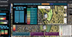
Micro-Precision: Unveiling Crop Performance Secrets Within Your Fields
TAKING PRECISION IN PRECISION AGRICULTURE TO THE NEXT LEVEL!
Now you can select smaller fields within your already selected field and get minute crop performance details of any smaller patch of land within your selected field. Just select as many polygons as you want within your field and retrieve data on the go!
Happy Farming!
#webapp #newfeature #organicmatter #farming #organicfarming #crops #urbanfarming #fieldscouting #remotesensing #greentech #smartfarming #precisionagriculture #agro #agrotech #farm #agritech #agriculture #foodsecurity #technology #satellite #vegetation #india #gis #soil #soilhealth #soc

Revolutionizing Agriculture: Unlocking Farm Traceability with IoT and Smart Tech
A new report is released about Business Opportunities And Technology Use In Farm Traceability. It will guide you through what traceability is all about and how it can transform agriculture.
This report is curated by Shivani Dudhatra (MBA, Navsari Agricultural University, Agribusiness Management Research Intern, Farmonaut)
Read it on this link: https://cutt.ly/ZQmHUEz
Happy farming!
#iot #soil #soilhealth #soc #organicmatter #farming #organicfarming #crops #urbanfarming #fieldscouting #remotesensing #greentech #smartfarming #precisionagriculture #agro #agrotech #farm #agritech #vegetables #agriculture #foodsecurity #technology #greentech #satellite #vegetation #india #gis

Farmonaut Soars: Recognized as Top AgTech Startup Shaping the Future of Farming
We are glad to share that we are listed as one of the Best AgTech Startups – The Future of Farming by The Startup Pill.
We thank The Startup Pill for appreciating our hard work done in the field of agriculture.
We will continue to innovate and bring state-of-the-art technologies in the hands of each and every farmer and farming enthusiast. There are many more news in the pipeline. Stay Tuned!
Happy Farming!
#company #farming #organicfarming #crops #urbanfarming #fieldscouting #remotesensing #greentech #smartfarming #precisionagriculture #agro #agrotech #farm #agritech #vegetables #agriculture #foodsecurity #technology #satellite #vegetation #india #gis
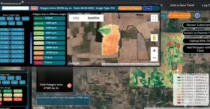
Revolutionize Your Farming: Unlock Field Performance Insights with Farmonaut’s Satellite-Based Crop Health Monitoring
Once the cultivation is over, it is often necessary to identify how your field performed during the previous crop cycle. Farmonaut lets you do this analysis for various field factors and enables you to make method corrections for the next crop cycle. Farmonaut’s Satellite Based crop Health Monitoring platform is available on android, iOS as well as the website.
Happy Farming! #farming #organicfarming #crops #urbanfarming #fieldscouting #remotesensing #greentech #smartfarming #precisionagriculture #farm #agritech #agriculture #foodsecurity #technology #satellite #vegetation #india #gis #soil #soilhealth #soc #webapp #newfeature #organicmatter

Unlock Free Satellite Data: Boost Your Farmonaut Trust Rating to 50+
GET FREE SATELLITE DATA!
Increase your Trust Rating On The Farmonaut Discussion Forum To 50+, and get satellite data for any field for free!
How To Increase Trust Rating?
1. Share Content On Farmonaut Discussion Forum
2. Provide Solutions To The Farmer Problems On The Discussion Forum
MORE THE LIKES ON YOUR POSTED CONTENT AND PROVIDED SOLUTIONS, THE MORE IS YOUR TRUST RATING!
Download The App From Google Play Store Now!
Crop Health, Water Stress, Evapotranspiration, Soil Organic Carbon, Radar Data, Weather Forecast, Farmers’ Social Network, Govt. Approved Database and so much more!
For partnerships/ large scale/ custom requirements contact us at: [email protected]
#farming #organicfarming #crops #urbanfarming #fieldscouting #remotesensing #agriconsultant #greentech #smartfarming #precisionagriculture #farm #agritech #vegetables #agriculture #foodsecurity #technology #satellite #vegetation #india #gis #waterstress #advisor #cropyield #socialnetwork
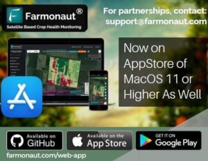
Farmonaut Takes Root on MacOS: Precision Farming Now at Your Fingertips!
We are excited to announce that Farmonaut is now available on App Store of MacOS 11 or higher as well!!
Get the app now from Apple App Store!
#farming #organicfarming #crops #urbanfarming #fieldscouting #remotesensing #ios #apple #iphone #ipad #appstore #greentech #smartfarming #precisionagriculture #agro #agrotech #farm #agritech #vegetables #agriculture #foodsecurity #technology #satellite #vegetation #india #gis
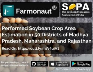
Revolutionizing Soybean Cultivation: Farmonaut’s Precision Mapping Across 50 Districts
We have successfully performed area estimation of Soybean at 50 different districts in Madhya Pradesh, Maharashtra, and Rajasthan for SOPA (The Soybean Processors Association of India) (https://www.sopa.org/)
Soybean, a high value oilseed crop, is predominantly grown in the rainfed agro-ecosystem of central and peninsular India. Accurate and up-to-date assessment of the spatial distribution of soybean cultivated area is a key information required to understand the crop under sown.
We used Optical remote sensing methods for deriving crop information such as crop type map, biophysical parameters, crop growth stages, yield etc.
For more details, check the following link: https://farmonaut.com/crop-area-estimation/soybean-crop-area-estimation-in-50-districts-of-madhya-pradesh-maharashtra-rajasthan/
#soybean #sopa #farming #farm #harvest #precisionagriculture #organicfarming #greentech #technology #tech #foodsecurity #agrotech #agriculture #satellite #crophealth #farmonaut #fruit #vegetables #crops #agro #agritech #remotesensing #gis #earth #remotesensing
Revolutionizing Agriculture: How Farmonaut’s Satellite Technology is Empowering Farmers and Boosting Yields
LINK IN BIO
Thanks to @globallaunchbase for covering our work and how we are helping out the individual farmers and businesses increasing their yield, reduce crop loss, reduction in farm input given to the farms and so much more through satellite data.
For a small farmer (field area less than 5 acre), the cost of 1 month of satellite monitoring is less than what 1 bottle of fertilizer/chemical costs.
Through our platforms (android, iOS or web-app) farmers and business partners can select fields and identify the regions of the fields at which the crop growth is not normal. They can also use our API to provide satellite data to their user base. They also receive vegetation water stress, evapotranspiration and soil organic carbon data on top of the weather forecast data from the nearest weather station. We provide uninterrupted satellite data even during cloudy weather through radar sensors.
Happy Farming!
https://www.linkedin.com/pulse/role-agricultural-technology-reduce-farmers-suicide-
#farming #organicfarming #crops #urbanfarming #fieldscouting #remotesensing #greentech #smartfarming #precisionagriculture #agro #agrotech #farm #agritech #vegetables #agriculture #foodsecurity #technology #greentech #satellite #vegetation #india #gis
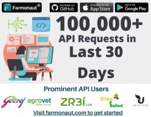
Bootstrapped Success: Farmonaut’s API Revolutionizes Agricultural Remote Sensing for All
Yes, we are achieving these milestones being completely bootstrapped. 🙂
We are developing technologies which are not only accessible to the grassroot farmers, but also are benefiting large corporates and startups.
Developing your own custom agricultural remote sensing solutions is super easy with Farmonaut® API. Simply make a few API requests and our systems will automatically generate all the satellite data (NDVI, NDWI, EVI, VARI, SOC, TCI, ETCI, NDMI, Evapotranspiration, DEM, RADAR and HYBRID) as well as the weather data for all the fields submitted by your organization.
Refer to the web page of the API and start developing your solutions!
https://lnkd.in/gg2zJ2p2
Happy Farming!
#api #farming #farm #harvest #precisionagriculture #organicfarming #greentech #technology #tech #foodsecurity #agrotech #agriculture #satellite #crophealth #farmonaut #fruit #vegetables #crops #agro #agritech #remotesensing #gis #earth #remotesensing
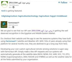
Zr3i.com: Revolutionizing Egyptian Agriculture with Farmonaut’s Satellite and Weather API
We are glad to see that our API user Zr3i.com زرعي دوت كوم is getting the well deserved recognition in the Egyptian and Middle Eastern Market.
Do checkout their website and the app to see the awesome systems they have built using Farmonaut® Satellite and Weather API. With 100s of users already using their platform for several months now, they are destined to go a long way from here.
Developing your own custom agricultural remote sensing solutions is super easy with Farmonaut API. Simply make a few API requests and our systems will automatically generate all the satellite data (NDVI, NDWI, EVI, VARI, SOC, TCI, ETCI, NDMI, Evapotranspiration, DEM, RADAR and HYBRID) as well as the weather data for all the fields submitted by your organization.
Refer to the web page of the API and start developing your solutions!
Happy Farming!
#api #farming #farm #harvest #precisionagriculture #organicfarming #greentech #technology #tech #foodsecurity #agrotech #agriculture #satellite #crophealth #farmonaut #fruit #vegetables #crops #agro #agritech #remotesensing #gis #earth #remotesensing
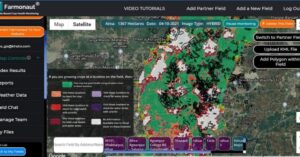
Satellite-Powered Paddy Yield Forecasting: Farmonaut’s Precision Agriculture Revolution in Bihar
In this paper, we focus on forecasting yield of paddy based on data from Sentinel-2 satellite data and Farmonaut®’s Satellite Based Crop Monitoring System available on android, iOS, and web app. The study area was rice crop in Saharsa (Bihar). The crop is in advanced stage and has vegetated fully and harvest is expected in next 10-30 days depending on crop variety of rice.
Read the full paper on the following link:
https://lnkd.in/ggfsPMkX
#farming #organicfarming #urbanfarming #fieldscouting #remotesensing #greentech #smartfarming #precisionagriculture #farm #agritech #agriculture #foodsecurity #technology #satellite #india #gis #paddy #yield
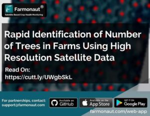
Revolutionizing Tree Counting: Farmonaut’s AI-Powered Solution Scales Precision Agriculture
At Farmonaut®, we estimated the number of trees for more than 800 farmlands totaling 1000+ hectares in area for one of our corporate clients. Not only did our system got the results pretty accurate, but also the automated system developed by us made the estimation at a faster pace and highly scalable for any future similar requirements.
Read more on the given link.
For partnerships/ large scale/ custom requirements contact us at: [email protected]
Happy farming!
#highresolution #soil #soilhealth #soc #organicmatter #farming #organicfarming #crops #urbanfarming #fieldscouting #remotesensing #greentech #smartfarming #precisionagriculture #agro #agrotech #farm #agritech #vegetables #agriculture #foodsecurity #technology #greentech #satellite #vegetation #india #gis
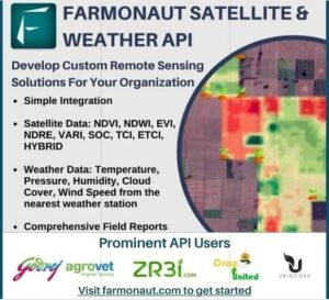
Unleash Agricultural Innovation: Harness Farmonaut’s Satellite & Weather API for Custom Remote Sensing Solutions
FARMONAUT SATELLITE & WEATHER API
Develop your own custom agricultural remote sensing solutions for your organization based upon Farmonaut Technologies. Simply make a few API requests and our systems will automatically generate all the satellite data (NDVI, NDWI, EVI, VARI, SOC, TCI, ETCI, NDMI, Evapotranspiration, DEM, RADAR and HYBRID) as well as the weather data for all the fields submitted by your organization.
Refer to the Github documentation of the API and start developing your solutions!
Happy Farming!
#api #farming #farm #harvest #precisionagriculture #organicfarming #greentech #technology #tech #foodsecurity #agrotech #agriculture #satellite #crophealth #farmonaut #fruit #vegetables #crops #agro #agritech #remotesensing #gis #earth #remotesensing43w
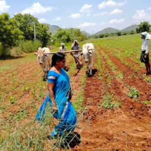
Organic Triumph: How Viswamatha Farms Leverages Remote Sensing for Sustainable Success
This year’s Auditing for Organic certification for Viswamatha Farms completed on 23rd August 2021. They have been certified as a 100% organic farm again.
Due to natural farming and PA (precision agriculture) tools they are able to get good harvest.
Remote sensing in combination with natural farming can do wonders to the agriculture sector.
By using satellite data provided by us, farmers can:
1. Reduce Chemical/Fertilizer consumption by applying them only in the locations where crop health is not good.
2. Reduce Labour costs by directing the labours only in those field areas where crop health is critical.
3. Reduce irrigation water wastage by applying proper irrigation only in those locations where plant water stress is low.
4. Increase overall yield.
5. Maintain good nutrient composition post-harvest by getting the soil testing done on the locations where Farmonaut’s SOC model has identified the level of soil organic carbon to be low.
It can not only reduce and Infact end the use of chemicals on the field but also increase the overall crop yield as well prevent the deterioration of soil nutrient composition which may happen due to the prolonged usage of chemicals on land.
To know more about the work we do, join us on our android, iOS or the web platform. For any information please feel free to contact us on: [email protected] or +91-6366026267.
#farmer #farming #satellite #vegetation #lowcost #gis #organicfarming #crops #urbanfarming #fieldscouting #remotesensing #greentech #smartfarming #precisionagriculture #agro #farm #agritech #agriculture #foodsecurity #technology #naturalfarming #precisionfarming