Revolutionizing Precision Agriculture: How Polygon Selection in Farm Field Apps is Changing the Game
In the ever-evolving world of agriculture, we at Farmonaut are constantly striving to bring innovative solutions to farmers and agricultural professionals. Today, we’re excited to dive deep into one of our most powerful features: polygon selection within farm fields. This game-changing capability is transforming the way farmers manage their land and optimize crop performance. Let’s explore how this technology is revolutionizing smart farming and precision agriculture.
Understanding Polygon Selection in Farm Field Apps
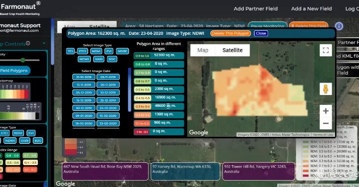
Polygon selection is a feature that allows users to select specific areas within a larger field using a farm field app. This capability is particularly useful for farmers who cultivate only portions of their land at any given time or want to focus on specific areas within their fields. Here’s how it works:
- Open your farm field app (like Farmonaut)
- Navigate to your field on the map
- Use the polygon selection tool to draw boundaries around specific areas
- Select multiple polygons within a single field
- Retrieve detailed crop performance data for each selected area
This level of precision in field management is what makes a polygon farmer so effective in today’s agricultural landscape.
The Impact of Polygon Selection on Precision Agriculture
Precision agriculture is all about applying the right treatments in the right place at the right time. Polygon selection takes this concept to a whole new level by allowing farmers to:
- Analyze smaller patches of land within a larger field
- Compare crop performance across different areas
- Identify problem spots quickly and accurately
- Apply targeted treatments to specific areas
- Optimize resource allocation based on precise data
By leveraging this technology, we’re enabling farmers to make more informed decisions and maximize their yields while minimizing waste.
Land Use Classification in Agriculture: A New Perspective
Land use classification in agriculture has traditionally been a broad-stroke approach. However, with polygon selection, we’re introducing a new level of granularity. Farmers can now:
- Classify different sections of their fields based on crop type
- Identify areas with different soil characteristics
- Map out irrigation zones with precision
- Track crop rotation patterns at a micro level
- Monitor the effectiveness of different farming practices in specific areas
This detailed classification allows for more effective land management and helps in making data-driven decisions about crop placement and rotation.
The Farmonaut Advantage: Satellite-Based Monitoring vs. Drones and IoT
While drones and IoT devices have their place in modern agriculture, our satellite-based system offers unique advantages. Here’s a comparison:
| Feature | Farmonaut Satellite System | Drone-based Monitoring | IoT-based Monitoring |
|---|---|---|---|
| Coverage Area | Vast (entire farms at once) | Limited (flight path dependent) | Limited (sensor placement dependent) |
| Frequency of Updates | Regular (based on satellite passes) | On-demand (requires manual flights) | Continuous (but localized) |
| Cost | Lower (no hardware required) | Higher (equipment and operation costs) | Higher (sensors and maintenance) |
| Ease of Use | High (accessible via app) | Moderate (requires piloting skills) | Moderate (requires setup and maintenance) |
| Data Analysis | Advanced (AI-powered insights) | Varies (depends on software) | Limited (often requires integration) |
As you can see, our satellite-based system offers comprehensive coverage, regular updates, and advanced analysis capabilities at a lower cost and with greater ease of use.
Integrating Polygon Selection with Other Smart Farming Technologies
The true power of polygon selection comes from its integration with other smart farming technologies. At Farmonaut, we’ve developed a suite of tools that work seamlessly with polygon selection:
- Satellite Imagery Analysis: Our advanced algorithms analyze multispectral satellite images to provide detailed insights into crop health, soil moisture, and more.
- AI-Powered Recommendations: By combining polygon-specific data with our AI models, we provide tailored recommendations for each section of your field.
- Weather Integration: Our system correlates local weather data with field-specific information to help you make climate-smart decisions.
- Historical Data Comparison: Compare current polygon data with historical information to track improvements and identify trends.
To explore these features and more, visit our Farmonaut app or check out our API documentation for developers.
Real-World Applications of Polygon Selection in Farming
Let’s look at some practical applications of polygon selection in everyday farming:
- Targeted Irrigation: By selecting specific polygons, farmers can apply irrigation only where it’s needed, saving water and preventing overwatering in certain areas.
- Precision Fertilization: Different sections of a field may require different nutrient levels. Polygon selection allows for tailored fertilizer application.
- Pest and Disease Management: Identify and isolate affected areas quickly, allowing for targeted treatment and preventing spread.
- Yield Estimation: Analyze smaller sections of your field to get more accurate yield estimations and plan harvesting accordingly.
- Crop Rotation Planning: Use historical data from different polygons to make informed decisions about crop rotation and soil health management.
The Future of Polygon Selection in Agriculture
As we continue to innovate, we see exciting possibilities for the future of polygon selection in agriculture:
- Integration with Autonomous Farming Equipment: Imagine tractors and harvesters that automatically adjust their operations based on polygon-specific data.
- Enhanced AI Predictions: As our AI models learn from more granular data, they’ll be able to provide even more accurate predictions and recommendations.
- 3D Mapping and Topography Analysis: Future updates may include the ability to analyze elevation and slope within polygons for better water management.
- Blockchain Integration for Traceability: Polygon-specific data could be linked to blockchain systems, providing unprecedented traceability for crops.
Getting Started with Polygon Selection on Farmonaut
Ready to revolutionize your farming practices with polygon selection? Here’s how to get started:
- Download the Farmonaut app from the Google Play Store or the Apple App Store.
- Create an account and log in.
- Add your field boundaries using our easy-to-use mapping tool.
- Start selecting polygons within your fields to analyze specific areas.
- Explore the wealth of data and insights available for each polygon.
For developers interested in integrating our polygon selection capabilities into their own applications, check out our API documentation.
Pricing and Subscription Options
We believe in making advanced agricultural technology accessible to farmers of all sizes. That’s why we offer flexible pricing options to suit your needs:
FAQ: Polygon Selection in Farm Field Apps
Q: How accurate is the polygon selection tool?
A: Our polygon selection tool is highly accurate, allowing you to define areas down to a few square meters. The precision is limited only by the resolution of the satellite imagery, which is continually improving.
Q: Can I select multiple polygons within the same field?
A: Absolutely! You can select as many polygons as you need within a single field, allowing for detailed analysis of different areas.
Q: How often is the satellite data updated?
A: Our satellite data is typically updated every 3-5 days, depending on cloud cover and satellite availability. Premium users may have access to more frequent updates.
Q: Is the polygon selection feature available on both mobile and desktop?
A: Yes, you can use the polygon selection feature on both our mobile app and web platform, providing flexibility in how you access and analyze your field data.
Q: Can I export the data from selected polygons?
A: Yes, we offer data export options in various formats, allowing you to integrate the information with other farm management tools or create custom reports.
Conclusion: Embracing the Future of Precision Agriculture
As we’ve explored throughout this post, polygon selection in farm field apps is more than just a convenient feature—it’s a transformative tool that’s reshaping the landscape of precision agriculture. By allowing farmers to focus on specific areas within their fields, we’re enabling a level of precision and efficiency that was once unimaginable.
At Farmonaut, we’re committed to continuing our innovation in this space, constantly refining our algorithms, expanding our data sources, and developing new features to meet the evolving needs of modern farmers. We believe that by combining cutting-edge technology with the wisdom of traditional farming practices, we can help create a more sustainable and productive agricultural future.
We invite you to join us on this journey. Whether you’re a small family farmer or managing vast agricultural operations, our polygon selection tools and comprehensive farm management platform are designed to help you optimize your yields, reduce waste, and make more informed decisions.
Ready to take your farming to the next level? Download the Farmonaut app today and discover the power of precision agriculture at your fingertips. Together, we can cultivate a smarter, more sustainable future for agriculture.
Happy farming, and here’s to the future of smart, polygon-powered precision agriculture!
