Empowering Farmers with Cutting-Edge Technology: The Farmonaut Revolution
In the ever-evolving landscape of agriculture, technology has emerged as a powerful ally for farmers worldwide. At the forefront of this agricultural revolution stands Farmonaut, a pioneering company that has made it its mission to bridge the technological gap between farmers and state-of-the-art farming solutions. We, at Farmonaut, are committed to putting advanced technologies directly into the hands of every farmer, regardless of the scale of their operations.
Our Vision: Transforming Agriculture Through Technology
Farmonaut is built upon a vision to democratize access to cutting-edge agricultural technologies. We believe that every farmer, whether managing a small plot or overseeing vast acres, deserves the benefits of precision agriculture. Our platform is designed to make these advanced tools not just accessible, but also affordable and user-friendly.
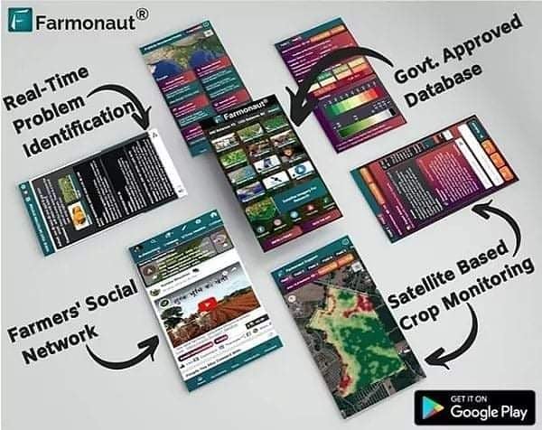
The Farmonaut Advantage: A Comprehensive Suite of Tools
In its current version, Farmonaut offers a robust set of features that cater to various aspects of modern farming. Let’s delve into these groundbreaking tools that are changing the face of agriculture:
1. Satellite-Based Crop Monitoring
At the heart of Farmonaut’s offerings is our advanced satellite-based crop monitoring system. This technology allows farmers to keep a watchful eye on their crops from above, providing invaluable insights that were once impossible to obtain without significant investment.
- Real-time Insights: Our satellite imagery provides up-to-date information on crop health, growth patterns, and potential issues.
- Wide Coverage: Unlike traditional methods, satellite monitoring can cover vast areas quickly and efficiently.
- Historical Data: Farmers can access historical satellite data to track changes over time and make informed decisions for future seasons.
2. Automated Crop Monitoring
Building on our satellite technology, we’ve developed an automated crop monitoring system that takes the guesswork out of farm management. This system continuously analyzes satellite data to provide farmers with timely alerts and insights.
- Anomaly Detection: Our AI algorithms can identify potential issues such as pest infestations or nutrient deficiencies before they become visible to the naked eye.
- Growth Stage Tracking: The system automatically tracks crop growth stages, helping farmers optimize their interventions and resource allocation.
- Yield Prediction: By analyzing historical data and current conditions, our system can provide accurate yield predictions, allowing for better planning and resource management.
3. Crop Health Status
Understanding the health of crops is crucial for maximizing yield and minimizing losses. Our crop health status feature provides farmers with a comprehensive overview of their fields’ well-being.
- NDVI Analysis: We use Normalized Difference Vegetation Index (NDVI) to assess crop vigor and density.
- Stress Detection: Early identification of crop stress allows for timely interventions, potentially saving entire harvests.
- Nutrient Management: Our system helps in identifying areas that may require additional nutrients, enabling targeted fertilizer application.
4. Vegetation Water Level and Evapotranspiration
Water management is a critical aspect of successful farming. Our platform provides detailed insights into vegetation water level and evapotranspiration, helping farmers optimize their irrigation strategies.
- Soil Moisture Analysis: We can estimate soil moisture levels across fields using advanced satellite data.
- Evapotranspiration Tracking: Understanding the rate at which water is transferred from the land to the atmosphere helps in precise irrigation planning.
- Water Stress Alerts: Our system sends timely alerts when crops are at risk of water stress, allowing for prompt action.
5. Satellite Imagery Access for Research
We understand the importance of research in advancing agricultural practices. That’s why we offer satellite imagery access for research purposes, supporting scientists and agricultural experts in their work.
- High-Resolution Imagery: Access to detailed satellite images for in-depth analysis.
- Historical Data: Researchers can study long-term trends and changes in agricultural landscapes.
- API Access: We provide API access for seamless integration with research tools and platforms. Learn more about our API at Farmonaut Satellite API.
How Farmonaut Compares to Traditional Monitoring Methods
While drone and IoT-based farm monitoring systems have their merits, Farmonaut’s satellite-based system offers several unique advantages:
| Feature | Farmonaut Satellite System | Drone-based Monitoring | IoT-based Monitoring |
|---|---|---|---|
| Coverage Area | Vast areas (thousands of acres) | Limited by flight time and regulations | Limited by sensor placement |
| Data Frequency | Regular updates (varies by plan) | Dependent on manual flights | Continuous but localized |
| Initial Setup Cost | Low (subscription-based) | High (drone purchase, training) | Moderate to High (sensors, network) |
| Maintenance | Minimal (cloud-based system) | Regular (drone maintenance, battery replacement) | Regular (sensor calibration, replacement) |
| Scalability | Highly scalable | Limited by equipment and manpower | Requires additional sensor deployment |
| Weather Dependency | Less affected by local weather | Highly dependent on weather conditions | Generally weather-independent |
| Data Analysis | Advanced AI-powered analysis | Requires separate analysis tools | Often limited to specific parameters |
The Farmonaut Experience: User-Friendly and Accessible
We’ve designed Farmonaut to be as user-friendly and accessible as possible. Our platform is available through web and mobile applications, ensuring that farmers can access vital information wherever they are.
- Mobile App: Download our app for on-the-go access to all Farmonaut features.
- Web Platform: Access Farmonaut through any web browser for a full-featured experience. Visit Farmonaut Web Platform
- API Integration: We offer comprehensive API access for developers and businesses looking to integrate Farmonaut’s powerful features into their own systems. View our API Documentation
Empowering Farmers, One Field at a Time
At Farmonaut, we believe that by putting advanced technologies in the hands of farmers, we can revolutionize agriculture and contribute to global food security. Our platform is more than just a set of tools; it’s a gateway to smarter, more sustainable farming practices.
We’re committed to continuous improvement and innovation. Your feedback and suggestions play a crucial role in shaping the future of Farmonaut. Together, we can create a more efficient, productive, and sustainable agricultural sector.
Frequently Asked Questions (FAQ)
Q: What is Farmonaut?
A: Farmonaut is an advanced agricultural technology platform that uses satellite imagery, AI, and machine learning to provide farmers with real-time insights and tools for precision agriculture.
Q: How does satellite-based crop monitoring work?
A: Satellite-based crop monitoring uses multispectral imagery from satellites to analyze various aspects of crop health, including vegetation indices, water stress, and growth patterns. This data is processed and presented to farmers in an easy-to-understand format.
Q: Is Farmonaut suitable for small-scale farmers?
A: Yes, Farmonaut is designed to be accessible and beneficial for farmers of all scales, from small holdings to large commercial farms. Our pricing plans are flexible to accommodate different farm sizes and needs.
Q: How often is the satellite imagery updated?
A: The frequency of satellite imagery updates depends on the specific plan you choose. Generally, we offer updates ranging from daily to weekly, ensuring you have access to recent data for informed decision-making.
Q: Can Farmonaut help me reduce water usage?
A: Absolutely. Our vegetation water level and evapotranspiration monitoring features help optimize irrigation by providing insights into soil moisture and crop water needs, potentially leading to significant water savings.
Q: Is internet connectivity required to use Farmonaut?
A: While internet connectivity is required to receive real-time updates and access the full range of features, our mobile app allows for some offline functionality, ensuring you can access critical information even in areas with limited connectivity.
Q: How accurate is the crop health status feature?
A: Our crop health status feature utilizes advanced AI algorithms and high-resolution satellite imagery, providing a high level of accuracy. However, it’s important to note that on-ground verification can further enhance the accuracy of insights.
Q: Can I integrate Farmonaut with other farming tools I use?
A: Yes, Farmonaut offers API access, allowing for integration with various other agricultural tools and platforms. Our developer documentation provides detailed information on how to integrate Farmonaut’s features into your existing systems.
Q: Is my farm data secure with Farmonaut?
A: We take data security very seriously. All farm data is encrypted and stored securely in compliance with international data protection standards. We do not share your personal or farm-specific data with third parties without your explicit consent.
Q: How can I get support if I have questions or issues?
A: We offer multiple support channels, including in-app help, email support, and our farmers’ discussion forum where you can get help from both our team and fellow farmers. Premium plans also include priority support options.
At Farmonaut, we’re not just providing tools; we’re nurturing a community of forward-thinking farmers who are embracing technology to revolutionize agriculture. Join us in this exciting journey towards smarter, more sustainable farming. Together, we can cultivate a better future for agriculture and food security worldwide.
Remember, the future of farming is here, and it’s powered by Farmonaut. Let’s grow together!
