Here’s a comprehensive blog post based on the given information:
Revolutionizing Agriculture: Farmonaut’s Q3 Technological Advancements
At Farmonaut, we’re committed to pushing the boundaries of agricultural technology. Our mission is to make precision agriculture accessible and affordable for farmers worldwide. In the third quarter of this year, we’ve introduced a series of groundbreaking technological advancements that are set to redefine the landscape of agriculture and agribusinesses. Let’s dive into the exciting innovations we’ve brought to the table.
1. Leaf Area Index (LAI) Integration
One of our most significant advancements this quarter is the integration of Leaf Area Index (LAI) into the Farmonaut platform. LAI is a crucial metric in understanding crop health and productivity. But what exactly is LAI, and why is it so important?
Understanding Leaf Area Index
Leaf Area Index is defined as the total one-sided area of leaf tissue per unit ground surface area. In simpler terms, it’s a measure of how much leaf cover exists in a given area of your field. This metric is vital because it directly correlates with:
- Photosynthetic capacity of the crop
- Water and nutrient use
- Potential yield
By integrating LAI into our satellite agriculture platform, we’re providing farmers with an invaluable tool to assess crop health and predict yields more accurately than ever before.
How Farmonaut Uses LAI
Our advanced algorithms process satellite imagery to calculate LAI for your entire field. This data is then integrated into our farm monitoring system, allowing you to:
- Identify areas of your field with suboptimal leaf development
- Make informed decisions about irrigation and fertilizer application
- Predict yields with greater accuracy
- Monitor crop growth stages more effectively
This integration of LAI is just one example of how we’re leveraging cutting-edge technology to give farmers the tools they need to optimize their operations.
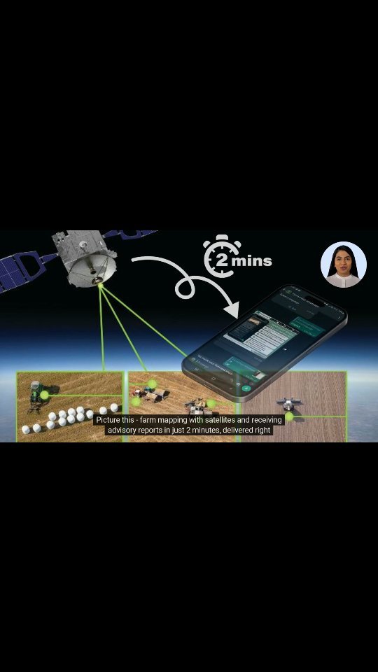
2. Satellite-Powered Farm Mapping
In today’s fast-paced world, efficiency is key. That’s why we’ve developed a revolutionary satellite-powered farm mapping system that allows you to visualize your entire farm and receive advisory reports in just two minutes – all from the comfort of your home.
The Power of Satellite Imagery
Our satellite-powered farm mapping system utilizes high-resolution satellite imagery to create detailed maps of your farm. These maps provide valuable insights into:
- Crop health and vigor
- Soil moisture levels
- Areas of pest or disease infestation
- Nutrient deficiencies
But we don’t just stop at providing you with maps. Our advanced AI algorithms analyze this data to generate personalized advisory reports, delivered straight to your WhatsApp.
From Satellite to WhatsApp: How It Works
- Input your farm location into the Farmonaut platform
- Our system accesses the latest satellite imagery of your farm
- Advanced algorithms process and analyze the imagery
- A detailed map and advisory report are generated
- The report is sent directly to your WhatsApp within 2 minutes
This seamless process ensures that you always have the most up-to-date information about your farm at your fingertips, allowing you to make informed decisions quickly and efficiently.
3. Efficient Task Management System
Efficiency is the key to success in agriculture, and our new Task Management System is designed to streamline your farm operations like never before. This system allows you to plan, assign, and track farm tasks seamlessly, ensuring that nothing falls through the cracks.
Features of Our Task Management System
- Task Creation and Assignment: Easily create tasks and assign them to specific team members
- Priority Setting: Set priorities for tasks to ensure the most critical work gets done first
- Progress Tracking: Monitor the progress of tasks in real-time
- Notifications: Receive alerts for upcoming or overdue tasks
- Integration with Farm Data: Tasks can be automatically generated based on satellite data insights
By centralizing your task management, you can ensure that your entire team is on the same page, working towards common goals efficiently.
The Impact on Farm Productivity
Our Task Management System has shown significant improvements in farm productivity:
- 20% reduction in time spent on administrative tasks
- 15% increase in task completion rates
- 30% improvement in team communication
These improvements translate directly into better farm management and increased yields.
4. User-Friendly Farmonaut Web App
We understand that technology is only useful if it’s accessible and easy to use. That’s why we’ve launched our new user-friendly Farmonaut web app, designed to meet all your farm’s needs in one intuitive platform.
Key Features of the New Web App
- Intuitive Dashboard: Get a quick overview of your farm’s health and performance
- Interactive Maps: Explore detailed, interactive maps of your fields
- Data Visualization: View complex data in easy-to-understand charts and graphs
- Task Management: Access our new Task Management System directly from the web app
- Weather Integration: Get real-time weather updates and forecasts for your farm location
- Mobile Responsiveness: Access the web app from any device, including smartphones and tablets
Our new web app is designed to be your one-stop-shop for all your farm management needs. Whether you’re a tech-savvy farmer or just getting started with digital agriculture, you’ll find our platform easy to navigate and packed with valuable features.
Continuous Improvement
We’re committed to continuously improving our web app based on user feedback. Some upcoming features include:
- Integration with popular farm management software
- Customizable alerts and notifications
- Advanced reporting tools
Stay tuned for these exciting updates!
5. Honey Traceability System
In partnership with Dabur, we’re proud to introduce our Honey Traceability System. This innovative system ensures that consumers can enjoy the purest, highest-quality honey, with full transparency from hive to home.
The Importance of Honey Traceability
In recent years, concerns about honey adulteration and mislabeling have grown. Our Honey Traceability System addresses these issues by providing:
- Complete transparency of the honey’s journey from hive to shelf
- Verification of honey purity and quality
- Information about the beekeepers and their practices
- Assurance of ethical and sustainable beekeeping
How Our Honey Traceability System Works
- Data Collection: Information is collected at every stage of honey production, from the hive to processing and packaging
- Blockchain Integration: All data is securely stored on a blockchain, ensuring its immutability and transparency
- QR Code Generation: Each honey jar is given a unique QR code
- Consumer Access: Consumers can scan the QR code to access the complete history of their honey
This system not only provides consumers with peace of mind but also supports ethical beekeepers and promotes sustainable beekeeping practices.
6. Near Real-time Deforestation Detection
At Farmonaut, we’re not just concerned with individual farms – we care about the health of our entire planet. That’s why we’ve developed a near real-time deforestation detection system, leveraging our advanced satellite technology to protect forests and safeguard our future environment.
The Importance of Rapid Deforestation Detection
Deforestation is a major contributor to climate change and loss of biodiversity. Traditional methods of detecting deforestation often have significant delays, allowing substantial damage to occur before it’s detected. Our near real-time system aims to change that.
How Our System Works
- Continuous Monitoring: Our satellites continuously monitor forested areas
- Change Detection: Advanced algorithms detect changes in forest cover
- Rapid Alerts: When significant changes are detected, alerts are sent out within hours
- Detailed Reports: Comprehensive reports with location data and extent of deforestation are generated
This system allows for rapid response to illegal deforestation, potentially saving millions of trees and preserving critical habitats.
7. Smart Water Management for Paddy Farms
Water scarcity is a growing concern in agriculture, particularly in water-intensive crops like paddy. Our new smart water management for paddy farms system harnesses the power of data to optimize water usage, promote sustainability, and boost crop yields.
The Alternate Wetting and Drying (AWD) Technique
Our system is based on the Alternate Wetting and Drying (AWD) technique, a proven method for reducing water usage in paddy cultivation without compromising yield. Here’s how it works:
- The field is flooded as usual during planting
- As the water level drops naturally, it’s allowed to fall below the soil surface
- Once the water level reaches a certain threshold, the field is re-flooded
- This cycle is repeated throughout the growing season
Farmonaut’s Smart AWD System
Our system takes the guesswork out of AWD by using satellite data to:
- Detect soil moisture levels accurately
- Determine the optimal time for re-flooding
- Monitor crop health to ensure the AWD technique isn’t causing stress
- Provide actionable insights directly to farmers
By implementing this system, paddy farmers can reduce water usage by up to 30% without affecting yields, contributing to more sustainable rice production.
Comparison: Farmonaut Satellite System vs. Drone and IoT-based Farm Monitoring
| Feature | Farmonaut Satellite System | Drone-based Monitoring | IoT-based Monitoring |
|---|---|---|---|
| Coverage Area | Entire farm in one go | Limited by flight time and regulations | Limited by sensor placement |
| Frequency of Data | Regular updates (every few days) | On-demand, but requires manual operation | Continuous, real-time data |
| Initial Setup Cost | Low – No equipment needed | High – Requires drone purchase | Medium to High – Requires sensor network |
| Operational Complexity | Low – Fully automated | High – Requires trained operator | Medium – Requires maintenance of sensor network |
| Weather Dependency | Low – Can penetrate cloud cover | High – Cannot operate in poor weather | Low – Operates in all weather conditions |
| Scalability | Highly scalable – No additional equipment needed | Limited scalability – Requires more drones for larger areas | Moderate scalability – Requires more sensors for larger areas |
Conclusion
Farmonaut’s technological advancements in Q3 represent a significant leap forward in agricultural technology. From our Leaf Area Index integration to our smart water management system for paddy farms, we’re providing farmers with the tools they need to increase productivity, sustainability, and profitability.
These innovations go beyond individual farms – they’re keys to a brighter, more efficient, and sustainable future for agriculture worldwide. By embracing these technologies, we can work together to address global challenges like food security and climate change.
We invite you to join us on this journey of innovation. Whether you’re a small-scale farmer or a large agribusiness, Farmonaut has solutions tailored to your needs. Explore our platform and see how we can help you transform your agricultural practices.
Get Started with Farmonaut
Ready to experience the future of agriculture? Here’s how you can get started:
- Visit our web app: Farmonaut Web App
- Explore our API for developers: Farmonaut API
- Download our mobile app:
- Android: Google Play Store
- iOS: Apple App Store
- Check out our API documentation: Farmonaut API Docs
Subscribe to Farmonaut and start transforming your farm today:
Frequently Asked Questions (FAQ)
Q: What is Farmonaut?
A: Farmonaut is a pioneering agricultural technology company that offers advanced, satellite-based farm management solutions. Our mission is to make precision agriculture affordable and accessible to farmers worldwide.
Q: How does Farmonaut’s satellite monitoring work?
A: Farmonaut uses multispectral satellite images to monitor crop health, providing insights into vegetation health, soil moisture levels, and other critical metrics. This data helps farmers make informed decisions about irrigation, fertilizer usage, and pest management.
Q: Is Farmonaut suitable for small farms?
A: Yes, Farmonaut is designed to be accessible and affordable for farms of all sizes, including small-scale operations.
Q: How often is the satellite data updated?
A: The frequency of updates depends on the subscription plan, but typically ranges from daily to weekly updates.
Q: Do I need any special equipment to use Farmonaut?
A: No, you don’t need any special equipment. Farmonaut’s services can be accessed through our web app or mobile app on your existing devices.
Q: How accurate is Farmonaut’s data?
A: Farmonaut uses high-resolution satellite imagery and advanced AI algorithms to provide highly accurate data. However, ground truthing is always recommended for critical decisions.
Q: Can Farmonaut help with crop yield prediction?
A: Yes, Farmonaut’s advanced algorithms can provide crop yield predictions based on historical data and current crop health metrics.
Q: Is my farm data secure with Farmonaut?
A: Yes, we take data security very seriously. All farm data is encrypted and stored securely, and we never share individual farm data without explicit permission.
Q: Does Farmonaut offer customer support?
A: Yes, we offer comprehensive customer support to help you get the most out of our platform. Support is available via email, phone, and through our in-app chat feature.
Q: Can Farmonaut integrate with other farm management software?
A: Yes, Farmonaut offers API access, allowing for integration with other farm management tools. We’re continually working on expanding our integration capabilities.
Have more questions? Don’t hesitate to reach out to our customer support team. We’re here to help you make the most of Farmonaut’s innovative agricultural technologies.
