Revolutionizing Agriculture: Farmonaut’s Satellite-Based Crop Health Monitoring System
At Farmonaut, we’re proud to be at the forefront of agricultural innovation, bringing cutting-edge technology to farmers’ fingertips. Our latest Instagram post showcases the power of our satellite-based crop health monitoring system, demonstrating how we’re transforming the way farmers manage their fields and optimize their yields.
Understanding the Power of Satellite Imagery in Agriculture
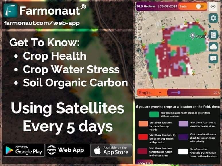
The image we shared on Instagram is more than just a pretty picture – it’s a powerful tool that provides invaluable insights into crop health and water stress. Let’s break down what this image tells us about a farmer’s field in Rattanpura, Rajasthan:
- Green areas: These indicate locations with good crop health and optimal water stress levels. This is what farmers aim for across their entire field.
- Orange areas: These highlight locations with poor crop health. These areas require immediate attention and intervention.
- Purple areas: These show locations experiencing bad water stress. This information is crucial for irrigation management.
- White areas: These represent areas affected by cloud cover, which can temporarily obscure satellite data.
This single image encapsulates a wealth of information that would traditionally require extensive field scouting and manual data collection. With Farmonaut’s technology, farmers can access this data instantly, allowing for rapid decision-making and targeted interventions.
The Science Behind Satellite-Based Crop Monitoring
Our satellite-based crop health monitoring system relies on advanced remote sensing technologies and sophisticated algorithms to provide accurate, timely information about crop conditions. At the heart of this system are various vegetation indices, including:
- NDVI (Normalized Difference Vegetation Index): This index is crucial for assessing crop health and vigor.
- NDRE (Normalized Difference Red Edge): This provides insights into chlorophyll content and nitrogen status.
- EVI (Enhanced Vegetation Index): This offers improved sensitivity in high biomass regions.
- VARI (Visible Atmospherically Resistant Index): This is useful for estimating vegetation fraction.
- NDWI (Normalized Difference Water Index): This helps in assessing water content in vegetation.
How Does NDVI Work?
NDVI is one of the most widely used vegetation indices in remote sensing. It works by measuring the difference between near-infrared (which vegetation strongly reflects) and red light (which vegetation absorbs). The formula for NDVI is:
NDVI = (NIR – Red) / (NIR + Red)
Where NIR is the near-infrared reflectance and Red is the red reflectance. NDVI values range from -1 to +1, with higher values indicating healthier vegetation.
NDVI and NDWI: A Powerful Combination
While NDVI focuses on vegetation health, NDWI provides crucial information about water content in leaves and soil moisture. By combining these indices, we can give farmers a comprehensive view of their crops’ health and water status. This dual approach is particularly valuable in regions prone to water stress or during critical growth stages of water-sensitive crops like cotton.
Cotton Crop Duration and Monitoring
Cotton is a crucial crop in many parts of India, including Rajasthan. The cotton crop duration typically ranges from 150 to 180 days, depending on the variety and local conditions. Throughout this period, regular monitoring is essential to ensure optimal growth and yield.
Our satellite-based system allows farmers to track their cotton crop’s progress throughout its entire lifecycle, from emergence to harvest. This continuous monitoring helps in:
- Detecting early signs of stress or disease
- Optimizing irrigation schedules
- Planning timely interventions for pest control
- Predicting yield potential
- Determining the best time for harvest
Dealing with Cloud Cover Percentage
One challenge in satellite-based monitoring is cloud cover, which can obscure the view of crops. Our system accounts for this by:
- Using multiple satellite passes to increase the chances of clear imagery
- Employing advanced algorithms to interpolate data in cloud-affected areas
- Providing historical data to fill gaps during prolonged cloudy periods
- Offering transparency about cloud cover percentage in our reports
We typically aim for imagery with less than 10% cloud cover for optimal analysis, but our system can still provide valuable insights even with higher cloud cover percentages.
Farmonaut’s Advanced Features
While our basic app provides essential insights, users who require more in-depth analysis can easily switch to the advanced version. This version offers:
- Detailed NDVI, NDRE, EVI, VARI, and NDWI analyses
- Historical data comparisons
- Custom alert settings for specific field conditions
- Integration with weather forecasts for predictive analysis
- Export capabilities for data analysis in other software
To access these advanced features, users simply need to tap a button within the app. This seamless transition ensures that farmers of all technical levels can benefit from our technology.
Community and Collaboration
At Farmonaut, we believe in the power of community. Our app isn’t just a tool for individual farm management; it’s a platform for collaboration and knowledge sharing. Through our app, farmers can:
- Discuss issues with other farmers facing similar challenges
- Share success stories and best practices
- Collaborate on regional farming strategies
- Access expert advice from agronomists and agricultural scientists
- Participate in community-driven research projects
This collaborative approach helps create a supportive ecosystem where farmers can learn from each other and collectively address the challenges of modern agriculture.
Farmonaut vs. Drone and IoT-Based Farm Monitoring
While drone and IoT-based solutions have their place in precision agriculture, Farmonaut’s satellite-based system offers several distinct advantages:
| Feature | Farmonaut Satellite System | Drone-Based Monitoring | IoT-Based Monitoring |
|---|---|---|---|
| Coverage Area | Unlimited | Limited by flight time and regulations | Limited by sensor placement |
| Frequency of Data Collection | Regular (every few days) | As needed, but labor-intensive | Continuous, but spatially limited |
| Initial Investment | Low | High (drone purchase, training) | Medium to High (sensors, network setup) |
| Operational Costs | Low | Medium (maintenance, pilot fees) | Low to Medium (maintenance, data plans) |
| Ease of Use | High (app-based interface) | Medium (requires skilled operator) | Medium (requires technical setup) |
| Data Processing | Automated | Often requires manual processing | Automated, but limited in scope |
| Scalability | Highly scalable | Limited by equipment and manpower | Scalable, but with increasing complexity |
Getting Started with Farmonaut
Ready to revolutionize your farming practices? Getting started with Farmonaut is easy:
- Download our app from the Google Play Store or the Apple App Store.
- Create an account and verify your email.
- Add your field boundaries using our intuitive mapping tool.
- Choose your subscription plan based on your needs.
- Start receiving insights about your crops within days!
For those who prefer a web-based interface, our web app offers the same powerful features accessible from any browser.
Developer Integration
For agtech companies and developers looking to integrate satellite-based crop monitoring into their own applications, we offer a robust API. Our Satellite API and Weather API provide access to our comprehensive dataset, allowing for seamless integration of Farmonaut’s technology into third-party solutions.
The Future of Farming with Farmonaut
As we continue to develop and refine our technology, we’re excited about the future possibilities for precision agriculture. Some areas we’re exploring include:
- Integration of machine learning for predictive crop modeling
- Enhanced disease detection capabilities
- Automated crop yield estimation
- Integration with farm management software for comprehensive farm planning
- Development of crop-specific algorithms for even more precise insights
Our goal is to continue pushing the boundaries of what’s possible in agricultural technology, always with the farmer’s needs at the forefront of our innovations.
Conclusion
Farmonaut’s satellite-based crop health monitoring system is more than just a technological advancement – it’s a revolution in how we approach farming. By providing farmers with easy access to detailed, actionable insights about their crops, we’re empowering them to make informed decisions, optimize their resources, and ultimately, produce more sustainable and profitable harvests.
Whether you’re managing a small family farm or overseeing large-scale agricultural operations, Farmonaut has the tools you need to take your farming to the next level. Join us in shaping the future of agriculture – download our app today and experience the power of satellite-based crop monitoring for yourself.
Happy Farming! 🌱🛰️🚜
FAQ Section
Q: How often does Farmonaut update its satellite imagery?
A: We typically provide updates every 3-5 days, depending on satellite availability and cloud cover conditions.
Q: Can Farmonaut’s system work for all types of crops?
A: Yes, our system is designed to work with a wide variety of crops, including grains, fruits, vegetables, and cash crops like cotton.
Q: Is an internet connection required to use the Farmonaut app?
A: An internet connection is required to receive updates and new imagery. However, once data is downloaded, many features can be accessed offline.
Q: How accurate is the crop health information provided by Farmonaut?
A: Our system has been extensively tested and validated, with accuracy rates typically exceeding 90% for crop health assessments.
Q: Can Farmonaut’s system detect specific diseases or pests?
A: While our current system focuses on overall crop health and stress detection, we are developing more specific disease and pest detection capabilities for future updates.
Q: Is training required to use the Farmonaut app?
A: Our app is designed to be user-friendly and intuitive. While we offer tutorials and support, most users can start benefiting from the app with minimal training.
Q: How does Farmonaut protect user data and privacy?
A: We take data security seriously. All user data is encrypted, and we adhere to strict privacy policies to ensure your farm information remains confidential.
Q: Can Farmonaut’s system be integrated with other farm management software?
A: Yes, we offer API access for integration with other farm management tools. Contact our developer support team for more information.
Q: What support options are available for Farmonaut users?
A: We offer in-app support, email assistance, and phone support for our subscribers. Our team is dedicated to helping you make the most of our technology.
Q: How does cloud cover affect the accuracy of Farmonaut’s data?
A: While heavy cloud cover can temporarily impact data collection, our system uses multiple satellite passes and advanced algorithms to minimize these effects and provide consistent, reliable data.
Have more questions? Don’t hesitate to reach out to our support team. We’re here to help you make the most of Farmonaut’s powerful agricultural technology!
