Farmonaut: Revolutionizing Agriculture with Geospatial Technologies
In the ever-evolving landscape of agriculture, technological advancements are playing a pivotal role in transforming traditional farming practices. Among these innovations, geospatial technologies have emerged as a game-changer, offering farmers unprecedented insights into their fields and crops. At the forefront of this agricultural revolution is Farmonaut, a pioneering company harnessing the power of satellite technology to empower farmers worldwide.
The Digital Revolution in Agriculture
With the digital revolution sweeping across India and the globe, numerous technological advancements have found their way into the agriculture domain. Tech-savvy entrepreneurs and innovators have taken up the responsibility to reform this often-neglected field by providing farmers with viable, cutting-edge solutions.
Geospatial technology, an evolving field that encompasses Geographic Information Systems (GIS), Remote Sensing (RS), and Global Positioning Systems (GPS), has become the need of the hour to ensure exponential growth in agriculture. Farmonaut’s Satellite-Based Crop Health Monitoring System is built to put this powerful technology into the hands of each and every farmer in the most economical way possible.
Farmonaut’s Mission: Democratizing Remote Sensing
Farmonaut’s primary objective is to break the cost barrier and help democratize remote sensing in the farming community. We provide an on-the-go, always-ready platform for field monitoring through satellites. Our system is accessible through web, Android, and iOS apps, making it convenient for farmers to access crucial data anytime, anywhere.
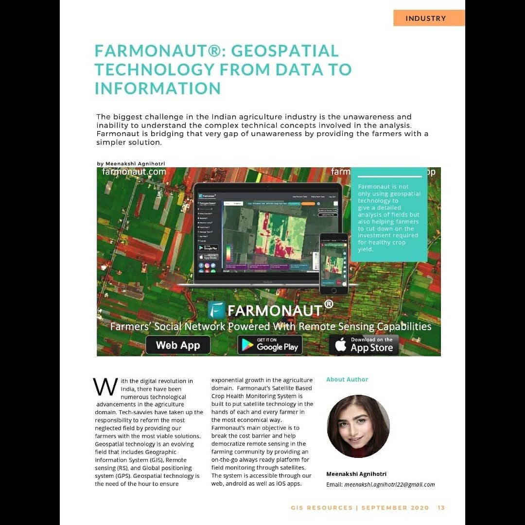
The biggest challenge in the Indian agriculture industry has been the unawareness and inability to understand complex technical concepts involved in data analysis. Farmonaut is bridging this gap by providing farmers with a simpler, more intuitive solution.
How Farmonaut Works
Farmonaut enables farmers to monitor their fields remotely through satellites, providing them with detailed analysis of:
- Crop health
- Vegetation water stress
- Soil organic carbon content
Our platform uses various indices and technologies to generate actionable insights:
1. Normalized Difference Vegetation Index (NDVI)
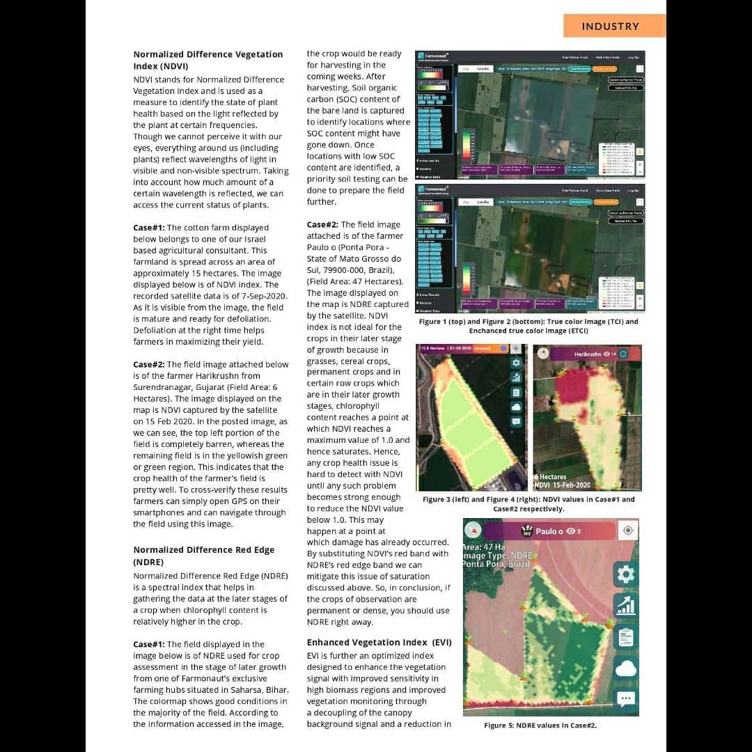
NDVI is used as a measure to identify the state of plant health based on the light reflected by plants at certain frequencies. It helps farmers assess crop vigor and identify potential issues early on.
2. Normalized Difference Red Edge (NDRE)
NDRE is a spectral index that helps in gathering data at the later stages of a crop when chlorophyll content is relatively higher. It’s particularly useful for assessing crop health in dense vegetation where NDVI might saturate.
3. Enhanced Vegetation Index (EVI)
EVI is an optimized index designed to enhance the vegetation signal with improved sensitivity in high biomass regions. It provides better vegetation monitoring by accounting for canopy background signals and reducing atmospheric influences.
4. Normalized Difference Water Index (NDWI)
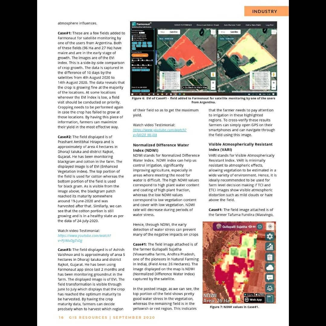
NDWI helps control irrigation by providing insights into plant water content. It’s especially useful in areas where meeting water needs is challenging.
5. Visible Atmospherically Resistant Index (VARI)
VARI is minimally affected by atmospheric effects, allowing vegetation to be estimated in a wide variety of environments. It’s ideal for farm-level decision-making when true color images show visible atmospheric distortion such as mild clouds or haze above the field.
6. Soil Organic Carbon (SOC)
SOC is a measurable component of soil organic matter that indicates better health and yield potential of land. Farmonaut creates SOC images with color maps showing the percentage of organic matter present in selected fields.
Benefits of Using Farmonaut
By leveraging Farmonaut’s satellite-based analysis, farmers can:
- Reduce chemical/fertilizer consumption by applying it only where crop health is poor
- Cut labor costs by directing workers only to areas where crop health is critical
- Minimize irrigation water wastage by applying proper irrigation only where plant water stress is high
- Increase overall yield
- Maintain good nutrient composition post-harvest by targeting soil testing based on SOC analysis
On average, using Farmonaut can help farmers save approximately 30% on expenses related to chemicals, insecticides, pesticides, and plant growth regulators.
Farmonaut vs. Drone and IoT-based Farm Monitoring
| Feature | Farmonaut Satellite System | Drone Monitoring | IoT-based Monitoring |
|---|---|---|---|
| Coverage Area | Large scale (Entire farms) | Limited (Flight restrictions) | Limited (Sensor placement) |
| Cost | Low | High (Equipment + Operator) | Medium to High (Sensors + Network) |
| Frequency of Data | Regular (Based on satellite passes) | On-demand (Weather dependent) | Continuous |
| Ease of Use | High (No on-site equipment needed) | Medium (Requires skilled operator) | Medium (Requires setup and maintenance) |
| Data Processing | Automated and fast | Can be time-consuming | Real-time but limited parameters |
Success Stories: Viswamatha Farms
Viswamatha Farms, pioneers in natural farming in India, have been using Farmonaut’s Satellite-Based Crop Health Monitoring System since September 2019. They cultivate pulses, spices, groundnut, vegetables, and fruits on 26 hectares of land.
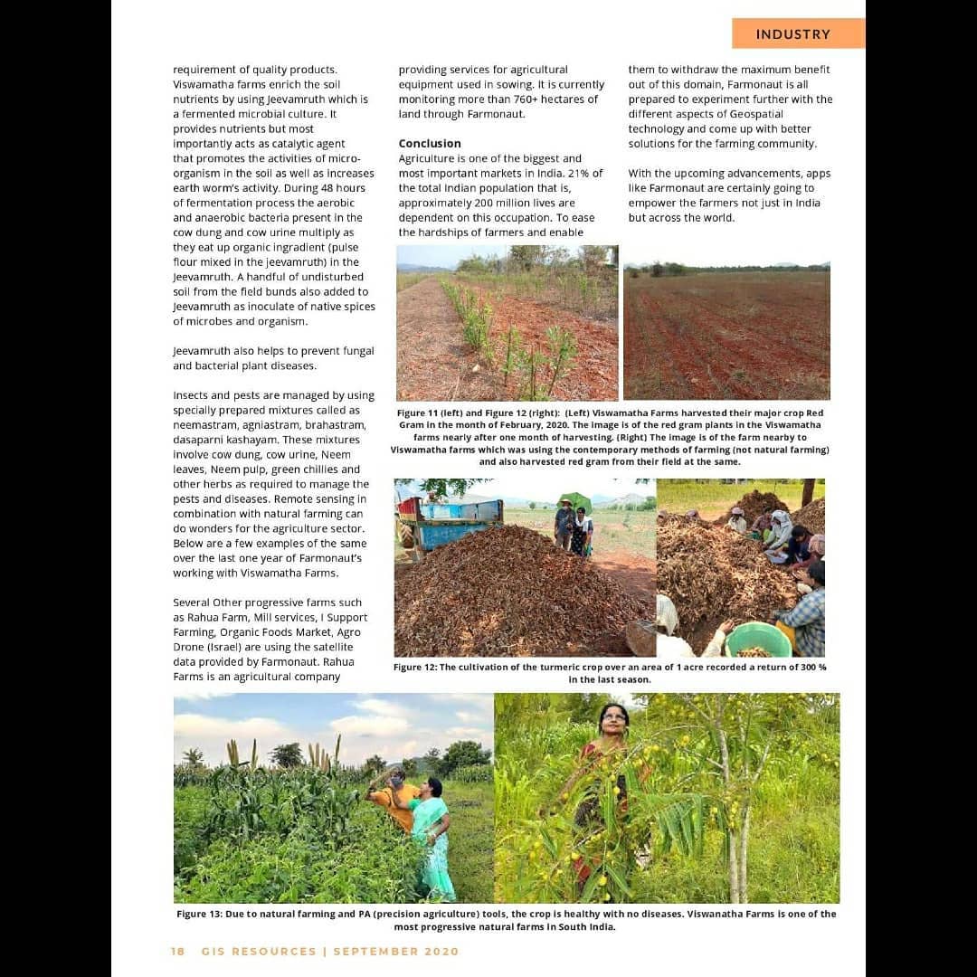
By combining natural farming practices with Farmonaut’s precision agriculture tools, Viswamatha Farms has achieved remarkable results:
- Healthier crops with minimal disease occurrence
- 300% return on investment for turmeric cultivation on 1 acre
- Improved soil health and biodiversity
How to Get Started with Farmonaut
Ready to revolutionize your farming practices? Here’s how you can get started with Farmonaut:
- Download the Farmonaut app:
- Sign up and add your fields
- Start receiving satellite-based insights
- For advanced users, integrate our API into your existing systems: Farmonaut API
Frequently Asked Questions (FAQ)
1. How often is satellite data updated?
Satellite data is typically updated every 5-7 days, depending on cloud cover and satellite availability.
2. Can Farmonaut work for small farms?
Yes, Farmonaut is designed to be cost-effective even for small farms under 5 acres.
3. Does Farmonaut require any special equipment on my farm?
No, Farmonaut uses satellite data, so no on-farm equipment is necessary.
4. In which languages is Farmonaut available?
Farmonaut is available in over 50 languages to cater to farmers worldwide.
5. Can Farmonaut help with organic farming?
Absolutely! Farmonaut’s insights can be particularly valuable for organic farmers to monitor crop health without chemical inputs.
Conclusion
Farmonaut is at the forefront of agricultural innovation, making precision farming accessible and affordable for farmers worldwide. By harnessing the power of satellite technology and advanced data analysis, we’re empowering farmers to make informed decisions, increase yields, and practice sustainable agriculture.
Join the agricultural revolution today! Visit Farmonaut to learn more and get started with satellite-based farm monitoring.
For developers interested in integrating our powerful API into their agricultural solutions, check out our API documentation.
