Mastering Satellite Vegetation Indices: MNDWI, MSAVI, and NDMI Formulas for Sentinel-2 Imagery in Precision Agriculture
In the ever-evolving world of precision agriculture, satellite-based vegetation indices have become indispensable tools for farmers, agronomists, and researchers. At Farmonaut, we’re at the forefront of leveraging these advanced technologies to revolutionize farming practices. Today, we’re diving deep into three crucial vegetation indices: the Modified Normalized Difference Water Index (MNDWI), the Modified Soil-Adjusted Vegetation Index (MSAVI), and the Normalized Difference Moisture Index (NDMI). We’ll explore their formulas, applications, and how they can be utilized with Sentinel-2 imagery to enhance agricultural decision-making.
Understanding Vegetation Indices in Precision Agriculture
Before we delve into the specific indices, let’s establish a foundational understanding of vegetation indices and their importance in modern agriculture.
Vegetation indices are quantitative measurements derived from mathematical combinations of spectral bands. These indices are designed to enhance the vegetation signal in satellite imagery while minimizing the influence of soil background, atmospheric effects, and other non-vegetation related factors. By utilizing different portions of the electromagnetic spectrum, these indices provide valuable insights into various aspects of vegetation health, water content, and overall ecosystem dynamics.
In precision agriculture, these indices serve several critical functions:
- Crop health monitoring
- Yield prediction
- Stress detection (water stress, nutrient deficiencies, pest infestations)
- Biomass estimation
- Irrigation management
- Land use classification
Now, let’s explore the MNDWI, MSAVI, and NDMI indices in detail, focusing on their formulas for Sentinel-2 imagery and their applications in precision agriculture.
Modified Normalized Difference Water Index (MNDWI)
MNDWI Formula for Sentinel-2
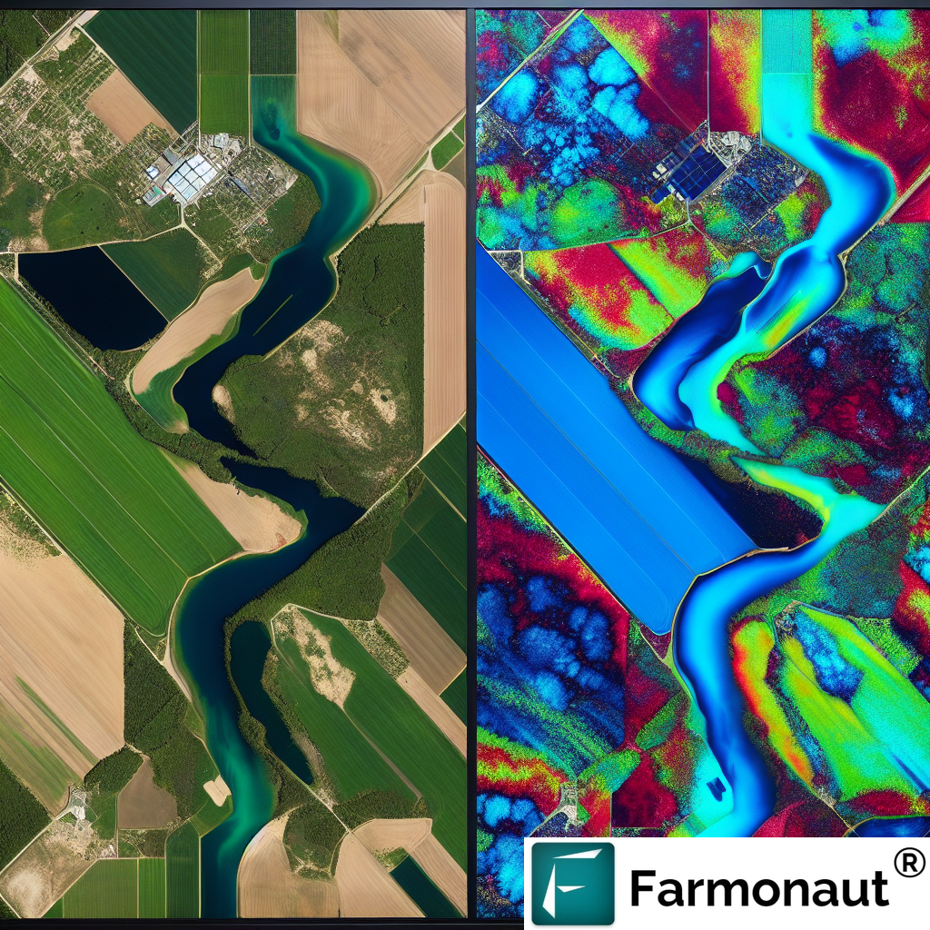
The MNDWI is an enhancement of the Normalized Difference Water Index (NDWI) and is particularly useful for distinguishing water bodies from land surfaces. For Sentinel-2 imagery, the MNDWI formula is:
MNDWI = (Green – SWIR) / (Green + SWIR)
Where:
- Green = Band 3 (560 nm)
- SWIR = Band 11 (1610 nm)
Applications of MNDWI in Agriculture
While the MNDWI is primarily used for water body detection, it has several applications in agriculture:
- Flood Monitoring: MNDWI can help identify flooded agricultural areas, allowing for rapid response and damage assessment.
- Irrigation Management: By detecting small water bodies and wet soil, MNDWI can assist in mapping irrigation patterns and efficiency.
- Wetland Delineation: For farms with wetland areas, MNDWI can help in mapping and monitoring these ecologically sensitive zones.
- Water Resource Management: MNDWI can aid in assessing water availability for agricultural use, especially in arid and semi-arid regions.
At Farmonaut, we integrate MNDWI analysis into our satellite-based crop monitoring system, providing farmers with valuable insights into water-related aspects of their fields. This information is crucial for optimizing irrigation strategies and managing water resources effectively.
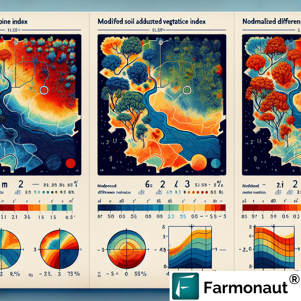
Modified Soil-Adjusted Vegetation Index (MSAVI)
MSAVI Formula
The MSAVI is an improvement over the Soil-Adjusted Vegetation Index (SAVI), designed to minimize soil background influences in areas with low vegetation cover. The MSAVI formula is:
MSAVI = (2 * NIR + 1 – sqrt((2 * NIR + 1)^2 – 8 * (NIR – Red))) / 2
Where:
- NIR = Near-Infrared band (Band 8 for Sentinel-2)
- Red = Red band (Band 4 for Sentinel-2)
Applications of MSAVI in Agriculture
MSAVI offers several advantages in agricultural applications:
- Early Crop Growth Monitoring: MSAVI is particularly useful in detecting vegetation in areas with sparse cover, making it ideal for monitoring early crop growth stages.
- Soil Erosion Assessment: By accurately distinguishing between soil and vegetation, MSAVI can help identify areas prone to soil erosion.
- Crop Yield Estimation: MSAVI’s sensitivity to vegetation changes makes it a valuable tool for estimating crop yields, especially in areas with variable soil conditions.
- Precision Agriculture: MSAVI can guide variable-rate applications of fertilizers and other inputs by providing accurate vegetation health information.
At Farmonaut, we utilize MSAVI in our crop health monitoring solutions, enabling farmers to make data-driven decisions about fertilizer application, irrigation, and other management practices. This index is particularly valuable in regions with challenging soil conditions or during the early stages of crop growth.
Normalized Difference Moisture Index (NDMI)
NDMI Formula
The NDMI is designed to assess vegetation water content and is particularly useful for monitoring drought conditions. The NDMI formula is:
NDMI = (NIR – SWIR) / (NIR + SWIR)
Where:
- NIR = Near-Infrared band (Band 8 for Sentinel-2)
- SWIR = Short-Wave Infrared band (Band 11 for Sentinel-2)
Applications of NDMI in Agriculture
NDMI has several important applications in agricultural monitoring:
- Drought Monitoring: NDMI is highly sensitive to changes in vegetation water content, making it an excellent indicator of drought stress.
- Irrigation Scheduling: By providing information on crop water status, NDMI can help optimize irrigation timing and amounts.
- Crop Health Assessment: Changes in NDMI can indicate various plant stresses, including disease and pest infestations that affect plant water content.
- Wildfire Risk Assessment: In agricultural areas prone to wildfires, NDMI can help assess vegetation dryness and potential fire risk.
Farmonaut incorporates NDMI analysis into our comprehensive crop monitoring platform, providing farmers with early warnings of water stress and enabling proactive management of irrigation resources. This index is particularly valuable in regions facing water scarcity or frequent drought conditions.
Integrating Vegetation Indices in Farmonaut’s Precision Agriculture Solutions
At Farmonaut, we understand the power of combining multiple vegetation indices to provide a comprehensive view of crop health and field conditions. Our advanced satellite-based monitoring system integrates MNDWI, MSAVI, NDMI, and other indices to offer farmers a holistic understanding of their crops and fields.
Here’s how we leverage these indices in our precision agriculture solutions:
- Comprehensive Crop Health Monitoring: By analyzing multiple indices, we provide farmers with a nuanced understanding of crop health, detecting issues related to water stress, nutrient deficiencies, and pest infestations early.
- Customized Advisory Services: Our AI-powered Jeevn advisory system uses these indices, along with other data sources, to generate personalized recommendations for crop management, irrigation, and input application.
- Historical Analysis and Trend Detection: We track these indices over time, allowing farmers to identify long-term trends in field conditions and crop performance.
- Integration with Weather Data: By combining vegetation index data with our satellite-based weather forecasting, we provide contextualized insights that account for both current crop status and upcoming weather conditions.
- Zone Management: Using MSAVI and other indices, we help farmers create management zones within their fields for precision application of inputs.
Our commitment to leveraging cutting-edge technology extends beyond just data collection. We’ve developed user-friendly interfaces that make this complex data accessible and actionable for farmers of all technical backgrounds. Whether you’re accessing our services through our web platform or mobile apps (available on Google Play and the App Store), you’ll find intuitive visualizations and clear recommendations based on these advanced vegetation indices.
The Farmonaut Advantage: Satellite vs. Drone and IoT Monitoring
While drone and IoT-based monitoring systems have their place in agriculture, Farmonaut’s satellite-based approach offers distinct advantages. Here’s a comparison table highlighting why our system is often the preferred choice for comprehensive farm monitoring:
| Feature | Farmonaut Satellite System | Drone-based Monitoring | IoT-based Monitoring |
|---|---|---|---|
| Coverage Area | Large scale (thousands of hectares) | Limited (tens to hundreds of hectares) | Very limited (point-based data) |
| Frequency of Data Collection | Regular (every few days, depending on satellite) | As needed, but requires manual operation | Continuous, but limited to sensor locations |
| Initial Setup Cost | Low (subscription-based) | High (equipment purchase) | Medium to High (sensors and network setup) |
| Operational Complexity | Low (fully automated) | High (requires trained operators) | Medium (maintenance of sensors required) |
| Data Processing | Automated with AI integration | Often requires manual processing | Automated but limited to sensor data |
| Weather Independence | High (can penetrate clouds with radar) | Low (affected by wind, rain) | High (but limited to sensor locations) |
| Scalability | Highly scalable across regions | Limited by equipment and personnel | Requires additional sensors for scaling |
As evident from the comparison, Farmonaut’s satellite-based system offers unparalleled coverage, cost-effectiveness, and ease of use, making it the ideal choice for farmers looking to implement precision agriculture practices at scale.
Leveraging Farmonaut’s API for Custom Applications
For developers and businesses looking to integrate our powerful satellite-based analytics into their own applications, we offer a robust API. Our Satellite API provides access to a wealth of data, including vegetation indices, weather forecasts, and historical trends.
Key features of our API include:
- Access to MNDWI, MSAVI, NDMI, and other vegetation indices for specified locations
- Historical data retrieval for trend analysis
- Weather forecast integration
- Customizable data outputs to suit various application needs
For detailed information on how to integrate our API into your applications, please refer to our comprehensive API documentation.
The Future of Precision Agriculture with Farmonaut
As we continue to innovate in the field of satellite-based agricultural monitoring, we’re excited about the future possibilities. Some areas we’re currently exploring include:
- Advanced Machine Learning Models: Developing more sophisticated AI models that can predict crop yields and detect plant diseases with even greater accuracy.
- Integration with IoT Devices: While our satellite system offers numerous advantages, we’re exploring ways to integrate data from ground-based IoT sensors for even more comprehensive monitoring.
- Expanded Crop-Specific Indices: Developing and implementing new vegetation indices tailored to specific crops and regions.
- Climate Change Adaptation Tools: Creating tools that help farmers adapt their practices to changing climate conditions, using long-term satellite data trends.
Our commitment is to continue providing farmers with the most advanced, yet accessible, tools for precision agriculture. By subscribing to Farmonaut, you’re not just getting access to current technology – you’re investing in a future where data-driven farming leads to increased productivity, sustainability, and profitability.
Subscribe to Farmonaut
Ready to revolutionize your farming practices with satellite-based precision agriculture? Subscribe to Farmonaut today and gain access to our comprehensive suite of tools, including advanced vegetation index analysis, AI-powered advisory services, and much more.
Frequently Asked Questions (FAQ)
Q: How often is satellite imagery updated in Farmonaut’s system?
A: The frequency of updates depends on the satellite constellation and your subscription level. Typically, we provide updates every 3-5 days, with options for more frequent monitoring in some regions.
Q: Can Farmonaut’s system work for small farms?
A: Absolutely! Our system is scalable and can provide valuable insights for farms of all sizes, from small holdings to large industrial operations.
Q: How accurate are the vegetation indices in detecting crop issues?
A: Our vegetation indices are highly accurate in detecting various crop issues. However, for best results, we recommend using them in conjunction with ground-truthing and our AI-powered advisory system.
Q: Is special training required to use Farmonaut’s platform?
A: While our platform is designed to be user-friendly, we provide comprehensive onboarding and ongoing support to ensure you can make the most of our tools. No specialized technical knowledge is required.
Q: Can Farmonaut’s system work in areas with frequent cloud cover?
A: Yes, we utilize a combination of optical and radar satellite data to provide consistent monitoring, even in areas with frequent cloud cover.
Q: How does Farmonaut ensure data privacy and security?
A: We take data privacy and security very seriously. All data is encrypted, and we adhere to strict data protection protocols. We never share individual farm data without explicit permission.
Conclusion
The MNDWI, MSAVI, and NDMI formulas, when applied to Sentinel-2 imagery, provide powerful tools for precision agriculture. At Farmonaut, we’re committed to making these advanced technologies accessible and actionable for farmers worldwide. By leveraging these indices and our comprehensive satellite-based monitoring system, we’re helping farmers optimize their operations, increase yields, and practice sustainable agriculture.
Ready to take your farming to the next level? Sign up for Farmonaut today and experience the future of precision agriculture.