Revolutionizing Farm Management: Farmonaut’s Advanced Satellite Imagery Analysis
At Farmonaut, we’re constantly pushing the boundaries of agricultural technology to empower farmers with cutting-edge solutions. We’re thrilled to announce our latest innovation that’s set to transform the way farmers interpret and utilize satellite imagery for better farm management. Our new feature combines data from seven different satellite images into a single, comprehensive view, enabling farmers to make faster, more informed decisions about their crops.
The Power of Consolidated Satellite Imagery
Our groundbreaking technology allows farmers to assess crucial data from multiple satellite images in one consolidated view. This advancement in remote sensing technology brings several benefits:
- Streamlined decision-making process
- Comprehensive overview of farm conditions
- Faster identification of problem areas
- More efficient resource allocation
Key Information at a Glance
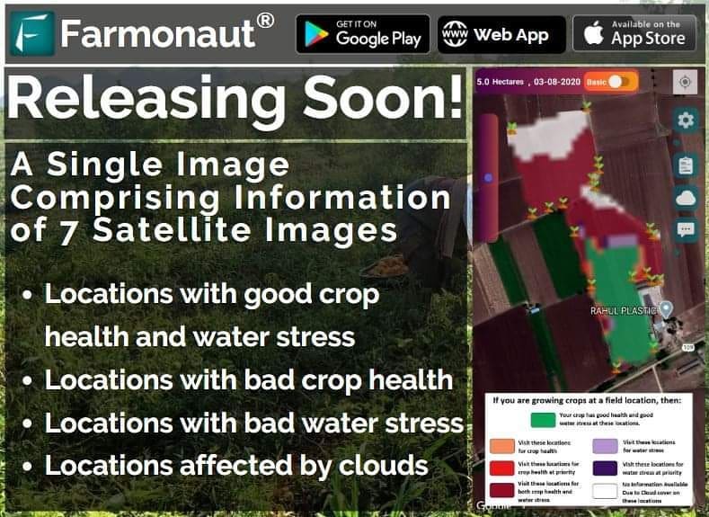
With this new image type, farmers can quickly identify:
- Locations with good crop health and optimal water stress levels
- Areas showing poor crop health
- Regions experiencing adverse water stress
- Sections affected by cloud covering
The Technology Behind the Innovation
Our new feature leverages advanced infrared satellite imagery and sophisticated algorithms to provide a comprehensive view of farm conditions. Here’s how it works:
1. Multi-spectral Imaging
We utilize various spectral bands to capture different aspects of crop and soil conditions:
- Near-infrared (NIR) for vegetation health assessment
- Short-wave infrared (SWIR) for moisture content analysis
- Visible light spectrum for true color representation
2. Data Integration
Our proprietary algorithms combine data from multiple satellite passes, ensuring a comprehensive and up-to-date view of the farm.
3. AI-Powered Analysis
Machine learning models interpret the integrated data, identifying patterns and anomalies that might be missed by the human eye.
4. User-Friendly Visualization
The complex data is translated into an easy-to-understand visual format, allowing farmers to quickly grasp the state of their fields.
Benefits of Farmonaut’s Advanced Satellite Imagery Analysis
Our new feature offers numerous advantages for modern farmers:
1. Time-Saving
By consolidating multiple images into one, we significantly reduce the time farmers spend analyzing different data sets.
2. Precision Agriculture
The detailed insights enable highly targeted interventions, optimizing resource use and improving crop yields.
3. Early Problem Detection
Rapid identification of issues related to crop health, water stress, or pest infestations allows for timely corrective actions.
4. Informed Decision Making
Comprehensive data empowers farmers to make evidence-based decisions about irrigation, fertilization, and pest control.
5. Sustainable Farming
By optimizing resource use, this technology supports more sustainable and environmentally friendly farming practices.
Understanding the Image Components
Let’s delve deeper into what each aspect of our consolidated image represents:
1. Good Crop Health and Water Stress
Areas displaying good crop health and optimal water stress levels are crucial indicators of overall farm performance. These regions typically show:
- Vibrant vegetation with high chlorophyll content
- Adequate but not excessive moisture levels
- Optimal plant growth and development
Identifying these areas helps farmers understand which parts of their fields are performing well and can serve as benchmarks for other sections.
2. Poor Crop Health
Regions exhibiting poor crop health require immediate attention. These areas might indicate:
- Nutrient deficiencies
- Pest or disease infestations
- Soil quality issues
Early detection of these problems allows farmers to implement targeted interventions, potentially saving crops and improving overall yield.
3. Adverse Water Stress
Water stress, both excess and deficiency, can significantly impact crop health. Our technology helps identify:
- Areas suffering from drought conditions
- Regions with poor drainage or waterlogging
- Sections with irrigation system failures
This information is crucial for optimizing irrigation strategies and improving water resource management.
4. Cloud-Affected Areas
While cloud covering can obstruct satellite imagery, our system intelligently identifies these areas, ensuring that farmers are aware of any data limitations. This transparency helps in:
- Understanding which parts of the field might need additional ground-level inspection
- Planning for future satellite passes to capture clear imagery of these areas
- Making informed decisions even with partial data
Practical Applications of Farmonaut’s Advanced Imagery
Our consolidated satellite imagery analysis opens up a world of possibilities for precision agriculture. Here are some practical ways farmers can leverage this technology:
1. Irrigation Management
By identifying areas with different water stress levels, farmers can:
- Adjust irrigation schedules for specific field sections
- Detect and repair leaks in irrigation systems
- Implement targeted deficit irrigation strategies for water conservation
2. Fertilizer Application
Crop health information allows for precision in nutrient management:
- Apply fertilizers only where needed, reducing waste and environmental impact
- Adjust fertilizer formulations based on specific crop health issues
- Monitor the effectiveness of fertilizer applications over time
3. Pest and Disease Control
Early detection of poor crop health can indicate pest or disease problems:
- Implement targeted pest control measures
- Minimize pesticide use by treating only affected areas
- Monitor the spread of diseases and the effectiveness of treatments
4. Yield Prediction and Harvest Planning
Comprehensive field data aids in accurate yield forecasting:
- Estimate yields based on crop health across different field sections
- Plan harvest logistics more effectively
- Make informed decisions about crop storage and marketing
5. Long-term Farm Planning
Historical data from our system supports strategic decision-making:
- Identify consistently underperforming areas for soil remediation or crop rotation
- Plan infrastructure improvements like drainage systems
- Optimize field layouts for future planting seasons
Farmonaut’s Satellite System vs. Drone and IoT-based Monitoring
While drones and IoT devices offer valuable insights for farm management, Farmonaut’s satellite-based system provides unique advantages. Here’s a comparison:
| Feature | Farmonaut Satellite System | Drone-based Monitoring | IoT-based Monitoring |
|---|---|---|---|
| Coverage Area | Large scale (hundreds to thousands of hectares) | Limited (typically under 100 hectares per flight) | Localized (depends on sensor placement) |
| Frequency of Data Collection | Regular (every few days, depending on satellite pass) | On-demand (requires manual flight operations) | Continuous (real-time data possible) |
| Initial Setup Cost | Low (no hardware required) | High (drone and camera equipment needed) | Moderate to High (sensors and network infrastructure required) |
| Operational Complexity | Low (automated data collection and analysis) | High (requires trained operators and flight planning) | Moderate (requires maintenance of sensors and network) |
| Weather Dependency | Moderate (affected by heavy cloud cover) | High (cannot operate in poor weather conditions) | Low (most sensors operate in all weather conditions) |
| Data Integration Capability | High (combines multiple data sources) | Moderate (limited to visual and multispectral imaging) | High (can integrate various types of sensors) |
| Scalability | Highly scalable (can monitor multiple farms easily) | Limited scalability (requires additional equipment and personnel) | Moderately scalable (requires additional hardware for expansion) |
Getting Started with Farmonaut
Ready to revolutionize your farm management with our advanced satellite imagery analysis? Here’s how you can get started:
- Visit our website at https://farmonaut.com/app_redirect to sign up for an account.
- Download our mobile app:
- For Android: Farmonaut on Google Play
- For iOS: Farmonaut on the App Store
- Explore our API documentation at Farmonaut API Docs for custom integrations.
Subscribe to Farmonaut
Experience the power of our advanced satellite imagery analysis by subscribing to Farmonaut today:
Frequently Asked Questions (FAQ)
Q: How often are satellite images updated?
A: The frequency of updates depends on satellite passes and weather conditions. Typically, we provide new imagery every 3-5 days, but this can vary based on your location and subscription level.
Q: Can Farmonaut’s system work for small farms?
A: Absolutely! Our system is designed to be scalable and can provide valuable insights for farms of all sizes, from small holdings to large agricultural operations.
Q: How accurate is the crop health assessment?
A: Our crop health assessments are highly accurate, thanks to our advanced algorithms and multi-spectral imaging. However, we always recommend combining our insights with on-ground observations for the best results.
Q: What types of crops can be monitored using Farmonaut?
A: Our system is versatile and can monitor a wide range of crops, including grains, fruits, vegetables, and cash crops. The effectiveness may vary slightly depending on the crop type and growth stage.
Q: How does cloud cover affect the imagery?
A: While heavy cloud cover can obstruct satellite imagery, our system is designed to identify cloud-affected areas. We use multiple satellite passes and advanced algorithms to minimize the impact of cloud cover on our analysis.
Q: Can Farmonaut’s system detect specific diseases or pests?
A: While our system can identify areas of poor crop health that may indicate disease or pest problems, it cannot diagnose specific issues. It’s a powerful tool for early detection, allowing farmers to investigate and diagnose problems on the ground.
Q: Is internet connectivity required to use Farmonaut?
A: Internet connectivity is required to receive updated satellite imagery and analysis. However, once data is downloaded to your device, you can view it offline in our mobile app.
Q: How does Farmonaut ensure data privacy and security?
A: We take data privacy and security very seriously. All data is encrypted during transmission and storage, and we adhere to strict privacy policies to ensure your farm data remains confidential.
Q: Can I integrate Farmonaut’s data with other farm management software?
A: Yes, we offer API access that allows for integration with other farm management tools. Check our API documentation for more details.
Q: What support does Farmonaut offer if I need help interpreting the data?
A: We provide comprehensive support, including user guides, video tutorials, and a dedicated customer support team to help you make the most of our satellite imagery analysis.
Conclusion: Empowering Farmers with Advanced Technology
At Farmonaut, we’re committed to revolutionizing agriculture through innovative technology. Our new consolidated satellite imagery analysis is a significant step forward in making precision agriculture more accessible and effective for farmers worldwide. By providing comprehensive, easy-to-interpret data on crop health, water stress, and field conditions, we’re empowering farmers to make better decisions, optimize resource use, and ultimately improve their yields and profitability.
As we continue to innovate and refine our technology, we remain focused on our mission: to make advanced agricultural solutions accessible to farmers of all scales. We believe that by combining the power of satellite technology, artificial intelligence, and agronomic expertise, we can contribute to a more sustainable and productive future for agriculture.
Stay tuned for the official release of this groundbreaking feature, and get ready to take your farm management to the next level with Farmonaut. Together, we’re cultivating a smarter, more efficient future for farming.
Happy Farming!
