Revolutionizing Agriculture: Farmonaut’s Satellite-Based Crop Health Monitoring System
In the ever-evolving landscape of agriculture, we at Farmonaut are proud to be at the forefront of innovation, bringing cutting-edge satellite technology and remote sensing capabilities to farmers across the globe. Our mission is clear: to democratize access to advanced agricultural technologies and empower farmers with the tools they need to thrive in the 21st century.
The Power of Satellite-Based Crop Health Monitoring
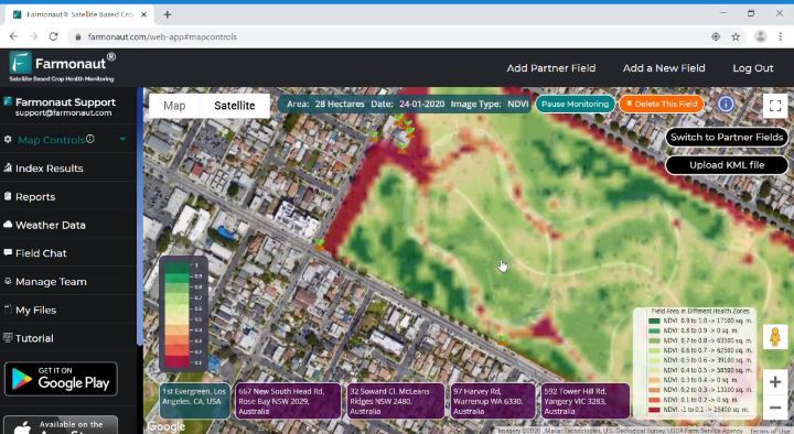
At the heart of our offering lies Farmonaut’s Satellite-Based Crop Health Monitoring System, a revolutionary platform designed to put the power of satellites into the hands of every farmer, regardless of the size of their operation. We believe that by breaking down cost barriers and simplifying access to sophisticated remote sensing technologies, we can usher in a new era of smart farming that benefits farmers, consumers, and the planet alike.
Key Features of Our System:
- Real-time crop health analysis
- Vegetation index monitoring (NDVI)
- Soil moisture assessment
- Weather forecasting and historical data
- AI-powered insights and recommendations
Our system is not just a tool; it’s a comprehensive solution that brings the benefits of precision agriculture to farmers everywhere. By leveraging the power of satellites, we provide an always-ready platform for field monitoring that doesn’t require expensive on-ground sensors or time-consuming manual inspections.
Expanding Access: Web and Mobile Applications
In our ongoing effort to make our technology as accessible as possible, we’ve expanded our platform to include both web and mobile applications. This multi-platform approach ensures that farmers can access critical information about their fields anytime, anywhere.
Web Application
Our web application offers a robust interface for detailed analysis and planning. Farmers can access comprehensive reports, historical data, and advanced analytics tools from their desktop or laptop computers. To explore our web application, visit Farmonaut Web Platform.
Mobile Applications
For on-the-go access, our mobile applications for Android and iOS devices put the power of satellite monitoring in farmers’ pockets. These apps are designed for ease of use, allowing quick field checks and instant notifications about crop health issues.
- Download our Android app: Farmonaut on Google Play
- Download our iOS app: Farmonaut on the App Store
The Farmonaut Advantage: Satellite vs. Drone and IoT Monitoring
While drones and IoT devices have their place in modern agriculture, satellite-based monitoring offers unique advantages that make it an indispensable tool for farmers of all scales. Here’s how Farmonaut’s Satellite System compares to other monitoring methods:
| Feature | Farmonaut Satellite System | Drone-based Monitoring | IoT-based Monitoring |
|---|---|---|---|
| Coverage Area | Large scale (hundreds to thousands of acres) | Limited (typically under 100 acres per flight) | Limited by sensor placement |
| Frequency of Updates | Regular (every few days, depending on satellite pass) | As needed, but requires manual operation | Continuous, but limited to sensor locations |
| Initial Investment | Low (subscription-based) | High (equipment purchase + training) | Moderate to High (sensor network setup) |
| Operational Costs | Low | Moderate (maintenance, pilot fees) | Low to Moderate (sensor maintenance) |
| Ease of Use | High (accessible via web and mobile apps) | Moderate (requires skilled operator) | Moderate (requires technical setup) |
| Weather Dependency | Low (can penetrate clouds) | High (limited by wind and precipitation) | Low (but sensors can be damaged by extreme weather) |
| Data Analysis | Advanced (AI-powered insights) | Varies (depends on post-processing) | Real-time, but limited to sensor capabilities |
The Technology Behind Farmonaut
At Farmonaut, we harness the power of cutting-edge technologies to deliver unparalleled insights to farmers. Our Satellite-Based Crop Health Monitoring System is built on a foundation of advanced remote sensing techniques, artificial intelligence, and robust data analytics.
Satellite Imagery and Multispectral Analysis
We utilize high-resolution satellite imagery that captures data across multiple spectral bands. This multispectral approach allows us to analyze various aspects of crop health and field conditions:
- Normalized Difference Vegetation Index (NDVI): This index helps us assess plant health and vigor by measuring the difference between near-infrared light (which healthy plants reflect) and red light (which they absorb).
- Soil Moisture Index: By analyzing specific spectral bands, we can estimate soil moisture levels, helping farmers optimize irrigation practices.
- Crop Stress Detection: Our system can identify areas of potential crop stress before they become visible to the naked eye, allowing for early intervention.
Artificial Intelligence and Machine Learning
To transform raw satellite data into actionable insights, we employ sophisticated AI and machine learning algorithms. These technologies enable us to:
- Automatically detect and classify crop types
- Predict potential yield based on historical data and current conditions
- Identify patterns that may indicate pest infestations or disease outbreaks
- Generate personalized recommendations for crop management
Weather Integration and Forecasting
Understanding that weather plays a crucial role in agriculture, we’ve integrated advanced weather forecasting capabilities into our platform. This allows farmers to:
- Access hyperlocal weather forecasts for their specific fields
- Receive alerts for extreme weather events
- Plan farming activities based on predicted weather patterns
The Impact of Satellite-Based Monitoring on Agriculture
The adoption of satellite technology in agriculture is more than just a technological upgrade; it’s a paradigm shift in how we approach farming. Here are some of the ways Farmonaut’s system is transforming agriculture:
1. Increased Crop Yields
By providing timely and accurate information about crop health, our system enables farmers to address issues promptly, leading to significant improvements in crop yields. Early detection of stress factors allows for targeted interventions, minimizing crop losses and maximizing productivity.
2. Resource Optimization
With precise data on soil moisture levels and crop health, farmers can optimize their use of water, fertilizers, and pesticides. This not only reduces costs but also minimizes the environmental impact of farming practices, promoting sustainability in agriculture.
3. Risk Mitigation
Our system’s ability to detect early signs of crop stress, pest infestations, or disease outbreaks helps farmers mitigate risks effectively. By addressing issues before they escalate, farmers can protect their investments and ensure more stable crop production.
4. Time and Labor Savings
Traditional field scouting is time-consuming and labor-intensive. Satellite-based monitoring dramatically reduces the need for manual inspections, allowing farmers to allocate their time and resources more efficiently.
5. Data-Driven Decision Making
By providing comprehensive, data-driven insights, our system empowers farmers to make informed decisions about every aspect of their operations. This leads to more efficient farming practices and better long-term planning.
Case Studies: Farmonaut in Action
To illustrate the real-world impact of our Satellite-Based Crop Health Monitoring System, let’s look at a few case studies from farmers who have implemented our technology:
Case Study 1: Medium-Scale Organic Vegetable Farm
An organic vegetable farmer in Indiana with 300 acres of diverse crops adopted Farmonaut to improve their sustainable farming practices. The results included:
- More efficient water usage through precise irrigation scheduling, reducing water consumption by 20%
- Early detection of fungal disease in tomato crops, preventing spread and minimizing crop loss
- Improved crop rotation planning based on detailed field health history
- A 12% increase in marketable produce due to better overall crop health management
The Future of Farming with Farmonaut
As we continue to innovate and expand our services, we envision a future where satellite technology and remote sensing are integral parts of every farming operation, regardless of size or location. Our ongoing development efforts focus on:
1. Enhanced AI Capabilities
We’re continually refining our AI algorithms to provide even more accurate predictions and personalized recommendations. Future updates will include advanced crop yield forecasting and automated pest and disease identification.
2. Integration with IoT Devices
While our satellite-based system offers comprehensive coverage, we recognize the value of ground-level data. We’re working on integrating our platform with IoT devices to provide farmers with a holistic view of their fields, combining satellite imagery with on-the-ground sensor data.
3. Blockchain-Based Traceability
To support the growing demand for transparency in the food supply chain, we’re developing blockchain-based traceability solutions that will allow consumers to trace their food from farm to table, leveraging our satellite monitoring data to verify sustainable farming practices.
4. Climate Change Adaptation Tools
As climate change continues to impact agriculture, we’re developing tools to help farmers adapt. This includes long-term climate trend analysis and recommendations for climate-resilient farming practices tailored to specific regions.
Join the Farmonaut Revolution
We invite farmers, agronomists, and agricultural businesses of all sizes to join us in revolutionizing agriculture through satellite technology and remote sensing. By subscribing to Farmonaut’s Satellite-Based Crop Health Monitoring System, you’re not just gaining access to cutting-edge technology – you’re joining a community of forward-thinking farmers committed to sustainable, efficient, and productive agriculture.
API Access for Developers
For developers and businesses looking to integrate Farmonaut’s powerful satellite and weather data into their own applications, we offer comprehensive API access. Our API allows you to leverage our advanced remote sensing capabilities and incorporate them into your own agritech solutions.
To learn more about our API offerings and access our developer documentation, visit: Farmonaut API Documentation
Frequently Asked Questions (FAQ)
Q: How often is satellite data updated in Farmonaut’s system?
A: Our satellite data is typically updated every 3-5 days, depending on satellite passes and weather conditions. This frequency ensures that farmers have access to recent information about their fields while balancing the need for detailed analysis.
Q: Can Farmonaut’s system work for small farms?
A: Absolutely! Our system is designed to be scalable and accessible for farms of all sizes. Whether you’re managing a few acres or thousands, Farmonaut can provide valuable insights to improve your farming practices.
Q: How accurate is the weather forecasting feature?
A: Our weather forecasting feature combines data from multiple sources and uses advanced modeling techniques to provide highly accurate, localized forecasts. While no forecast is 100% accurate, our system typically achieves over 90% accuracy for short-term predictions.
Q: Is an internet connection required to use Farmonaut?
A: An internet connection is required to receive updates and access the full features of our web and mobile applications. However, some basic information and previously downloaded data can be accessed offline in our mobile apps.
Q: Can Farmonaut detect specific crop diseases?
A: While our system can detect general signs of crop stress that may indicate disease, it cannot diagnose specific diseases solely through satellite imagery. However, our AI-powered insights can alert farmers to potential issues, prompting closer inspection and early intervention.
Q: Is my farm data secure with Farmonaut?
A: Yes, we take data security very seriously. All farm data is encrypted and stored securely in compliance with international data protection standards. We never share individual farm data without explicit permission from the farmer.
Q: Can I use Farmonaut for crop insurance claims?
A: Many insurance providers accept data from satellite-based monitoring systems like Farmonaut as supporting evidence for crop insurance claims. However, it’s best to check with your specific insurance provider about their policies regarding satellite data.
Q: Does Farmonaut work for all crop types?
A: Farmonaut’s system is designed to work with a wide variety of crop types, including grains, fruits, vegetables, and cash crops. However, the level of detail and specific insights may vary depending on the crop type and growing conditions.
Q: How does Farmonaut compare to drone-based monitoring?
A: While drones can provide very high-resolution imagery, they are limited in terms of coverage area and frequency of monitoring. Farmonaut’s satellite-based system offers consistent, large-scale coverage without the need for on-site equipment or operators.
Q: Can Farmonaut help with precision agriculture practices?
A: Absolutely! Our system is designed to support precision agriculture by providing detailed, field-specific data that can be used to optimize various farming practices, including variable rate application of inputs and targeted irrigation.
By embracing satellite technology and remote sensing through Farmonaut’s Crop Health Monitoring System, farmers are equipping themselves with the tools needed to thrive in the modern agricultural landscape. Our commitment to innovation, accessibility, and sustainability drives us to continually improve and expand our offerings, ensuring that farmers around the world have access to the best agritech solutions available.
Join us in shaping the future of agriculture. Together, we can create a more efficient, productive, and sustainable farming industry that benefits farmers, consumers, and the planet alike.
