Here’s a comprehensive blog post based on your requirements:
Revolutionizing Agriculture: The Power of Precision Farming with Satellite Imagery
In the ever-evolving landscape of modern agriculture, technology is playing an increasingly pivotal role in elevating farming practices to unprecedented levels. At the forefront of this agricultural revolution is precision farming, a concept that has been transforming the way we approach crop management and yield optimization. At Farmonaut, we’re proud to be at the cutting edge of this transformation, offering advanced solutions that harness the power of satellite imagery to provide farmers and agribusinesses with the tools they need to make informed decisions and maximize their productivity.
The Rise of Precision Agriculture
Precision agriculture, powered by cutting-edge technology, is revolutionizing the farming industry. By utilizing advanced tools and techniques, farmers can now make data-driven decisions that optimize crop yields, reduce waste, and minimize environmental impact. One of the most powerful tools in the precision farming arsenal is satellite imagery, which provides a bird’s-eye view of agricultural lands and offers invaluable insights into crop health, soil conditions, and productivity potential.
Farmonaut: Pioneering Satellite-Based Farm Management Solutions
At Farmonaut, we’re committed to making precision agriculture accessible and affordable for farmers worldwide. Our platform integrates innovative technology with data-driven insights to enhance traditional farming practices. We offer a range of services designed to help farmers and agribusinesses optimize their operations:
- Real-time crop health monitoring
- AI-based advisory systems
- Blockchain-based traceability
- Resource management tools
The Power of Satellite Imagery in Agriculture
Satellite imagery has emerged as a game-changer in the agricultural sector. By providing a comprehensive view of vast agricultural areas, it enables farmers to monitor their crops with unprecedented accuracy and efficiency. Here’s how satellite imagery is transforming farming practices:
1. Crop Health Monitoring
Our soil and crop health monitoring system utilizes multispectral satellite images to assess vegetation health through the Normalized Difference Vegetation Index (NDVI). This allows farmers to identify areas of stress or disease in their crops before they become visible to the naked eye, enabling early intervention and potentially saving entire harvests.
2. Soil Moisture Analysis
Satellite data can provide insights into soil moisture levels across large areas, helping farmers optimize irrigation schedules and prevent water waste. This is particularly crucial in regions facing water scarcity or drought conditions.
3. Yield Prediction
By analyzing historical satellite data and current crop conditions, our crop yield calculator can provide accurate yield predictions. This information is invaluable for farmers and agribusinesses in planning harvests, managing resources, and making informed financial decisions.
4. Resource Optimization
Satellite imagery allows for precise mapping of field variability, enabling farmers to apply fertilizers, pesticides, and water more efficiently. This targeted approach not only reduces costs but also minimizes environmental impact.
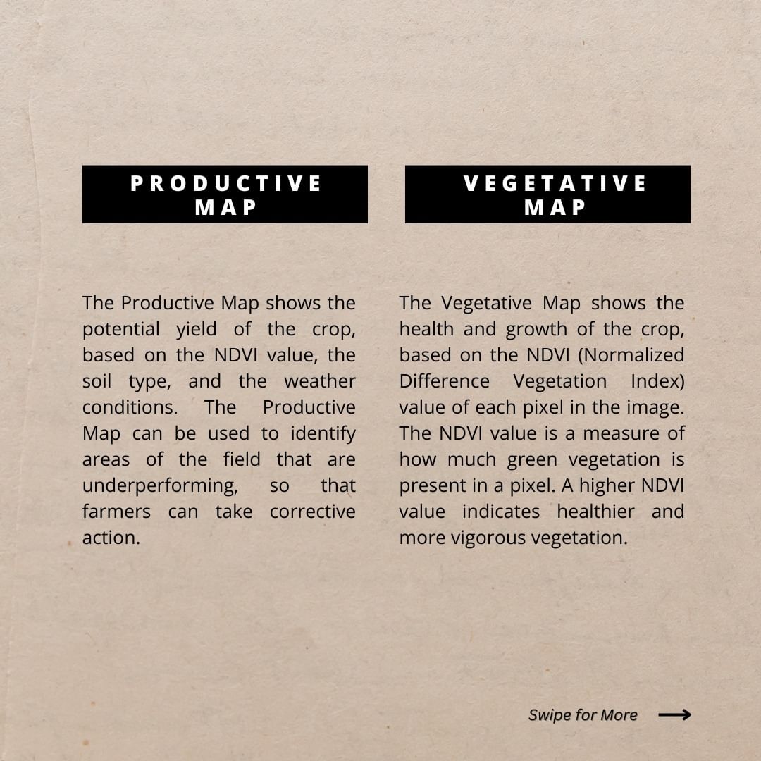
Vegetative Maps vs. Productive Maps: Understanding the Difference
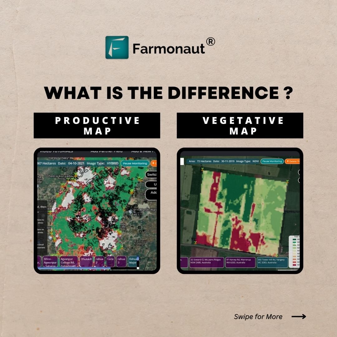
At Farmonaut, we provide two essential tools for precision agriculture: Vegetative Maps and Productive Maps. While both utilize satellite imagery, they offer different insights that are crucial for comprehensive farm management.
Vegetative Maps: The Crop Health Report Card
Vegetative Maps focus on assessing the health and vigor of crops. They provide real-time insights into plant growth, stress levels, and overall well-being. Here’s what you need to know about Vegetative Maps:
- Based on NDVI (Normalized Difference Vegetation Index) values
- Indicates crop health and growth
- Used for identifying areas that need immediate attention
- Provides short-term insights for quick decision-making
Productive Maps: Unlocking Yield Potential
Productive Maps, on the other hand, offer a broader perspective on field productivity. They help farmers identify varying productivity zones within their fields, guiding strategic decisions for optimizing yield. Key features of Productive Maps include:
- Based on NDVI values, soil type, and weather conditions
- Measures crop yield potential
- Used for planning crop planting and harvesting strategies
- Provides long-term insights for strategic planning
The Farmonaut Advantage: Why Choose Satellite-Based Monitoring?
While there are various technologies available for farm monitoring, including drones and IoT devices, satellite-based systems offer unique advantages. Here’s how Farmonaut’s satellite system compares to other monitoring methods:
| Feature | Farmonaut Satellite System | Drone-based Monitoring | IoT-based Monitoring |
|---|---|---|---|
| Coverage Area | Large-scale (Unlimited) | Limited by flight time and regulations | Limited by sensor placement |
| Frequency of Data Collection | Regular (Every few days) | On-demand (Requires manual flights) | Continuous |
| Initial Investment | Low | High (Equipment costs) | Medium to High (Sensor costs) |
| Operational Costs | Low | Medium (Maintenance, pilot fees) | Low to Medium (Maintenance, data plans) |
| Ease of Use | High (No equipment needed) | Medium (Requires trained operators) | Medium (Requires setup and maintenance) |
| Data Processing | Automated | Often requires manual processing | Automated |
| Weather Dependency | Low (Can penetrate clouds) | High (Cannot fly in bad weather) | Low |
Farmonaut’s Cutting-Edge Technologies
Our commitment to innovation drives us to continually enhance our offerings. Here are some of the advanced technologies we employ to provide unparalleled farm management solutions:
1. IR Satellite Imagery
We utilize infrared (IR) satellite imagery to gather detailed information about crop health and soil conditions. IR imagery can reveal details invisible to the naked eye, providing insights into plant stress, disease, and nutrient deficiencies.
2. AI-Powered Jeevn AI Advisory System
Our Jeevn AI system analyzes satellite data and other inputs to generate personalized farm advice. This AI-driven tool provides real-time insights, weather forecasts, and expert crop management strategies tailored to each farm’s unique conditions.
3. Blockchain-Based Traceability
We’ve integrated blockchain technology to ensure transparency and security in agricultural supply chains. This feature is particularly valuable for industries requiring product traceability from farm to consumer.
4. Advanced Crop Monitoring System
Our comprehensive crop monitoring system combines satellite imagery with machine learning algorithms to provide real-time updates on crop health, growth stages, and potential issues. This system enables proactive management and timely interventions.
5. Carbon Footprint Tracking
To support sustainable farming practices, we offer carbon footprint tracking. This feature helps agribusinesses monitor and reduce their environmental impact, aligning with global sustainability goals.
Upgrading Agriculture with Farmonaut’s Web App
Our user-friendly web application is designed to put the power of precision agriculture at your fingertips. The upgrade agriculture technology web app offers:
- Intuitive interface for easy navigation
- Real-time satellite imagery and analysis
- Customizable alerts and notifications
- Integration with other farm management tools
- Mobile accessibility for on-the-go monitoring
Experience the future of farming by visiting our web app: Farmonaut Web App
Empowering Developers: Farmonaut API
For developers and businesses looking to integrate our powerful satellite and weather data into their own systems, we offer a robust API. Our API provides access to:
- Real-time satellite imagery
- Weather forecasts and historical data
- Crop health indices
- Soil moisture data
Explore the possibilities with our API: Farmonaut API
For detailed documentation on how to use our API, visit: Farmonaut API Documentation
Mobile Access: Farmonaut on the Go
To ensure you have access to critical farm data wherever you are, we’ve developed mobile applications for both Android and iOS platforms:
- Android users can download our app from the Google Play Store: Farmonaut for Android
- iOS users can find our app on the App Store: Farmonaut for iOS
The Future of Farming with Farmonaut
As we continue to innovate and expand our services, we remain committed to our mission of making precision agriculture accessible to farmers worldwide. By leveraging the power of satellite technology, AI, and data analytics, we’re helping to create a more sustainable and productive agricultural future.
Join the Precision Agriculture Revolution
Ready to take your farming practices to the next level? Subscribe to Farmonaut today and unlock the full potential of your agricultural operations:
Frequently Asked Questions (FAQ)
Q: What is precision agriculture?
A: Precision agriculture is an approach to farm management that uses information technology and specialized equipment to optimize crop yields and reduce waste. It involves collecting and analyzing data about variability in fields to guide more efficient use of resources like water, fertilizers, and pesticides.
Q: How does satellite imagery benefit farmers?
A: Satellite imagery provides farmers with a comprehensive view of their fields, offering insights into crop health, soil moisture, and productivity variations. This information helps in making informed decisions about irrigation, fertilization, and pest control, ultimately leading to improved yields and reduced costs.
Q: What’s the difference between a Vegetative Map and a Productive Map?
A: A Vegetative Map focuses on current crop health and growth, using NDVI values to show areas that need immediate attention. A Productive Map, on the other hand, indicates potential yield based on NDVI values, soil type, and weather conditions, helping with long-term planning and strategy.
Q: How often is the satellite data updated?
A: The frequency of satellite data updates can vary depending on the specific service and satellite constellation used. At Farmonaut, we typically provide updates every few days, ensuring you have access to recent and relevant data for your decision-making.
Q: Is Farmonaut suitable for small-scale farmers?
A: Absolutely! Farmonaut is designed to be accessible and affordable for farmers of all scales. Our solutions can be tailored to meet the needs of small-scale farmers, helping them benefit from precision agriculture technologies without significant upfront investments.
Q: How accurate are the yield predictions provided by Farmonaut?
A: Our yield predictions are based on advanced algorithms that consider multiple factors including historical data, current crop health, weather conditions, and soil characteristics. While no prediction is 100% accurate, our system provides highly reliable estimates that have helped numerous farmers plan their harvests effectively.
Q: Can Farmonaut’s system detect crop diseases?
A: Yes, our system can detect signs of crop stress and potential disease outbreaks. By analyzing changes in vegetation indices and comparing them with known patterns of disease progression, we can alert farmers to potential issues before they become severe.
Q: How does Farmonaut support sustainable farming practices?
A: Farmonaut promotes sustainability in several ways:
- Optimizing resource use (water, fertilizers, pesticides) to reduce waste and environmental impact
- Providing carbon footprint tracking to help farms reduce their emissions
- Enabling precision agriculture practices that improve soil health and biodiversity
- Supporting informed decision-making that leads to more sustainable farming practices
Q: Is internet connectivity required to use Farmonaut?
A: Internet connectivity is required to access real-time data and updates through our web and mobile applications. However, we understand that connectivity can be an issue in some rural areas. Our system allows for data to be downloaded when connected, enabling offline viewing of recent reports and maps.
Q: How does Farmonaut ensure data security and privacy?
A: At Farmonaut, we take data security and privacy very seriously. We employ industry-standard encryption methods to protect data transmission and storage. Our blockchain-based systems add an extra layer of security for traceability features. Additionally, we adhere to strict privacy policies and only use farm data for the purposes specified in our user agreements.
By leveraging the power of satellite technology and data analytics, Farmonaut is at the forefront of the agricultural revolution. We’re committed to empowering farmers with the tools and insights they need to thrive in an increasingly complex and challenging environment. Join us in shaping the future of agriculture – where precision, sustainability, and productivity go hand in hand.
For more information and updates, follow us on social media:
- Instagram: @farmonaut
- YouTube: Farmonaut Channel
Visit our website: www.farmonaut.com
Contact us: +91 6366026267 | [email protected]
