Here’s a comprehensive blog post based on your requirements:
Revolutionizing Agriculture: Farmonaut Introduces New Satellite Data for Enhanced Crop Health Monitoring
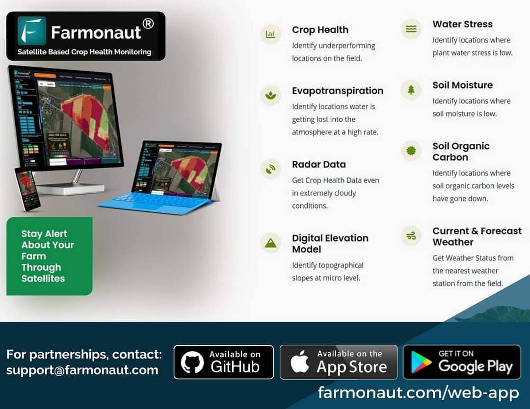
At Farmonaut, we’re constantly pushing the boundaries of agricultural technology to provide farmers with the most advanced and effective tools for crop management. Today, we’re thrilled to announce a significant upgrade to our satellite-based crop health monitoring system. We’re introducing two new types of satellite data that will further enhance our already robust offerings: Moisture Images (NDMI) and Digital Elevation Model (DEM) Data.
Expanding Our Satellite-Based Crop Health Monitoring Capabilities
As pioneers in the field of precision agriculture, we at Farmonaut understand the critical role that accurate, timely data plays in modern farming. Our satellite-based crop health monitoring system has already revolutionized how farmers approach field management, resource allocation, and decision-making. Now, with the addition of NDMI and DEM data, we’re taking our services to new heights.
Understanding NDMI (Normalized Difference Moisture Index)
The Normalized Difference Moisture Index (NDMI) is a powerful tool for assessing vegetation water content. Here’s what you need to know about this innovative technology:
- What is NDMI? NDMI is an index that uses near-infrared (NIR) and short-wave infrared (SWIR) bands to display moisture content in vegetation.
- How does it work? The SWIR band reflects changes in both vegetation water content and the spongy mesophyll structure in vegetation canopies. Meanwhile, NIR reflectance is affected by leaf internal structure and leaf dry matter content, but not by water content.
- Why is it useful? By combining NIR and SWIR data, we can eliminate variations caused by leaf internal structure and dry matter content, resulting in a more accurate assessment of vegetation water content.
Introducing Digital Elevation Model (DEM) Data
In addition to NDMI, we’re excited to offer Digital Elevation Model (DEM) data to our users. This new feature provides invaluable insights into field topography:
- What is a DEM? A Digital Elevation Model is a 3D representation of the Earth’s bare ground surface, excluding trees, buildings, and other surface objects.
- Why is it important for agriculture? Understanding field topography is crucial for effective water management, erosion control, and precision farming practices.
- How can farmers use DEM data? With this information, farmers can optimize irrigation systems, plan contour plowing, and make informed decisions about crop placement based on elevation and slope.
The Power of NIR and SWIR Bands in Agriculture
To fully appreciate the significance of our new NDMI offerings, it’s essential to understand the role of NIR and SWIR bands in satellite imagery:
Near-Infrared (NIR) Band
- NIR is particularly sensitive to leaf structure and plant health.
- Healthy vegetation strongly reflects NIR light, making it an excellent indicator of plant vigor.
- NIR data helps in assessing biomass, leaf area index, and overall crop health.
Short-Wave Infrared (SWIR) Band
- SWIR is highly sensitive to moisture content in soil and vegetation.
- It can penetrate thin cloud cover, making it useful even in partially cloudy conditions.
- SWIR data is invaluable for detecting water stress in crops and assessing soil moisture levels.
By combining these two powerful spectral bands, our NDMI images provide farmers with unparalleled insights into crop moisture status, enabling more precise irrigation management and early detection of water stress.
How Farmonaut’s Satellite System Compares to Drone and IoT-Based Farm Monitoring
While drones and IoT sensors have their place in modern agriculture, Farmonaut’s satellite-based system offers distinct advantages. Here’s a comparison:
| Feature | Farmonaut Satellite System | Drone-Based Monitoring | IoT-Based Monitoring |
|---|---|---|---|
| Coverage Area | Large scale (100s to 1000s of hectares) | Limited (typically 10-100 hectares per flight) | Limited to sensor placement |
| Frequency of Data Collection | Regular (every few days, depending on satellite revisit time) | As needed, but requires manual flights | Continuous, real-time |
| Initial Setup Cost | Low (subscription-based) | High (equipment purchase) | Medium to High (sensor network installation) |
| Operational Complexity | Low (automated data collection and processing) | High (requires trained pilots and manual data processing) | Medium (requires maintenance of sensor network) |
| Weather Dependency | Low (can use radar data in cloudy conditions) | High (cannot fly in poor weather) | Low (operates in most weather conditions) |
| Data Types Available | Multispectral, Thermal, Radar, DEM | Multispectral, Thermal | Point-based measurements (e.g., soil moisture, temperature) |
As you can see, our satellite-based system offers a unique combination of broad coverage, regular data updates, and diverse data types, all with minimal operational complexity and initial investment.
Accessing and Using the New Data on Farmonaut Platform
We’re committed to making our advanced technologies accessible to all our users. Here’s how you can start benefiting from our new NDMI and DEM data:
For Web and Smartphone Users
- Log in to your Farmonaut account at https://farmonaut.com/app_redirect
- Navigate to your field of interest
- Look for the new NDMI and DEM layers in the data visualization options
- Toggle these layers on to view the new data overlaid on your field map
For API Users
- Access our updated API documentation at https://farmonaut.com/farmonaut-satellite-weather-api-developer-docs/
- Implement the new endpoints for NDMI and DEM data retrieval
- Integrate these new data types into your custom applications or analysis workflows
For detailed instructions on using our API, please visit https://sat.farmonaut.com/api.
Practical Applications of NDMI and DEM Data in Agriculture
The addition of NDMI and DEM data to our platform opens up new possibilities for precision agriculture. Here are some ways farmers can leverage this information:
NDMI Applications
- Irrigation Management: Use NDMI data to identify areas of water stress and optimize irrigation schedules.
- Drought Monitoring: Track NDMI values over time to detect and respond to drought conditions early.
- Crop Health Assessment: Combine NDMI with other indices for a comprehensive view of crop vigor and stress.
- Yield Prediction: Use historical NDMI data to develop more accurate yield prediction models.
DEM Applications
- Water Flow Analysis: Understand how water moves across your fields to prevent erosion and optimize drainage.
- Precision Planting: Use elevation data to plan crop placement, taking advantage of natural microclimates.
- Terrace Design: For hilly terrain, use DEM data to design effective terracing systems.
- Flood Risk Assessment: Identify low-lying areas that may be prone to flooding during heavy rains.
The Future of Precision Agriculture with Farmonaut
At Farmonaut, we believe that the future of agriculture lies in data-driven decision-making. By continually expanding our satellite-based crop health monitoring capabilities, we’re empowering farmers to:
- Increase crop yields while minimizing resource use
- Respond quickly to changing environmental conditions
- Reduce the environmental impact of farming practices
- Make more informed decisions about crop management
Our commitment to innovation doesn’t stop here. We’re constantly researching and developing new ways to harness the power of satellite technology for agriculture. Stay tuned for more exciting updates in the future!
Get Started with Farmonaut Today
Ready to take your farming to the next level with our advanced satellite-based crop health monitoring system? Here’s how you can get started:
- Download the Farmonaut app:
- For Android: Google Play Store
- For iOS: Apple App Store
- Sign up for a subscription plan that fits your needs:
Frequently Asked Questions (FAQ)
Q: What is the difference between NDMI and NDVI?
A: While both are vegetation indices, NDMI (Normalized Difference Moisture Index) focuses on vegetation water content, using NIR and SWIR bands. NDVI (Normalized Difference Vegetation Index) assesses overall vegetation health and density, using NIR and red bands.
Q: How often is the satellite data updated?
A: The frequency of updates depends on satellite revisit times and cloud cover. Typically, we provide new data every 3-5 days, but this can vary based on your location and weather conditions.
Q: Can I use Farmonaut’s satellite data for small farms?
A: Absolutely! Our system is designed to be scalable, serving both small family farms and large agricultural operations. The satellite data is valuable for fields of all sizes.
Q: How accurate is the DEM data?
A: Our DEM data provides high-resolution elevation information, typically accurate to within 1-3 meters vertically. This is sufficient for most agricultural applications.
Q: Is training required to use these new features?
A: While our platform is designed to be user-friendly, we provide comprehensive documentation and customer support to help you make the most of these new data types. We also offer webinars and training sessions for users who want to dive deeper.
Q: Can I integrate Farmonaut’s data with my existing farm management software?
A: Yes, our API allows for seamless integration with many popular farm management systems. For custom integrations, our development team is always ready to assist.
Conclusion: Embracing the Future of Agriculture
The introduction of NDMI and DEM data to our satellite-based crop health monitoring system marks another significant step in Farmonaut’s mission to revolutionize agriculture. By providing farmers with these powerful new tools, we’re not just improving crop yields and resource efficiency; we’re helping to shape a more sustainable and productive future for global agriculture.
We invite you to join us on this exciting journey. Whether you’re a small family farmer or manage a large agricultural operation, Farmonaut’s advanced satellite technology can help you make better decisions, improve your yields, and farm more sustainably.
Remember, at Farmonaut, we’re not just providing data – we’re empowering farmers with the insights they need to thrive in an ever-changing world. Together, we can cultivate a brighter future for agriculture.
Happy Farming!
For more information, updates, and agricultural insights, follow us on social media and stay tuned to our blog. Your feedback and suggestions are always welcome as we continue to grow and improve our services.
Tags: #farming #farm #harvest #precisionagriculture #organicfarming #greentech #technology #tech #foodsecurity #agrotech #agriculture #satellite #crophealth #farmonaut #fruit #vegetables #crops #agro #agritech #remotesensing #gis #earth #remotesensing #radar #evapotranspiration #sar
