Here’s a comprehensive blog post based on your requirements:
Revolutionizing Flood Management: How AI-Powered Satellites are Changing the Game
At Farmonaut, we’re at the forefront of leveraging cutting-edge technology to address some of the most pressing challenges in agriculture and environmental management. Today, we’re excited to delve into a topic that’s not only crucial for farmers but for communities worldwide: flood management and the revolutionary role of AI-powered satellite systems in this field.
The Growing Threat of Floods
Floods are among the most destructive and pervasive natural disasters, causing immense damage to property, infrastructure, and, most importantly, human lives. The recent devastating floods during the 2023 monsoon season in Northern India, affecting regions like Himachal Pradesh, Punjab, Chandigarh, Uttarakhand, Jammu and Kashmir, Haryana, Rajasthan, and Delhi, serve as a grim reminder of the importance of proactive flood management.
As climate change continues to exacerbate extreme weather events, the need for innovative solutions in flood management has never been more urgent. This is where AI-powered satellite systems come into play, offering a game-changing approach to early flood detection and management.
The Power of AI-Powered Satellite Systems in Flood Management
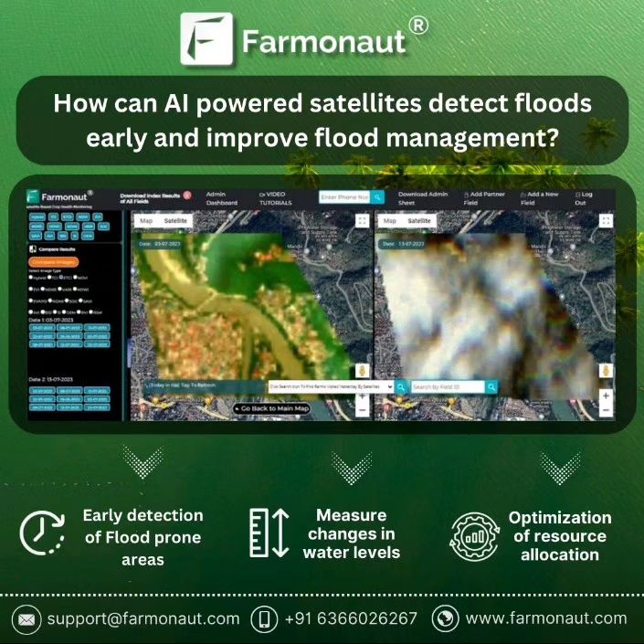
At Farmonaut, we’re pioneering the use of AI and machine learning in conjunction with satellite technology to revolutionize flood management. Our approach leverages the vast potential of these technologies to detect early signs of floods, enabling proactive decision-making and minimizing the impact of such calamities.
1. Monitoring Changes in Land Cover and Vegetation
One of the key ways our AI-powered satellite systems contribute to flood management is through the continuous monitoring of changes in land cover and vegetation. Here’s how it works:
- Satellite Imagery Analysis: Our satellites capture high-resolution images of vast areas at regular intervals.
- AI-Driven Pattern Recognition: Advanced AI algorithms analyze these images, detecting subtle changes in vegetation patterns and land cover.
- Early Warning Indicators: Changes in vegetation health or land cover can often serve as early warning signs of potential flooding.
- Ground Saturation Detection: By analyzing these changes, our system can identify areas where the ground is becoming saturated with water – a crucial indicator of imminent flooding.
This capability allows us to alert relevant authorities and communities well in advance of potential flood events, giving them valuable time to prepare and implement preventive measures.
2. Measuring Changes in Water Levels
Another critical aspect of our flood management system is its ability to measure and track changes in water levels. This feature is particularly vital for predicting and managing flood events:
- Real-Time Water Level Monitoring: Our satellites use advanced sensors to measure water levels in rivers, lakes, and other water bodies.
- AI-Powered Trend Analysis: Machine learning algorithms analyze this data to identify trends and predict potential flood scenarios.
- Critical Level Alerts: The system is designed to issue alerts when water levels approach critical thresholds.
- Flood Progression Tracking: By continuously monitoring water levels, we can track the progress of a flood event in real-time.
This capability allows for more accurate flood predictions and enables authorities to make informed decisions about evacuation and resource allocation.
The Advantages of Satellite-Based Flood Management
Our satellite-based approach to flood management offers several advantages over traditional methods:
| Feature | Farmonaut Satellite System | Drone-based Monitoring | IoT-based Monitoring |
|---|---|---|---|
| Coverage Area | Vast (Global) | Limited (Local) | Limited (Specific points) |
| Real-time Monitoring | Yes | Limited by flight time | Yes, but limited to sensor locations |
| Weather Independence | High | Low (affected by wind, rain) | Moderate |
| Cost-effectiveness | High | Moderate | Low (requires extensive infrastructure) |
| AI Integration | Advanced | Possible, but limited | Possible, but limited |
Practical Applications of AI-Powered Satellite Systems in Flood Management
The applications of our AI-powered satellite systems in flood management are extensive and impactful:
1. Early Warning Systems
By continuously monitoring land cover changes and water levels, our system can provide early warnings of potential flood events. This early detection allows for:
- Timely evacuation of at-risk areas
- Proactive deployment of emergency services
- Implementation of flood mitigation measures
2. Resource Allocation Optimization
With accurate, real-time data on flood progression, authorities can optimize the allocation of resources:
- Directing emergency responders to the most critical areas
- Efficient distribution of relief supplies
- Strategic placement of flood barriers and pumps
3. Long-Term Flood Risk Assessment
Our AI algorithms analyze historical satellite data to identify areas prone to flooding:
- Informing urban planning and development decisions
- Guiding infrastructure investments in flood-prone areas
- Assisting in the development of long-term flood management strategies
4. Environmental Impact Assessment
By monitoring changes in land cover and vegetation, our system can also assess the environmental impact of floods:
- Tracking soil erosion and land degradation
- Monitoring the impact on agricultural lands
- Assessing the effect on natural habitats and ecosystems
The Role of Satellite Color in Flood Detection
An often overlooked but crucial aspect of satellite-based flood detection is the use of satellite color. Our advanced systems utilize multispectral imaging to capture a wide range of color information, which is invaluable in flood detection and management:
- Water Body Identification: Different wavelengths of light are absorbed and reflected differently by water, land, and vegetation. Our AI algorithms analyze these spectral signatures to accurately identify and map water bodies.
- Flood Extent Mapping: By comparing current satellite color data with historical imagery, we can quickly identify areas that are newly inundated, providing accurate maps of flood extent.
- Water Quality Assessment: Changes in water color can indicate changes in water quality, which is crucial for post-flood management and recovery efforts.
- Vegetation Health Monitoring: Satellite color data allows us to assess vegetation health, which can be an early indicator of soil saturation and potential flooding.
Integrating AI-Powered Satellite Systems with Other Technologies
While our AI-powered satellite systems are powerful on their own, their effectiveness is further enhanced when integrated with other technologies:
1. Integration with Ground-Based Sensors
Combining satellite data with information from ground-based sensors provides a more comprehensive picture of flood conditions:
- Real-time water level readings from river gauges
- Soil moisture data from in-situ sensors
- Precipitation data from weather stations
2. Synergy with Weather Forecasting Models
Our AI algorithms incorporate weather forecasting data to improve flood predictions:
- Integrating precipitation forecasts with current soil saturation levels
- Predicting the impact of upcoming weather events on flood risk
- Providing more accurate long-term flood risk assessments
3. Enhancing Hydrological Models
Satellite data significantly improves the accuracy of hydrological models:
- Providing up-to-date information on land cover and topography
- Enhancing river flow and watershed models
- Improving the accuracy of flood extent and depth predictions
The Future of Flood Management with AI and Satellite Technology
As we continue to develop and refine our AI-powered satellite systems, the future of flood management looks increasingly promising:
1. Improved Resolution and Frequency
Advancements in satellite technology will allow for even higher resolution imagery and more frequent data updates, enabling:
- More precise flood mapping and prediction
- Near real-time monitoring of rapidly evolving flood situations
- Better understanding of small-scale hydrological processes
2. Enhanced AI Capabilities
As AI and machine learning technologies continue to evolve, we anticipate significant improvements in:
- Pattern recognition and anomaly detection in satellite imagery
- Predictive modeling of flood events
- Automated decision support systems for flood management
3. Integration with Smart City Technologies
The future will see closer integration of flood management systems with smart city infrastructure:
- Automated flood barrier systems triggered by satellite-based early warnings
- Smart drainage systems that respond to predicted flood events
- Integrated emergency response systems for more effective flood management
Farmonaut’s Commitment to Flood Management
At Farmonaut, we’re committed to leveraging our expertise in satellite technology and AI to contribute to better flood management globally. Our efforts extend beyond technology development to include:
- Partnerships with Government Agencies: We work closely with government bodies to integrate our flood management solutions into their disaster response systems.
- Collaboration with Research Institutions: We actively collaborate with universities and research centers to advance the science of flood prediction and management.
- Community Engagement: We believe in empowering communities with knowledge and tools to better prepare for and respond to flood events.
- Continuous Innovation: Our team is constantly working on improving our algorithms and expanding the capabilities of our satellite-based flood management system.
We invite you to join us in this crucial endeavor. Whether you’re a government agency looking to enhance your flood management capabilities, a researcher interested in collaborating, or a community leader seeking to better protect your area from flood risks, Farmonaut is here to help.
Explore our flood management solutions and other agricultural technologies:
- Farmonaut Mobile App
- Farmonaut Satellite API
- Farmonaut on Google Play
- Farmonaut on App Store
- Farmonaut API Documentation
Subscribe to Farmonaut
Frequently Asked Questions (FAQs)
Q1: How accurate are AI-powered satellite systems in predicting floods?
A1: AI-powered satellite systems have shown remarkable accuracy in predicting floods. By analyzing vast amounts of data from multiple sources, including historical flood patterns, current weather conditions, and real-time satellite imagery, these systems can predict flood events with increasing precision. However, it’s important to note that accuracy can vary depending on factors such as the quality of available data and the specific characteristics of the area being monitored.
Q2: Can these systems work in areas with limited ground-based infrastructure?
A2: Yes, one of the key advantages of satellite-based systems is their ability to monitor vast areas regardless of ground-based infrastructure. This makes them particularly valuable in remote or underdeveloped regions where traditional monitoring methods may be impractical or unavailable.
Q3: How often is satellite data updated for flood monitoring?
A3: The frequency of satellite data updates can vary depending on the specific satellites and systems used. Some satellites provide daily updates, while others may pass over the same area every few days. At Farmonaut, we utilize a combination of satellites to ensure frequent updates, with some data being refreshed multiple times per day in critical areas.
Q4: Can AI-powered satellite systems detect flash floods?
A4: While detecting flash floods presents unique challenges due to their rapid onset, AI-powered satellite systems are increasingly capable of providing early warnings for these events. By analyzing rainfall patterns, soil saturation levels, and topographical data, these systems can identify conditions conducive to flash flooding and issue alerts accordingly.
Q5: How does cloud cover affect satellite-based flood monitoring?
A5: Cloud cover can indeed impact optical satellite imagery. However, modern satellite systems use a variety of sensors, including radar technology, which can penetrate cloud cover. Additionally, AI algorithms are designed to work with partial data and can often infer flood conditions even when some imagery is obscured by clouds.
Q6: Are these systems effective for urban flood monitoring?
A6: Yes, AI-powered satellite systems are effective for urban flood monitoring. They can detect changes in urban landscapes that might contribute to flooding, such as increased impervious surfaces. When combined with high-resolution imagery and urban drainage models, these systems can provide valuable insights for urban flood management.
Q7: How do AI-powered satellite systems contribute to long-term flood risk assessment?
A7: These systems analyze historical satellite data alongside current observations to identify areas prone to flooding. This long-term analysis helps in understanding changing flood patterns, assessing the impact of land use changes on flood risk, and informing long-term flood management strategies and urban planning decisions.
Q8: Can individuals access this flood prediction data?
A8: While much of the detailed analysis is typically used by government agencies and disaster management authorities, Farmonaut is committed to making relevant information accessible to the public. We provide flood risk information through our mobile apps and web platforms, allowing individuals to stay informed about potential flood risks in their area.
Q9: How does Farmonaut’s system compare to traditional flood monitoring methods?
A9: Farmonaut’s AI-powered satellite system offers several advantages over traditional methods. It provides broader coverage, more frequent updates, and the ability to integrate multiple data sources for more comprehensive analysis. Unlike ground-based sensors, our system isn’t vulnerable to damage during flood events, ensuring continuous monitoring even in severe conditions.
Q10: What role does machine learning play in improving flood predictions over time?
A10: Machine learning is crucial in continuously improving flood predictions. As our systems analyze more data over time, they learn to recognize subtle patterns and indicators that might precede flood events. This ongoing learning process enhances the accuracy and reliability of flood predictions, allowing for earlier and more precise warnings.
At Farmonaut, we’re committed to pushing the boundaries of what’s possible in flood management through AI and satellite technology. By combining cutting-edge technology with a deep understanding of environmental processes, we’re working towards a future where the devastating impacts of floods can be significantly mitigated. Join us in this mission to create a safer, more resilient world.
