Revolutionizing Agriculture: Satellite Monitoring and Crop Growth Analysis in Argentina
At Farmonaut, we’re excited to share a recent success story from Argentina that showcases the power of satellite monitoring in modern agriculture. Our platform has recently added two maize fields for satellite monitoring, demonstrating how cutting-edge technology can transform farming practices and boost crop yields.
The Power of Satellite Monitoring in Agriculture
Satellite monitoring has become an indispensable tool in precision agriculture, offering farmers unprecedented insights into their fields. At Farmonaut, we leverage this technology to provide real-time data on crop growth, soil health, and various vegetation indices. One such crucial metric is the EVI index, which we’ll explore in detail in this case study from Argentina.
Case Study: Maize Fields in Argentina
Recently, one of our users in Argentina added two maize fields to our satellite monitoring platform. Let’s take a closer look at these fields and the valuable insights we’ve gained:
- Field 1: 96 hectares
- Field 2: 27 hectares
- Crop: Maize (Corn)
- Growth Stage: Early
- Monitoring Period: August 4, 2020, to August 14, 2020
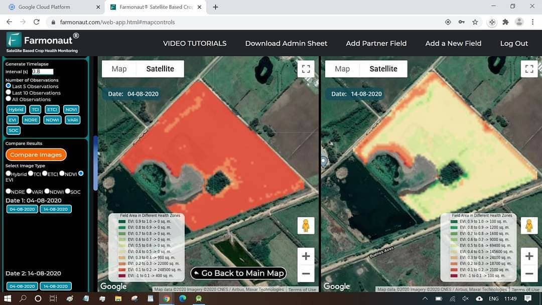
EVI Index Analysis
The Enhanced Vegetation Index (EVI) is a key indicator of crop health and vigor. Our satellite imagery captured the EVI index for these fields over a 10-day period, revealing fascinating insights into the maize crop’s development.
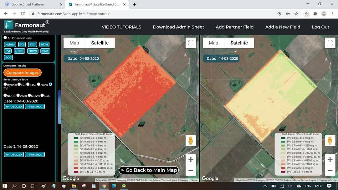
Key Observations
- Overall Crop Health: The majority of both fields showed positive crop growth, indicating healthy development of the maize plants.
- Areas of Concern: Some locations exhibited a lower EVI index, suggesting potential issues with crop establishment or growth.
- Time-lapse Comparison: The side-by-side comparison of images from August 4 to August 14 revealed significant changes in crop vigor across the fields.
Actionable Insights for Farmers
Based on the satellite data, we recommend the following actions for our Argentine farmer:
- Prioritize Field Visits: Areas with low EVI index should be inspected immediately to identify any issues affecting crop growth.
- Consider Recropping: In locations where crop establishment has failed, farmers should evaluate the possibility of recropping to maximize field productivity.
- Optimize Resource Allocation: By focusing efforts on areas of concern, farmers can efficiently allocate resources such as water, fertilizers, and pesticides.
The Impact of Satellite Monitoring on Yield Maximization
At Farmonaut, we firmly believe that data-driven decision-making is key to maximizing agricultural yields. By providing farmers with precise, timely information about their crops, we empower them to make informed choices that can significantly impact their harvest.
Benefits of Satellite Monitoring for Yield Optimization
- Early Problem Detection: Identify issues such as pest infestations, nutrient deficiencies, or irrigation problems before they become severe.
- Targeted Interventions: Apply fertilizers, pesticides, or other treatments only where needed, reducing costs and environmental impact.
- Optimal Harvest Timing: Determine the best time to harvest based on crop maturity across different field sections.
- Resource Efficiency: Improve water and input use efficiency by applying resources based on actual crop needs.
- Historical Data Analysis: Compare current crop performance with previous seasons to identify trends and make long-term improvements.
Farmonaut: Making Precision Agriculture Accessible
At Farmonaut, our mission is to democratize access to advanced agricultural technologies. We believe that every farmer, regardless of the size of their operation, should have the tools to optimize their crop production.
Our Comprehensive Solution
We offer a range of services designed to meet the diverse needs of modern farmers:
- Satellite-Based Crop Monitoring: Regular updates on crop health and growth using advanced vegetation indices.
- AI-Powered Advisory System: Personalized recommendations based on crop type, local conditions, and historical data.
- Weather Forecasting: Accurate, localized weather predictions to help plan farming activities.
- Soil Health Analysis: Insights into soil composition and health to guide fertilization and crop rotation strategies.
- Yield Prediction: Estimate potential yields based on current crop health and historical data.
Farmonaut vs. Traditional Monitoring Methods
While drone and IoT-based monitoring systems have their merits, satellite monitoring offers unique advantages, especially for large-scale operations. Here’s how Farmonaut’s satellite system compares:
| Feature | Farmonaut Satellite System | Drone-based Monitoring | IoT Sensors |
|---|---|---|---|
| Coverage Area | Unlimited | Limited by flight time and regulations | Limited by sensor placement |
| Frequency of Data Collection | Daily to weekly, depending on satellite pass | As needed, but requires manual operation | Continuous, but localized |
| Initial Setup Cost | Low | High (drone purchase, training) | Medium to High (sensor network installation) |
| Operational Complexity | Low (automated data collection and processing) | High (requires skilled pilot and data processing) | Medium (requires maintenance and data management) |
| Data Resolution | Medium to High (improving with new satellites) | Very High | High, but point-specific |
| Scalability | Highly scalable to any farm size | Limited by operational capacity | Requires additional sensors for larger areas |
The Future of Farming: Integrating Satellite Data with On-Ground Practices
As we continue to advance our technology at Farmonaut, we envision a future where satellite monitoring seamlessly integrates with traditional farming practices. This synergy will lead to more sustainable, efficient, and productive agricultural systems worldwide.
Emerging Trends in Satellite-Based Agriculture
- Hyperspectral Imaging: Providing even more detailed insights into crop health and soil composition.
- AI-Driven Predictive Analytics: Forecasting potential issues before they become visible to the human eye.
- Blockchain Integration: Ensuring transparency and traceability in the agricultural supply chain.
- Carbon Sequestration Monitoring: Helping farmers participate in carbon credit markets by quantifying their soil carbon storage.
Case Study: Maximizing Cotton Yields with Satellite Monitoring
While our focus in this blog post has been on maize fields in Argentina, it’s worth noting that Farmonaut’s satellite monitoring technology is equally effective for other crops, including cotton. Let’s briefly explore how our system can help optimize the yield of cotton per hectare.
Satellite Monitoring for Cotton Production
Cotton is a crop that requires careful management throughout its growth cycle. Our satellite monitoring system can provide valuable insights at each stage:
- Planting and Emergence: Monitor field uniformity and identify areas of poor germination early.
- Vegetative Growth: Track nitrogen uptake and water stress to optimize fertilization and irrigation.
- Flowering and Boll Development: Detect pest infestations or nutrient deficiencies that could affect boll formation.
- Harvest Timing: Determine optimal harvest dates based on boll maturity across the field.
Impact on Cotton Yields
By leveraging satellite data, cotton farmers can potentially increase their yields significantly. Here are some ways our technology contributes to higher cotton production:
- Precision Application of Inputs: Apply water, fertilizers, and pesticides only where and when needed, reducing waste and maximizing efficiency.
- Early Stress Detection: Identify and address water stress or nutrient deficiencies before they significantly impact yield.
- Optimized Plant Growth Regulator (PGR) Application: Use vegetation indices to determine the best timing and dosage for PGR application, promoting optimal plant structure for maximum yield.
- Improved Harvest Planning: Identify areas of the field ready for harvest first, allowing for more efficient use of harvesting equipment.
While specific yield increases can vary depending on numerous factors, many cotton farmers using satellite monitoring technologies have reported yield increases of 10-20% or more.
Farmonaut: Your Partner in Precision Agriculture
At Farmonaut, we’re committed to providing farmers with the tools they need to succeed in an increasingly competitive and challenging agricultural landscape. Our platform is designed to be user-friendly and accessible, ensuring that farmers of all technical backgrounds can benefit from our advanced satellite monitoring technology.
How to Get Started with Farmonaut
Ready to revolutionize your farming practices? Here’s how you can get started with Farmonaut:
- Download Our App: Available on both Google Play Store and Apple App Store.
- Web Application: Access our platform directly through your browser at Farmonaut Web App.
- API Integration: For developers looking to integrate our data into their own systems, check out our API documentation.
- Customized Solutions: Contact our team for tailored solutions to meet your specific agricultural needs.
Subscribe to Farmonaut
Ready to take your farming to the next level? Subscribe to Farmonaut and unlock the full potential of satellite-based agriculture:
Conclusion: Embracing the Future of Agriculture
As we’ve seen from our case study in Argentina, satellite monitoring is more than just a technological novelty—it’s a powerful tool that can transform the way we approach farming. By providing real-time, actionable insights into crop health and field conditions, we’re enabling farmers to make data-driven decisions that can significantly impact their yields and profitability.
At Farmonaut, we’re proud to be at the forefront of this agricultural revolution. Our commitment to making precision agriculture accessible to farmers worldwide drives us to continually innovate and improve our services. Whether you’re managing vast maize fields in Argentina, cotton plantations in India, or any other crop anywhere in the world, our satellite monitoring technology can help you optimize your operations and maximize your yields.
As we look to the future, we see endless possibilities for integrating satellite data with on-ground farming practices. From AI-driven predictive analytics to blockchain-based supply chain management, the potential for technology to transform agriculture is immense. And at Farmonaut, we’re excited to be part of this journey, working hand-in-hand with farmers to create a more sustainable, productive, and prosperous agricultural sector.
Join us in embracing the future of farming. Together, we can cultivate success, one satellite image at a time.
FAQs
-
Q: What is satellite monitoring in agriculture?
A: Satellite monitoring in agriculture involves using satellite imagery to observe and analyze crop health, growth patterns, and field conditions. It provides farmers with valuable data to make informed decisions about crop management. -
Q: How often does Farmonaut update its satellite imagery?
A: The frequency of updates depends on satellite availability and orbit patterns, but we typically provide updates every 3-5 days for most locations. -
Q: Can Farmonaut’s technology be used for all types of crops?
A: Yes, our satellite monitoring system can be used for a wide variety of crops, including grains, fruits, vegetables, and cash crops like cotton. -
Q: How accurate is the EVI index in predicting crop health?
A: The EVI index is highly accurate in assessing vegetation health and density. However, it’s most effective when used in conjunction with other data sources and on-ground verification. -
Q: Is Farmonaut’s platform suitable for small-scale farmers?
A: Absolutely! We’ve designed our platform to be accessible and useful for farmers of all scales, from small family farms to large industrial operations. -
Q: How does Farmonaut help in improving crop yields?
A: By providing early detection of issues, optimizing resource use, and enabling precise management practices, Farmonaut helps farmers make decisions that can significantly improve crop yields. -
Q: Can Farmonaut’s data be integrated with other farm management software?
A: Yes, we offer API access that allows for integration with various farm management systems. Check our API documentation for more details. -
Q: How does satellite monitoring compare to drone-based monitoring?
A: While both have their merits, satellite monitoring offers broader coverage, more frequent updates, and lower operational complexity compared to drone-based systems, especially for larger farms. -
Q: Is internet connectivity required to use Farmonaut in the field?
A: While an internet connection is needed to receive updates and access the full platform, our mobile app allows for offline viewing of previously downloaded data. -
Q: How does Farmonaut contribute to sustainable farming practices?
A: By optimizing resource use and enabling precise management practices, Farmonaut helps reduce waste, minimize environmental impact, and promote sustainable farming methods.
Have more questions? Don’t hesitate to reach out to our support team. We’re here to help you make the most of our satellite monitoring technology and take your farming practices to new heights!
