Revolutionizing Agriculture: How Farmonaut’s Satellite Technology is Transforming Farming Practices
In the ever-evolving world of agriculture, technology continues to play a pivotal role in enhancing farming practices and increasing crop yields. At Farmonaut, we’re proud to be at the forefront of this agricultural revolution, offering cutting-edge satellite-based solutions that empower farmers and revolutionize the way we approach farming. Today, we’re excited to delve deep into how our technology is changing the face of agriculture and bringing state-of-the-art tools into the hands of every farmer.
The Power of Satellite Technology in Agriculture
At the heart of Farmonaut’s innovation lies our advanced satellite technology. We harness the power of multispectral satellite imagery to provide farmers with unprecedented insights into their fields. But what exactly does this mean for the average farmer?
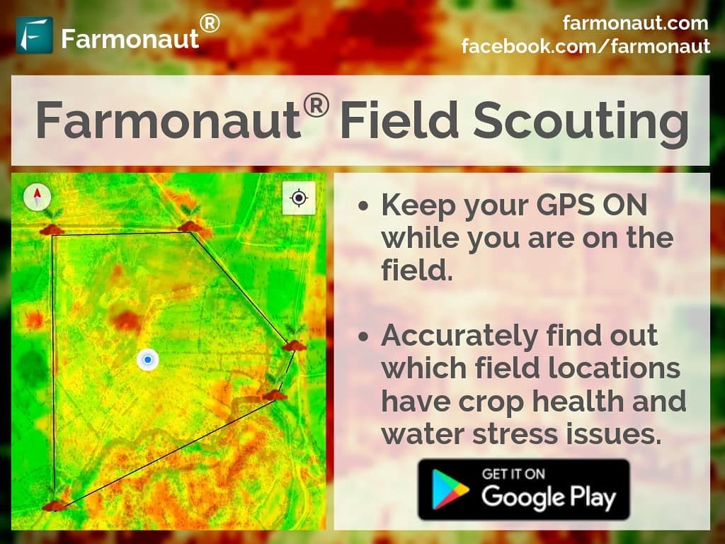
Identifying Unhealthy Vegetation and Water Stress Conditions
One of the most significant advantages of our satellite technology is its ability to
identify unhealthy vegetation and
water stress conditions in fields. Our system uses sophisticated algorithms to analyze satellite cloud pictures and multispectral data, providing a comprehensive view of crop health across entire fields.
- Red and yellow indicators highlight areas of concern
- Easy-to-interpret visual representations of field conditions
- Real-time updates for timely decision-making
By pinpointing these problem areas, we enable farmers to take targeted action, potentially saving entire crops from disease or drought.
Precision in Field Scouting
Gone are the days of walking entire fields to assess crop health. With Farmonaut’s technology, farmers can now:
- Identify specific areas of concern from satellite data
- Plan targeted field visits to problematic areas
- Save time and resources by focusing on areas that need attention
This precision in field scouting not only saves valuable time but also allows for more efficient use of resources, leading to improved overall farm management.
Proactive Farming with Farmonaut
Our technology doesn’t just identify problems; it empowers farmers to take proactive measures to prevent crop issues before they escalate. Here’s how:
Early Problem Detection
By regularly analyzing satellite data, we can detect potential issues in their early stages. This early warning system allows farmers to:
- Address problems before they become severe
- Minimize crop damage and yield loss
- Implement targeted solutions more effectively
Tailored Solutions for Crop Health
Once problem areas are identified, Farmonaut provides guidance on potential remedies. These may include:
- Applying additional fertilizers to boost plant health
- Using plant growth regulators to enhance crop development
- Improving irrigation in water-stressed areas
- Implementing pest control measures in affected regions
By tailoring solutions to specific field areas, farmers can optimize resource use and maximize the effectiveness of their interventions.
The Farmonaut Advantage: Satellite vs. Drone and IoT Monitoring
While drone and IoT-based monitoring systems have their merits, Farmonaut’s satellite system offers distinct advantages. Let’s compare these technologies:
| Feature |
Farmonaut Satellite System |
Drone Monitoring |
IoT-based Monitoring |
| Coverage Area |
Entire farms and regions |
Limited by flight time and regulations |
Limited by sensor placement |
| Frequency of Updates |
Regular updates without manual intervention |
Dependent on manual flights |
Continuous but localized |
| Initial Investment |
Low – No hardware required |
High – Drone purchase and training needed |
Medium to High – Sensors and network setup required |
| Maintenance |
Minimal – Software updates only |
Regular – Hardware maintenance and battery replacement |
Regular – Sensor calibration and replacement |
| Ease of Use |
High – User-friendly app interface |
Medium – Requires piloting skills |
Medium – Requires technical setup and management |
| Data Analysis |
Advanced AI-powered analysis |
Varies based on software used |
Depends on connected analysis tools |
As you can see, Farmonaut’s satellite system offers unparalleled coverage, ease of use, and cost-effectiveness compared to other monitoring methods.
The Farmonaut App: Putting Power in Farmers’ Hands
To make our technology as accessible as possible, we’ve developed the Farmonaut app. This powerful tool brings all the benefits of our satellite technology right to your smartphone.
Key Features of the Farmonaut App:
- Real-time crop health monitoring
- GPS-enabled field scouting
- Customized alerts for potential issues
- Historical data for trend analysis
- Weather forecasts and agricultural advisories
Download the Farmonaut app today:
Get it on Google Play
Download on the App Store
Beyond Crop Monitoring: Farmonaut’s Comprehensive Agricultural Solutions
While our satellite-based crop monitoring is at the core of what we do, Farmonaut offers a range of additional services to support modern farming practices:
1. Jeevn AI Advisory System
Our AI-powered advisory system, Jeevn, provides personalized recommendations based on your specific crop and field conditions. This system analyzes satellite data, weather patterns, and historical information to offer tailored advice on:
- Optimal planting times
- Fertilizer application schedules
- Pest and disease management strategies
- Harvest timing recommendations
2. Blockchain-Based Traceability
In an era where consumers are increasingly concerned about the origin and journey of their food, our blockchain-based traceability system offers unparalleled transparency. This technology allows:
- End-to-end tracking of agricultural products
- Verification of organic and sustainable farming practices
- Enhanced trust between producers, retailers, and consumers
3. Fleet and Resource Management
For larger agricultural operations, our fleet and resource management tools help optimize the use of machinery and other resources. Benefits include:
- Improved logistics planning
- Reduced fuel consumption
- Enhanced equipment maintenance scheduling
- Increased overall operational efficiency
4. Carbon Footprint Tracking
As sustainability becomes increasingly important in agriculture, our carbon footprint tracking feature allows farmers and agribusinesses to:
- Monitor their environmental impact
- Identify areas for reducing emissions
- Demonstrate commitment to sustainable practices
- Potentially access carbon credit markets
The Science Behind Farmonaut’s Satellite Technology
To truly appreciate the power of Farmonaut’s technology, it’s essential to understand the science behind it. Our system relies on advanced remote sensing techniques and multispectral imagery to provide accurate, actionable data.
Multispectral Satellite Imagery
Multispectral imagery captures data from across the electromagnetic spectrum. For agricultural purposes, we focus on several key spectral bands:
- Visible Light (RGB): Provides a visual representation of the field
- Near-Infrared (NIR): Crucial for assessing plant health and biomass
- Short-Wave Infrared (SWIR): Helps in detecting moisture content in soil and vegetation
Normalized Difference Vegetation Index (NDVI)
One of the primary tools we use to assess crop health is the Normalized Difference Vegetation Index (NDVI). This index is calculated using the following formula:
NDVI = (NIR – Red) / (NIR + Red)
NDVI values range from -1 to 1, with higher values indicating healthier vegetation. By analyzing NDVI patterns across a field, we can:
- Identify areas of stress or poor growth
- Monitor crop development over time
- Predict potential yield
Water Stress Detection
To detect
water stress conditions, we utilize a combination of spectral indices and thermal data. Key indicators include:
- Crop Water Stress Index (CWSI): Measures the difference between canopy temperature and air temperature
- Normalized Difference Water Index (NDWI): Assesses vegetation water content
By analyzing these indices, we can provide early warnings of drought stress, allowing farmers to adjust irrigation strategies proactively.
Integrating Farmonaut into Your Farming Practice
Adopting new technology can sometimes be daunting, but we’ve designed Farmonaut to be intuitive and easy to integrate into existing farming practices. Here’s how you can get started:
1. Sign Up and Field Mapping
Begin by signing up for a Farmonaut account and mapping your fields. Our user-friendly interface allows you to:
- Draw field boundaries using satellite imagery
- Input crop types and planting dates
- Set up alerts for specific conditions
2. Regular Monitoring
Once your fields are mapped, our system will begin regular monitoring. We recommend:
- Checking the app at least weekly during the growing season
- Paying close attention to alerts and notifications
- Using the field scouting feature to investigate areas of concern
3. Data-Driven Decision Making
Use the insights provided by Farmonaut to inform your farming decisions. This might include:
- Adjusting irrigation schedules based on water stress data
- Targeting fertilizer application to areas showing nutrient deficiencies
- Planning pest control measures for affected regions
4. Continuous Learning and Optimization
As you use Farmonaut over time, you’ll gain valuable historical data. Use this information to:
- Identify trends in crop performance
- Refine your farming strategies year over year
- Benchmark your results against regional averages
The Future of Farming with Farmonaut
At Farmonaut, we’re committed to continually improving our technology and expanding our offerings. Some exciting developments on the horizon include:
- Enhanced AI-powered predictions: More accurate yield forecasts and pest outbreak predictions
- Integration with IoT devices: Combining satellite data with on-ground sensors for even more precise monitoring
- Advanced crop-specific algorithms: Tailored solutions for a wider range of crops and farming practices
- Expanded blockchain applications: Further enhancing traceability and market connectivity for farmers
As we continue to innovate, our goal remains the same: to make state-of-the-art agricultural technology accessible to farmers of all scales, promoting sustainable and profitable farming practices worldwide.
Join the Farmonaut Community
Ready to revolutionize your farming practice with Farmonaut? Here’s how you can get started:
- Download the Farmonaut app:
Get the app
- Explore our API for developers:
Farmonaut API
- Learn more about our weather API:
Weather API Documentation
Frequently Asked Questions (FAQ)
Q: How often are satellite images updated?
A: Our satellite imagery is typically updated every 3-5 days, depending on weather conditions and satellite availability.
Q: Can Farmonaut be used for all types of crops?
A: Yes, Farmonaut’s technology is applicable to a wide range of crops, including cereals, fruits, vegetables, and cash crops.
Q: Is an internet connection required to use Farmonaut in the field?
A: While an internet connection is needed to receive updates, our app allows you to download data for offline use during field scouting.
Q: How accurate is Farmonaut’s crop health assessment?
A: Our system has been extensively tested and validated, with accuracy rates typically exceeding 90% for crop health assessments.
Q: Can Farmonaut integrate with other farm management software?
A: Yes, we offer API access that allows integration with various farm management platforms.
Q: Is my farm data secure with Farmonaut?
A: Absolutely. We employ state-of-the-art encryption and security measures to protect all user data.
Conclusion: Embracing the Future of Agriculture
As we navigate the challenges of modern agriculture, tools like Farmonaut are becoming increasingly essential. By harnessing the power of satellite technology, artificial intelligence, and data analytics, we’re empowering farmers to make more informed decisions, optimize their resources, and increase their yields sustainably.
From identifying unhealthy vegetation to detecting water stress conditions, from improving irrigation practices to optimizing the use of plant growth regulators, Farmonaut is at the forefront of agricultural innovation. Our commitment to making this technology accessible to farmers of all scales is driving a revolution in farming practices worldwide.
As we look to the future, we’re excited about the potential for further advancements in agricultural technology. With ongoing developments in satellite imagery, AI algorithms, and data analysis techniques, the possibilities for precision agriculture are boundless.
We invite you to join us on this journey towards smarter, more sustainable farming. Whether you’re a small-scale farmer looking to optimize your crop yields or a large agribusiness seeking to enhance your operations, Farmonaut has the tools and expertise to help you succeed.
Together, we can build a future where agriculture is not only more productive but also more sustainable, ensuring food security for generations to come. Join the Farmonaut community today and be part of the agricultural revolution!
