Here’s a comprehensive blog post based on your requirements:
Precision Agriculture 101: Unlocking the Power of Satellite Data for Smarter Farming
Welcome to our in-depth exploration of precision agriculture and the revolutionary impact of satellite data on modern farming practices. At Farmonaut, we’re committed to empowering farmers with cutting-edge technology and data-driven insights. Today, we’re diving into the world of satellite-based farm monitoring, focusing on a real-world example that showcases the power of this technology.
Understanding NDWI: A Key to Water Stress Management
One of the most powerful tools in our precision agriculture arsenal is the Normalized Difference Water Index (NDWI). This index is crucial for quantifying water stress in vegetation, and helping farmers make informed decisions about irrigation and water management.
What is NDWI?
The
Normalized Difference Water Index (NDWI) is a satellite-derived index used to monitor changes in water content of leaves in water-stressed vegetation. It’s an essential tool for precision agriculture, allowing farmers to identify areas of their fields that may require additional irrigation or are at risk of water stress.
NDWI Calculation
For those interested in the technical aspects, the NDWI formula for Sentinel-2 satellite data is:
NDWI = (Band 3 – Band 8) / (Band 3 + Band 8)
Where:
- Band 3 is the green band (560 nm)
- Band 8 is the near-infrared band (842 nm)
This calculation provides a value between -1 and 1, with higher values indicating higher water content in vegetation.
Interpreting NDWI Values
Understanding how to interpret NDWI values is crucial for effective farm management. Here’s a quick guide:
- Dark Green/Green: Good water stress levels, indicating healthy vegetation
- Yellow: Moderate water stress, irrigation may need attention
- Red: High water stress or barren land with no vegetation
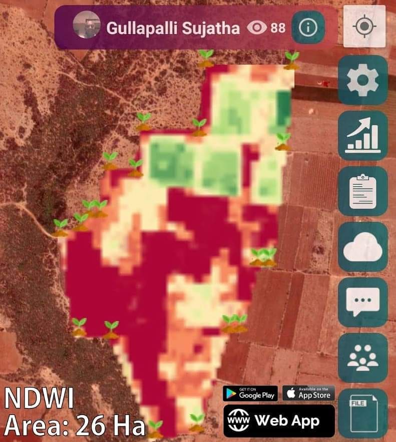
Case Study: Gullapalli Sujatha’s Farm
Let’s examine a real-world application of NDWI in precision agriculture, focusing on the farm of Gullapalli Sujatha, a pioneer in Natural Farming in India.
Farm Details:
- Farmer: Gullapalli Sujatha
- Farm: Viswamatha farms, Andhra Pradesh
- Field Area: 26 Hectares
NDWI Image Analysis
The satellite image of Gullapalli Sujatha’s farm provides valuable insights into the water stress levels across the field:
- The top portion of the field shows good water stress levels (dark green/green areas), indicating healthy vegetation with adequate water content.
- The remaining field areas appear in yellowish or red regions, suggesting that these areas may require attention to irrigation.
This NDWI data allows Gullapalli Sujatha to make informed decisions about water management, focusing irrigation efforts on the areas that need it most. By using this satellite data, farmers like Gullapalli can optimize their water usage, reduce waste, and improve overall crop health.
Benefits of Satellite-Based Precision Agriculture
By leveraging satellite data provided by Farmonaut, farmers can achieve significant improvements in their agricultural practices:
- Reduced Chemical/Fertilizer Consumption: By identifying specific areas where crop health is suboptimal, farmers can apply chemicals and fertilizers only where needed, reducing overall usage and environmental impact.
- Lower Labor Costs: With precise information about field conditions, farmers can direct their workforce more efficiently, focusing efforts on critical areas.
- Water Conservation: NDWI data allows for targeted irrigation, reducing water wastage by applying water only where plant water stress is high.
- Increased Yield: By optimizing resource use and addressing issues promptly, farmers can significantly boost their overall crop yield.
Farmonaut: Making Precision Agriculture Accessible
At Farmonaut, we’re committed to democratizing access to precision agriculture tools. Our platform is designed to be user-friendly and accessible to farmers of all scales. Here’s how we’re making a difference:
- Multi-Platform Accessibility: Our system is available on Android, iOS, and web platforms, ensuring that farmers can access crucial data wherever they are. Download our app today:
Android App
iOS App
- Real-Time Data: Our satellite imagery provides up-to-date information on crop health, allowing for timely interventions.
- AI-Powered Insights: Our Jeevn AI Advisory System offers personalized recommendations based on your farm’s specific conditions.
- Easy Field Navigation: Farmers can use their smartphone’s GPS in conjunction with our satellite images to navigate their fields and pinpoint areas of concern.
Farmonaut vs. Traditional Monitoring Methods
While drone and IoT-based farm monitoring systems have their merits, Farmonaut’s satellite-based system offers unique advantages:
| Feature |
Farmonaut Satellite System |
Drone-based Monitoring |
IoT-based Monitoring |
| Coverage Area |
Large scale (entire farms) |
Limited by flight time and regulations |
Limited by sensor placement |
| Frequency of Data |
Regular updates (every few days) |
Depends on manual flights |
Continuous but localized |
| Initial Investment |
Low (subscription-based) |
High (equipment costs) |
Moderate to High (sensor costs) |
| Ease of Use |
High (no equipment to operate) |
Moderate (requires training) |
Moderate (setup and maintenance required) |
| Data Analysis |
Advanced AI-powered insights |
Varies by software |
Typically basic data visualization |
Expanding the Horizons of Precision Agriculture
While NDWI is a powerful tool, it’s just one aspect of the comprehensive suite of services we offer at Farmonaut. Our platform integrates various technologies to provide a holistic approach to farm management:
1. Blockchain-Based Traceability
We’ve incorporated blockchain technology to ensure complete transparency in the agricultural supply chain. This feature is particularly valuable for:
- Organic farmers who need to verify their practices
- Food processors looking to ensure the quality and origin of their ingredients
- Consumers who want to know the journey of their food from farm to table
2. Carbon Footprint Tracking
In an era where sustainability is paramount, our carbon footprint tracking feature allows farmers and agribusinesses to:
- Monitor their environmental impact in real-time
- Identify areas for reducing emissions
- Comply with environmental regulations
- Potentially access carbon credit markets
3. Fleet and Resource Management
For larger operations, our fleet and resource management tools help:
- Optimize the use of agricultural machinery
- Reduce fuel consumption and operational costs
- Improve overall logistics efficiency
Addressing Unique Farming Challenges
Our technology isn’t just for flat, easy-to-measure fields. We’ve developed solutions for various agricultural scenarios, including challenging terrains.
How to Measure Land in Hilly Areas
Measuring land accurately in hilly or mountainous regions can be challenging, but it’s crucial for effective farm management. Farmonaut’s satellite-based system offers a solution:
- 3D Terrain Modeling: We use high-resolution satellite data to create detailed 3D models of hilly terrains.
- Surface Area Calculation: Our algorithms account for slopes and elevation changes to provide accurate surface area measurements, not just flat projections.
- Contour Mapping: We generate contour maps that help farmers understand the topography of their land and plan accordingly.
- Slope Analysis: This feature helps identify areas prone to erosion or those suitable for specific crops based on incline.
By providing accurate measurements and topographical information for hilly areas, we enable farmers to:
- Plan irrigation systems more effectively
- Implement erosion control measures where needed
- Optimize crop placement based on terrain characteristics
- Accurately estimate inputs needed (seeds, fertilizers, etc.) for true surface area
The Future of Farming with Farmonaut
As we continue to innovate and expand our services, we’re excited about the future of precision agriculture. Here are some areas we’re focusing on:
- Integration with IoT Devices: While our satellite system offers numerous advantages, we’re exploring ways to integrate data from ground-based IoT sensors for even more precise insights.
- Machine Learning Advancements: We’re continuously improving our AI algorithms to provide more accurate predictions and recommendations.
- Climate Change Adaptation: Our research is focused on helping farmers adapt to changing climate patterns using predictive modeling and historical data analysis.
- Crop-Specific Solutions: We’re developing tailored solutions for various crop types, accounting for their unique growth patterns and requirements.
Conclusion
Precision agriculture, powered by satellite technology and AI, is revolutionizing the way we farm. At Farmonaut, we’re proud to be at the forefront of this revolution, providing farmers with the tools they need to optimize their operations, increase yields, and promote sustainability.
From NDWI analysis to blockchain traceability, our comprehensive suite of services is designed to address the complex challenges of modern agriculture. By making these advanced technologies accessible and affordable, we’re empowering farmers of all scales to embrace the future of farming.
Ready to take your farm to the next level?
Get started with Farmonaut today!
FAQs
- Q: How often is the satellite data updated?
A: Our satellite data is typically updated every 3-5 days, depending on weather conditions and satellite availability.
- Q: Can Farmonaut’s system work for small farms?
A: Absolutely! Our system is scalable and designed to benefit farms of all sizes, from small holdings to large commercial operations.
- Q: How accurate is the NDWI data?
A: Our NDWI calculations are highly accurate, with a typical margin of error of less than 5%. However, it’s always best to combine satellite data with ground-level observations for the most comprehensive understanding of your farm’s conditions.
- Q: Do I need special equipment to use Farmonaut’s services?
A: No special equipment is required. All you need is a smartphone or computer with internet access to view and analyze your farm data.
- Q: Can Farmonaut’s system detect specific crop diseases?
A: While our system can identify areas of stress in crops, which may indicate disease, it cannot diagnose specific diseases. However, it can alert you to potential issues early, allowing for timely intervention.
- Q: Is my farm data secure with Farmonaut?
A: Yes, we take data security very seriously. All farm data is encrypted and stored securely, and we never share individual farm data without explicit permission.
- Q: Can Farmonaut’s system work in areas with limited internet connectivity?
A: Our mobile app is designed to work offline once data is downloaded. While an internet connection is needed to receive updates, you can access your farm data in the field even without a constant connection.
- Q: How does Farmonaut support organic farming practices?
A: Our system helps organic farmers by providing detailed insights into crop health and soil conditions without the need for chemical inputs. This data-driven approach supports sustainable and organic farming methods.
- Q: Can Farmonaut’s technology be integrated with other farm management software?
A: Yes, we offer API access that allows for integration with various farm management systems. Contact our support team for more information on integration options.
- Q: How does Farmonaut compare to drone-based farm monitoring?
A: While drones can provide high-resolution imagery, Farmonaut’s satellite-based system offers broader coverage, more frequent updates, and requires no on-farm equipment or expertise to operate. It’s generally more cost-effective and easier to implement, especially for larger areas.
Have more questions? Don’t hesitate to reach out to our support team. We’re here to help you make the most of precision agriculture technology!
