Understanding Precision Agriculture: A Comprehensive Guide to Satellite-Based Farm Management
Welcome to our comprehensive guide on precision agriculture and satellite-based farm management. At Farmonaut, we’re committed to empowering farmers worldwide with cutting-edge technology that revolutionizes agricultural practices. In this blog post, we’ll delve deep into the world of precision agriculture, exploring how satellite data and advanced imaging techniques can transform the way we approach farming.
1. Introduction to Precision Agriculture
Precision agriculture is a farming management concept that uses technology to observe, measure, and respond to variability in crops. The goal is to optimize returns on inputs while preserving resources. At the heart of this approach is the use of information technology and a wide array of items such as GPS guidance, control systems, sensors, robotics, drones, autonomous vehicles, variable rate technology, GPS-based soil sampling, automated hardware, telematics, and software.
One of the most powerful tools in precision agriculture is remote sensing. This technology allows farmers to gather data about their fields without physical contact. Satellite imagery is a prime example of remote sensing, providing valuable insights into crop health, soil conditions, and more.
2. Understanding Satellite Imagery in Agriculture
Satellite imagery has become an indispensable tool in modern agriculture. It provides farmers with a bird’s-eye view of their fields, offering insights that would be impossible to gather from ground level. Here are some key types of satellite imagery used in agriculture:
- True Color Images (TCI): These images show the earth as it would appear to the human eye from space.
- Enhanced True Color Images (ETCI): A processed version of TCI that enhances land features for better visibility.
- Normalized Difference Vegetation Index (NDVI): This index measures the health and density of vegetation.
- Visible Atmospherically Resistant Index (VARI): An index that’s resistant to atmospheric effects, making it ideal for assessing vegetation in various environmental conditions.
These different types of imagery allow farmers to gain comprehensive insights into their fields, helping them make informed decisions about crop management.
3. Enhanced True Color Image (ETCI) Explained
At Farmonaut, we utilize Enhanced True Color Images (ETCI) to provide our farmers with the clearest possible view of their fields. ETCI is essentially a True Color Image (TCI) that has been processed by our advanced systems to enhance land features that might not be explicitly visible in the raw TCI.
The benefits of ETCI include:
- Improved clarity of field features
- Better distinction between different types of vegetation
- Enhanced visibility of soil characteristics
- Clearer identification of problem areas in the field
However, it’s important to note that ETCI, like TCI, can be affected by atmospheric conditions such as clouds or haze. In such cases, we turn to more robust indices like VARI to ensure accurate vegetation assessment.
4. Visible Atmospherically Resistant Index (VARI) and Its Importance
The Visible Atmospherically Resistant Index (VARI) is a crucial tool in our arsenal of satellite data analysis techniques. VARI is designed to be minimally affected by atmospheric conditions, making it an ideal choice for farm-level decision making when other indices are compromised by atmospheric distortions.
Key features of VARI:
- Resistant to atmospheric effects like mild clouds or haze
- Provides reliable vegetation estimates in a wide variety of environments
- Uses visible light spectrum, making it applicable to a broader range of satellite sensors
- Easy to interpret color scheme for quick assessment of crop health
The color scheme used in VARI images is intuitive and easy to interpret:
- Dark Green/Green: Indicates very healthy crop
- Yellow: Suggests that the crop needs attention
- Red: Represents barren land or areas with very poor crop health
This color-coded system allows farmers to quickly identify areas of concern in their fields, enabling targeted interventions and more efficient resource allocation.
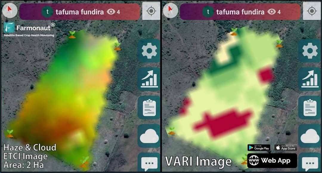
5. Case Study: Tafuma Fundira’s Farm in Zimbabwe
Let’s examine a real-world application of our satellite imaging technology by looking at the farm of Tafuma Fundira in Masvingo, Zimbabwe. This case study demonstrates how our ETCI and VARI images provide valuable insights for farm management.
Farm Details:
- Farmer: Tafuma Fundira
- Location: Masvingo, Zimbabwe
- Field Area: 2 Hectares
Image Analysis:
In the satellite imagery of Tafuma’s farm, we can observe:
- ETCI Image (Left): The image appears distorted due to haze and clouds. This atmospheric interference makes it challenging to accurately assess crop health using this image alone.
- VARI Image (Right): This image provides a clearer picture of the field’s condition:
- A majority of the field shows as green, indicating healthy crop growth.
- Some areas appear in red, representing barren regions or areas of poor crop health.
This comparison illustrates why VARI is crucial in situations where atmospheric conditions affect the clarity of standard color images. The VARI image allows Tafuma to identify specific areas of his field that require attention, enabling targeted interventions and more efficient resource use.
Practical Application:
We recommend that farmers like Tafuma use their smartphone’s GPS in conjunction with these images to navigate their fields. This allows for precise location of problem areas identified in the VARI image, enabling targeted actions such as:
- Focused application of fertilizers or pesticides
- Directed irrigation efforts
- Targeted soil sampling for further analysis
By combining satellite imagery with on-the-ground observations, farmers can make more informed decisions about their crop management strategies, ultimately leading to improved yields and resource efficiency.
6. Benefits of Satellite-Based Farm Management
Adopting satellite-based farm management techniques, like those offered by Farmonaut, can provide numerous benefits to farmers. Let’s explore these advantages in detail:
1. Reduced Chemical and Fertilizer Consumption
By using precise satellite data to identify areas of poor crop health, farmers can apply chemicals and fertilizers only where they’re needed most. This targeted approach not only reduces costs but also minimizes the environmental impact of farming practices.
2. Lower Labor Costs
With accurate field maps provided by satellite imagery, farmers can direct their workforce more efficiently. Labor can be focused on areas that require immediate attention, reducing unnecessary work and associated costs.
3. Optimized Irrigation
Satellite-based monitoring helps identify areas of water stress in crops. This information allows farmers to apply irrigation water more precisely, reducing waste and ensuring that all parts of the field receive adequate moisture.
4. Increased Overall Yield
By addressing issues promptly and optimizing resource use, farmers can significantly improve their crop yields. The early detection of problems through remote sensing allows for timely interventions, potentially saving crops that might otherwise have been lost.
5. Improved Decision Making
Access to real-time, accurate data about field conditions empowers farmers to make more informed decisions. This data-driven approach can lead to better long-term planning and more sustainable farming practices.
6. Environmental Sustainability
By optimizing the use of resources like water, fertilizers, and pesticides, satellite-based farm management contributes to more environmentally friendly farming practices. This not only benefits the planet but can also help farmers comply with environmental regulations.
7. Time Savings
Satellite imagery provides a quick and comprehensive overview of field conditions, saving farmers the time and effort of manual field scouting. This efficiency allows farmers to focus on other important aspects of farm management.
8. Historical Data Analysis
Over time, the accumulation of satellite data allows for historical analysis of field performance. This can reveal long-term trends and patterns, helping farmers make strategic decisions about crop rotation, variety selection, and other long-term planning aspects.
7. Farmonaut’s Approach to Precision Agriculture
At Farmonaut, we’re dedicated to making precision agriculture accessible and affordable for farmers worldwide. Our approach combines cutting-edge technology with user-friendly interfaces to deliver powerful farm management tools. Here’s how we’re revolutionizing agriculture:
Satellite-Based Crop Health Monitoring
We utilize multispectral satellite imagery to provide comprehensive crop health assessments. Our platform offers various vegetation indices, including NDVI and VARI, to give farmers a complete picture of their fields’ condition.
AI-Powered Advisory System
Our Jeevn AI system analyzes satellite data along with other inputs to provide personalized farm advice. This includes weather forecasts, crop management strategies, and real-time insights to help farmers make informed decisions.
Blockchain-Based Traceability
We’ve integrated blockchain technology to ensure transparency and security in agricultural supply chains. This feature is particularly valuable for corporate clients looking to verify the origin and journey of their agricultural products.
Resource Management Tools
Our platform includes tools for fleet and resource management, helping agribusinesses optimize their operations and reduce costs.
Environmental Monitoring
We offer carbon footprint tracking to help businesses monitor and reduce their environmental impact, promoting sustainable farming practices.
Accessibility
Our services are available on multiple platforms, including web, Android, and iOS, ensuring that farmers can access vital information anytime, anywhere. You can download our app from the Google Play Store or the Apple App Store.
API Access
For developers and businesses looking to integrate our data into their own systems, we offer API access. You can find our API documentation here.
8. Comparing Satellite, Drone, and IoT-Based Farm Monitoring
When it comes to precision agriculture, there are several technologies available for farm monitoring. Let’s compare satellite-based systems like Farmonaut with drone and IoT-based solutions:
| Feature | Farmonaut Satellite System | Drone-based Monitoring | IoT-based Monitoring |
|---|---|---|---|
| Coverage Area | Large (entire farms at once) | Medium (limited by flight time) | Small (depends on sensor placement) |
| Frequency of Data Collection | Regular (based on satellite revisit time) | On-demand (requires manual flights) | Continuous (real-time data) |
| Initial Setup Cost | Low | High (drone purchase required) | Medium to High (sensors needed) |
| Operational Complexity | Low (automated data collection) | High (requires skilled operator) | Medium (maintenance of sensors) |
| Weather Dependency | Moderate (some indices work in various conditions) | High (cannot fly in bad weather) | Low (operates in most conditions) |
| Data Processing | Automated (AI-powered analysis) | Manual or semi-automated | Automated (requires setup) |
| Scalability | High (easily scalable to large areas) | Low to Medium | Medium (requires additional sensors) |
While each system has its advantages, Farmonaut’s satellite-based solution offers a unique combination of wide coverage, low operational complexity, and high scalability, making it an excellent choice for farmers of all sizes.
9. How to Get Started with Farmonaut
Ready to revolutionize your farming practices with Farmonaut? Here’s how you can get started:
- Sign Up: Visit our website at https://farmonaut.com/app_redirect to create your account.
- Choose Your Plan: Select the subscription plan that best fits your needs. We offer flexible options for farms of all sizes.
- Download the App: Get our mobile app from the Google Play Store or the Apple App Store.
- Map Your Fields: Use our intuitive interface to map your fields and start receiving satellite data.
- Explore the Data: Dive into the wealth of information provided by our satellite imagery and AI-powered insights.
- Implement Changes: Use the insights gained to make data-driven decisions about your farm management practices.
For those interested in integrating our data into their own systems, check out our API documentation at https://farmonaut.com/farmonaut-satellite-weather-api-developer-docs/.
Subscribe to Farmonaut
10. FAQs
Q: How often is satellite data updated?
A: The frequency of satellite data updates depends on the satellite constellation and your subscription plan. Typically, we provide updates every 3-5 days, but this can vary based on weather conditions and satellite availability.
Q: Can Farmonaut’s system work for small farms?
A: Absolutely! Our system is designed to be scalable and can provide valuable insights for farms of all sizes, from small family plots to large commercial operations.
Q: How accurate is satellite-based crop health monitoring?
A: Satellite-based monitoring can be highly accurate, especially when using indices like VARI that are resistant to atmospheric interference. However, it’s always best to combine satellite data with on-the-ground observations for the most comprehensive understanding of your fields.
Q: Does Farmonaut offer training on how to use the system?
A: Yes, we provide comprehensive training materials, including video tutorials and user guides. Our customer support team is also available to assist you in getting the most out of our platform.
Q: Can Farmonaut’s system help with crop insurance claims?
A: Yes, our satellite data can provide valuable evidence for crop insurance claims by documenting field conditions over time. This historical data can help substantiate claims related to weather events or other crop losses.
Q: Is internet connectivity required to use Farmonaut in the field?
A: While an internet connection is needed to receive the latest updates, our mobile app allows you to download field maps for offline use. This ensures you can access critical information even in areas with poor connectivity.
Conclusion
Precision agriculture, powered by advanced satellite technology, is revolutionizing the way we approach farming. At Farmonaut, we’re proud to be at the forefront of this agricultural revolution, providing farmers with the tools they need to optimize their operations, increase yields, and promote sustainable practices.
By leveraging the power of satellite data, advanced indices like VARI and NDVI, and cutting-edge remote sensing techniques, we’re enabling farmers to gain unprecedented insights into their fields’ crop health and overall condition.
We invite you to join us on this journey towards smarter, more efficient farming. Whether you’re a small family farmer or managing a large agricultural operation, Farmonaut has the tools and expertise to help you take your farming practices to the next level.
Ready to transform your farming experience? Sign up for Farmonaut today and discover the power of precision agriculture!
