Revolutionizing Field Monitoring: Farmonaut’s Side-by-Side Image Comparison Feature
In the ever-evolving world of precision agriculture, we at Farmonaut are constantly striving to provide innovative solutions that empower farmers and agricultural professionals. Today, we’re excited to introduce our latest feature that’s set to transform the way you monitor and analyze your fields: the side-by-side image comparison tool.
Understanding the Power of Image Comparison in Agriculture
Before we dive into the specifics of our new feature, let’s explore why image comparison is such a crucial tool in modern farming practices.
The Importance of Visual Data in Agriculture
In the realm of agriculture, visual data plays a pivotal role in decision-making processes. Farmers and agronomists rely heavily on visual cues to assess crop health, soil conditions, and overall field performance. Historically, this meant walking the fields and making observations with the naked eye. While this method is still valuable, it has limitations in terms of efficiency and accuracy, especially when dealing with large-scale operations.
Enter Remote Sensing Technology
Remote sensing has revolutionized the way we gather agricultural data. By utilizing satellite imagery, drones, and other advanced technologies, we can now collect vast amounts of visual information without setting foot in the field. This technology allows for:
- Frequent and consistent monitoring of large areas
- Detection of issues that may not be visible to the human eye
- Historical data collection for trend analysis
- Reduced time and labor costs associated with manual field scouting
The Role of Image Comparison in Agricultural Analysis
While single images provide valuable snapshots of field conditions, the ability to compare images over time opens up a whole new dimension of analysis. Image comparison allows farmers and agricultural professionals to:
- Track changes in crop health and development
- Identify areas of concern before they become major issues
- Assess the effectiveness of various agricultural practices
- Make data-driven decisions about resource allocation
Introducing Farmonaut’s Side-by-Side Image Comparison Feature
At Farmonaut, we understand the critical role that visual data plays in modern agriculture. That’s why we’re thrilled to announce our new side-by-side image comparison feature, designed to make field monitoring more intuitive and insightful than ever before.
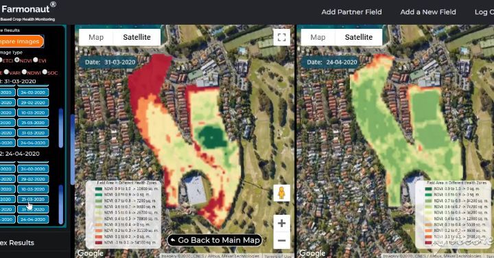
What is the Side-by-Side Image Comparison Feature?
Our new feature allows users to select any two dates of satellite visits and compare the resulting images simultaneously on the Farmonaut web app map interface. This side-by-side view provides a powerful tool for observing changes in your fields over time, enabling you to make more informed decisions about crop management and resource allocation.
Key Benefits of the Side-by-Side Comparison Tool
- Effortless Temporal Analysis: Easily track changes in your fields over days, weeks, or months.
- Enhanced Decision Making: Identify trends and patterns that may not be apparent from single images.
- Improved Efficiency: Reduce the time spent on manual field scouting and data analysis.
- Greater Insight: Gain a deeper understanding of how various factors affect your crops over time.
How to Use the Side-by-Side Comparison Feature
Using our new comparison tool is simple and intuitive. Here’s a step-by-step guide:
- Log in to your Farmonaut account at https://farmonaut.com/app_redirect.
- Navigate to the field you wish to analyze.
- Click on the “Compare Images” option in the toolbar.
- Select two dates from the available satellite imagery.
- The images will appear side-by-side on your screen, allowing for easy comparison.
It’s that simple! With just a few clicks, you can gain valuable insights into the temporal changes occurring in your fields.
Applications of Side-by-Side Image Comparison in Agriculture
The ability to compare field images side-by-side opens up a world of possibilities for agricultural analysis and decision-making. Let’s explore some of the key applications of this powerful tool.
1. Crop Health Monitoring
One of the most significant applications of image comparison is in monitoring crop health over time. By comparing images taken at different stages of the growing season, farmers can:
- Detect early signs of stress or disease
- Track the progression of crop development
- Identify areas of the field that may require additional attention
For example, a farmer might compare images taken before and after a period of drought to assess its impact on crop health. This information can be invaluable in making decisions about irrigation strategies or potential yield estimates.
2. Assessing the Effectiveness of Agricultural Practices
Side-by-side image comparison is an excellent tool for evaluating the effectiveness of various agricultural practices. Farmers can use this feature to:
- Compare different fertilization methods
- Assess the impact of pest control measures
- Evaluate the success of new crop varieties
By comparing images before and after implementing a new practice, farmers can gain concrete visual evidence of its effectiveness, helping to inform future decision-making.
3. Soil Management
Soil health is a critical factor in agricultural success. Our side-by-side comparison tool can help farmers monitor soil conditions over time, allowing them to:
- Track changes in soil moisture levels
- Identify areas of erosion or compaction
- Assess the effectiveness of soil conservation practices
This information can be crucial in developing sustainable soil management strategies that maintain long-term field productivity.
4. Yield Prediction and Harvest Planning
By comparing images throughout the growing season, farmers can make more accurate yield predictions and plan their harvests more effectively. This application allows for:
- Early identification of high-yield areas
- More precise estimation of overall crop yields
- Optimized harvest timing based on crop maturity across the field
These insights can help farmers make informed decisions about resource allocation, labor planning, and market strategies.
5. Disaster Assessment and Recovery
In the event of natural disasters or extreme weather events, side-by-side image comparison can be an invaluable tool for assessing damage and planning recovery efforts. Farmers can use this feature to:
- Quantify the extent of crop damage
- Identify areas that require immediate attention
- Track the progress of recovery efforts over time
This information can be crucial not only for on-farm decision-making but also for insurance claims and disaster relief applications.
Farmonaut’s Satellite System vs. Drone and IoT-based Farm Monitoring
While drones and IoT devices have their place in modern agriculture, Farmonaut’s satellite-based system offers unique advantages for farm monitoring. Let’s compare these technologies:
| Feature | Farmonaut Satellite System | Drone-based Monitoring | IoT-based Monitoring |
|---|---|---|---|
| Coverage Area | Large-scale (entire farms or regions) | Limited by flight time and regulations | Limited to sensor placement |
| Frequency of Data Collection | Regular intervals (3-5 days) | As needed, but requires manual operation | Continuous, real-time data |
| Initial Setup Cost | Low (subscription-based) | High (equipment purchase) | Moderate to High (sensors and network) |
| Maintenance Requirements | Minimal (managed by Farmonaut) | High (equipment maintenance, pilot training) | Moderate (sensor maintenance, battery replacement) |
| Data Processing | Automated with AI and machine learning | Often requires manual processing | Automated, but limited to sensor capabilities |
| Weather Dependency | Less affected by local weather conditions | Highly dependent on weather for flights | Generally unaffected, but sensors may be impacted |
| Historical Data Analysis | Extensive historical data available | Limited to flight history | Dependent on data storage capabilities |
As you can see, while each technology has its strengths, Farmonaut’s satellite-based system offers a comprehensive, cost-effective, and low-maintenance solution for large-scale farm monitoring.
Integrating Farmonaut’s Side-by-Side Comparison with Other Smart Farming Practices
The true power of Farmonaut’s side-by-side image comparison feature is fully realized when integrated with other smart farming practices. Let’s explore how this tool can complement and enhance various aspects of precision agriculture.
1. Precision Irrigation
Water management is a critical component of modern agriculture. By combining our side-by-side comparison tool with precision irrigation systems, farmers can:
- Identify areas of water stress or overwatering
- Track the effectiveness of irrigation schedules
- Optimize water usage based on historical and current field conditions
This integration can lead to significant water savings and improved crop health.
2. Variable Rate Technology (VRT)
Variable Rate Technology allows for the precise application of inputs such as fertilizers and pesticides. When combined with our image comparison feature, VRT becomes even more powerful:
- Use historical comparisons to create more accurate prescription maps
- Assess the effectiveness of variable rate applications over time
- Fine-tune VRT strategies based on observed field responses
This integration can lead to optimized input use, reduced costs, and improved crop yields.
3. Crop Rotation Planning
Effective crop rotation is essential for maintaining soil health and managing pests and diseases. Our side-by-side comparison tool can aid in crop rotation planning by:
- Providing visual evidence of the impact of different crops on field conditions
- Helping identify patterns of soil depletion or improvement over multiple seasons
- Assisting in the selection of optimal crop sequences based on historical field performance
4. Integrated Pest Management (IPM)
IPM is a holistic approach to pest control that aims to minimize chemical interventions. By integrating our image comparison feature with IPM practices, farmers can:
- Detect early signs of pest infestations or disease outbreaks
- Track the spread of pests or diseases across the field over time
- Assess the effectiveness of various pest control measures
This integration can lead to more targeted and effective pest management strategies, reducing the need for broad-spectrum pesticide applications.
5. Climate-Smart Agriculture
As climate change continues to impact agriculture, adapting farming practices becomes increasingly important. Our side-by-side comparison tool can support climate-smart agriculture by:
- Helping farmers visualize the long-term impacts of changing weather patterns on their fields
- Assisting in the evaluation of climate-resilient crop varieties and practices
- Supporting decision-making around adaptation strategies such as altered planting dates or new crop selections
The Future of Field Monitoring with Farmonaut
At Farmonaut, we’re committed to continually improving our platform to meet the evolving needs of farmers and agricultural professionals. As we look to the future, we see several exciting developments on the horizon:
1. Enhanced AI-Powered Analysis
We’re working on integrating advanced artificial intelligence algorithms that will automatically analyze side-by-side comparisons and provide actionable insights. This could include:
- Automatic detection of anomalies or concerning changes
- Predictive analytics based on historical image data
- AI-generated recommendations for crop management
2. Integration with Internet of Things (IoT) Devices
While our satellite-based system offers numerous advantages, we recognize the value of on-the-ground data. We’re exploring ways to integrate data from IoT devices such as soil sensors and weather stations with our satellite imagery. This integration could provide:
- More comprehensive field insights
- Ground-truthing of satellite data
- Enhanced precision in decision-making
3. Expanded Temporal Analysis Tools
Building on our side-by-side comparison feature, we’re developing more advanced temporal analysis tools. These could include:
- Time-lapse visualizations of field changes
- Multi-year trend analysis
- Seasonal comparison tools
4. Mobile Optimization
We’re working on optimizing our side-by-side comparison feature for mobile devices, allowing farmers to access this powerful tool directly from the field. Our mobile apps are available for both Android and iOS platforms:
- Android: Farmonaut on Google Play
- iOS: Farmonaut on the App Store
5. Enhanced Data Export and Integration
We’re developing more robust data export features and APIs to allow for seamless integration with other farm management software. This will enable farmers to incorporate our insights into their broader agricultural data ecosystem. For developers interested in integrating Farmonaut’s data into their own applications, we offer comprehensive API documentation:
Conclusion: Empowering Farmers with Advanced Monitoring Tools
The introduction of our side-by-side image comparison feature marks a significant step forward in our mission to make precision agriculture accessible and affordable for farmers worldwide. By providing easy-to-use, powerful tools for field monitoring and analysis, we’re empowering farmers to make more informed decisions, optimize their resources, and ultimately increase their productivity and profitability.
As we continue to innovate and expand our offerings, we remain committed to supporting sustainable agriculture practices that benefit both farmers and the environment. We believe that by combining cutting-edge technology with agronomic expertise, we can help address the global challenges of food security and environmental sustainability.
We invite you to experience the power of Farmonaut’s side-by-side image comparison feature for yourself. Whether you’re managing a small family farm or overseeing large-scale agricultural operations, our platform has the tools you need to take your farming practices to the next level.
Ready to Transform Your Farm Management?
Subscribe to Farmonaut today and start leveraging the power of satellite-based field monitoring and our new side-by-side comparison feature:
Frequently Asked Questions (FAQ)
Q: How often are satellite images updated in Farmonaut?
A: Our satellite imagery is typically updated every 3-5 days, depending on weather conditions and satellite availability.
Q: Can I compare images from different seasons?
A: Yes, our side-by-side comparison tool allows you to select any two dates with available imagery, including across different seasons or years.
Q: Is Farmonaut’s satellite monitoring suitable for small farms?
A: Absolutely! Our platform is designed to be scalable and accessible for farms of all sizes, from small family operations to large-scale commercial farms.
Q: How accurate is the satellite imagery compared to drone footage?
A: While drone footage can provide higher resolution for small areas, our satellite imagery offers comparable accuracy for most agricultural applications, with the added benefits of covering larger areas more frequently and at a lower cost.
Q: Can I integrate Farmonaut’s data with my existing farm management software?
A: Yes, we offer API access that allows for integration with various farm management systems. For more information, please refer to our API documentation.
Q: Is training required to use the side-by-side comparison feature?
A: The feature is designed to be intuitive and user-friendly. However, we provide comprehensive user guides and customer support to ensure you can make the most of our platform.
Q: How does Farmonaut’s satellite monitoring compare to IoT sensors in terms of cost?
A: Farmonaut’s satellite-based monitoring typically offers a more cost-effective solution, especially for larger areas, as it doesn’t require the installation and maintenance of physical sensors across your fields.
Q: Can Farmonaut’s system detect specific crop diseases?
A: While our system can detect anomalies and changes in crop health that may indicate disease, specific disease identification often requires additional on-the-ground verification. However, our alerts can help you target your field scouting efforts more effectively.
Q: Is my farm data secure with Farmonaut?
A: Yes, we take data security very seriously. All farm data is encrypted and stored securely, and we adhere to strict privacy policies to protect our users’ information.
Q: Can I use Farmonaut for organic farming?
A: Absolutely! Our satellite monitoring and analysis tools are equally valuable for organic farming operations, helping to optimize resource use and monitor crop health without relying on chemical inputs.
We hope this comprehensive guide has given you a clear understanding of Farmonaut’s new side-by-side image comparison feature and its potential to revolutionize your farming practices. Remember, in the world of agriculture, knowledge is power, and with Farmonaut, that power is at your fingertips. Happy farming!
