🌍 Introduction to Satellite Imaging in Agriculture
In the rapidly evolving world of agricultural technology, leveraging satellite images API has become a game-changer for farmers, agricultural platforms, and technology developers. This comprehensive guide will walk you through the process of utilizing our powerful API to retrieve and analyze satellite image data for agricultural fields, empowering you to make data-driven decisions and optimize farm management.
Whether you’re developing a native mobile app for the agriculture technology industry or seeking to integrate satellite weather data into your existing systems, this tutorial will provide you with the knowledge and tools to dynamically access and utilize this crucial information.
🛰️ Understanding Sense Days and Satellite Visits
At the core of satellite imaging for agriculture is the concept of “sense days” – the specific days when satellite visits occur. These dates are crucial for obtaining accurate and timely data about your fields. Let’s explore how to use the getSenseDays endpoint to fetch this vital information.
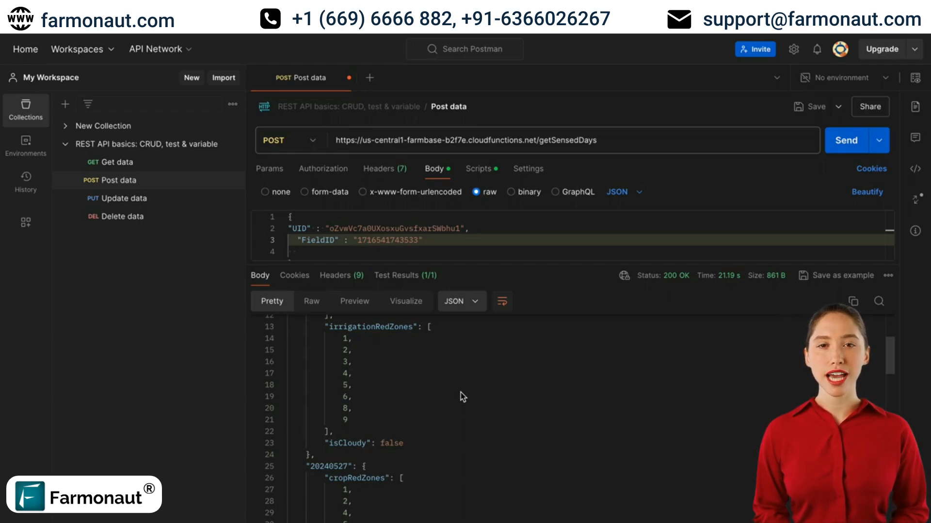
Using the getSenseDays Endpoint
To retrieve sense days data, you’ll need to use the getSenseDays endpoint. Here’s what you need to know:
- Required parameters: uid and field ID
- Optional parameter: polygon ID
The response will include:
- Sense day date (format: year-month-day)
- Crop red zones
- Irrigation red zones
- Weather conditions (cloudy or not)
This information is crucial for determining when satellite data is available and what type of data you can expect for each date.
☁️ Handling Cloudy Weather with SAR Data
When traditional satellite data is unavailable due to cloud cover, we turn to Synthetic Aperture Radar (SAR) data. SAR technology can penetrate clouds, providing valuable insights even on overcast days.
Implementing the getSARDays Endpoint
To fetch SAR data, use the getSARDays endpoint:
- Required parameters: uid and field ID
This endpoint will return available SAR data dates for the specified field.
Pro tip: Develop an algorithm that dynamically switches between regular satellite data and SAR data based on weather conditions. This will ensure your farm data API always provides the most accurate and up-to-date information to users.
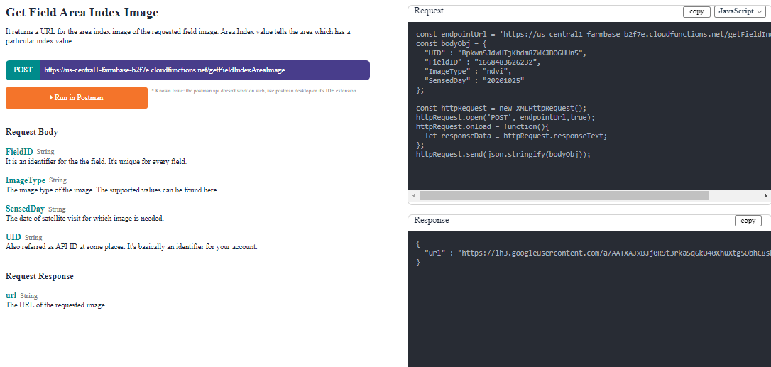
📸 Fetching Satellite Images with getFieldImage
Once you have the sense days or SAR days, you can retrieve specific satellite images using the getFieldImage endpoint. This is crucial for analyzing crop health and irrigation needs.
Using the getFieldImage Endpoint
To fetch a satellite image, you’ll need to provide:
- uid
- field ID
- image type (e.g., NDVI, RVI, RSM)
- sense date
- color map (optional)
The response will include a URL to the requested satellite image. Remember to use NDVI for clear weather and RVI for cloudy conditions when assessing crop health.
📊 Analyzing Index Values for Agricultural Insights
To gain deeper insights into your fields, you’ll want to analyze specific index values. Our API provides several endpoints for this purpose.
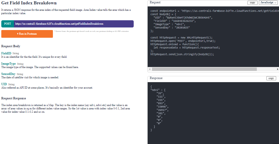
Using getFieldIndexBreakdown
This endpoint allows you to see how much area of your field falls within different index value ranges. For example, you can determine how much of your field has an NDVI value between 0 and 0.1, 0.1 to 0.2, and so on.
Fetching Specific Index Values with getIndexValue
When you need the value of a particular index on a specific day, use the getIndexValue endpoint. This is useful for tracking changes in crop health or water stress over time.
📈 Comprehensive Data Retrieval with getAllIndexValues
For a complete picture of your field’s health and conditions over time, use the getAllIndexValues endpoint. This powerful tool retrieves data for all available indices and dates for a given field.
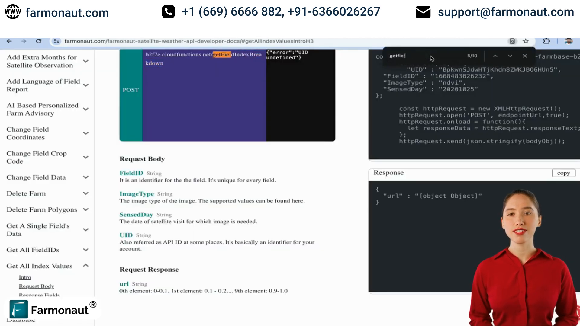
This comprehensive data set is invaluable for creating detailed reports, tracking long-term trends, and making informed decisions about crop management.
📄 Generating PDF Reports of Satellite Visits
To compile and share your satellite data findings, our API offers the ability to generate detailed PDF reports. These reports provide a comprehensive overview of satellite visits and field conditions.
Using the getFieldReport Endpoint
To generate a PDF report, you’ll need to provide:
- uid
- field ID
- sense date
- report format (PDF)
- language
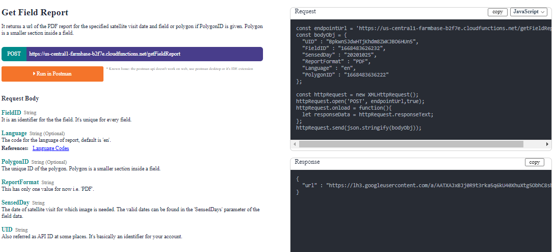
The response will include a URL to download the generated PDF report, which you can then share with stakeholders or use for your own analysis.
🚀 Integrating Satellite Images API into Your Agricultural Technology Stack
Now that you understand the key endpoints and functionalities of our satellite images API, it’s time to consider how to integrate this powerful tool into your agricultural technology stack. Whether you’re developing a native mobile app for the agriculture technology industry or enhancing an existing farm management system, here are some tips for seamless integration:
- Implement dynamic data switching between satellite and SAR data based on weather conditions
- Create visualizations of index values to help farmers quickly assess field health
- Set up automated alerts based on significant changes in index values
- Integrate satellite data with other farm data sources for comprehensive analysis
- Use the PDF report generation feature to create regular field health summaries
❓ Frequently Asked Questions
Q: How often is satellite data updated?
A: Satellite visits typically occur every 3 to 5 days, depending on the location. You can use the getSenseDays endpoint to get the exact dates for your specific fields.
Q: What should I do if satellite data is unavailable due to cloud cover?
A: In cases of cloud cover, switch to SAR (Synthetic Aperture Radar) data using the getSARDays endpoint. SAR can penetrate clouds and provide valuable insights even in overcast conditions.
Q: Can I get historical satellite data for my fields?
A: Yes, you can use the getAllIndexValues endpoint to retrieve historical data for all available indices and dates for a given field.
Q: How can I use this API to improve my harvest forecast?
A: By regularly analyzing NDVI and other vegetation indices, you can track crop health and growth patterns over time. This data can be used to create more accurate harvest forecasts when combined with other factors like weather data and historical yields.
Q: Is it possible to integrate this API with my existing farm management software?
A: Absolutely! Our API is designed to be easily integrated into existing systems. You can use the data from our endpoints to enhance your current farm management tools or build new features around satellite imagery analysis.
🌾 Conclusion: Harnessing the Power of Satellite Data for Agriculture
By mastering the use of our satellite images API, you’ve unlocked a powerful tool for agricultural management and decision-making. From understanding sense days to analyzing various vegetation indices, this knowledge empowers you to provide accurate, up-to-date information to farmers and stakeholders in the agricultural sector.
As you integrate these capabilities into your native mobile apps or agricultural technology platforms, remember that the key to success lies in combining satellite data with other sources of farm information. By creating a comprehensive view of field conditions, crop health, and environmental factors, you’ll be well-equipped to drive innovation in the agriculture technology industry.
Stay tuned for more tutorials where we’ll dive deeper into advanced features of our API, including machine learning applications for agriculture and integrating satellite data with IoT devices. Happy coding, and here’s to a future of data-driven, sustainable agriculture!
