
Ag Satellite Insights: 7 Ways Imaging Boosts Crop Yields


“Satellite imaging can detect crop stress up to 10 days before visible symptoms appear, enabling earlier intervention and yield protection.”
Satellite imagery for agriculture represents a technological leap that has propelled modern farming, forestry, and land management into a new era of data-driven, precision-focused output. By harnessing data from specialized satellites orbiting Earth, farmers, agribusinesses, and land managers gain unprecedented access to remote sensing that monitors crop health, soil moisture, nutrient availability, and environmental changes—in real-time and at scale. Today, hyperspectral and multispectral imaging are not just scientific jargon; they are everyday tools enhancing productivity, sustainability, and resource management in global agriculture.
In this comprehensive guide, we explore the seven most powerful ways satellite imaging is boosting crop yields, analyzing the core applications, the latest technology advancements, and demonstrating how solutions like Farmonaut make precision agriculture attainable for every farmer and organization.

Advancements in Agricultural Satellite Technology
The first agricultural satellites offered basic earth observation. However, today’s multispectral and hyperspectral satellites—like ESA’s Sentinel-2 (Copernicus Programme), NASA’s SMAP (Soil Moisture Active Passive) Mission, India’s
HySIS (Hyperspectral Imaging Satellite), and EOS SAT-1—deliver detailed images and data streams vital for agricultural land monitoring, crop analysis, and environmental management globally.
- Resolution: From dozens of meters down to 1-5m per pixel for acreage-level management
- Wavelengths: Optical (visible), Near-Infrared (NIR), Shortwave IR, Microwave for active and passive sensing
- Update Frequency: Some satellites provide daily or every-few-day revisits, making continuous monitoring possible
- Data Delivery: Accessible by web/mobile app, APIs, or organizational dashboards—democratizing advanced scientific insights
We’re entering a new age of precision agriculture technologies—with satellite measurement and analysis at its core.
Ag Satellite Insights: 7 Ways Imaging Boosts Crop Yields in Modern Agriculture
Let’s explore the seven most important applications of satellite imagery for agriculture and how each advances the science of precision farming, boosts yields, and secures long-term sustainability.
-
Crop Monitoring & Management using Satellite Imagery for Agriculture
Remote sensing empowers farmers to monitor crop health, plant vigor, and vegetation indices (like NDVI—Normalized Difference Vegetation Index) throughout every growing season. By analyzing spectral reflectance, satellites can detect nutrient deficiencies, diseases, or stress—even before they’re visible to the naked eye. This means targeted interventions—optimizing fertilizer, irrigation, and pest control—are now possible, maximizing yield and resource use efficiency.
For actionable advice combining historical context and live imaging, platforms like Farmonaut offer AI advisory systems that interpret this data and deliver crop management tips straight to smartphones.
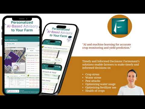
- Evaluates crop vigor and stress using NDVI, SAVI, GNDVI and other indices
- Identifies early signs of diseases or drought
- Supports zone-specific management – spatially adaptive treatments
-
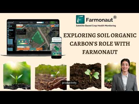
Soil Analysis & Fertilization Powered by Precision Satellite Imaging
Soil moisture monitoring and nutrient mapping are revolutionized using advanced hyperspectral imaging and machine learning models on satellite data. Detailed maps of organic matter content, moisture levels, and chemical signatures mean farmers can predict soil nutrient availability without the need for constant laboratory testing.
This enables precise fertilization—only applying inputs where needed and optimizing both cost and sustainability. Farmonaut integrates these insights directly into its carbon footprinting platform—helping organizations assess the environmental impact of soil and farm management practices.
- Assesses moisture, nutrient, and organic matter distribution across fields
- Enables precision nutrient management and targeted fertilization schedules
- Offers actionable insights on carbon footprint reduction via optimal soil health
-
Water Resource Management in Agriculture with Satellite Sensing
In water-scarce or drought-prone zones, efficient irrigation is crucial. Satellite-derived soil moisture measurements from missions like
SMAP deliver fine-grained data all year. This allows irrigation to be scheduled according to actual plant requirements, avoiding waste and boosting yield.Remote sensing in farming helps identify low-moisture zones, correlates water use with weather patterns, and monitors evapotranspiration—so every drop counts.
- Supports data-driven precision irrigation and allocation in smart farming
- Reduces water overuse and prevents drought stress in crops
- Links water management with microclimate data for yield optimization


-
Pest and Disease Detection: Early Action Through Hyperspectral Imaging Applications
Hyperspectral data from satellites enables early detection of pest infestations and diseases by capturing subtle biochemical changes invisible to traditional scouting. By analyzing spectral signatures and pigment changes in plant tissue, satellites flag problem areas before they cause substantial losses. This supports both:
- Reduction in pesticide use (only spray where and when needed)
- Minimizing crop losses via real-time monitoring and alerts
- Protecting ecosystem health by reducing chemical runoff
Within Farmonaut’s platform, real-time pest risk prediction and forest advisory extends these capabilities to small farms and large plantations alike.
-
Yield Prediction Using Satellites: Data-Driven Planning and Food Security
Leveraging time-series satellite imagery, advanced AI, and ground-truthing, modern platforms generate yield forecasts that inform harvest timing, capacity planning, and supply chain optimization. Satellite-based yield analysis helps governments, agribusinesses, and insurance providers anticipate:
- Expected production volumes (minimizing market shocks)
- Area-wise yield distribution for focused management
- Early warning of potential shortages or surpluses
Farmonaut also addresses this need with weather, crop, and historical analysis tools available via APIs for integration into digital agri-finance and insurance workflows. Explore the Farmonaut crop loan & insurance product for efficient access to crop risk assessment, satellite verification, and timely compensation.
-
Forest Management with Satellites: Safeguarding Biomass and Ecosystem Services
Forestry and land use management rely on satellite monitoring for:
- Tracking forest cover changes (deforestation/reforestation)
- Estimating total biomass and carbon sequestration
- Detection of illegal logging activities
Multitemporal analysis offers fast, unbiased reporting for global environmental management, policy-making, and sustainability certifications. Farmonaut’s crop plantation & forest advisory solutions support these missions—helping enterprises, governments, and NGOs enact better protection, restoration, and utilization of forest resources.

-
Resource Efficiency & Sustainable Land Management via Satellite-Based Analysis
Ultimately, satellite imaging empowers resource optimization across soil, water, fertilizer, and energy inputs. This means:
- Reduced input waste and environmental pollution
- Improved operational margins and ROI for all farm sizes
- Support for transparent supply chains—with blockchain-backed traceability of farm outputs
- Visibility into the sustainability of entire agricultural and forestry landscapes
Adopted globally, these precision agriculture technologies lay the foundation for long-term planetary health, food security, and economic prosperity.
“Precision farming using satellite data can increase crop yields by up to 20% through optimized soil moisture and nutrient management.”
Comparative Impact Table: Satellite Imaging and Yield Improvement
| Technique | Satellite Imaging Role | Estimated Yield Improvement (%) | Sustainability Contribution |
|---|---|---|---|
| Soil Moisture Monitoring | Detects real-time field moisture status for precision irrigation | 5–12% | Water use reduction, drought risk prevention |
| Crop Health Assessment (NDVI) | Analyzes plant vigor, stress, and disease risk for targeted interventions | 5–20% | Minimized fertilizer and pesticide runoff |
| Irrigation Management | Aligns fluid application with actual crop demand via evapotranspiration measurement | 6–15% | Water conservation & healthier soils |
| Pest Detection | Identifies early biophysical changes signifying pest or disease outbreak | 5–10% | Reduces pesticide application & safeguards biodiversity |
| Yield Prediction | Combines time-series images & AI for harvest and supply planning | 10–18% | Decreased food waste, better logistics |
| Land Management | Maps field boundaries, forests, and land use changes for compliance & resource planning | 5–12% | Prevents illegal land-use; supports restoration |
| Resource Efficiency | Optimizes input allocation across fertilizer, water, labor, and energy | 8–20% | Lower emissions; sustainable farm economics |
Farmonaut: Democratizing Precision Agriculture Technologies
At Farmonaut, we make satellite-based crop monitoring, soil moisture tracking, and AI decision-support accessible for every farmer and agricultural business—via the web, Android, and iOS app, as well as flexible API and developer documentation.
- Satellites For Every Scale: Whether smallholder or large enterprise, our platform delivers real-time imaging, NDVI, soil data, and expert advice at an affordable subscription rate.
- AI-Powered Jeevn Advisory System: Personalized, real-time recommendations (weather, irrigation, nutrition, pest alerts) based on your exact farm parameters, satellite data, and our robust AI models.
- Blockchain Traceability (Farm to Fork): Our traceability product uses blockchain to ensure reliable food/products origin, empowering sustainable, transparent supply chain management for brands and consumers alike.
- Fleet & Resources Management: For larger agribusinesses, our fleet management module facilitates field vehicle tracking, operational optimization, and improved profitability.
- Scalable, Mobile-First & API-Ready: Farmers, agribusinesses, and institutions can use Farmonaut’s platform anywhere, anytime, or plug our data into their own systems using APIs and admin tools for large-scale operations.
- Carbon Monitoring and Sustainability: Direct measurement of emissions and soil carbon with actionable plans for emission reduction and compliance, accessible via our carbon footprinting solution.
-
Subscription Pricing: Flexible packages for individuals, agribusinesses, or governments—pay per field or hectares monitored. See pricing:
Farmonaut Empowers All Agricultural Stakeholders:
- Farmers: Maximize their crop health monitoring, reduce resource waste, and secure higher yields by making data-driven field decisions.
- Agribusinesses: Manage plantations, labor, and logistics while monitoring vast fields affordably and at scale.
- Organizations & Government: Enable rapid crop area assessments, yield estimation, and monitor food security or disaster relief efficiently.
- Insurers & Banks: Use satellite-based risk verification (explore our crop loan and insurance page) to reduce fraud and improve rural finance offerings.
- Corporate & NGOs: Track supply chain sustainability and environmental impacts with ease (see traceability).
Frequently Asked Questions (FAQ)
How does satellite imagery for agriculture improve yields?
Satellite imagery delivers up-to-date spatial data—including vegetation health (using NDVI and similar indices), soil moisture, and pest/disease risk. This enables precision agriculture technologies and targeted management, often increasing yields by 10-20% or more with optimized water and nutrient use.
Can satellites really differentiate between crop types and soil nutrients?
Yes. Modern multispectral and hyperspectral satellites can classify crop types, assess plant vigor, and, when combined with machine learning, estimate soil nutrient levels, moisture, and even organic matter content with high spatial accuracy—minimizing the necessity for expensive, time-consuming laboratory sampling.
What is NDVI and why is it important in crop health monitoring?
NDVI (Normalized Difference Vegetation Index) is calculated from optical satellite imagery and measures the “greenness” and vitality of plants. It serves as an early warning system for stress, disease, or water deficiency—enabling proactive, zone-specific crop management.
How affordable is satellite-based monitoring for small farms?
Platforms like Farmonaut deliver affordable, pay-per-field access to satellite monitoring, AI advisory, and resource optimization. Small and medium farms can benefit from cutting-edge technology—without investing in expensive hardware—making modern precision agriculture practical for everyone.
What are the main challenges with satellite monitoring in agriculture?
Main challenges include cloud cover (limiting optical imaging), need for ground-truthing, data processing skills, and initial training for field staff. However, evolving AI tools, improved satellite revisits, and user-friendly platforms are rapidly lowering these barriers.
How can agricultural organizations access Farmonaut’s API?
Farmonaut’s satellite API and full developer documentation are available to integrate imaging, weather, and resource recommendations into custom apps, software, or enterprise systems for streamlined operations.
Challenges and Future of Remote Sensing in Agriculture
Despite dramatic improvements, satellite imagery for agriculture faces hurdles: data accessibility, cloud interference for optical satellites, local calibration, and the need for easy-to-use analytics remain priorities. Ongoing advancements in hyperspectral imaging, real-time processing, and AI-driven insights are making satellite-based solutions even more practical for everyday field operations.
- Smarter Sensing: Improved revisit rates and machine learning models will further automate crop monitoring and diagnostics.
- Democratized Access: Subscription apps, API integrations, and automated advisories—like those available from Farmonaut—will continue breaking technical and economic barriers.
- Environmental Impact: Linking sustainability, emissions, and compliance reporting with direct field data is set to become both an industry standard and a regulatory necessity.
- Policy and Global Food Security: As nations face growing population, climate change, and resource scarcity, satellite-powered decision making will underpin resilient, future-ready food systems and forest landscapes.
Conclusion: The Path to Precision, Productivity & Sustainability
Agricultural satellites have fundamentally redefined how farmers, agribusinesses, and policymakers approach crop management, soil moisture monitoring, resource allocation, and sustainability. Today, remote sensing in farming bridges the gap between traditional experience and modern scientific analysis—optimizing inputs, predicting risks, and safeguarding yields.
With the support of visionary platforms like Farmonaut, these space-age innovations are available to every field—empowering individuals, organizations, and nations to deliver more food, conserve resources, and protect our environment for the generations ahead.
Ready to unlock the next level in yield and sustainability? Start here.
Farmonaut is at the forefront in making precision farming logical, accessible, and scalable—from satellite-imaged crop health monitoring and AI-driven advice to full traceability and carbon compliance. Discover how we can help optimize your fields, protect your yields, and build a more sustainable agriculture—today.


