
Drone Survey Secrets: 7 Hacks to Revolutionize Land Management
“Over 70% of surveyed farmers plan to adopt drone surveys for land management by 2025.”

Table of Contents
- Introduction: Revolutionizing Land Management with Drones
- What is Drone Technology in Agriculture & Forestry?
- Benefits of Drone Surveys: Cost, Efficiency, & Sustainability
- Drone Survey Secrets: 7 Hacks to Revolutionize Land Management
- Comparative Table: Traditional vs. Drone-Based Land Management
- Farmonaut’s Role in Precision Agriculture & Land Management
- Challenges and Limitations of Drone Adoption
- The Future of Drone Integration: Trends and Innovations
- Frequently Asked Questions (FAQ)
Introduction: Revolutionizing Land Management with Drones
In today’s world, sustainable land management is no longer a luxury—it’s a necessity. As global challenges such as climate change, food security, and environmental degradation continue to intensify, drone technology in agriculture and forestry is delivering game-changing solutions. Unmanned aerial vehicles (UAVs)—more commonly known as drones—are at the forefront of this technological transformation. With their ability to provide real-time, precise data, they are optimizing the monitoring, assessment, and management of vast tracts of land.
Across the globe, more and more farmers and forest managers are turning to agricultural drone surveys to optimize resources, boost yields, and advance sustainable practices. In this comprehensive guide, we unveil the 7 most powerful hacks to revolutionize land management using drones, diving deep into the applications, benefits, challenges, and future of this breakthrough technology.
What is Drone Technology in Agriculture & Forestry?
Drones, or UAVs, are remote-controlled or autonomous aerial machines equipped with advanced technologies, including multispectral sensors, thermal cameras, GPS, and AI. In the context of agriculture and forestry, drones excel in aerial monitoring, field mapping, resource assessment, crop health evaluation and so much more.
By leveraging high-resolution aerial imagery and real-time data collection, these modern marvels allow us to:
- Visually inspect hundreds of hectares within minutes
- Analyze patterns in crop growth, soil conditions, and water levels
- Detect early signs of stress, disease, or pest infestations
- Map out forests, monitor wildlife, and manage conservation efforts
- Optimize agricultural input use, reducing costs and environmental impact
The integration of drone technology in agriculture makes precision farming with drones faster, smarter, and far more sustainable than ever before.
Benefits of Drone Surveys: Cost, Efficiency, & Sustainability
Why are progressive practitioners turning to drones for sustainable farming and forestry management? Let’s explore the standout benefits drones bring to land management—
- Cost-effectiveness: By automating surveys and monitoring, drones reduce the need for manual labor and expensive machinery.
- Efficiency: Drones can cover massive areas rapidly, enabling swift detection and resolution of issues—often in real-time.
- Precise Data Collection: Equipped with advanced sensors, drones produce highly accurate data, improving management decisions.
- Sustainability: By helping to optimize inputs and reduce waste, drone surveys promote more sustainable practices that benefit both crops and the environment.
- Enhanced Safety: Drones can access dangerous areas like steep forest slopes or flooded fields, reducing risk to workers.
Drone Survey Secrets: 7 Hacks to Revolutionize Land Management
Ready to unlock the true potential of drones for agricultural, farming, and forestry management? Here are seven powerful hacks you can implement for actionable, sustainable impact—
1. Crop Health Monitoring & Early Assessment with Multispectral Imaging Drones
One of the most impactful uses of drones in agriculture is crop health monitoring. By using multispectral imaging drones and thermal sensors, we can analyze plant vigor and detect:
- Disease outbreaks
- Pest infestations
- Nutrient deficiencies
- Moisture stress
This precise detection allows for targeted interventions—like focused pesticide or fertilizer applications—meaning we effectively reduce input costs and minimize environmental impact. Early warning systems based on drone data can help avoid crop loss and optimize yield.
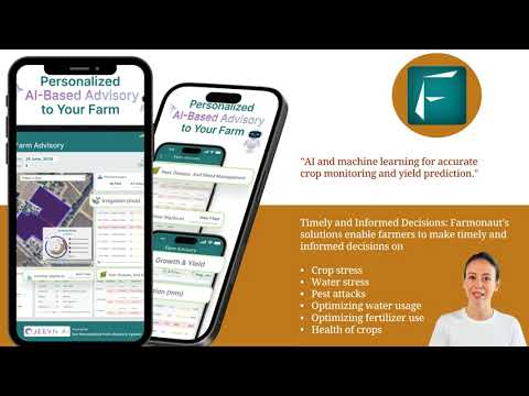
From identifying subtle color changes to measuring thermal anomalies, drones convert aerial field monitoring into a science. Farmonaut amplifies this approach using satellite imagery and AI-powered crop health monitoring—delivering immediate, actionable insights for every season.
Advantages:
- Swift detection of crop issues before they become severe
- Reduces overuse of pesticides and fertilizers
- Enables sustainable farming practices by minimizing environmental impact
2. Precision Irrigation: Conserve Water, Maximize Yields
Water is one of the most precious and costly resources in agriculture. Through analyzing aerial imagery collected with drones, we can:
- Identify moisture variations across fields
- Pinpoint areas requiring more or less water
- Enable precision irrigation systems
This approach not only conserves water but also ensures every plant receives optimal hydration. For large and small farms alike, accurate moisture assessment increases efficiency and yields while dramatically lowering wastage.
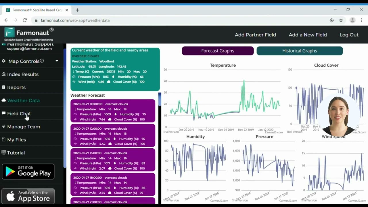
Farmonaut also features soil moisture analysis using multispectral satellite data. By combining in-app drone data with real-time satellite updates, farmers can fine-tune irrigation and avoid costly water stress.
Key Benefits:
- Reduce water usage by up to 30%
- Better soil health and structure
- Boosted productivity, especially in regions facing drought

3. Drone-Based Soil Analysis and Aerial Mapping for Agriculture
Understanding soil variability is fundamental for sustainable farming. Through drone-based soil analysis and aerial mapping for agriculture, we can create detailed maps showing:
- Soil type variations
- Nutrient content and deficiencies
- pH levels
- Drainage and compaction
Such intelligence allows the precise positioning of fertilizers, the selection of suitable crops, and improved field management strategies. Farmonaut’s satellite-powered platform also delivers large-scale farm management solutions, helping plan sowing, fertilization, and crop rotation schedules for optimal land productivity.
Optimize With:
- Custom fertilization plans
- Soil health monitoring over time
- Yield prediction and input cost reduction
4. Livestock Monitoring & Welfare Enhancement
In modern farming, animal welfare is as important as crop health. Drones equipped with thermal cameras are used to monitor herds, detect signs of distress or illness, and prevent loss from predation or escape. By surveying large agricultural fields and paddocks efficiently, drones can:
- Spot isolated or ill animals quickly
- Monitor calving, lambing, or foaling cycles
- Track movements to prevent theft or predation
This targeted approach enables timely medical intervention and improves overall herd management without costly manual labor.
“Drone mapping can cover up to 1,000 acres per day, 10 times faster than traditional land surveys.”
5. Advanced Field Mapping & Large-Scale Agricultural Surveying
Conventional field surveying is labor-intensive, slow, and often inaccurate. Drones equipped with GPS, multispectral, and thermal sensors can:
- Create accurate field maps in minutes
- Assist with crop planning, planting patterns, and optimal harvest timing
- Map large or complex terrains with ease
Our ability to analyze data from drone-based field mapping allows for rapid decision-making and adaptability in dynamic climates.
We can seamlessly scale this capability with large-scale farm management tools, enabling organizations to handle plantation, harvesting, and resource deployment efficiently.
6. Forestry Applications: Drones for Sustainable Forest Management
Forests demand constant monitoring to safeguard their vitality and biodiversity. Drones provide:
- Forest inventory & mapping: Capturing high-res images to assess canopy density, species distribution, and tree height
- Monitoring forest health: Detecting diseases, pest infestations, or illegal activity swiftly
- Surveying inaccessible terrain: Reducing risk and operational costs for field staff
With carbon footprinting tools, we can measure and manage the environmental impact of forestry operations, advancing sustainable practices and regulatory compliance.

7. Conservation, Fire Detection, and Wildlife Monitoring with Drones
The applications of drones for forest conservation and wildlife monitoring are steadily expanding. By providing real-time imagery and heat signatures, drones:
- Enhance biodiversity monitoring
- Support early wildfire detection and response
- Track endangered species without disturbing habitats
Combined with satellite data, AI, and blockchain, drones play a crucial role in supply chain traceability and transparent, ethical land use. Farmonaut’s blockchain solutions ensure authenticity from farm or forest to end consumer, reducing fraud and promoting sustainability.
Comparative Table: Traditional vs. Drone-Based Land Management
| Land Management Activity | Traditional Method (Estimated Data) | Drone Survey Method (Estimated Data) | Improvement (%) |
|---|---|---|---|
| Crop Health Monitoring Frequency | Once per season (visual check) | Weekly or real-time (multispectral imaging drones) | +400% |
| Survey Coverage Area (hectares/day) | 10 (manual survey) | 100-1,000 (drone mapping) | +9000% |
| Data Accuracy (%) | 60-70% | 95-99% (precise sensors) | +40% |
| Labor Costs (USD/hectare) | $15-$25 | $3-$5 | -80% |
| Time to Generate Reports (days) | 5-10 | 1 (instantaneous possible) | -90% |
| Environmental Impact (Carbon Emissions kg/ha) | 1.5-2.0 | 0.3-0.5 | -75% |
Farmonaut’s Role in Precision Agriculture & Land Management
While drone surveys are transforming how we approach land management, effective action hinges on actionable, accessible data. That’s where Farmonaut drives a true revolution.
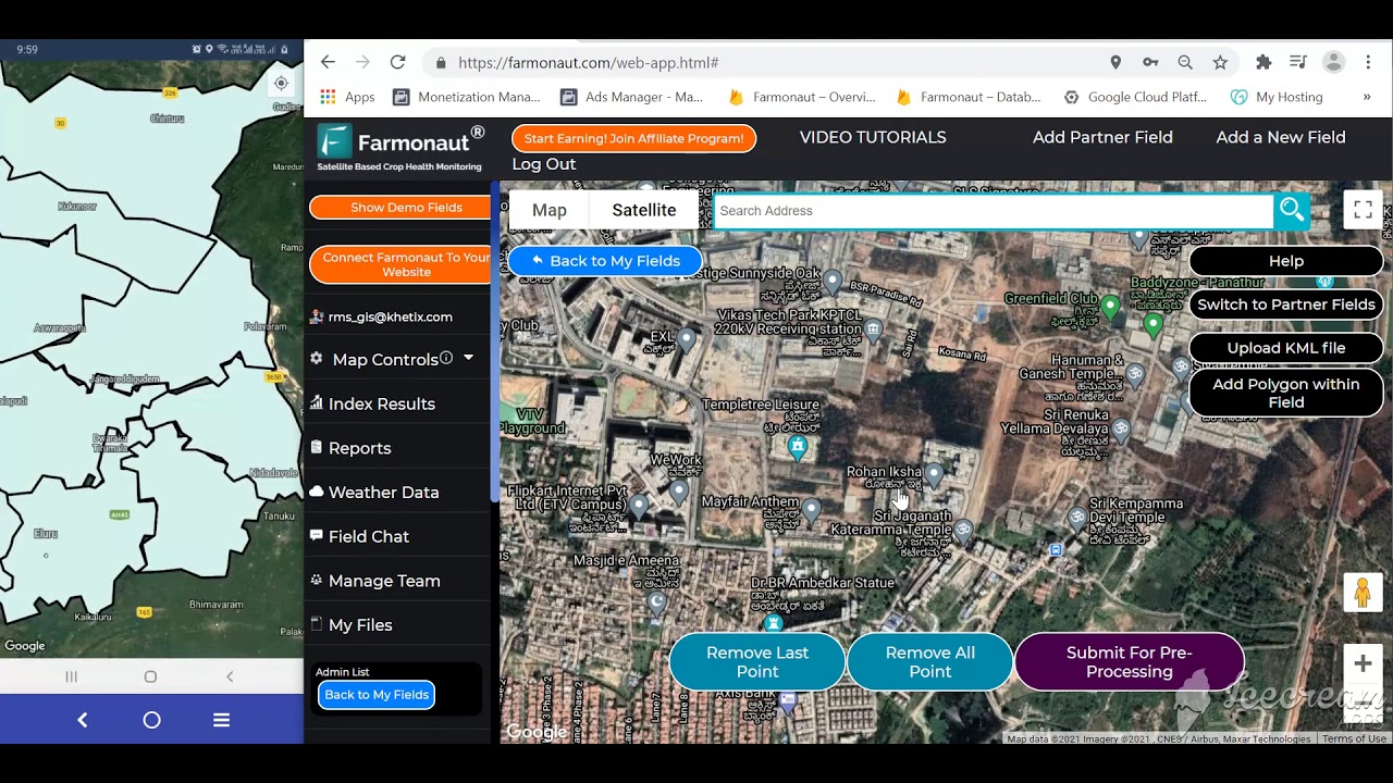
Farmonaut is a global leader in satellite-powered farm management solutions accessed via Android, iOS, Web App, and API. Unlike niche drone-only providers, Farmonaut’s technology synthesizes:
- Multispectral satellite imagery
- AI-powered crop health monitoring and Jeevn AI Advisory
- Carbon footprinting and climate compliance tools
- Blockchain-based traceability solutions for product authentication
- Fleet and resource management for equipment and field operations
Our mission: to make precision agriculture affordable and accessible to farmers worldwide. We bridge the gap between drone-generated, satellite-based, and AI-interpreted data, allowing everyone from smallholders to large agribusinesses, governments, and researchers to optimize, monitor, assess, and sustainably manage land—all via user-friendly apps and APIs.
- Our large-scale farm management platform empowers agribusinesses and cooperatives to supervise plantations, perform field mapping, and plan logistics efficiently.
- With carbon footprinting tools, we help you measure and reduce land-use emissions for sustainable farming and regulatory compliance.
- Our product traceability system leverages blockchain, offering transparent, fraud-resistant supply chains for food, textiles, and more.
- Crop loan and insurance verification tools streamline agricultural finance, bringing support to where it’s needed most.
- Resource optimization features support fleet management and logistics for cost-efficient equipment use and safer agricultural transport.
Farmonaut Subscription Plans
Challenges and Limitations of Drone Adoption
While the advantages of drone-based land management are immense, there are challenges to navigate:
- Regulatory Constraints: Regulations can restrict drone flight zones, require expensive licenses, or limit maximum altitude. These vary by country and locality and impact adoption.
- Technological Limitations: Drones are affected by battery range, payload capacity, weather conditions, and connectivity in remote regions.
- Data Management: The collection of high-volume, high-resolution images requires robust storage and skilled analysis capabilities—not always available on small or medium farms.
- High Initial Costs: While operational costs are generally lower, purchasing drones and equipment is a hurdle—though satellite-based systems like Farmonaut offer highly cost-effective alternatives for many.
- Privacy Concerns: Drones can inadvertently capture private property images or sensitive data, raising privacy and ethical matters within communities.
We must balance the benefits of data-driven land management with robust security, compliance, and user education efforts. The integration of drone, satellite, and AI intelligence—such as on the Farmonaut platform—makes these technologies even more accessible, affordable, and privacy-aware.
The Future of Drone Integration: Trends and Innovations
The next decade of agro-forestry management will feature multi-layer intelligence, where drone technology in agriculture and forestry is tightly interwoven with AI, IoT, and blockchain for seamless, autonomous land management.
Key future advancements to watch:
- Advanced Sensors: High-resolution thermal and multispectral imaging drones for ultra-precise monitoring
- Full AI Autonomy: AI not just analyzes data, but also recommends and sometimes implements corrective action
- Regulatory Evolution: More standardized, adaptive regulations as drones become mainstream
- Converged Technologies: Unified satellite, drone, and sensor data, analyzed on platforms like Farmonaut, for a “single source of truth” on land conditions, resource allocation, and risk
- Wider Access: Subscription platforms and APIs are making precision agriculture and forestry accessible from small farms to large government projects globally
By embracing drone surveys and integrating with next-gen platforms like Farmonaut, we position ourselves at the cutting edge of sustainable farming and forest management.
Frequently Asked Questions (FAQ)
How do drones help in crop health monitoring?
Drones use high-resolution cameras and multispectral imaging sensors to detect variations in crop color and temperature, enabling early detection of diseases, pest infestations, and nutrient deficiencies. This supports targeted, timely interventions, reducing costs and environmental impact.
Are drone surveys affordable for small and medium-sized farms?
Initial equipment costs can be high, but operational savings and yield improvements offset the investment. Farmonaut’s satellite-based crop monitoring and flexible subscription plans offer affordable precision farming tools for farms of all sizes.
What are the main challenges for drone adoption in agriculture and forestry?
Regulatory constraints, high initial equipment costs, short battery life, and data management demands are common. Privacy concerns must also be addressed through responsible flight planning and secure data handling.
Can drones help with water management in agriculture?
Yes! Drones analyze aerial and thermal imagery to assess field moisture levels, helping farmers implement precision irrigation. This reduces water wastage and supports optimized, sustainable farm production.
How does Farmonaut’s platform enhance traditional drone survey data?
Farmonaut integrates satellite-backed crop, soil, and resource analytics with AI-powered advisories, blockchain-based traceability, and resource management features—all accessible via web, mobile, and API for truly scalable land management.
Are there privacy risks with drones?
Drones can inadvertently capture images of private property. It’s crucial for operators to comply with regulations, respect community privacy, and secure collected data appropriately.
Where can I learn more or get started with Farmonaut?
Visit Farmonaut’s app platform,
explore the API, or visit our developer docs. Start leveraging precision farming and sustainable management now!
Conclusion: Empowering the Next Generation of Land Stewards
The integration of drone technology in agriculture and forestry is reshaping how we monitor, manage, and care for our land. By leveraging precise, real-time data from aerial and satellite drones, we can make informed decisions, optimize resource allocation, and promote sustainable practices—all while boosting yields, conserving resources, and safeguarding the environment.
With platforms like Farmonaut at our disposal, we democratize access to advanced monitoring, AI-powered advisories, and secure supply chains. The future of land management is here—sustainable, scalable, and powered by innovation. The only question is: Are we ready to take flight and transform our fields, forests, and futures?


Ready to revolutionize your land management strategy?
Start with Farmonaut’s precision agriculture solutions and unlock the full power of drones, satellite, and AI for a productive and sustainable future!


