
Satellite Images of Agricultural Land: 7 Key Insights
Meta Description: Satellite imagery for agriculture provides detailed data, empowering crop health monitoring, soil moisture mapping, and sustainable yield through precision farming techniques. Uncover the 7 key insights driving modern agricultural management.
“Over 80% of precision farming operations now utilize satellite imagery for real-time crop health monitoring worldwide.”
Introduction
In the rapidly evolving world of agriculture, our access to data-driven insights is revolutionizing the way we approach every aspect of crop and soil management. Satellite imagery for agriculture stands at the heart of this transformation, providing farmers and researchers with previously unimaginable detail about their land, resources, and crops.
From real-time crop health monitoring and soil moisture mapping to responding rapidly to environmental and climatic changes, satellite images now enable precision farming techniques that are both efficient and sustainable. As we delve deeper in this comprehensive guide, we’ll uncover the 7 key insights made possible by the advancements in satellite technology and their impact on modern agriculture.


Advancements in Satellite Technology for Agriculture
The development of modern Earth observation satellites has fundamentally redefined what’s possible for agricultural management and environmental monitoring in farming. Missions like the European Space Agency’s Sentinel-2 provide high-resolution multispectral imaging capabilities, capturing imagery across 13 spectral bands including visible, near-infrared, and short-wave infrared. This spectral coverage (with resolutions from 10–60 meters) enables detailed assessment of vegetation, soil, and land cover changes at a scale never before available.
Equipped with this powerful technology, we now have access to:
- Comprehensive monitoring of crops and soil
- Analysis of vegetation indices for crop assessment (such as NDVI)
- Detection of land cover change for efficient environmental management
- Soil moisture mapping, enabling precision farming techniques

These capabilities are not just for large farms or research institutions. Platforms like Farmonaut have made precision agriculture not only affordable but also accessible to farmers worldwide through mobile apps and APIs. Now, every field, regardless of its size, can benefit from real-time crop assessment, soil health evaluation, and efficient resource management.

The Power of Multispectral and Hyperspectral Imaging
Thanks to satellite imagery for agriculture, we’re able to:
- Monitor crop health and detect early signs of stress
- Understand precise soil moisture conditions to guide precision irrigation
- Assess changes in vegetative cover and monitor environmental conditions
- Integrate data into Geographic Information Systems (GIS) for robust decision-making
“Satellite data can detect soil moisture variations with up to 90% accuracy, revolutionizing sustainable yield management.”

Satellite Imagery for Agriculture: 7 Key Insights
Let’s explore the seven critical ways satellite imaging is reshaping the landscape of agriculture:
1. Crop Health Monitoring
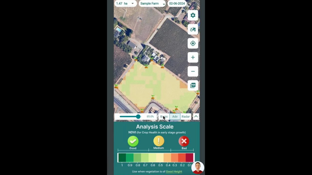
Modern crop health monitoring relies on analyzing vegetation indices, especially the Normalized Difference Vegetation Index (NDVI). NDVI, calculated from the visible and near-infrared bands, ranges from -1 to 1, with higher NDVI values indicating healthier, more robust vegetation.
By leveraging satellite imagery for agriculture, farmers gain early insights into:
- Water scarcity or irrigation issues
- Nutrient deficiencies
- Pest and disease outbreaks
- Physical crop damage after severe weather
These early indicators allow for timely interventions and mitigating potential yield losses. For example, a sudden drop in NDVI across a particular region, visible via satellite monitoring, signals that immediate action—like additional watering or nutrient application—may be necessary.
- NDVI and other vegetation indices for crop assessment are foundational to precision farming techniques.
2. Precision Irrigation and Water Resource Management
Effective water management is crucial for sustainable yield. Soil moisture mapping via satellites like NASA’s SMAP helps us identify areas with insufficient or excessive moisture, guiding farmers to apply water only where and when needed. This approach:
- Prevents over-irrigation and reduces waste
- Promotes optimal crop growth
- Mitigates risk of soil erosion and nutrient leaching
- Contributes to sustainable agriculture practices
Integration with GIS tools further refines the process, allowing for sector-wise or even row-wise application of irrigation.
- Discover how this works with Farmonaut’s precision agriculture solutions.
3. Nutrient Management and Soil Health
Maintaining soil fertility is essential for maximizing yields while ensuring sustainability. Satellite imagery can:
- Detect variations in crop vigor—indicating nutrient imbalances
- Track soil condition changes over time
- Support targeted fertilizer application, reducing environmental impact
Combining satellite-derived data with ground-based soil test results enables farmers to decide exactly where, when, and how much to apply key nutrients—significantly enhancing both productivity and ecological responsibility.
- Explore more about sustainable nutrient management through Farmonaut’s Carbon Footprinting solutions, which track fertilizer impacts and support climate-smart agriculture.
4. Pest and Disease Management with Early Detection
One of the most significant breakthroughs in environmental monitoring in farming is proactive pest and disease management. Hyperspectral satellite data can reveal even the most subtle changes in plant reflectance, often before visible damage appears.
By identifying early signs of stress due to pests or diseases, farmers can implement targeted interventions:
- Apply pesticides/fungicides precisely, minimizing chemical use
- Promote environmentally responsible farming practices
- Reduce crop losses through rapid response
This not only safeguards crop health but also aligns with sustainable agriculture practices and market standards for traceability.
- Interested in supply chain transparency? Explore Farmonaut Traceability Platform for improved safety and compliance.
5. Yield Forecasting and Harvest Optimization
Harnessing satellite imagery and historical farm data gives us the power to predict yield forecasting in agriculture with greater accuracy. Integrating weather forecasts, historical crop patterns, and real-time updates, agricultural resource management becomes proactive rather than reactive.
Key Benefits:
- Optimize harvest timing for peak quality
- Refine storage and logistics planning
- Improve market strategies with timely, data-driven decisions
- Secure accurate claims for insurance
- For satellite-based crop loan verification and insurance assessment, visit Farmonaut Crop Loans & Insurance Verification.

6. Land Cover Change Detection & Soil Moisture Monitoring
Monitoring land cover changes via sentinel satellites and soil moisture mapping with missions like SMAP enables fine-tuned environmental management and conservation.
Key Applications:
- Detect deforestation, desertification, or erosion in real time
- Match soil moisture status to optimal crop selection
- Support water retention and flood control measures
- Advanced large-scale field oversight is possible using Farmonaut’s Large-Scale Farm Management platform.
7. Sustainable Agriculture Practices & Resource Management
Driven by global demands for environmental sustainability, satellite imagery now helps us pursue sustainable agriculture practices through:
- Precise tracking of resource inputs (water, fertilizers, crop protection chemicals, and energy)
- Measuring carbon footprints with geospatial accuracy
- Supporting regulatory compliance and access to eco-certifications
- Effective multi-vehicle and team logistics for plantation and advisory programs can be enhanced with Farmonaut’s Fleet Management Tools.
Feature Comparison Table of Satellite Imagery Applications in Agriculture
To visualize the unique value of each satellite-enabled insight, here’s a comprehensive comparison table:
| Insight | Description | Satellite Technology Used | Estimated Accuracy (%) | Benefits to Farmers |
|---|---|---|---|---|
| Crop Health Monitoring | Assessment of vegetation health using indices (NDVI, EVI) to detect stress, deficiencies, and damage. | Multispectral Imaging, NDVI | 85–90% | Early detection of issues, timely interventions, optimize yields. |
| Soil Mapping/Moisture | Soil moisture mapping, fertility, and structure assessment. | SAR, SMAP, Multispectral | 80–90% | Efficient irrigation, conserve water, boost root health. |
| Water Stress Detection | Pinpointing areas suffering from drought or overwatering. | Thermal, Multispectral | 70–85% | Target water management, prevent nutrient leaching. |
| Pest/Disease Forecasting | Early signs of pathogens or pest attack via canopy changes. | Hyperspectral, Multispectral | 75–85% | Reduce losses, lower chemical usage, more eco-friendly. |
| Yield Estimation | Forecasting harvest output using crop and weather data. | Multispectral, AI-modelling | 80–90% | Plan market sales, reduce waste, improve logistics. |
| Field Boundary Mapping | Accurate plotting of farm/field borders. | Optical, SAR, GIS overlays | 85-90% | Reduce disputes, streamline administration/loans. |
| Sustainable Practices | Tracking input use, emission, and compliance for sustainable farming. | Multispectral, Carbon Footprint Sensors | 80–85% | Meet eco-standards, reduce costs, improve market access. |
Global Impact of Satellite Imagery in Agriculture and Future Directions
Satellite-enabled precision farming techniques have taken root across the globe. As highlighted in recent studies, the integration of satellite data in India led to increased profits and yields for countless farmers, with net profits per acre rising substantially. The global space agriculture market is projected to reach $11.5 billion by 2032 (Reuters).
Key Ongoing Challenges
- Data Accessibility: The need for affordable, high-frequency, and high-resolution data across all regions and farm sizes.
- Technical Skills: Empowering more farmers with training and intuitive tools to interpret satellite data.
- System Integration: Seamless merging of satellite imagery with existing farm management systems and mobile apps.
The Future: AI and Machine Learning in Satellite-Based Agriculture
The next generation of AI-driven decision support systems is already underway. By applying machine learning to vast archives of Earth observation imagery, we can:
- Predict soil carbon levels and environmental trends
- Automate detection of crop stress and diseases
- Optimize every aspect of resource management
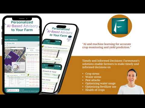
- Farmonaut incorporates AI-powered advisory systems and satellite data into its platform to maximize these advancements for farms and agribusinesses worldwide.
Farmonaut Satellite & Weather API |
API Developer Documentation
Farmonaut’s Contribution to Precision Farming
As a leading provider of satellite-based farm management solutions, we at Farmonaut are committed to making precision agriculture more affordable and accessible. Our offerings are designed to integrate innovative technology and data-driven insights into traditional farming practices, powering transitions to sustainable agriculture models.
-
Satellite-Based Crop Health Monitoring: We enable
real-time crop health monitoring, soil moisture assessment, and actionable field insights using multispectral and hyperspectral imagery. -
AI-driven Jeevn Advisory: Personalized recommendations—advising on planting, harvesting, fertilization, and irrigation—are generated from
live or historical data to improve
farm productivity. -
Blockchain Traceability: From farm-to-market, supply chains are authenticated and product origins are recorded securely, minimizing fraud and enhancing
consumer trust. -
Fleet & Resource Management: Our solutions ensure
efficient logistics
for large-scale operations and contract plantations. -
Carbon Footprinting: Real-time estimates of emissions to help businesses and
farmers meet sustainability targets.
Access is universal through our
Android, iOS, Web App,
and broad integration is available via
APIs
for agribusiness, fintech, and research partners.
How Farmonaut Empowers All Stakeholders
- Farmers: Receive actionable crop and soil insights on their mobile—monitor, diagnose, irrigate, and optimize from anywhere.
- Agribusinesses: Manage plantations, fleets, and contracts efficiently across large geographies with geospatial insights.
- Government & NGOs: Power grant schemes, subsidies, crop areal surveys, and sustainability tracking.
-
Corporate Clients: Enable
blockchain traceability
for food/textile supply chains. - Financial Institutions: Automate loan/insurance verification with satellite-based farm observation.
Farmonaut Subscriptions
We offer scalable, subscription-based pricing built for individual farmers, cooperatives, businesses, and government institutions—pay for the number of hectares and satellite update frequency you need. Get started via our
Android, iOS, or Web App
or API for advanced integrations.
Frequently Asked Questions
What is satellite imagery for agriculture?
Satellite imagery for agriculture involves capturing and analyzing multispectral and hyperspectral images of agricultural land from space to monitor crop health, soil moisture, land cover changes, and more. It enables precision farming, better resource management, and sustainable agricultural practices.
How does NDVI help with crop health monitoring?
NDVI (Normalized Difference Vegetation Index) leverages visible and near-infrared satellite bands to assess the vigor of plant growth. High NDVI values typically indicate healthy vegetation, while sudden drops suggest issues like water stress or disease, enabling timely interventions.
How accurate is satellite-based soil moisture mapping?
Soil moisture mapping using satellites like SMAP and SAR can detect variations with up to 90% accuracy, helping optimize irrigation and predict water-related crop issues.
What are some sustainable agriculture practices supported by satellite imagery?
Satellite imagery supports sustainable agriculture by enabling resource optimization (water, inputs), soil health monitoring, tracking carbon emissions (carbon footprinting), and helping with traceability for supply chain transparency.
Who can use Farmonaut’s solutions?
Our platforms are designed for farmers, agribusinesses, government organizations, financial institutions, and corporate clients in the food and textile industries. Solutions are accessible on web, Android, and iOS for maximum coverage and convenience.
Conclusion
The evolution of satellite imagery for agriculture has fundamentally shifted global farming towards a more data-driven, sustainable, and productive era.
With tools like NDVI for crop health monitoring, soil moisture mapping, and land cover change detection, farmers and decision-makers are equipped to enhance yields, reduce resource waste, and ensure long-term environmental sustainability.
The integration of AI is set to further amplify the value of Earth observation in agricultural resource management, making every farm more resilient and future-ready.
Platforms like Farmonaut are leading the way by making precision farming techniques practical, affordable, and accessible—empowering the next generation of global agriculture.
Ready for smarter, more sustainable farming? Download the Farmonaut App or integrate our API today.


