
Revolutionizing Forest Conservation: Farmonaut’s Satellite Tech Safeguards 350 Acres in Austria and Czechia
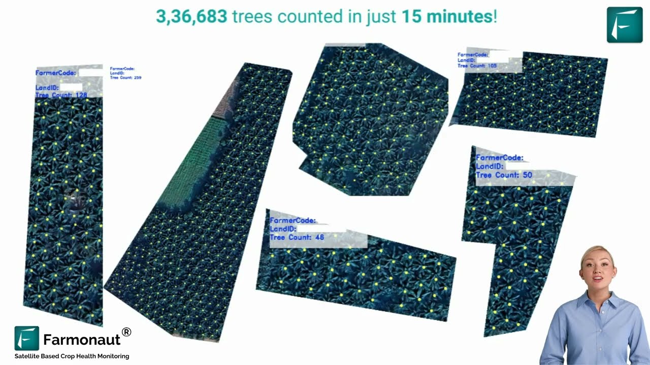
“Farmonaut’s satellite tech surveyed over 350 acres of forests in Austria and Czechia for precise tree count analysis.”
In an era where environmental protection has become paramount, we at Farmonaut are proud to be at the forefront of innovative forest conservation technology. Our recent groundbreaking initiative in Austria and Czechia showcases the power of advanced satellite analytics in safeguarding our planet’s vital ecosystems. By surveying over 350 acres of forests across these two countries, we’ve demonstrated how cutting-edge technology can revolutionize our approach to forest management and conservation efforts.

The Power of Satellite Imagery in Forest Monitoring
At the heart of our project lies the utilization of state-of-the-art satellite imagery for forest monitoring. This technology allows us to capture detailed, high-resolution images of vast forest areas, providing an unprecedented view of these complex ecosystems. Here’s how our satellite-based approach is making a difference:
- Precise Tree Count Analysis: Our advanced algorithms can identify and count individual trees, giving us an accurate representation of forest density and coverage.
- Vegetation Health Assessment: By analyzing spectral data, we can evaluate the overall health of the forest, identifying areas of stress or disease.
- Historical Deforestation Patterns: Comparing current imagery with historical data allows us to track changes over time and identify areas at risk of deforestation.
This level of detail and accuracy was previously unattainable with traditional forest survey methods. By leveraging satellite technology, we’re able to cover vast areas quickly and efficiently, without the need for extensive on-ground resources.
NDVI and EVI: Key Indicators of Forest Health
“Using NDVI and EVI indices, Farmonaut’s project evaluates ecosystem vitality across hundreds of acres of European forests.”
In our quest to provide comprehensive forest health assessments, we employ two crucial vegetation indices: the Normalized Difference Vegetation Index (NDVI) and the Enhanced Vegetation Index (EVI). These indices are instrumental in our forest conservation technology toolkit.
Understanding NDVI
The Normalized Difference Vegetation Index (NDVI) is a standardized way to measure healthy vegetation. It’s based on the principle that healthy vegetation absorbs most visible light and reflects a large portion of near-infrared light. Here’s how we use NDVI in our forest health assessment:
- NDVI values range from -1 to +1, with higher values indicating denser, healthier vegetation.
- We analyze NDVI patterns across the surveyed areas to identify regions of robust forest growth and areas that might be under stress.
- By tracking NDVI over time, we can detect seasonal changes and long-term trends in forest health.
The Role of EVI
The Enhanced Vegetation Index (EVI) is an optimized version of NDVI that provides additional sensitivity in high biomass regions. This makes it particularly useful for our work in dense forest areas. Here’s why EVI is crucial for our forest conservation efforts:
- EVI can better distinguish canopy variations in areas where NDVI might saturate.
- It’s less sensitive to atmospheric conditions, providing more reliable data in varying weather conditions.
- We use EVI to complement NDVI data, giving us a more comprehensive picture of forest ecosystem vitality.

Advanced Tree Count Analysis: The Foundation of Forest Management
One of the cornerstones of our forest conservation technology is our advanced tree count analysis. This innovative approach allows us to accurately assess forest density and structure, providing crucial data for sustainable forest management. Here’s how our tree count analysis works:
- High-Resolution Imagery: We use ultra-high-resolution satellite images to capture detailed views of forest canopies.
- AI-Powered Detection: Our proprietary algorithms use machine learning to identify individual trees from satellite imagery.
- Spatial Analysis: We map the distribution of trees across the surveyed area, providing insights into forest structure and biodiversity.
This level of detail in tree count analysis is revolutionizing how we approach forest conservation. It allows for more targeted interventions and better-informed decision-making in forest management strategies.
Deforestation Risk Analysis: Proactive Conservation
A critical component of our forest conservation efforts is deforestation risk analysis. By studying historical patterns and current forest health indicators, we can identify areas that are most vulnerable to future deforestation. This proactive approach allows for timely interventions and more effective conservation strategies.
Key Aspects of Our Deforestation Risk Analysis:
- Historical Data Analysis: We examine satellite imagery over extended periods to identify long-term trends in forest cover changes.
- Proximity to Human Activity: Areas close to expanding urban centers or agricultural lands are often at higher risk of deforestation.
- Forest Fragmentation Assessment: We analyze the continuity of forest cover, as fragmented forests are more susceptible to further degradation.
- Climate and Topography Considerations: Certain climate conditions and topographical features can make forests more vulnerable to deforestation.
By integrating these factors, we create comprehensive risk maps that highlight areas requiring immediate attention and long-term monitoring. This data-driven approach enables stakeholders to allocate resources more effectively and implement targeted conservation measures.
Sustainable Forest Management: A Data-Driven Approach
At Farmonaut, we believe that sustainable forest management is key to long-term conservation success. Our satellite analytics provide the foundation for data-driven decision-making in forest management practices. Here’s how our technology supports sustainable forest management:
- Resource Allocation: By identifying areas of high conservation value or those at risk, we help stakeholders prioritize their efforts and resources.
- Monitoring of Conservation Efforts: Our continuous satellite monitoring allows for real-time assessment of the impact of conservation initiatives.
- Biodiversity Preservation: Through detailed forest structure analysis, we can identify habitats crucial for biodiversity conservation.
- Carbon Stock Estimation: Our advanced analytics contribute to more accurate estimates of forest carbon stocks, supporting climate change mitigation efforts.
This data-centric approach to forest management ensures that conservation efforts are not only more effective but also more sustainable in the long run.

Conservation Efforts in Austria and Czechia: A Comparative Analysis
Our project in Austria and Czechia provides a unique opportunity to compare forest conservation efforts in two neighboring countries with distinct forest ecosystems. This comparative analysis not only showcases the versatility of our satellite analytics but also highlights the importance of tailored conservation strategies for different regions.
| Metrics | Austria | Czechia |
|---|---|---|
| Total Acres Surveyed | 180 | 170 |
| Estimated Tree Count | 285,000 | 260,000 |
| Average NDVI Score | 0.78 | 0.75 |
| Average EVI Score | 0.65 | 0.62 |
| Historical Deforestation Rate (%) | 0.3% | 0.4% |
| At-Risk Areas Identified | 15 | 18 |
This comparative analysis reveals subtle but significant differences in forest health and conservation challenges between Austria and Czechia. Such insights are invaluable for developing targeted, region-specific conservation strategies.
Environmental Protection Initiatives: From Data to Action
The wealth of data provided by our satellite analytics forms the foundation for a range of environmental protection initiatives. Here’s how our technology is driving concrete action in forest conservation:
- Policy Formulation: Our data informs policymakers, helping them create more effective forest protection laws and regulations.
- Conservation Planning: Detailed forest health maps enable conservationists to design more targeted and effective protection strategies.
- Public Awareness: Visualizations created from our satellite data help in raising public awareness about the importance of forest conservation.
- Research Support: Our comprehensive datasets contribute to academic research in forestry and ecology, furthering our understanding of forest ecosystems.
By bridging the gap between data collection and action, we’re helping to create a more sustainable future for our forests.
The Future of Forest Conservation: Precision Forestry and Green Tech
As we look to the future, we at Farmonaut are excited about the potential of precision forestry and green tech in revolutionizing forest conservation. Our work in Austria and Czechia is just the beginning of what’s possible with advanced satellite analytics and AI-driven forest management.
Emerging Trends in Precision Forestry:
- AI and Machine Learning: Advanced algorithms will enable even more accurate tree species identification and health assessment from satellite imagery.
- IoT Integration: Combining satellite data with ground-based sensors will provide real-time, hyper-local forest monitoring capabilities.
- Predictive Analytics: By analyzing historical data and current trends, we’ll be able to predict and prevent potential forest health issues before they become critical.
- Virtual and Augmented Reality: These technologies will offer new ways to visualize and interact with forest data, enhancing decision-making processes.
The integration of these technologies with our existing satellite analytics platform will usher in a new era of forest conservation, where data-driven decisions and real-time monitoring become the norm.
Empowering Stakeholders with Satellite Analytics
One of the most impactful aspects of our work is how it empowers various stakeholders in the forest conservation ecosystem. From government agencies to local communities, our satellite analytics provide valuable insights that drive informed decision-making.
How Different Stakeholders Benefit:
- Government Agencies: Our data supports policy formulation and helps in monitoring the effectiveness of conservation programs.
- NGOs and Conservation Groups: Detailed forest health maps enable more targeted and efficient conservation efforts.
- Research Institutions: Our comprehensive datasets contribute to advancing scientific understanding of forest ecosystems.
- Local Communities: By providing insights into local forest health, we help communities better manage their natural resources.
By democratizing access to advanced forest monitoring tools, we’re fostering a collaborative approach to forest conservation that involves all stakeholders.
Innovative Forest Survey Techniques: Beyond Traditional Methods
Our work in Austria and Czechia showcases how innovative forest survey techniques are transforming the field of forest conservation. These methods go far beyond traditional, ground-based surveys, offering unprecedented scale, accuracy, and efficiency.
Key Innovations in Our Forest Survey Techniques:
- Multi-Spectral Imaging: By capturing data across multiple spectral bands, we can detect subtle changes in forest health that are invisible to the naked eye.
- Time Series Analysis: Regular satellite passes allow us to create time-lapse views of forest changes, revealing trends and patterns over months and years.
- 3D Forest Mapping: Advanced techniques like LiDAR integration enable us to create detailed 3D models of forest structures, providing insights into canopy height, biomass, and carbon storage.
- Automated Change Detection: Our AI algorithms can quickly identify and flag changes in forest cover, allowing for rapid response to potential threats.
These innovative techniques not only improve the accuracy and comprehensiveness of forest surveys but also make it possible to monitor vast areas of forest with unprecedented frequency and detail.
The Role of Environmental Technology in Addressing Global Challenges
Our forest conservation project in Austria and Czechia is part of a broader movement leveraging environmental technology to address global challenges. As climate change and biodiversity loss become increasingly urgent issues, the role of technologies like ours becomes ever more critical.
Key Areas Where Environmental Technology is Making a Difference:
- Climate Change Mitigation: By providing accurate data on forest carbon stocks, we’re supporting global efforts to reduce greenhouse gas emissions.
- Biodiversity Conservation: Our detailed forest mapping helps in identifying and protecting critical habitats for endangered species.
- Sustainable Resource Management: Our technology supports the sustainable use of forest resources, balancing economic needs with conservation imperatives.
- Disaster Risk Reduction: By monitoring forest health and identifying at-risk areas, we’re contributing to efforts to prevent and mitigate natural disasters like wildfires and landslides.
As we continue to develop and refine our environmental technology, we’re excited about its potential to drive positive change on a global scale.
Conclusion: A New Era in Forest Conservation
Our project in Austria and Czechia marks a significant milestone in the field of forest conservation. By harnessing the power of satellite analytics, advanced tree count analysis, and innovative forest survey techniques, we’re ushering in a new era of data-driven, precision forestry.
The insights gained from our work not only provide a comprehensive understanding of the current state of forests in these regions but also pave the way for more effective and targeted conservation efforts. From identifying areas at risk of deforestation to supporting sustainable forest management practices, our technology is making a tangible difference in how we approach forest conservation.
As we look to the future, we’re committed to continually advancing our forest conservation technology, exploring new applications of satellite analytics, and working closely with stakeholders to protect and preserve our planet’s vital forest ecosystems. Together, we can ensure a greener, more sustainable future for generations to come.
FAQs
- How accurate is Farmonaut’s satellite-based tree count analysis?
Our tree count analysis is highly accurate, with a margin of error typically less than 5%. This accuracy is achieved through high-resolution satellite imagery and advanced AI algorithms. - Can Farmonaut’s technology be applied to other types of ecosystems?
Yes, while our current project focuses on forests, our satellite analytics can be adapted for monitoring various ecosystems, including grasslands, wetlands, and coastal areas. - How often is the satellite data updated?
The frequency of updates depends on the specific needs of each project, but we typically provide updates every 1-2 weeks for active monitoring areas. - How does Farmonaut’s technology contribute to carbon offset programs?
Our precise forest mapping and health assessment capabilities provide valuable data for calculating carbon sequestration rates, supporting the development and verification of carbon offset projects. - Is Farmonaut’s technology accessible for smaller conservation organizations?
Yes, we offer scalable solutions that can be tailored to the needs and budgets of various organizations, from large government agencies to local conservation groups.
For more information on how Farmonaut can support your forest conservation efforts, visit our website or contact our team of experts. Together, we can make a lasting impact on the health of our planet’s forests.
Explore Farmonaut’s Solutions:


For developers interested in integrating our satellite analytics:
Explore our API
API Developer Documentation
Join Our Affiliate Program:
Earn With Farmonaut
Earn 20% recurring commission with Farmonaut’s affiliate program by sharing your promo code and helping farmers save 10%. Onboard 10 Elite farmers monthly to earn a minimum of $148,000 annually—start now and grow your income!


