
GPS Farming Equipment: Precision Tools for Corn Farming
“Over 80% of new corn farming equipment in 2025 will feature integrated GPS technology for precision operations.”
Summary: The Role of GPS in Modern Agriculture – Revolutionizing Farming and Forestry Equipment in 2025
In recent years, gps for farming equipment has shifted from a luxury to an essential element in global agriculture and forestry. As digital transformation accelerates, the fusion of satellite positioning, data-driven mapping, and AI analytics with modern equipment is unlocking new levels of productivity, efficiency, and sustainability. In 2025, GPS technology is not just powering tractors and combines in corn fields—it is laying the foundation for sustainable resource management, input optimization, and precision-guided decision-making across the agricultural sector. This article explores in depth how GPS agriculture equipment is empowering farmers, optimizing operations, and revolutionizing traditional practices towards an innovative, data-enabled future.
Introduction to GPS in Agriculture and Forestry
Global Positioning System (GPS) technology transforms how equipment is tracked, controlled, and optimized in both agriculture and forestry. By utilizing a network of satellites, GPS delivers accurate location, positioning, and navigation data directly to machinery such as tractors, planters, and harvesters.
This precise, satellite-aided technology enables a new era of precision agriculture and forestry. It’s an approach where data, mapping, and smart sensors guide every operational decision—leading to higher yields, optimized input application, and strong environmental stewardship.
As we move through 2025 and beyond, GPS for farming equipment will continue driving innovation by:
- Unlocking centimeter-level accuracy in field operations
- Allowing for autonomous, data-driven, and labor-efficient machinery
- Supporting sustainable agriculture by minimizing waste, reducing chemical use, and enhancing crop health monitoring
- Enabling large-scale digital management of both agricultural fields and diverse forests

GPS Farming Equipment: The Backbone of Precision Agriculture
GPS farming equipment enables precision agriculture—a management strategy making use of digital technology to observe, measure, and respond to variability in crops. By integrating satellite-based GPS systems with tractors, planters, sprayers, combines, and other machinery, farmers gain:
- Unparalleled accuracy: Precise placement of seed, fertilizers, and pesticides—minimizing overlap and misses.
- Reduction in labor & human error: Automated control systems, auto-steering, and autonomous operation increase safe operating hours and minimize operator fatigue.
- Optimized resource use: Inputs like water, fuel, chemicals are applied exactly where and when needed with minimal waste.
- Powerful data collection: Continuous spatial data enables mapping, monitoring, and advanced analytics for smarter field management.
This GPS-integrated machinery is especially transformative for equipment for corn farming, where field uniformity and timing have a major impact on yield.

Comparative Table: Traditional vs GPS-Enabled Equipment in Corn Farming
To better understand the benefits of GPS agriculture equipment, here’s a comparison table contrasting traditional corn farming equipment and GPS-enabled machines on key factors:
| Equipment Type | Feature/Technology | Estimated Efficiency Gain (%) | Estimated Corn Yield Improvement (%) | Estimated Fuel Savings (%) | Environmental Impact |
|---|---|---|---|---|---|
| Traditional Corn Farming Equipment | Manual steering, fixed-rate application, no positional mapping | 0–5% | 0–2% | 0–3% | Higher overlaps, increased input waste, more field passes and emissions |
| GPS-Enabled Equipment | Auto-steering, variable-rate seeding/fertilizer, yield mapping, RTK, telematics | 10–25% | 5–20% | 10–15% | Minimized overlap, reduced soil compaction, lower emissions, optimized input application |
GPS in Corn Farming: Enhancing Productivity and Sustainability
Corn is a staple crop that heavily benefits from technology advancements, particularly GPS farming equipment, which has become indispensable in the modern era. Here’s how GPS is making impact across every phase:
- Precision Planting: GPS-guided planters deliver uniform seed placement and depth, optimizing germination and reducing seed costs.
- Variable Rate Application: Using field maps derived from satellite data, fertilizers, and pesticides can be applied variably—improving nutrient efficiency and reducing runoff to local soils and water.
- Automated Harvesting: Combines equipped with GPS and RTK systems follow accurate swaths, maximizing grain recovery and minimizing field losses.
- Field Mapping & Monitoring: Real-time geospatial data enables the monitoring of corn stands, early detection of problems, and effective planning for future crop rotations.
By integrating IoT sensors, AI analytics, and drones, many farmers now enhance corn farming operations even further—tracking soil moisture, analyzing health, and precisely identifying field variability at the sub-acre level.

The integration of GPS agriculture equipment and these advanced technologies directly increases efficiency, sustainability, and profitability for farmers managing large-scale corn operations globally—helping maximize yield while minimizing environmental footprint.
GPS in Forestry Equipment: Precision & Sustainability in Forest Management
Forestry operations, particularly in remote areas, are dramatically improved through the use of GPS-enabled harvesters, forwarders, and mapping tools. Precision technologies make it possible to:
- Guide heavy machines safely: GPS guidance systems enable efficient navigation of forest stands, avoiding excessive impact on healthy trees and reducing ecosystem disturbance.
- Map inventory & biomass: Accurate GPS mapping automates inventory management, improving the precision of sustainable harvesting strategies and conservation efforts.
- Design low-impact roads/trails: GPS mapping aids in planning new roads by minimizing environmental and soil impact through optimal routing.
- Enhance worker safety: Real-time equipment tracking enables instant response and safer operation in isolated or dangerous locations.

The combination of precision equipment, GPS, and remote sensing supports sustainable forestry in 2025, ensuring balance between resource productivity and conservation.
Advanced GPS Features and Innovations in 2025
GPS continues to evolve—fueling new features and technologies for agriculture and forestry equipment:
- RTK GPS (Real-Time Kinematic): Delivers centimeter-level accuracy essential for ultra-precise planting, field mapping, and row guidance.
- GNSS Integration: GPS is now combined with other global satellite constellations (GLONASS, Galileo, BeiDou), offering higher reliability and availability in more locations—even under canopy cover or challenging weather.
- Autonomous Machinery: Many tractors, combines, and sprayers can operate autonomously—reducing labor demands and enabling safe operation 24/7.
- Connected Systems: Cloud-enabled GPS equipment allows for real-time tracking, analytics, and remote field management—from mobile devices wherever you are.
- Machine-to-Machine Communication: Connected machines coordinate via GPS for optimized field routes, resource sharing, and input placement.
Equipment Types & GPS Applications in Agriculture & Corn Farming
GPS for farming equipment powers core applications that are transforming modern crop and field management:
- Tractors: With GPS-connected auto-steering, variable-rate input systems, and field data collection, tractors have become high-tech command centers for efficient tillage, planting, and nutrient application.
- Planters: GPS-guided planters guarantee uniform seed placement for corn and other crops, boosting yields while reducing waste.
- Sprayers: GPS-enabled sprayers apply pesticides and fertilizers with pinpoint precision, improving crop health and minimizing environmental chemical runoff.
- Combines: Corn harvesting is revolutionized as combines with GPS maximize grain recovery, produce digital yield maps, and reduce losses.
- Sensors & Drones: Integrated with GPS machinery, IOT soil sensors and drone solutions further enhance the accuracy of data collection on soil nutrients, moisture, and crop health—enabling localized management and variable-rate applications.
These applications enable farmers to transform field operations from “one size fits all” to a customized, data-optimized approach that responds to real-time conditions—and positioning corn operations for maximum profitability in the face of global economic and environmental challenges.
“GPS-guided tractors can reduce input costs by up to 15% in large-scale corn farming operations.”
Challenges and Considerations in GPS Farming Equipment Adoption
Despite the rapid adoption of gps for farming equipment, there are real-world challenges that both small and large operators face in 2025:
- Initial investment: Advanced GPS devices and compatible machinery entail significant up-front costs—but pay back in efficiency, yield, and input savings over time.
- Technical expertise: Operators must be trained in data utilization, software use, and equipment calibration for GPS systems to deliver full benefits.
- Data management: Handling, analyzing, and securing large datasets from multiple devices requires secure infrastructure, digital literacy, and sometimes additional subscription services.
- Signal interference: Satellite signals can be blocked by terrain, forest canopy, or severe weather, potentially impacting positioning accuracy or guidance reliability.
Innovative companies in the agricultural technology ecosystem are working to make GPS technology more accessible, affordable, and reliable for all producers.

The Economic and Environmental Impact of GPS Farming Equipment
The adoption of GPS for farming equipment generates positive outcomes for both farm profitability and our planet. The impact is seen on multiple fronts:
- Reduced emissions: Optimized input routes, less unnecessary field passes, and targeted chemical applications lower greenhouse gas emissions and resource consumption.
- Lower soil compaction: GPS-guided machinery follows the same field tracks each season, reducing compaction and improving soil health and future crop yields.
- Water conservation: GPS-based zones and sensors enable irrigation to be delivered only where needed, minimizing water waste in corn and other crops.
- Yield & profitability: Precision practices result in higher marketable grain production, reduced crop losses, and more value per hectare—especially significant for corn farming operations feeding a growing global population.
Environmental and economic sustainability are inherently linked in the future of agriculture. Powerful technologies—such as those offered by leading precision agriculture companies—help bridge the gap to resilient, low-impact, and profitable farming.
Looking Ahead: The Future of GPS in Agriculture and Forestry
The future is bright for GPS farming equipment in 2025 and beyond. Next-generation GPS technology is converging with AI, robotics, IoT, and big data analytics to deliver:
- Fully autonomous farming systems: Soon, entire fields will be planted, monitored, and harvested by coordinated fleets of robots and drones, guided by real-time GPS signals and remote sensing data.
- Smart forest equipment: Modern forestry machines will autonomously adapt to terrain, crop health, and conservation goals in real time.
- Drone-assisted mapping: Unmanned aerial vehicles working alongside GPS agriculture equipment will provide detailed field maps and analyze crop or forest health using high-resolution imagery and AI.
- Blockchain for traceability: GPS coordinates will link every crop lot from farm to fork, offering transparency and quality assurance throughout the agri-food supply chain.
These trends are powered by ongoing innovation—bringing global farmers scalable tools for precision, traceability, and sustainable intensification.
Our Contributions: The Farmonaut Ecosystem in Precision Agriculture
At Farmonaut, we are at the forefront of the satellite-driven transformation in agricultural field management. Our mission—to make precision agriculture affordable and data-driven for everyone—directly aligns with the advances seen in GPS farming equipment and digital technologies in 2025.
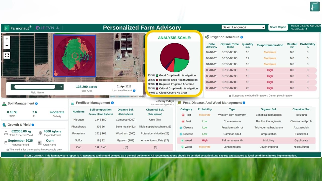
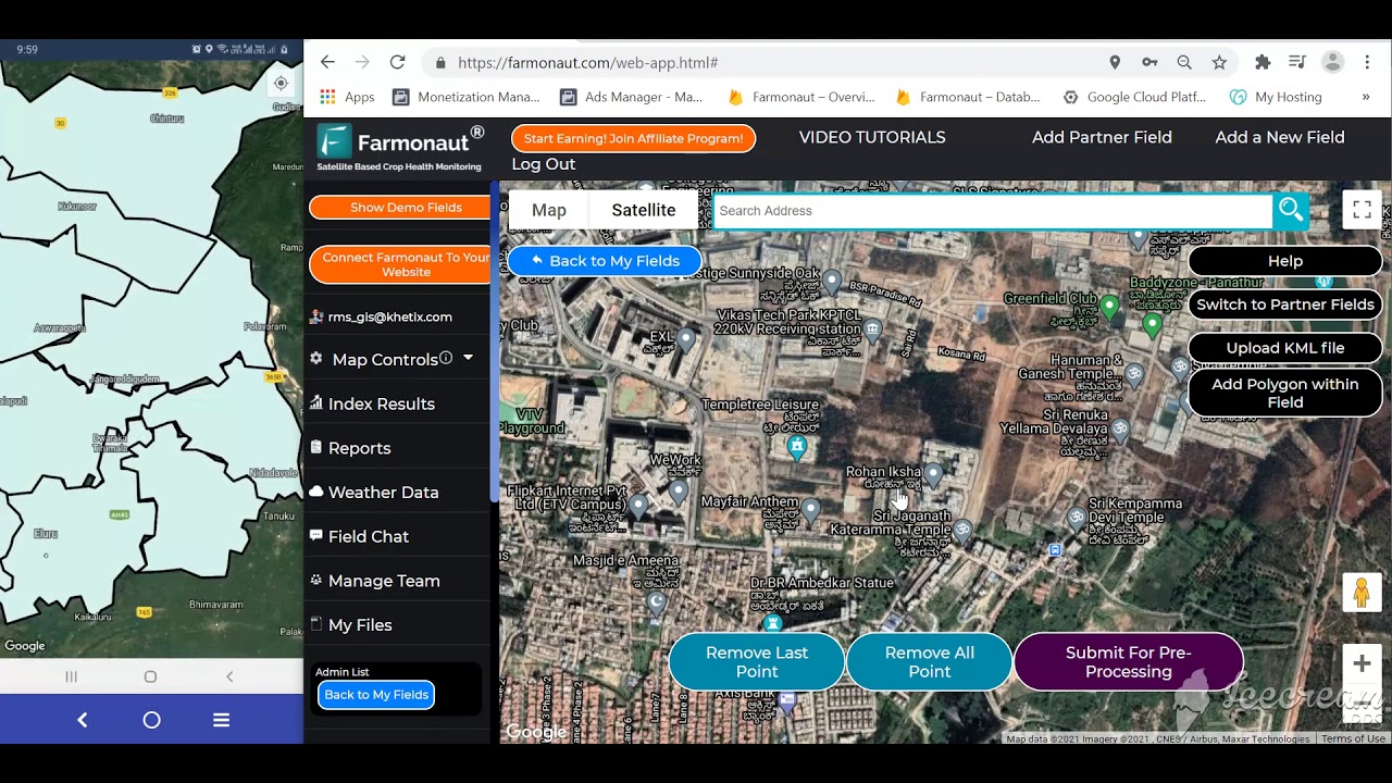
- Satellite-Based Crop Health Monitoring: We provide richly detailed NDVI, soil moisture, and vegetation health data accessible via web, iOS, and Android platforms. This empowers users to pinpoint and address crop issues long before harvest, increasing efficiency and yield.
- Jeevn AI Advisory System: Our AI-powered Jeepn system evaluates real-world satellite data to give actionable advisory insights—helping optimize every aspect of field management, reduce waste, and increase returns.
- Blockchain-Based Traceability: Through our digital traceability tools, users can track products from field to final customer, building transparency in global supply chains—see product traceability.
- Fleet & Resource Management: Our fleet management modules help agribusinesses organize vehicle routes, ensure safety, and minimize operational costs by leveraging field data and GPS tracking—learn more at Fleet Management.
- Carbon Footprinting: We support clients in tracking and lowering their agricultural CO₂ emissions for environmental compliance and better sustainability reporting. For more, visit carbon footprinting.
- Large-Scale & Government Solutions: Our platform is built to serve individual smallholder farmers up to the largest government monitoring programs for crop area, yield estimation, and resource allocation—see large scale farm management.
- API for Developers & Businesses: Developers and agrotechnology businesses can directly integrate our satellite weather API into their systems or tools—see API access and API developer documentation for technical details.
We make these insights accessible and actionable on mobile and web, eliminating the traditional high-cost barrier to entry for precision agriculture.


FAQ: GPS Farming Equipment & Precision Agriculture in 2025
1. How does GPS improve efficiency in corn farming?
GPS farming equipment improves efficiency by enabling auto-steering, optimized field routing, variable-rate planting and input application, and precise mapping. This reduces overlap, input waste, and operator fatigue, while increasing yield and lowering operational costs.
2. What environmental benefits are associated with GPS agriculture equipment?
Environmental benefits include reduced soil compaction, minimized chemical runoff, improved water management, and lower fuel usage—all aiding in sustainable corn and crop production.
3. Can small and medium farms benefit from GPS technologies?
Yes. While initial investment is higher, even small farms can recoup costs via input savings, higher yield, and improved sustainability—especially when using affordable satellite-based platforms like ours at Farmonaut.
4. Is GPS only useful for row crops like corn?
No. GPS is valuable in a spectrum of agriculture and forestry operations: from wheat, rice, and soybean fields to orchards, plantations, and large forest management.
5. What are the main challenges for GPS adoption in agriculture and forestry?
The key challenges include system cost, operator training, reliable signal coverage, and robust data management. Solutions are evolving to bring down barriers for diverse agricultural users.
6. What role will AI and satellites play in the future of GPS equipment?
Artificial intelligence, satellite imagery, and advanced sensors will further automate, optimize, and individualize equipment operations, offering farmers and producers global visibility, real-time analytics, and adaptive management solutions.
Choose the Best Plan for Your Precision Agriculture Needs
Farmonaut Apps, API, and Products for Precision Corn Farming
- Farmonaut App: Access our satellite-driven crop health and field monitoring for corn, wheat, rice, and orchards from anywhere. Get started with the Farmonaut App for GPS, mapping, and data-driven farm management.
- API and Documentation: Integrate real-time satellite data and weather insights directly into your own agricultural software or research tools. Check out Farmonaut’s API and API Developer Docs.
- Crop Plantation & Forest Advisory: Utilize satellite-driven advisory for forest, plantation, or crop management at crop plantation forest advisory.
- Fleet Management: Track, schedule, and optimize your agriculture equipment fleet with our robust tools for safety and resource efficiency: Farmonaut Fleet Management.
- Traceability: Secure your supply chain and add trust for buyers with blockchain-based traceability—connect GPS locations and digital harvest records for complete transparency.
- Carbon Footprinting: Evaluate and lower your field and logistic emissions for compliance and market demand. Learn more at carbon footprint tracking.
- Crop Loan & Insurance: Verify farm area, crop stage, and historic data to support credit and insurance applications with confidence.
Conclusion: A New Era for Agriculture and Forestry Equipment
GPS for farming equipment is no longer a futuristic luxury—it’s a necessity driving the next revolution in agriculture and forestry. From precision planting in corn fields to sustainable forest management, the
combination of satellite-enabled guidance, sensor-driven data, and digital platforms has set a new standard for productivity, profitability, and environmental stewardship in 2025 and beyond.
Ongoing innovation in autonomous machinery, advanced field mapping, cloud-based data analytics, and scalable digital platforms will ensure the entire agricultural sector—farmers, agribusinesses, and environmental professionals—can thrive in a world of resource constraints and climate challenges.
Embracing GPS farming equipment and next-gen agricultural technologies will remain the cornerstone of sustainable, efficient, and productive food systems worldwide.
With our mission at Farmonaut—to make precision agriculture accessible for all—we look forward to empowering producers, optimizing operations, and protecting the planet for generations to come.


