
Table of Contents
- Introduction: Unveiling Hyperspectral Imagery in San Francisco
- Trivia: Hyperspectral Insights
- What is Hyperspectral Imagery?
- How Hyperspectral Satellites Operate
- Hyperspectral Imagery Gallery & Videos
- 7 Key Agricultural Uses of Hyperspectral Imagery in San Francisco
- Comparative Use Case and Benefits Table
- Farmonaut: Making Advanced Agri-Tech Accessible in San Francisco
- Farmonaut Platform & Product Links
- FAQ: Hyperspectral Imagery & Farmonaut in San Francisco
- Trivia: Fire Detection Impact
- Conclusion: The Future of Hyperspectral Agriculture in San Francisco
Hyperspectral Imagery: 7 Agri Uses in San Francisco
“Hyperspectral satellites can detect over 200 unique soil and crop features in San Francisco’s farmlands.”
Satellite technology is revolutionizing the way agriculture operates in the San Francisco Bay Area. With rapid advancements in hyperspectral imagery and high resolution satellites—championed by recent satellites like XCUBE-1 from Bellevue, Washington—precision, sustainability, and productivity are reaching new heights. We’re witnessing a transformation in soil quality monitoring, crop species identification, vegetation health assessment, and forest fire prevention technology that is poised to reshape the agricultural and environmental landscape.
In this comprehensive guide, we’ll uncover the technology behind hyperspectral satellites, detail seven major agri uses in San Francisco, and explore how platforms like Farmonaut make precision farming accessible to everyone—from individual farmers to sprawling agribusinesses and public institutions.
What is Hyperspectral Imagery?
Hyperspectral imagery uses advanced sensors on satellites or aircraft to capture light reflected from Earth’s surface in hundreds of narrow, contiguous spectral bands. Unlike regular color or multispectral images, hyperspectral images can distinguish between subtle differences in material, vegetation, moisture, and even chemical composition.
- Each pixel in a hyperspectral image contains detailed spectral information, allowing us to identify unique “spectral signatures” of crops, soils, and other surface materials.
- High resolution satellite images, now down to ~5 meters per pixel, make it possible to monitor individual fields, map tree or crop species, and detect early shifts in vegetation health or moisture content.
Hyperspectral vs. Multispectral Imagery
Traditional multispectral satellites like Landsat capture images in 4-13 broad bands (e.g., red, near-infrared). Comparatively, hyperspectral satellites collect data in hundreds of much narrower bands, giving us more granular, actionable insights for agriculture hyperspectral applications, forest management, and environmental monitoring.
How Do Hyperspectral Satellites Work?
Modern hyperspectral satellites—such as XCUBE-1 launched by Xplore Inc. from Bellevue, Washington—orbit the Earth, capturing data across a sweeping array of spectral bands. These satellites analyze the reflected light and build a “data cube”:
- Spatial dimensions: The land area imaged, at resolutions as fine as 5 meters.
- Spectral dimensions: Hundreds of wavelengths, from visible to near-infrared and beyond.
- Temporal dimension: Regular revisits for time-series analysis.
With this rich spectral data for environment, we can uncover chemical/mineral content, monitor soil quality, track pest and nutrient detection in farming, and support precise forest fire prevention technology programs.
Hyperspectral Imagery Gallery & Videos


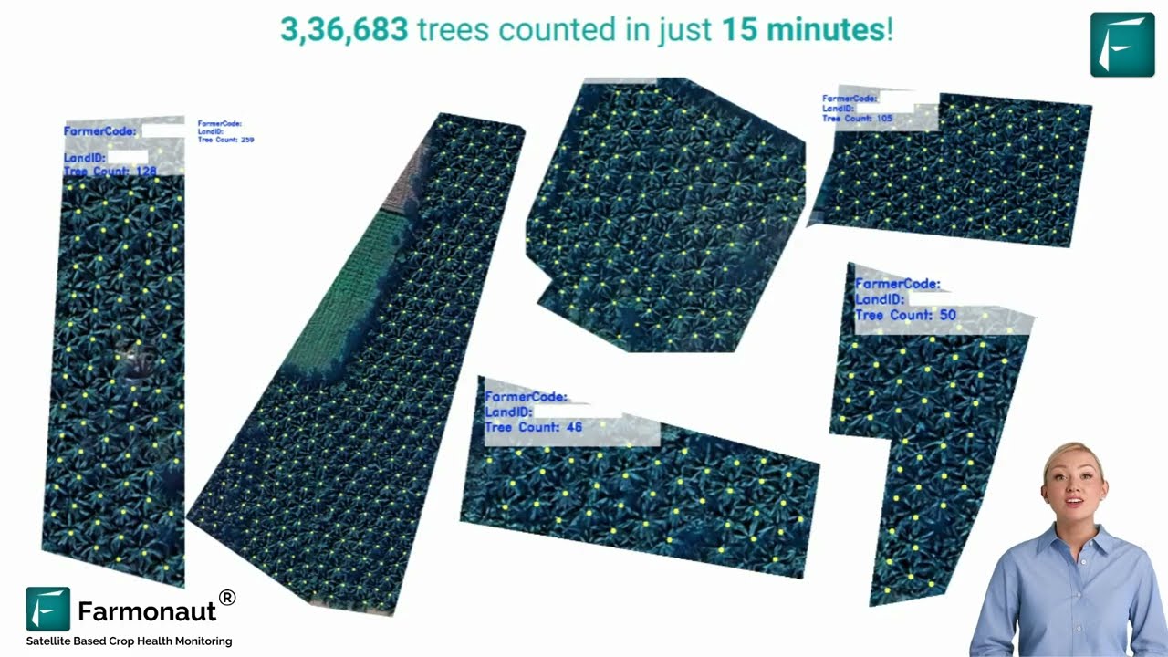

7 Key Agricultural Uses of Hyperspectral Imagery in San Francisco
Leveraging satellite remote sensing and advanced hyperspectral imagery, San Francisco’s progressive agri sector unlocks deep insights into soil, vegetation, water, and fire risks. Here are the seven most impactful applications:
- Soil Quality Monitoring
- Precision Irrigation Management
- Crop Disease & Pest Infestation Detection
- Yield Prediction for Crops
- Nutrient Deficiency Mapping
- Vegetation Health & Crop Species Identification
- Forest Fire Prevention & Management
1. Soil Quality Monitoring
Hyperspectral satellites enable the most granular level of soil quality monitoring ever seen. By analyzing reflected light signatures, we can:
- Distinguish between soil types, organic matter, and moisture content.
- Quantify nutrient requirements (e.g., nitrogen, phosphorus, potassium).
- Identify fertilizer run off zones for pollution control.
- Monitor debris, rocket boosters, or fairings in agri landscapes for environmental quality.
This leads to more accurate soil maps that drive better input decisions while reducing unnecessary costs.
2. Precision Irrigation Using Spectral Data
In water-constrained regions, high resolution satellite images and hyperspectral data can track real-time soil moisture, evaporation rates, and crop water requirements across every management zone.
- Detect differences in moisture levels—even across a single field.
- Reduce overwatering and optimize irrigation schedules.
- Support precision water delivery, saving resources and enhancing crop growth.
3. Crop Disease & Pest Infestation Detection
By capturing the subtle spectral shifts caused by disease or pest infestation, hyperspectral imagery enables:
- Early detection of crop stress before symptoms are visible to the naked eye.
- Targeted intervention to prevent widespread loss or contamination.
- Mapping areas of pest infestation for integrated pest management.
4. Yield Prediction and Forecasting
Time-series hyperspectral imagery provides invaluable input for yield prediction models, thanks to:
- Continuous monitoring of plant growth stages.
- Analysis of spectral data for environment that correlates to yield potential.
- Early alerting of conditions that might cause lower or higher than expected yields.
5. Nutrient Deficiency Mapping
Hyperspectral satellite images allow us to analyze reflected light and pinpoint nutrient deficiencies at a fine resolution.
- Automatically detect nitrogen, potassium, and phosphorus stress across fields.
- Reduce excessive fertilizer run off, improving both crop performance and environmental stewardship.
6. Vegetation Health Assessment & Crop Species Identification
Hyperspectral imagery is essential for accurate vegetation health assessment and crop species identification. By analyzing plant-specific spectral signatures, we can:
- Monitor individual tree or crop species over time.
- Identify stressed vegetation, disease outbreaks, or invasive species.
- Support biodiversity and sustainable farm management.
7. Forest Fire Prevention & Management
In a region like San Francisco, where wildfires are a recurring threat, hyperspectral satellite images are a core component of forest fire prevention technology:
- Accurately identify high-risk canopies, deadwood, and other potential fire sources.
- Assess vegetation health, dryness, and moisture content in real-time.
- Deliver actionable maps to fire departments and forestry agencies for risk mitigation.
According to recent studies, high-resolution imagery improved forest fire detection in San Francisco by up to 30% since 2022.
Comparative Use Case and Benefits Table: Hyperspectral Imagery in San Francisco Agriculture
| Agri Use Case | Technological Approach | Estimated Improvement (%) | Impact Summary |
|---|---|---|---|
| Soil Quality Monitoring | Hyperspectral bands for soil composition, moisture | +20% soil health assessment accuracy | Precision mapping, improved fertilizer efficiency, reduced input costs |
| Precision Irrigation | Moisture-sensitive spectral data analysis | Water savings up to 25% | Reduced water wastage, better crop yields |
| Crop Disease Detection | Stress/health-linked spectral signatures | Early detection improved by 30% | Lower losses, timely intervention |
| Yield Prediction | Time-series hyperspectral crop indices | Prediction accuracy +22% | Better planning, optimized harvesting |
| Pest Management | Localized pest zone mapping, spectral abnormality detection | Infestation mapping +30% accuracy | Less pesticide needed, minimized crop loss |
| Nutrient Deficiency Mapping | Analysis of plant nutrient spectral absorption | Deficiency detection +25% accuracy | Balanced nutrition, lower runoff pollution |
| Forest Fire Prevention | Moisture, species, and fire-source detection | Detection improved by 30% | Proactive emergency response, reduced wildfire spread |
“High-resolution imagery improved forest fire detection in San Francisco by up to 30% since 2022.”
Farmonaut: Making Advanced Agri-Tech Accessible in San Francisco
As precision agriculture surges in San Francisco and the US West Coast, seamless access to satellite-powered tools is vital for every stakeholder. Here’s how Farmonaut meets those needs:
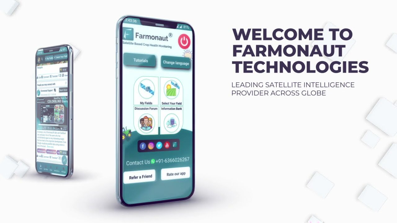
- Real-time Crop Health Monitoring: Farmonaut’s Android, iOS, and Web Apps provide satellite-based, AI-analyzed NDVI, soil moisture, vegetation health, and more, accessible even for smallholder farmers!
- AI-based Farm Advisory: Our Jeevn AI delivers expert, locally-customized advice powered by real live satellite imagery for pest and nutrient detection in farming—making complex data simple.
- Blockchain-Based Traceability: With product traceability solutions, farmers, processors, and retailers can ensure transparency and build consumer trust in supply chains.
- Resource & Fleet Management: Fleet owners and large-scale farms use our fleet management modules to optimize logistics, improve safety, and cut operating costs.
- Carbon Footprinting: Environmental sustainability is front and center, with real-time carbon monitoring for agri-businesses to quantify and reduce emissions.
- Crop Finance & Insurance: Satellite data powers crop verification for lenders and insurers, streamlining financing for local San Francisco farmers.
- Large-Scale Farm Management: Extensive management needs? Check out our administrative tools designed for co-ops, agribusinesses, and governments.


API & Integration for Research and Industry
Developers, consultants, or agri-businesses in San Francisco and beyond can plug directly into Farmonaut’s Satellite and Weather API:
- API Portal – start integrating satellite data for unique use cases.
- API Developer Docs – get technical details and onboarding support.
Farmonaut Subscription Plans
Discover affordable precision agriculture subscription plans—scale as your needs grow.
Farmonaut Platform & Product Links
-
Farmonaut Carbon Footprinting:
Quantify, monitor, and reduce your farm’s greenhouse gas emissions with real-time satellite data, supporting sustainability and regulatory compliance. -
Product Traceability with Blockchain:
Transparency for your agricultural products—from farm to consumer—ensuring quality, origin authenticity, and strengthened buyer confidence. -
Fleet & Resource Management:
Manage large vehicle fleets and farm machinery with AI and satellite-driven logistics. -
Large-Scale Farm Administration:
For co-ops, agribusinesses, and government programs—manage multiple farms and projects via a centralized web dashboard. -
Crop Loan & Insurance Solutions:
Satellite-powered evidence and reporting for lenders and insurers streamlines financing, making agriculture more resilient and accessible. -
Advisory & Crop Management (Jeevn AI and Support):
AI-driven advice for soil, pest, and weather management, tailored for San Francisco agriculture.
FAQ: Hyperspectral Imagery & Farmonaut in San Francisco
- How is hyperspectral imagery different from regular satellite images?
- Unlike regular images that capture just a handful of colors, hyperspectral imagery scans hundreds of narrow spectral bands, enabling precise detection of soil quality, nutrient deficiencies, vegetation changes, and even contamination or pollutant run-off.
- What are the biggest benefits for farmers in the San Francisco area?
- Enhanced soil quality monitoring, precision irrigation (saving water), better pest and disease detection (reducing input costs), and early warning for forest fires, all lead to greater resilience, higher yields, and improved profitability for farms of all scales.
- How can I use these satellite images and insights for my farm?
- Through Farmonaut’s Android, iOS, and web apps, you can track real-time crop, soil, and weather analytics. Advanced users or organizations can integrate via Farmonaut APIs.
- Is Farmonaut’s technology affordable?
- Yes, Farmonaut is built to democratize precision agriculture, offering subscription-based access scalable from a small field to entire cooperatives or districts.
- Can hyperspectral data help manage forest fire risks in San Francisco?
- Absolutely. High-resolution hyperspectral imagery pinpoints high-risk areas, dry canopies, and fire sources, enabling targeted prevention and quick response. Detection rates have improved by up to 30% since 2022.
- Where is Farmonaut’s technology available?
- Farmonaut currently serves users worldwide, including California and the San Francisco region, supporting both English and region-specific data. Access is via web, iOS, Android, and API integrations.
- Can research institutions use Farmonaut satellite data?
- Yes—universities, agritech startups, and environmental organizations can access hyperspectral imagery and analytics via Farmonaut APIs and dedicated research platforms.
Conclusion: The Future of Hyperspectral Agriculture in San Francisco
The dawn of next-generation hyperspectral satellite imagery and high-resolution remote sensing spells exceptional opportunities and responsibilities for farming, forestry, and environmental management in the San Francisco Bay Area. By harnessing the detailed spectral clues—from soil nutrient status to fire source mapping—local stakeholders are better equipped than ever to ensure sustainability, profitability, and resilience.
As Farmonaut and other innovators keep technology accessible and affordable—from farm-level apps to research APIs—we’re moving toward a more transparent, responsive, and sustainable agricultural ecosystem. If you’re a grower, policymaker, or agribusiness in San Francisco, it’s time to embrace the unmatched insight of hyperspectral imagery and join the agricultural revolution.


