Revolutionizing Farm Mapping: Farmonaut’s AI-Powered Boundary Detection System
In the ever-evolving world of agriculture, precision and efficiency are paramount. At Farmonaut®, we’re proud to introduce our latest innovation that’s set to transform the way farmers map and manage their land: the Automated AI-based Boundary Detection System. This cutting-edge technology is not just a step forward; it’s a giant leap in the realm of farm mapping and management.
The Challenge of Traditional Farm Mapping
For generations, farmers have grappled with the complexities of accurately mapping their land. The traditional methods were often:
- Time-consuming
- Labor-intensive
- Prone to human error
- Inefficient for large-scale operations
These challenges have long been a thorn in the side of agricultural efficiency, hindering productivity and resource management. But today, we’re excited to announce that these struggles are becoming a thing of the past.
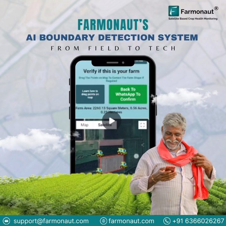
Introducing Farmonaut’s Automated AI-based Boundary Detection System
Our revolutionary system is designed to address the pain points of traditional farm mapping methods. With just a single coordinate input, farmers can now map their entire farm with unprecedented accuracy and speed. This isn’t just an incremental improvement; it’s a complete overhaul of the farm mapping process.
Key Features of Our Boundary Detection System:
- Single Coordinate Input: Gone are the days of walking your entire property line. One coordinate is all you need to get started.
- AI-Powered Accuracy: Our advanced algorithms ensure precise boundary detection, minimizing errors.
- Time-Efficient: What used to take days or weeks can now be accomplished in a matter of minutes.
- Scalability: Whether you’re managing a small plot or vast acres, our system adapts to your needs.
- Integration with Satellite Data: Leverage the power of satellite imagery for comprehensive farm insights.
The Impact on Modern Farming
The introduction of our automated farm boundary detection system is set to have far-reaching implications for the agricultural sector. Let’s delve into how this technology addresses key challenges and transforms farming practices:
1. Eliminating Uncertainty in Land Boundaries
One of the most significant advantages of our system is its ability to provide clear, precise farm boundary delineation. This addresses a long-standing issue in agriculture:
- Dispute Resolution: Clear boundaries reduce conflicts with neighboring farms.
- Legal Clarity: Accurate maps provide solid documentation for legal and administrative purposes.
- Planning Precision: Farmers can plan their crops and resources with exact knowledge of their land area.
2. Streamlining Large-Scale Operations
For farmers managing extensive lands or multiple plots, our field boundary detection system is a game-changer:
- Efficient Resource Allocation: Accurately map and plan for each section of your farm.
- Simplified Management: Oversee multiple farms or plots from a centralized platform.
- Data-Driven Decisions: Use precise boundary data to inform crop rotation, irrigation, and fertilization strategies.
3. Time and Cost Savings
The efficiency of our AI-based system translates directly into tangible benefits:
- Reduced Labor Costs: Eliminate the need for manual surveying teams.
- Quick Turnaround: Get your farm mapped in minutes, not days or weeks.
- Reallocation of Resources: Invest the time and money saved into other crucial farming activities.
The Technology Behind the Magic
At the heart of our farm mapping revolution is a sophisticated blend of technologies:
1. Artificial Intelligence and Machine Learning
Our AI algorithms are trained on vast datasets of agricultural lands, allowing them to recognize and delineate farm boundaries with exceptional accuracy. The system continually learns and improves, adapting to various landscapes and farm types.
2. Satellite Imagery Integration
We leverage high-resolution satellite imagery to provide a bird’s-eye view of your farm. This integration allows for:
- Real-time updates on land changes
- Seasonal monitoring of crop growth
- Detection of anomalies or issues within your farm boundaries
3. Geospatial Analysis
Advanced geospatial tools process and analyze the data, ensuring that every acre of your farm is accurately represented. This technology allows for precise area calculations, crucial for resource planning and yield estimations.
Practical Applications Across Farming Sectors
Our AI-based boundary detection system isn’t just a one-size-fits-all solution. It’s versatile enough to cater to various agricultural needs:
1. Crop Farming
For crop farmers, accurate boundary detection is crucial for:
- Precise crop planning and rotation
- Efficient irrigation system design
- Accurate yield predictions
2. Livestock Farming
Livestock farmers benefit from:
- Pasture management and rotation planning
- Fencing strategy optimization
- Grazing area calculations
3. Orchard and Vineyard Management
For specialized crops like fruits and vines:
- Precise row planning and spacing
- Optimized harvesting routes
- Targeted pest and disease management
4. Cotton Farming
Cotton farming, a sector that often deals with large, complex field structures, particularly benefits from our system:
- Accurate delineation of cotton fields for precision agriculture
- Optimized irrigation planning for water-intensive cotton crops
- Enhanced pest management strategies across large cotton plantations
Integrating with Farmonaut’s Ecosystem
While our AI-based boundary detection system is powerful on its own, its true potential is realized when integrated with Farmonaut’s broader suite of agricultural technologies:
1. Jeevn AI Advisory System
Our AI-driven farm advisory tool works in tandem with the boundary detection system to provide:
- Customized crop recommendations based on your specific field boundaries
- Tailored weather forecasts for your exact farm location
- Pest and disease alerts specific to your farm’s geographical area
2. Satellite-Based Crop Health Monitoring
With precise farm boundaries, our satellite monitoring becomes even more powerful:
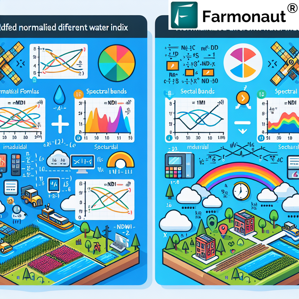
- Accurate NDVI (Normalized Difference Vegetation Index) calculations for your exact field area
- Precise soil moisture analysis within your farm boundaries
- Early detection of crop stress or health issues in specific sections of your farm
3. Blockchain-Based Traceability
For farmers looking to leverage blockchain for supply chain transparency:
- Exact geolocation tagging of crops within your farm boundaries
- Enhanced product traceability from specific field sections to consumers
- Improved credibility for organic and sustainable farming practices
Comparison: Farmonaut Satellite System vs. Drone and IoT-Based Monitoring
| Feature | Farmonaut Satellite System | Drone-Based Monitoring | IoT-Based Monitoring |
|---|---|---|---|
| Coverage Area | Unlimited (Global) | Limited by flight range | Limited by sensor placement |
| Frequency of Data Collection | Daily to weekly | As per flight schedule | Continuous |
| Initial Setup Cost | Low | High (Drone purchase) | Medium to High (Sensors) |
| Operational Complexity | Low (Cloud-based) | High (Requires skilled operator) | Medium (Maintenance required) |
| Weather Dependency | Low | High | Low |
| Data Processing | Automated (AI-driven) | Manual or semi-automated | Automated |
| Scalability | Highly scalable | Limited by equipment | Scalable but costly |
The Future of Farm Mapping and Management
As we look to the future, the potential applications and advancements in AI-based farm mapping are truly exciting:
1. Integration with Autonomous Farming Equipment
Imagine self-driving tractors and harvesters that know exactly where your farm boundaries are, operating with pinpoint accuracy without any human intervention.
2. Enhanced Predictive Analytics
By combining precise boundary data with historical yield information and real-time satellite imagery, we’re working towards even more accurate yield predictions and crop management recommendations.
3. Climate Change Adaptation
As climate patterns shift, having accurate farm boundary data will be crucial for adapting farming practices. Our system will help farmers make informed decisions about crop choices and land use based on changing environmental conditions.
4. Improved Sustainability Tracking
With exact boundary information, farmers will be able to more accurately track and report on their sustainability efforts, from carbon sequestration to biodiversity conservation.
Getting Started with Farmonaut’s AI Boundary Detection System
Ready to revolutionize your farm mapping and management? Here’s how you can get started:
- Sign Up: Visit our website or download our app to create your Farmonaut account.
- Input Your Location: Simply provide a single coordinate within your farm.
- AI Magic: Watch as our system automatically detects and maps your farm boundaries.
- Verify and Adjust: Review the generated map and make any necessary adjustments.
- Integrate and Optimize: Start using your accurate farm map with our other tools for comprehensive farm management.
Download our app now:
API Access for Developers
For developers and agtech companies looking to integrate our powerful mapping and satellite data into their own solutions, we offer comprehensive API access. Learn more about our API capabilities and documentation here.
Pricing and Subscriptions
We believe in making advanced agricultural technology accessible to farms of all sizes. Our flexible pricing model ensures that whether you’re managing a small family farm or a large agricultural operation, you can benefit from our AI-powered boundary detection system.
Frequently Asked Questions (FAQ)
Q: How accurate is the AI-based boundary detection system?
A: Our system boasts an accuracy rate of over 95% in most cases. Factors like field complexity and satellite image quality can affect accuracy, but our AI continuously improves its performance.
Q: Can the system detect boundaries for irregularly shaped fields?
A: Yes, our AI is trained to recognize and map fields of all shapes and sizes, including irregular and complex boundaries.
Q: How often is the boundary data updated?
A: While the initial boundary detection is based on the latest available satellite imagery, you can manually update or refine the boundaries at any time. We also periodically check for significant changes and alert you if updates are needed.
Q: Is this system suitable for small farms?
A: Absolutely! Our system is designed to work for farms of all sizes, from small family plots to large commercial operations.
Q: Can I integrate this boundary data with other farm management software?
A: Yes, we offer API access that allows for seamless integration with various farm management systems. Check our developer documentation for more details.
Q: How does this system help with compliance and reporting?
A: Accurate boundary data is crucial for regulatory compliance, subsidy applications, and environmental reporting. Our system provides verifiable, precise data that can be used for these purposes.
Q: Is training required to use this system?
A: The system is designed to be user-friendly and intuitive. However, we provide comprehensive guides and customer support to ensure you can make the most of all features.
Conclusion: Embracing the Future of Farming
At Farmonaut, we’re not just providing a tool; we’re offering a gateway to the future of agriculture. Our AI-based boundary detection system is more than a mapping solution – it’s a comprehensive farm management revolution. By combining cutting-edge technology with user-friendly interfaces, we’re empowering farmers of all scales to optimize their operations, increase productivity, and contribute to sustainable agricultural practices.
The challenges of traditional farm mapping – uncertainty, inefficiency, and inaccuracy – are now relics of the past. With Farmonaut’s innovative solution, you’re equipped to face the agricultural challenges of tomorrow. Whether you’re managing vast cotton fields in Texas, diversified crops in California, or a small family farm anywhere in the world, our system adapts to your needs, providing precision, efficiency, and insight.
We invite you to join us in this agricultural revolution. Experience the power of AI-driven farm mapping and unlock the full potential of your land. With Farmonaut, the future of farming is not just a distant dream – it’s here, it’s accessible, and it’s ready to transform your agricultural journey.
Ready to map your way to success? Get started with Farmonaut today and take the first step towards smarter, more efficient farming. Together, let’s cultivate a future where precision, sustainability, and prosperity go hand in hand.