Revolutionizing Agriculture: How AI-Powered Satellite Imagery Drives Precision Farming Decisions
“AI-powered satellite imagery can analyze up to 5 crucial vegetation indexes, including NDVI, GCI, and NDWI, for precision farming.”
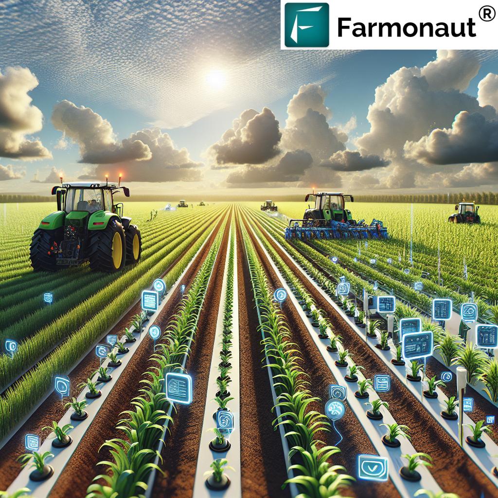
In the ever-evolving landscape of modern agriculture, we are witnessing a remarkable transformation driven by the convergence of artificial intelligence (AI) and satellite technology. This revolutionary approach is reshaping the way we understand and manage our farms, ushering in an era of precision agriculture that promises to enhance productivity, sustainability, and resource efficiency. At the forefront of this agricultural revolution is Farmonaut, a pioneering company that harnesses the power of AI-powered satellite imagery to empower farmers with data-driven insights and decision-making tools.
In this comprehensive blog post, we’ll explore how satellite imagery and AI are revolutionizing precision farming and crop management. We’ll delve into the fascinating world of remote sensing in agriculture, showcasing how advanced satellite data analysis enables farmers to make informed decisions for sustainable agriculture practices. Join us as we uncover the potential of satellite-based crop monitoring in transforming modern farming techniques and driving efficiency in global agriculture.
The Power of Satellite Imagery in Agriculture
Satellite imagery has emerged as a game-changing tool in the agricultural sector, offering farmers unprecedented access to valuable information about their crops and land. By leveraging high-resolution images captured by satellites orbiting the Earth, we can now gain a bird’s-eye view of vast agricultural areas, providing insights that were previously impossible to obtain.
The application of satellite imagery in agriculture offers numerous benefits:
- Large-scale monitoring: Satellites can cover vast areas of farmland, allowing for comprehensive monitoring of entire regions.
- Frequent updates: Regular satellite passes provide up-to-date information on crop health and field conditions.
- Non-invasive: Satellite monitoring doesn’t require physical presence in the fields, reducing disturbance to crops and soil.
- Cost-effective: Compared to traditional surveying methods, satellite imagery offers a more affordable solution for large-scale farm management.
- Historical data: Archived satellite images allow for analysis of long-term trends and patterns in crop performance.
At Farmonaut, we harness the power of satellite imagery to provide farmers with actionable insights that drive precision farming decisions. Our platform integrates advanced satellite data analysis with AI algorithms to deliver real-time information on crop health, soil moisture, and other critical metrics.
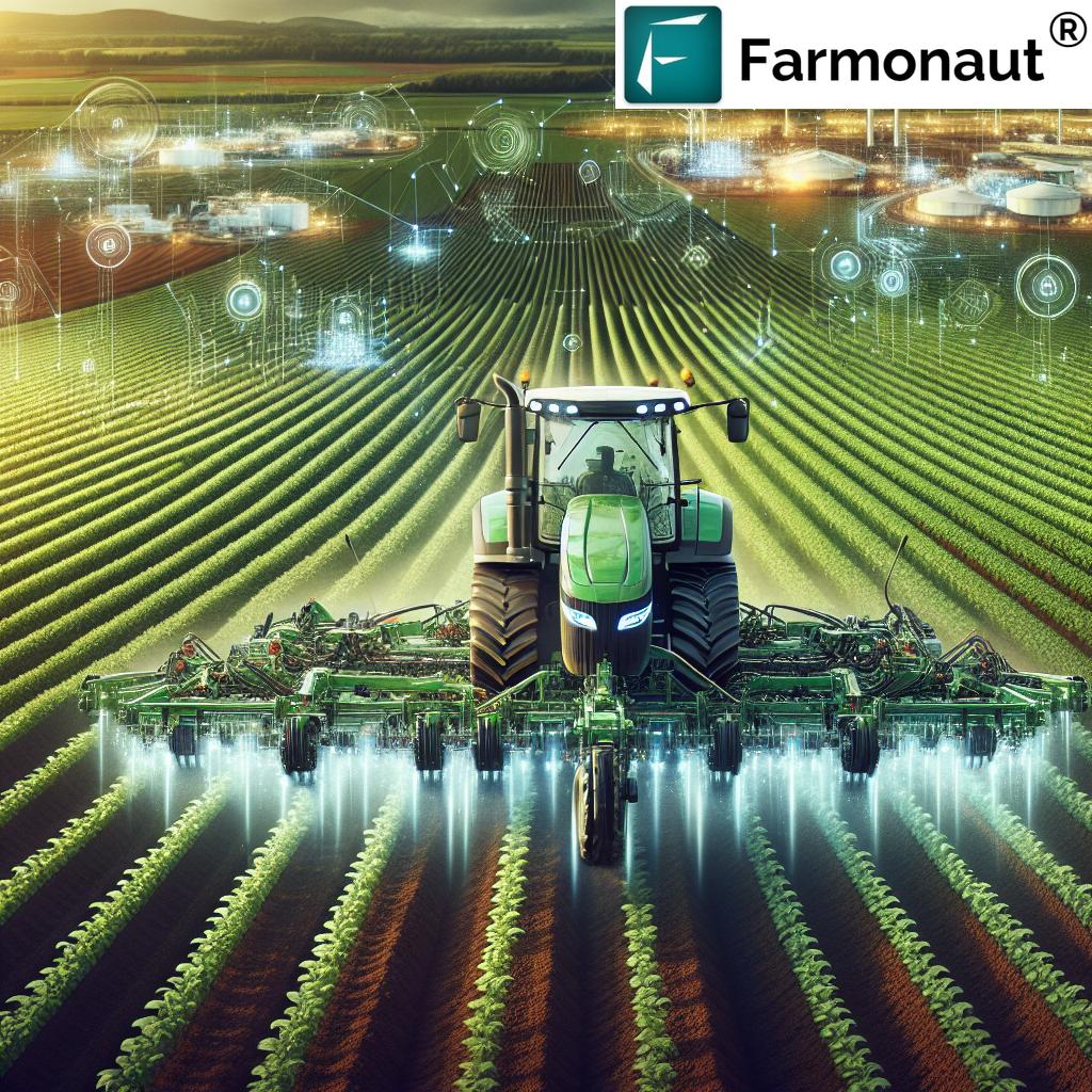
Precision Farming Technology: The Role of AI
Artificial Intelligence plays a pivotal role in transforming raw satellite data into meaningful insights for farmers. By leveraging machine learning algorithms and advanced data analytics, AI can process vast amounts of satellite imagery and extract valuable information about crop health, soil conditions, and potential issues.
Here’s how AI enhances precision farming technology:
- Pattern recognition: AI algorithms can identify patterns in satellite images that may be imperceptible to the human eye, such as early signs of pest infestations or nutrient deficiencies.
- Predictive analytics: By analyzing historical data and current conditions, AI can predict future crop performance and potential risks.
- Automated alerts: AI-powered systems can generate automated alerts for farmers when specific conditions are detected, enabling timely interventions.
- Resource optimization: AI can help optimize resource allocation by recommending precise amounts of water, fertilizer, and other inputs based on real-time crop needs.
Farmonaut’s AI-powered farm analytics platform leverages these capabilities to provide farmers with comprehensive insights and recommendations. Our Jeevn AI Advisory System analyzes satellite data and other inputs to generate customized advice, improving farm productivity and efficiency.
Remote Sensing for Crop Management: A Game-Changer
Remote sensing technology has revolutionized crop management by providing farmers with a wealth of information about their fields without the need for extensive on-ground surveys. This non-invasive approach allows for continuous monitoring of crop health, growth patterns, and environmental conditions.
Key applications of remote sensing in crop management include:
- Crop health assessment: Remote sensing can detect variations in plant vigor and identify areas of stress or disease.
- Yield estimation: By analyzing vegetation indices and historical data, remote sensing can help predict crop yields with increasing accuracy.
- Irrigation management: Satellite-based soil moisture monitoring can inform irrigation decisions, optimizing water usage.
- Pest and disease detection: Early identification of pest infestations or disease outbreaks allows for timely interventions.
- Nutrient management: Remote sensing can help identify areas of nutrient deficiency, enabling targeted fertilizer application.
At Farmonaut, we leverage advanced remote sensing techniques to provide farmers with comprehensive crop management solutions. Our satellite-based crop monitoring system offers real-time insights into vegetation health, soil moisture levels, and other critical metrics, empowering farmers to make data-driven decisions.
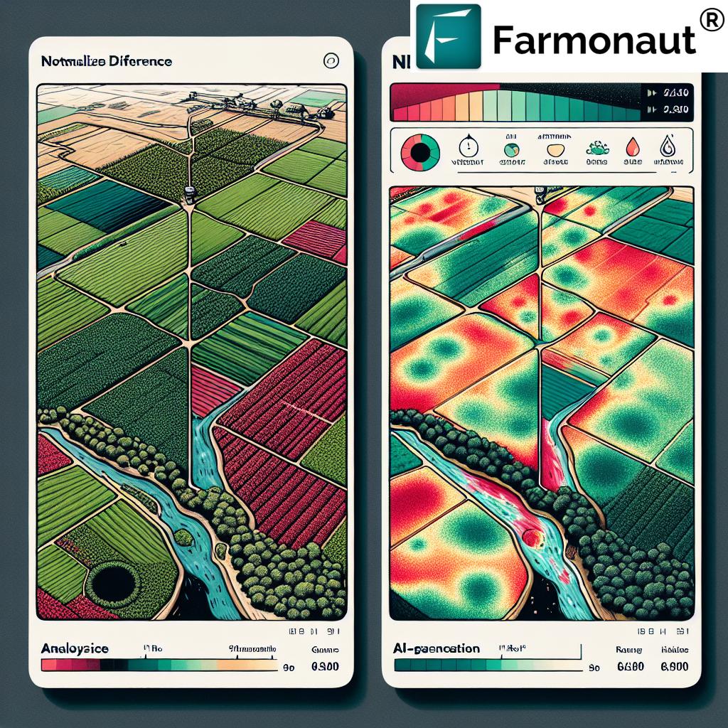
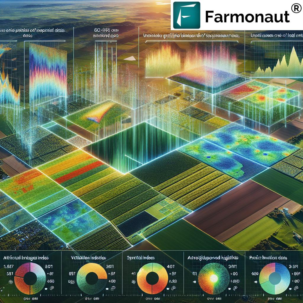
Understanding Vegetation Indexes in Agriculture
Vegetation indexes are crucial tools in precision agriculture, providing valuable insights into crop health and performance. These indexes are derived from satellite imagery and help farmers assess various aspects of their crops, from overall vigor to specific stress factors.
“Farmonaut’s technology leverages 3 key resolutions – spatial, temporal, and spectral – to enhance crop monitoring and increase ROI.”
Let’s explore some of the most important vegetation indexes used in precision farming:
| Index Name | Description | Applications | Benefits |
|---|---|---|---|
| NDVI (Normalized Difference Vegetation Index) | Measures the difference between near-infrared (NIR) and red light reflected by vegetation | Overall crop health assessment, biomass estimation, yield prediction | Provides a quick overview of plant vigor and density |
| GCI (Green Chlorophyll Index) | Estimates the amount of chlorophyll in leaves using green and NIR bands | Nitrogen status assessment, early stress detection | Helps optimize fertilizer application and identify nutrient deficiencies |
| NDWI (Normalized Difference Water Index) | Measures vegetation water content using NIR and short-wave infrared (SWIR) bands | Water stress detection, irrigation management | Enables efficient water use and early detection of drought stress |
These vegetation indexes form the backbone of satellite-based crop monitoring systems, providing farmers with valuable insights into their crops’ health and performance. By analyzing these indexes, we can identify areas of stress, optimize resource allocation, and make data-driven decisions to improve overall farm productivity.
Farmonaut’s platform utilizes these crucial vegetation indexes, along with other advanced metrics, to provide farmers with a comprehensive view of their crops’ health and performance. Our AI-powered analytics system interprets these indexes to generate actionable insights and recommendations for optimal farm management.
The Power of NDVI in Agriculture
The Normalized Difference Vegetation Index (NDVI) is one of the most widely used vegetation indexes in precision agriculture. NDVI provides valuable information about plant health and density by measuring the difference between near-infrared (NIR) and red light reflected by vegetation.
Here’s why NDVI is so important in agriculture:
- Crop health assessment: NDVI values correlate strongly with overall plant health and vigor.
- Biomass estimation: Higher NDVI values generally indicate greater biomass and leaf area.
- Yield prediction: NDVI data can be used to estimate potential crop yields.
- Stress detection: Changes in NDVI over time can reveal areas of crop stress or disease.
- Zonal management: NDVI maps enable farmers to identify and manage different zones within their fields.
At Farmonaut, we utilize NDVI along with other advanced vegetation indexes to provide farmers with comprehensive insights into their crops’ health and performance. Our AI-powered analytics system interprets NDVI data to generate actionable recommendations for optimal farm management.
Leveraging AI-Powered Farm Analytics
Artificial Intelligence is transforming the way we analyze and interpret agricultural data. AI-powered farm analytics platforms, like the one offered by Farmonaut, can process vast amounts of satellite imagery and other data sources to provide farmers with actionable insights and recommendations.
Key advantages of AI-powered farm analytics include:
- Real-time monitoring: AI systems can continuously analyze incoming satellite data, providing up-to-date information on crop conditions.
- Predictive capabilities: By analyzing historical data and current trends, AI can predict future crop performance and potential issues.
- Automated alerts: AI-powered systems can generate alerts when specific conditions are detected, enabling timely interventions.
- Customized recommendations: AI can provide tailored advice based on specific farm conditions and crop types.
- Resource optimization: AI analytics can help optimize the use of water, fertilizers, and other inputs, improving efficiency and reducing costs.
Farmonaut’s AI-powered farm analytics platform leverages advanced algorithms to transform satellite data into actionable insights. Our Jeevn AI Advisory System provides personalized recommendations and alerts, helping farmers make informed decisions and optimize their operations.
Vegetation Health Monitoring: A Key to Sustainable Farming
Effective vegetation health monitoring is essential for sustainable agriculture practices. By closely tracking the health and vigor of crops throughout the growing season, farmers can identify and address issues early, optimize resource use, and improve overall yields.
Satellite-based vegetation health monitoring offers several advantages:
- Wide-area coverage: Satellites can monitor vast agricultural areas efficiently.
- Frequent updates: Regular satellite passes provide timely information on crop conditions.
- Non-invasive: Satellite monitoring doesn’t disturb crops or soil.
- Historical comparisons: Archived satellite data allows for analysis of long-term trends.
- Cost-effective: Satellite monitoring is more affordable than traditional surveying methods for large areas.
Farmonaut’s vegetation health monitoring system utilizes advanced satellite imagery and AI analytics to provide farmers with comprehensive insights into their crops’ health. Our platform enables early detection of stress factors, disease outbreaks, and nutrient deficiencies, allowing for timely interventions and improved crop management.
Satellite-Based Crop Monitoring: The Future of Farming
Satellite-based crop monitoring represents the cutting edge of precision agriculture, offering farmers unprecedented insights into their fields and crops. This technology enables farmers to make data-driven decisions, optimize resource use, and improve overall farm productivity.
Key benefits of satellite-based crop monitoring include:
- Large-scale monitoring: Satellites can cover vast agricultural areas efficiently.
- Frequent updates: Regular satellite passes provide timely information on crop conditions.
- Multi-spectral analysis: Satellites capture data across various spectral bands, revealing information invisible to the naked eye.
- Historical data analysis: Archived satellite imagery allows for long-term trend analysis and comparison.
- Cost-effective solution: Satellite monitoring is more affordable than traditional surveying methods for large areas.
Farmonaut’s satellite-based crop monitoring system leverages cutting-edge technology to provide farmers with comprehensive insights into their crops’ health and performance. Our platform integrates multi-spectral satellite imagery, AI-powered analytics, and expert agronomic knowledge to deliver actionable recommendations for optimal farm management.
Data-Driven Farming Decisions: The Key to Success
In today’s competitive agricultural landscape, making informed, data-driven decisions is crucial for success. By leveraging the power of satellite imagery, AI analytics, and advanced vegetation indexes, farmers can gain a comprehensive understanding of their fields and crops, enabling them to make more accurate and timely decisions.
Benefits of data-driven farming decisions include:
- Improved resource allocation: Data-driven insights help optimize the use of water, fertilizers, and other inputs.
- Early problem detection: Timely identification of issues allows for proactive management and reduced crop losses.
- Yield optimization: Data-driven decisions can lead to improved crop yields and quality.
- Risk mitigation: Better information helps farmers prepare for and manage potential risks.
- Sustainability: Data-driven farming practices often lead to more sustainable and environmentally friendly operations.
Farmonaut’s platform is designed to empower farmers with the data and insights they need to make informed decisions. Our AI-powered analytics system processes satellite imagery and other data sources to provide actionable recommendations, helping farmers optimize their operations and improve their bottom line.
Sustainable Agriculture Practices Through Technology
As the global population continues to grow and climate change poses new challenges, sustainable agriculture practices have become more important than ever. Advanced technologies like satellite imagery and AI-powered analytics play a crucial role in promoting and enabling sustainable farming methods.
Here’s how technology contributes to sustainable agriculture:
- Precision resource management: Satellite-based monitoring helps optimize the use of water, fertilizers, and pesticides, reducing waste and environmental impact.
- Soil health preservation: Data-driven insights enable farmers to implement practices that preserve and improve soil health.
- Biodiversity conservation: Advanced monitoring can help identify and protect areas of high biodiversity within agricultural landscapes.
- Carbon footprint reduction: Efficient resource use and improved farming practices can help reduce the overall carbon footprint of agricultural operations.
- Climate resilience: Data-driven decision-making helps farmers adapt to changing climate conditions and extreme weather events.
At Farmonaut, we are committed to promoting sustainable agriculture practices through our advanced technology solutions. Our platform provides farmers with the tools and insights they need to implement more sustainable farming methods, helping to ensure the long-term viability of their operations and the health of our planet.
Precision Agriculture Satellite Data: Unlocking Farm Potential
Precision agriculture satellite data has become an invaluable tool for modern farmers, providing a wealth of information that can help unlock the full potential of their farms. By harnessing the power of satellite imagery and advanced analytics, farmers can gain unprecedented insights into their fields and crops.
Key advantages of precision agriculture satellite data include:
- High-resolution imagery: Modern satellites provide detailed images that can reveal subtle variations in crop health and field conditions.
- Multi-spectral analysis: Satellites capture data across various spectral bands, revealing information invisible to the naked eye.
- Frequent updates: Regular satellite passes provide timely information on crop conditions throughout the growing season.
- Large-scale coverage: Satellites can efficiently monitor vast agricultural areas, making them ideal for large farms and regional analysis.
- Historical data: Archived satellite imagery allows for long-term trend analysis and comparison.
Farmonaut’s platform leverages cutting-edge precision agriculture satellite data to provide farmers with comprehensive insights into their crops’ health and performance. Our advanced analytics system processes this data to generate actionable recommendations, helping farmers optimize their operations and improve yields.
The Future of Smart Farming
As we look to the future, it’s clear that smart farming technologies will play an increasingly important role in global agriculture. The integration of AI, satellite imagery, and advanced analytics is set to revolutionize the way we grow food, making farming more efficient, sustainable, and productive.
Key trends shaping the future of smart farming include:
- AI-driven decision support: Advanced AI systems will provide increasingly sophisticated recommendations for farm management.
- Internet of Things (IoT) integration: Connected sensors and devices will provide real-time data to complement satellite imagery.
- Automated farming systems: AI-powered robots and drones will assist with various farming tasks, from planting to harvesting.
- Predictive analytics: Advanced algorithms will forecast crop performance, weather impacts, and market trends with greater accuracy.
- Blockchain integration: Blockchain technology will enhance traceability and transparency in the agricultural supply chain.
At Farmonaut, we are at the forefront of these technological advancements, continuously innovating to provide farmers with the most advanced and effective smart farming solutions. Our commitment to research and development ensures that we remain at the cutting edge of agricultural technology, helping farmers thrive in an ever-changing world.
Conclusion: Embracing the Agricultural Revolution
The convergence of AI-powered satellite imagery and precision farming technologies is ushering in a new era of agriculture. This revolution promises to enhance productivity, sustainability, and resource efficiency, helping farmers meet the growing global demand for food while minimizing environmental impact.
As we’ve explored in this blog post, technologies like satellite-based crop monitoring, advanced vegetation indexes, and AI-powered analytics are transforming the way we approach farming. These tools provide farmers with unprecedented insights into their crops and fields, enabling data-driven decision-making and optimized farm management.
At Farmonaut, we are proud to be at the forefront of this agricultural revolution. Our innovative platform combines cutting-edge satellite technology with advanced AI analytics to provide farmers with the tools and insights they need to succeed in today’s competitive agricultural landscape.
We invite you to join us in embracing this exciting future of smart farming. Whether you’re a small-scale farmer or managing large agricultural operations, Farmonaut’s solutions can help you unlock the full potential of your farm and contribute to a more sustainable and productive agricultural sector.
To learn more about how Farmonaut can revolutionize your farming practices, visit our website or download our mobile app today. Together, let’s cultivate a smarter, more sustainable future for agriculture.
Explore Farmonaut’s Solutions:


For developers interested in integrating Farmonaut’s powerful satellite and weather data into their own applications, check out our API and API Developer Docs.
Farmonaut Subscriptions
Frequently Asked Questions (FAQ)
Q: What is precision farming, and how does it benefit farmers?
A: Precision farming is an approach that uses technology to optimize crop management and resource allocation. It benefits farmers by improving yields, reducing costs, and promoting sustainability through data-driven decision-making.
Q: How does satellite imagery contribute to precision agriculture?
A: Satellite imagery provides farmers with a comprehensive view of their fields, allowing them to monitor crop health, detect issues early, and make informed decisions about resource allocation and management practices.
Q: What are vegetation indexes, and why are they important in agriculture?
A: Vegetation indexes are mathematical calculations derived from satellite imagery that provide information about plant health and characteristics. They are important because they help farmers assess crop conditions, predict yields, and identify areas of stress or disease.
Q: How does AI enhance satellite-based crop monitoring?
A: AI processes vast amounts of satellite data quickly and accurately, identifying patterns and trends that might be missed by human analysis. It can generate automated alerts, predict future crop performance, and provide customized recommendations for farm management.
Q: What is NDVI, and how is it used in agriculture?
A: NDVI (Normalized Difference Vegetation Index) is a measure of plant health and density. It’s used in agriculture to assess overall crop health, estimate biomass, predict yields, and identify areas of stress or disease within fields.
Q: How does Farmonaut’s technology help farmers make data-driven decisions?
A: Farmonaut’s platform combines satellite imagery, AI analytics, and agronomic expertise to provide farmers with actionable insights and recommendations. This enables farmers to make informed decisions about crop management, resource allocation, and farm operations.
Q: Can satellite-based crop monitoring work for small farms?
A: Yes, satellite-based crop monitoring can be beneficial for farms of all sizes. Farmonaut’s solutions are designed to be scalable and accessible, providing valuable insights for both small-scale farmers and large agricultural operations.
Q: How does precision agriculture contribute to sustainable farming practices?
A: Precision agriculture promotes sustainability by optimizing resource use, reducing waste, and minimizing environmental impact. It helps farmers implement targeted management practices that improve soil health, conserve water, and reduce the use of chemicals.
Q: What is the future of smart farming technologies?
A: The future of smart farming involves increased integration of AI, IoT devices, automation, and advanced analytics. These technologies will continue to evolve, providing farmers with even more sophisticated tools for optimizing their operations and improving productivity.
Q: How can I get started with Farmonaut’s satellite-based crop monitoring solution?
A: To get started with Farmonaut, you can visit our website, download our mobile app, or contact our team for a consultation. We offer various subscription options to suit different farm sizes and needs, allowing you to leverage our advanced technology for your specific agricultural operations.