Agriculture UAV: Transforming Precision Farming in 2026
“By 2026, over 60% of large farms worldwide are projected to deploy UAVs for precision data collection.”
“In 2025, the agriculture UAV market is expected to surpass $3.5 billion in global value.”
Introduction
As agriculture faces the twin pressures of surging global food demand and intensifying environmental challenges, innovation is not just welcomed—it’s required. In 2026, agriculture UAV technology has rapidly assumed a central role in revolutionizing precision farming, enabling smarter, more efficient, and sustainable practices for farmers worldwide. Unlike traditional methods, today’s aerial drones furnish us with detailed data, advanced sensors, and AI-driven analytics—all designed to enhance productivity, minimize resource waste, and address environmental concerns.
This comprehensive guide delves deep into how UAV use in agriculture is empowering modern farmers, explains the workings of UAV drones for agriculture, highlights the latest precision agriculture UAV technologies in 2026 and beyond, and illustrates how they integrate into a holistic, data-powered agricultural ecosystem. Whether you’re a farmer, agribusiness leader, policymaker, or an enthusiast, this post provides you with a full-spectrum view of the future of farming.


The UAV Revolution in Modern Precision Agriculture
The rise of unmanned aerial vehicles (UAVs), more commonly known as drones, has been a game-changer for agriculture. Serving as aerial platforms equipped with advanced multispectral, hyperspectral, thermal, and RGB cameras, these UAVs now provide farmers and agricultural managers with real-time insights on crop health, soil conditions, irrigation status, and pest outbreaks.
Agriculture UAV adoption has been staggering. From smallholder plots in Asia to sprawling commercial farms in North America and Europe, drones are now integral to monitoring, planning, and managing crop production. According to market projections, the agriculture UAV market will surpass $3.5 billion in value by 2025, confirming their indispensable role in meeting global food needs and driving sustainability.
- Precision and Efficiency: UAV drone agriculture allows for highly targeted application of water, fertilizers, and pesticides, lowering input costs and increasing yields.
- Environmental Benefits: By reducing excessive input use and enabling early detection of stress, drones minimize environmental impact and help conserve resources.
- Scalable Data: Agricultural UAVs can cover vast areas quickly, providing actionable intelligence at scales ranging from small plots to thousands of hectares.
Key Precision Agriculture UAV Technologies and Their Impact in 2026
To appreciate why UAV precision agriculture is so transformative, let’s compare the leading agriculture UAV types, their technical specifications, and their real-world impact based on 2026 deployments.
| UAV Type / Model | Estimated Coverage Area (hectares/hour) |
Flight Time (minutes) |
Primary Application | Data Outputs | Key Benefits |
|---|---|---|---|---|---|
| Fixed-wing Drone | 300–500 | 60–120 | Large-scale crop monitoring, mapping | NDVI, multispectral, RGB imagery | Covers vast areas rapidly; 12–18% yield increase; up to 30% input savings |
| Multi-rotor Drone | 20–80 | 25–45 | Spraying, targeted crop inspection, orchard management | Thermal, RGB, NDVI | Precision spraying (up to 90% accuracy); up to 25% reduction in pesticide/water usage |
| Hybrid VTOL Drone | 200–300 | 90–120 | Surveying, multi-terrain scouting, large farms | Multispectral, LiDAR, 3D mapping | Smooth take-off/landing; covers different terrains; enables 3D field analysis for improved planning |
| Nano/Micro Drone | 2–10 | 10–20 | Greenhouse, indoor crop monitoring | RGB, thermal | Precision monitoring in tight/controlled spaces; early detection of localized pollutants or infestations |
| Sprayer Drone | 8–40 | 10–30 | Fertilizer and pesticide application | Spray maps, GPS, coverage reports | Even application, up to 30% input cost savings, minimizes environmental runoff |
Focus keyword in image ALT text example:
These different agriculture UAV types demonstrate how advanced aerial technology can optimize everything from large commercial fields to specialized indoor operations. The use of multispectral and hyperspectral cameras is especially valuable for detecting crop stress, disease outbreaks, or water deficiencies, empowering farmers to act with unparalleled accuracy and timeliness.
How Agriculture UAVs Work: Platforms, Sensors, and Imaging Tech
The heart of UAV use in agriculture lies in their ability to act as versatile aerial data platforms. In 2026, agriculture UAVs are:
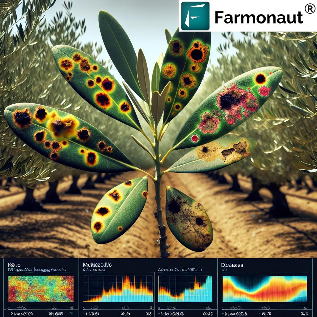
- Equipped with Advanced Sensors: Multispectral and hyperspectral imaging systems detect plant health patterns, while thermal cameras monitor moisture and irrigation issues. RGB cameras provide high-resolution visuals for mapping and documentation.
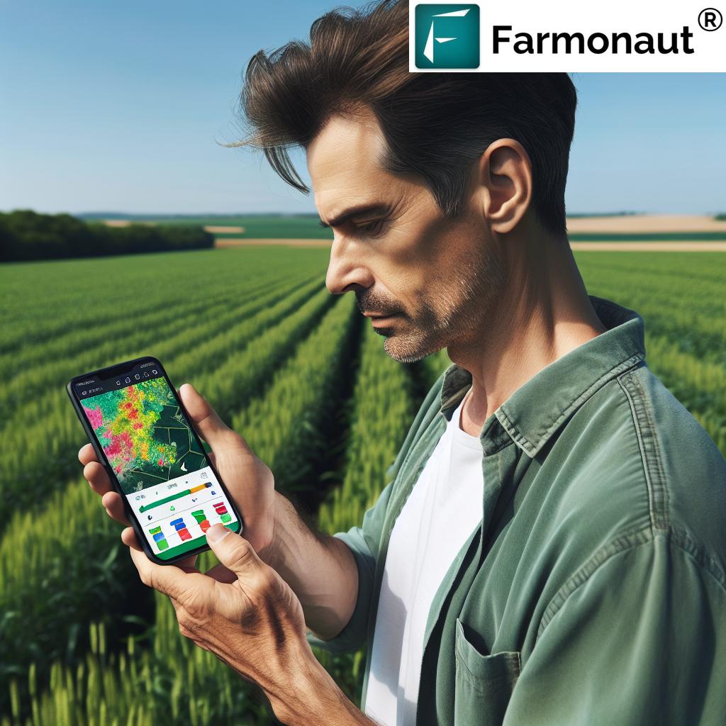
- Linked to Real-time Cloud Data Streams: UAV drones relay captured imagery and environmental data to the cloud for analysis, often integrating with weather, ground, and IoT sensor networks.
- Automated and GPS-Guided: Modern drones fly pre-programmed routes with remarkable precision, covering large fields and returning automatically after missions.
- AI and Machine Learning Enabled: Imagery is automatically analyzed to identify pest infestations, weed outbreaks, or nutrient deficiencies—insights that are delivered to farmers for immediate action.
A crucial factor in their effectiveness is the integration of UAV data with precision agriculture platforms, enabling informed decision-making on everything from input application to yield predictions.
Precision Agriculture UAV: From Data Capture to Decision
What differentiates precision agriculture UAV operations from traditional farming is the granularity, speed, and actionability of the data. Here’s how the cycle works in 2026:
- Aerial Data Capture: UAV drones fly over crops, capturing multispectral/thermal/RGB images that reveal plant health, moisture stress, pest and weed presence.
- Automated Analysis: AI algorithms scan captured imagery, detecting early signs of trouble such as nutrient deficiencies, disease outbreaks, or irrigation issues—often before they are visible to the naked eye.
- Informed Interventions: The platform recommends or triggers targeted actions: precision spraying of fertilizers/pesticides, variable-rate irrigation, or scheduling of field operations.
- Continuous Monitoring: Drones re-fly at scheduled intervals, providing updated insights, verifying interventions, and measuring impact on crop growth/yields.
The focus keyword “precision agriculture UAV” underscores how every step—from initial monitoring to timely interventions—is now guided by detailed, actionable data and AI-driven intelligence.
- Example Outputs: NDVI and other vegetation indices (assessing health), thermal maps (irrigation status), and digital elevation models (for optimizing water flow).
- Result: Up to 25% increase in yields, 30% reduction in input costs, and greater sustainability.
Want to combine UAV insights with broader datasets for holistic management? Discover Farmonaut’s Large Scale Farm Management tools, which pair UAV data with satellite monitoring for seamless planning and execution.
For the technical community, building your own UAV-integrated solutions is easier than ever. Explore the Farmonaut Satellite + Weather API and our Developer Docs for seamless integration.
AI & Automation: The 2026 Leap in Agriculture UAV Data Analysis
In 2026, agriculture UAVs are more than flying cameras—they are AI-driven data engines. The evolution of machine learning has powered a major leap forward:
- Automated Pattern Recognition: AI now automatically analyzes imagery for patterns linked to specific nutrient deficiencies, pests, or disease symptoms. This occurs in near-real time, enabling proactive interventions.
- Faster Response Times: UAV platforms instantly alert farmers and suggest remedies, slashing traditional scouting and response delays.
- Integrating Aerial & Ground Data: By combining UAV aerial data with IoT sensors (monitoring soil, irrigation, microclimate), and weather data, farmers get a holistic view of farm dynamics—and optimal input recommendation.
- Continuous Learning: Each flight and intervention adds new data to the system, fueling more accurate insights over time.
Integration with blockchain for traceability ensures full transparency from field to table. To strengthen your agri supply chain’s authenticity and consumer trust, explore Farmonaut Traceability solutions.
Sustainability, Environmental Impact & Regulatory Evolution
A crucial dimension of UAV use in agriculture is how drones are enabling more sustainable farming operations and meeting increasingly stringent regulations in 2026:
- Precision Input Application: Targeted spraying/fertilizing reduces runoff, pollution, and overall chemical use, supporting biodiversity conservation.
- Water Conservation: Drone-guided precision irrigation optimizes water resource management, especially vital amid climate variability.
- Early Pest Detection: Early aerial surveillance pinpoints pest outbreaks so farmers can utilize integrated pest management (IPM) methods, reducing blanket pesticide application.
- Transparency & Certification: Data captured by UAVs enables farmers to comply with and demonstrate adherence to standards for sustainability certifications.
- Regulatory Support: In 2026, regulatory frameworks in leading agri-economies have matured to facilitate safe drone operations—balancing innovation with privacy and airspace safety.
Environmental impact monitoring can be seamlessly integrated with UAV collected data for holistic sustainability KPIs. Discover Farmonaut Carbon Footprinting—a rapid, satellite-based tool for real-time emissions and resource use tracking.
Beyond Crops: Expanding UAV Drone Applications in Agriculture
UAVs in agriculture aren’t limited to row-crop monitoring. In 2026, drone agriculture solutions support a broad spectrum of applications:
- Orchards & Vineyards: Drones assess canopy health, monitor fruit development stages, and estimate optimal harvest windows.
- Reforestation & Plantation: Drones facilitate aerial seeding in challenging terrain, supporting sustainable land rehabilitation.
- Livestock Management: UAVs track herd movement, spot sick livestock earlier, and monitor grazing patterns to optimize rotational grazing.
- Infrastructure Mapping: UAVs create high-resolution maps for irrigation channel planning, fencing, and farm infrastructure development.
- Insurance & Lending Verification: Satellite and UAV imagery now provides verifiable evidence for crop loan and insurance claims. See Farmonaut’s Crop Loan and Insurance Tools for secure, affordable options.
- Fleet Management and Resource Use: Track equipment, optimize fleet operations, and reduce costs. Check out Farmonaut Fleet Management Suite to manage vehicles and machinery efficiently.
“By 2026, over 60% of large farms worldwide are projected to deploy UAVs for precision data collection.”
Challenges, Barriers, and the Future Outlook for UAVs in Agriculture
Despite the tremendous benefits, certain challenges still exist for broad UAV adoption in agriculture as we move into 2026 and beyond:
- Technical Skills Gap: UAV operations and data analysis require training. Efforts are underway globally to build up the required workforce skills.
- Connectivity Issues: Reliable internet is necessary for real-time data uploads and cloud analysis—still a barrier in some rural areas.
- Integration Complexities: Seamless merging of UAV and traditional farm management systems remains a technical and operational challenge.
- Weather Dependency: High winds, rain, or extreme weather can ground drones and impact scheduled operations.
- Data Privacy & Cybersecurity: Protecting farmers’ data and sensitive operational information is paramount. Secure systems and regulatory oversight continue to evolve.
- Cost Accessibility for Smallholders: Hardware costs continue to drop, but affordable UAV-as-a-service models and pooled resources are essential for small and medium farms to benefit.
Curious about adopting drones but want affordable, scalable, data-driven insights integrated with satellite monitoring? Our mission at Farmonaut is to enable this new precision era for all. Flexible subscription options are available for users of every size and sector, from individual smallholders to large enterprises and government agencies.
Farmonaut’s Role: Elevating Data Insights for Precision Agriculture
At Farmonaut, we are passionate about enabling farmers and agribusinesses worldwide to thrive in a data-driven, sustainable world. While our core solutions center on satellite-powered monitoring, resource management, and advisory systems, our platform seamlessly integrates with UAV data—offering holistic insights into crop health, soil conditions, irrigation, and environmental impact.
- AI-Powered Analysis: Our Jeevn AI delivers instant recommendations based on aerial and satellite data, supporting smarter interventions and higher yields.
- Resource & Environmental Management: Real-time dashboards, advanced analytics, and sustainability metrics help users optimize their land and operations.
- Scalable & Affordable: Whether addressing a 5-hectare farm or a 50,000-hectare commercial operation, our flexible subscriptions make advanced monitoring accessible for all.
- Blockchain-Enabled Traceability: We make it easy to build transparent, credible agri supply chains that open new markets and enhance consumer trust.
- Multi-Platform Access: Our solutions—accessible via web, Android, and iOS—bring the full power of AI and satellite insights into the field and boardroom.
If you’re interested in forestry or large-scale plantation management, our Crop Plantation & Forest Advisory solutions pair satellite insights with UAV data for end-to-end monitoring, promoting sustainability at scale. Discover Farmonaut’s Advisory Tools.
FAQ: Agriculture UAV & Precision Farming in 2026
What is an agriculture UAV and how is it used?
Agriculture UAVs are unmanned aerial vehicles equipped with cameras and sensors, used for real-time crop, soil, water, and pest monitoring. Their main advantage is enabling efficient data capture and precision interventions across large or hard-to-access areas.
How do UAV drones for agriculture improve crop yields?
By analyzing multispectral and thermal images, drones detect issues early—such as nutrient deficiencies or pest infestations—so targeted remedies can be applied, maximizing yields while reducing costs and environmental impact.
What types of data do agriculture UAVs collect?
UAVs capture NDVI and other vegetation indices, mosaic crop maps, thermal/IR images for water stress, RGB photos for visual analysis, and coverage reports for sprayed fields.
What are the challenges of UAV use in agriculture?
Challenges include training and skills gaps, rural connectivity limitations, weather disruption to drone flights, data privacy concerns, and cost barriers for smallholder farmers.
How can farmers get started with UAVs and data-driven farming?
Farmers can adopt UAV solutions via purchase, subscription, or UAV-as-a-service. Integration with satellite-based services like Farmonaut multiplies value, providing a holistic view of farm operations at affordable rates.
Do agriculture UAVs work with insurance and traceability?
Yes! UAV data provides verifiable evidence for insurance claims and enhances product and resource traceability, increasing access to financial services and export markets.
Is regulatory compliance still a concern for UAV adoption?
As of 2026, most countries have streamlined drone regulations, but compliance with airspace and data privacy laws remains important. Use only trusted, compliant providers and platforms.
Conclusion
Agriculture UAV technology stands at the forefront of the precision agriculture revolution in 2026 and beyond—enabling smarter, greener, maximally productive global farming. UAV drone agriculture platforms furnish granular, real-time insights into crop and soil conditions, automate input decisions, foster environmental stewardship, and support compliance with sustainable certification regimes.
As battery technology improves, costs continue to fall, and AI-driven automation advances, UAV adoption will only grow—transforming how food is produced, managed, and delivered worldwide.
At Farmonaut, we remain committed to empowering farmers with affordable, accessible, and scalable data solutions—from UAV integration to satellite-powered web and mobile apps, to blockchain-enabled traceability and resource management tools. The future of agriculture is here—let’s seize it together, ensuring food security and sustainability for generations to come.
Want to get started, scale, or integrate? Visit Farmonaut Satellite + Weather API and unlock the future of precision agriculture UAV data today.