
AI in Agriculture Images: Precision Farming in 2025
“By 2025, AI-powered imaging is projected to analyze over 80% of global farmland for crop health and sustainability.”
Introduction: The Revolution of AI and Imaging in Agriculture
As the global population continues to grow and climate change alters how traditional farming unfolds, the need for innovative, efficient, and sustainable practices in agriculture has never been greater. In recent years, the integration of advanced imaging technologies and artificial intelligence (AI) has revolutionized the agricultural field. What was once monitored purely by human eyes and manual inspections, now relies on automated systems translating agriculture images—captured via satellites, drones, and smartphones—into invaluable insights.
These images for agriculture are more than visual snapshots; they’re comprehensive data sources crucial for boosting crop health, monitoring land, optimizing resource use, and ensuring long-term sustainability. By 2025, AI in agriculture images stands at the forefront of precision farming, driving transformation for farmers, agronomists, and policymakers alike.

Understanding Agriculture Images: Types and Methods in 2025
Agriculture images in 2025 encompass a variety of sources and purposes. They include:
- Satellite Imagery: High-resolution, multi-spectral views from space, offering a comprehensive overview of vast agricultural areas.
- Drone Imagery: Detailed aerial images taken from low altitudes, enabling granular monitoring of small- to medium-scale fields.
- Smartphone & Camera Photos: On-the-ground images captured by farmers for real-time crop status, disease detection, or documentation.
- Multispectral and Hyperspectral Images: Revealing not only visible features but also moisture content, nutrient deficiencies, and plant stress through bands invisible to the human eye.
Methods for Utilizing These Images in Agriculture:
- Remote Sensing: Automated or periodic collection of images to monitor changes across seasons and years.
- Manual Inspections vs Automated Analysis: Traditional reliance on physical field inspections is rapidly being supplanted by AI-driven analysis.
- Geographic Information Systems (GIS) Integration: Images are mapped and layered with spatial data for detailed analysis and precision targeting of inputs.
By 2025, images for agriculture are indispensable in mapping soil types, identifying moisture levels, detecting pest infestations, and analyzing crop health. These methods dramatically enhance the accuracy and efficiency with which farmers monitor their fields.
Satellite and Drone Imagery: Transforming Land Monitoring
Satellite and drone imagery are redefining how agricultural land is monitored and managed. Unlike traditional methods that depend on sporadic manual checks, these technologies offer a comprehensive overview of vast farming areas, capturing agriculture land images at periodic intervals and different scales.
How Satellite Imagery Works in Agriculture
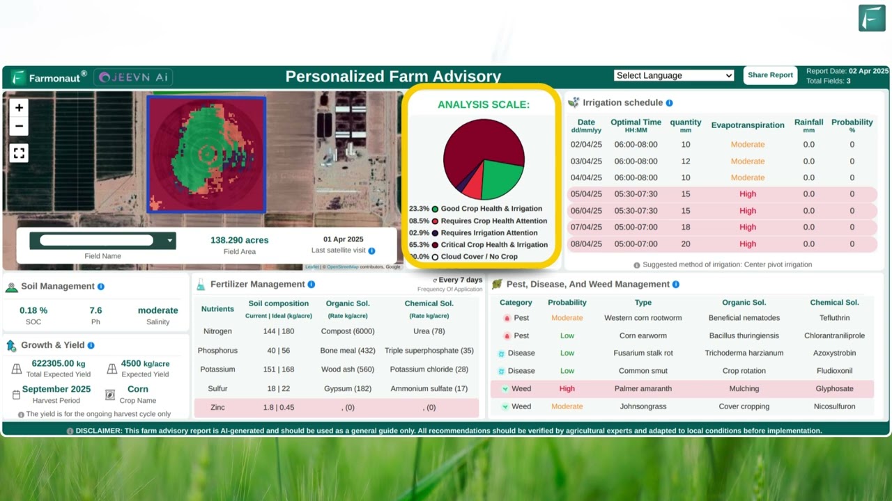
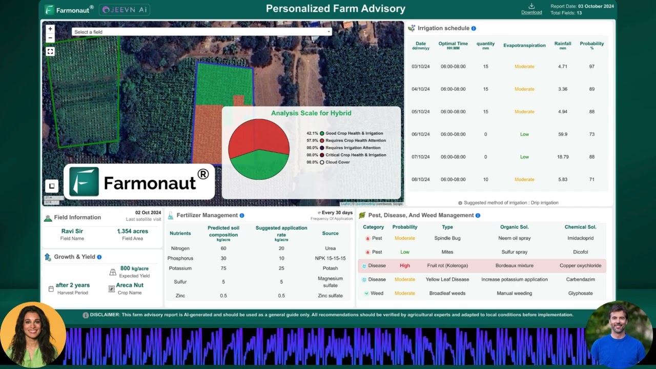
- Granular Mapping: Images enable the mapping of soil types, detecting moisture levels, identifying crop conditions, and even delineating field boundaries with unmatched accuracy.
- NDVI and Vegetation Health: Multispectral satellites analyze the Normalized Difference Vegetation Index (NDVI) to gauge plant health, identify stressed areas, and distinguish between healthy and unhealthy crops.
- Real-Time Monitoring: With frequent revisits by satellites, farmers access near-real-time updates on their fields, catching issues such as pest infestations or nutrient deficiencies early.
Drone Imagery in Precision Agriculture
- Field-Level Detail: Drones provide high-resolution, close-up images that reveal problems undetectable from satellites, such as localized disease outbreaks or irrigation breakdowns.
- Rapid Deployment: Quick and cost-effective deployment over targeted fields enables responsive agricultural management, especially when combined with AI-driven analysis.
This seamless integration of aerial imaging, automated mapping, and data analytics supports the shift toward precision agriculture—reducing waste, increasing yield, and targeting resources only where needed.
Discover how our satellite-based crop health monitoring can make a difference: Farmonaut Large Scale Farm Management

AI in Agriculture Images: From Data to Actionable Insights
In 2025, it’s not the sheer volume of agriculture images that matters most, but the ability to extract meaningful insights from those images—and that’s where AI in agriculture images comes into play.
How AI Processes Agriculture Images
- Pattern Recognition: Advanced algorithms parse through visual data, detecting early signs of disease, drought, stress, or nutrient shortages that are invisible to the naked eye.
- Classification and Differentiation: Machine learning models can instantly distinguish between healthy and unhealthy plants, identify crop types, and track growth stages.
- Prediction and Advisory: AI platforms can predict harvest times, forecast yield, and offer data-driven recommendations for resource allocation or pest management.
- Automation at Scale: AI processes vast numbers of images from multiple farms or regions, facilitating precision agriculture across diverse landscapes.
For example, Farmonaut’s Jeevn AI Advisory System evaluates satellite-derived imagery to deliver real-time insights and weather forecasts that support more informed, efficient, and sustainable crop management.
Integrate AI-based advice into your operations: Farmonaut Crop, Plantation & Forest Advisory
The Key Advantages of AI in Agriculture Imaging
- Timely, Granular Decision-making: Early identification of problems enables intervention before issues escalate.
- Efficient Resource Use: AI pinpoints exactly where to apply water, fertilizers, or pesticides, reducing costs and environmental impact.
- Scalable Solutions: Whether monitoring a single field or millions of hectares, AI-driven systems scale effortlessly.
“Advanced agricultural imaging can detect plant diseases with up to 95% accuracy, revolutionizing precision farming in 2025.”
Agriculture Farmer Images: Empowering Communities and Advisory Services
While much attention is given to satellite and drone imagery, the evolution of agriculture farmer images—photos and videos of farmers and their practices—is equally transformative in 2025.
Uses of Agriculture Farmer Images
- Knowledge Exchange: Photographs and visual documentation of on-field practices allow for rapid sharing of best practices among communities and extension workers.
- Training & Research: Video recordings help researchers and advisors demonstrate techniques, monitor labor patterns, or assess equipment use.
- Remote Advisory Services: Through AI-powered platforms, agriculture farmer images support real-time feedback, enabling expert consultancy even in remote areas.
- Data Collection: Visual data from farmers’ fields help AI models learn and improve, creating a positive feedback loop for future solutions.
These methods democratize knowledge and bridge the expertise gap, especially in regions where direct access to agronomists may be limited.
Comparative Impact: Traditional Farming vs AI Imaging (2025)
The shift from traditional farming methods to AI-driven imaging techniques brings distinct, quantifiable benefits. Here’s a comparative look at core factors shaping precision agriculture in 2025:
| Key Factor | Traditional Methods (Estimated 2024) | AI Imaging in 2025 (Estimated) |
|---|---|---|
| Crop Yield (tons/ha) | 2–3 | 3.5–5 (+50%↑) |
| Pest Detection Accuracy (%) | 60–70 | 90–95 (+35%↑) |
| Water Use Efficiency (%) | 30–50 | 70–85 (+70%↑) |
| Cost Savings ($/acre) | 0–50 | 80–120 (+100%↑) |
| Environmental Impact Reduction (%) | 5–10 | 25–40 (+300%↑) |
Estimated values based on current industry trends and projections. Actual results may vary based on local context and implementation.
Sustainability & Environmental Monitoring with Advanced Imaging
Today’s agriculture is inseparable from sustainability. As environmental concerns escalate and regulations toughen, advanced imaging technologies are at the vanguard of responsible land stewardship.
Key Roles of Imaging and AI in Sustainable Practices
- Continuous Monitoring: Satellites provide ongoing surveillance of land use changes, deforestation, and ecosystem health.
- Carbon Footprinting: By analyzing agriculture land images over time, stakeholders can track and reduce their carbon footprints efficiently.
- Transparency and Traceability: High-quality, AI-processed images provide critical data for transparent reporting to stakeholders, governments, and certification agencies.
- Resource Optimization: Imaging and AI reduce waste by precisely targeting resources (e.g., water, fertilizers, pesticides) only where absolutely needed.
Learn how you can monitor and cut your carbon footprint with satellite-based assessment: Farmonaut Carbon Footprinting Solution
The Role of Farmonaut: Satellite-Powered Precision for Agriculture
At Farmonaut, we are dedicated to making satellite-driven insights affordable and accessible for all stakeholders in agriculture. Our platform uses satellite-based monitoring, AI advisory systems, and blockchain-backed traceability to benefit individual farmers, businesses, and government bodies worldwide.
How Farmonaut Transforms Agriculture Images into Action
- Satellite Monitoring: We provide continuous observation of fields, detecting changes in crop health, soil moisture, pest infestations, and nutrient levels.
- AI-Based Advisory (Jeevn AI): Our AI analyzes massive amounts of imagery and weather data to produce actionable insights and timely recommendations for each field and farmer.
- Blockchain Traceability: We enable transparent, tamper-proof recording of every agricultural action, supporting supply chain verification and consumer trust.
- Environmental Monitoring: Our platform helps users track their carbon footprint and implement sustainability initiatives with reliable, AI-analyzed data.
- Fleet & Resource Management: We offer digital tools for monitoring farm machinery, reducing costs, and increasing resource efficiency.
Interested in transparent supply chains? Explore: Farmonaut Blockchain-based Traceability
Need data for loans or crop insurance? Read about: Farmonaut Crop Loan and Insurance Services
Our platform supports a scalable, data-driven approach, whether you’re a small farmer, a large enterprise, or a government policymaker.

Future Trends & Challenges in AI-Powered Agriculture Images
Trends Shaping 2025 and Beyond
- Hyperlocal Imaging: Proliferation of drones and micro-satellites means even the smallest farms will have access to high-frequency, high-resolution agriculture images.
- Integration with IoT: Imaging will merge seamlessly with data from soil sensors, weather stations, and farmer inputs, painting a richer mosaic of every field.
- Real-Time AI Insights: As 5G/6G and edge computing spread, turning image data into real-time, on-field decisions will become standard.
- Expanded Dataset Diversity: Growing open datasets and global image libraries will train more robust, resilient AI models applicable for any climate or crop type.
- Visual Advisory for Farmers: AI-generated visualizations will empower even non-technical farmers to make informed, precise adjustments to their practices.
Challenges Ahead
- Data Privacy: As more personal and land images are collected, there’s a greater need for secure storage and responsible usage policies.
- Digital Divide: Ensuring all farmers—including those in remote regions—have affordable access to these advanced technologies is crucial.
- Scalability of AI: Processing images globally requires scalable, efficient, and adaptive AI systems.
- Environmental Cost of Technology: The satellite and drone industry must ensure technology deployment doesn’t inadvertently add to the global carbon footprint.
Find out about our solutions for managing large-scale operations: Farmonaut Large Scale Farm Management
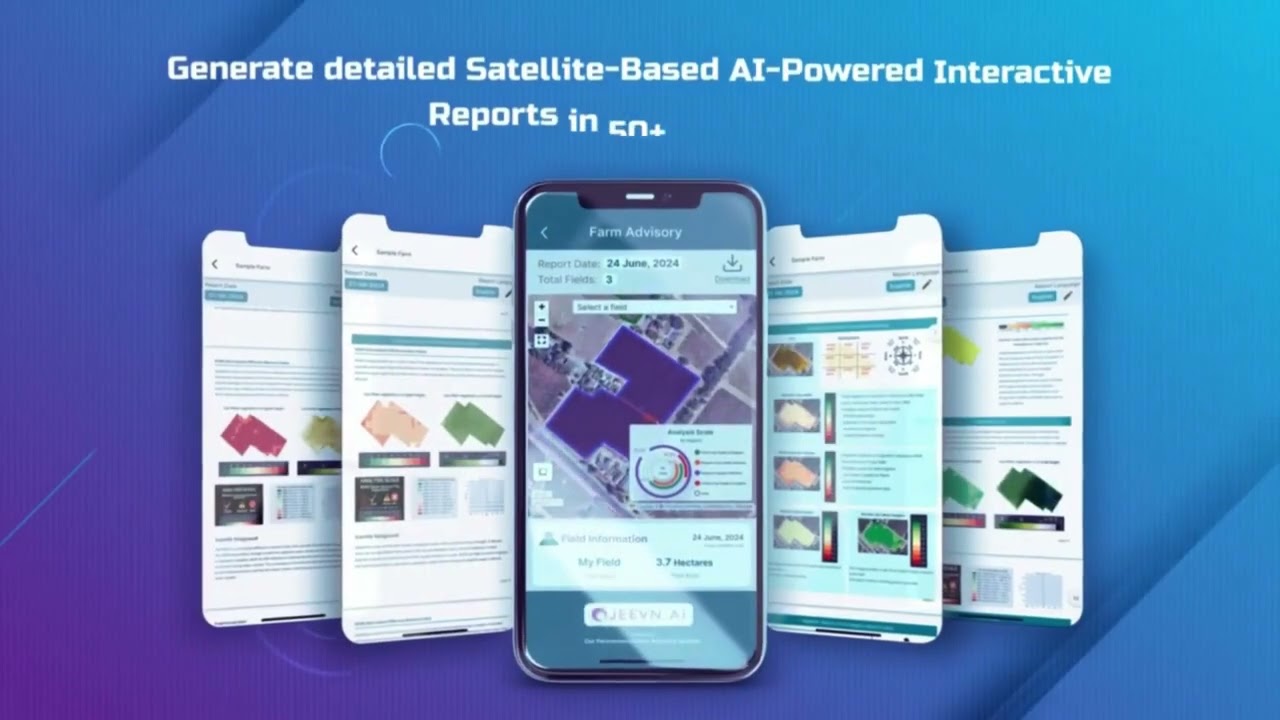
Farmonaut Apps, APIs & Subscriptions: Making Data Accessible
At Farmonaut, we’re passionate about equipping every stakeholder in the agricultural supply chain with easy, secure access to high-quality agriculture images and AI-driven insights.
-
Mobile & Web Apps: Access satellite-based monitoring, advisory, and environmental tools on Android, iOS, or the web.


Easily monitor your fields, receive AI-based recommendations, and optimize your resource use anytime, anywhere. - APIs for Developers: Seamlessly integrate satellite and AI-powered agriculture image data into your own systems using:
-
Flexible Pricing & Subscriptions:
- Choose plans for individuals, businesses, or governments to match your scale and needs.
-
See our pricing options below:
- Fleet Management: Optimize your farm vehicles, minimize downtime, and reduce operational costs with Farmonaut Fleet Management.
Frequently Asked Questions (FAQ)
What are agriculture images and why are they important?
Agriculture images encompass photos, satellite and drone imagery showing farmlands, crop health, soil conditions, and farming practices. They provide critical data for informed decision-making, improving resource use, and boosting productivity.
How does AI in agriculture images work?
AI in agriculture images uses machine learning and pattern recognition to interpret massive amounts of visual data. AI models detect early signs of crop stress, classify plant health, and predict optimal times for intervention or harvest.
How are satellite and drone images used in precision farming?
Satellite and drone images offer comprehensive, multi-scale monitoring of farm fields. Through GIS and AI analysis, these images enable precise application of water, fertilizers, and pesticides only where needed, reducing waste and maximizing yields.
What role do agriculture farmer images play?
Agriculture farmer images—photos or videos of farming practices—facilitate knowledge sharing, training, and research. With AI, they also support remote advisory services and the development of improved agronomic models.
Can Farmonaut help me monitor my fields remotely?
Absolutely! Our platform allows you to monitor crop health, soil conditions, and environmental impact remotely through satellite-based imagery and AI-driven analytics. Check our web and mobile apps for more.
Conclusion: Shaping the Future of Agriculture with AI Imaging
By 2025, the convergence of advanced imaging technologies and artificial intelligence is not just transforming—but truly revolutionizing—the practice of agriculture. Agriculture images have evolved from static pictures to dynamic, data-rich assets driving resource efficiency, boosting yields, and supporting sustainability at every scale.
Our ability to monitor fields remotely, detect early signs of disease, and provide actionable insights ensures every decision is smarter and more sustainable. At Farmonaut, we are proud to be at the heart of this transformation, making precision farming affordable and accessible globally—benefiting individual farmers, enterprises, and governments.
Embrace the power of AI in agriculture images—and join us in building a future where agriculture is more precise, resilient, and sustainable than ever before.
Ready to experience the future of farming? Get started with Farmonaut today.


