
Classify Plantations Using Farmonaut: 7 Key Insights
Meta description: Classify plantations using Farmonaut’s advanced satellite-based monitoring. Discover 7 key insights for crop health assessment, yield optimization, and sustainable plantation management.
In the swiftly evolving landscape of agriculture, the pursuit of higher productivity, sustainability, and profitability steers us toward adopting innovative approaches and advanced technologies. At the heart of this agricultural revolution, Farmonaut emerges as a pioneering agritech company—transforming plantation classification, field monitoring, and crop health assessment through powerful satellite-based monitoring and AI-driven data analytics.
As the global demand for food and raw materials intensifies, farmers and plantation managers need actionable insights for yield optimization in plantations and sustainable plantation management. This comprehensive guide explores Farmonaut’s unique strengths in classifying and monitoring plantations, while showcasing 7 key insights that set our advanced plantation classification using remote sensing apart.

Summary: Precision farming is no longer a privilege reserved for select large estates. Farmonaut’s technology democratizes access to advanced, satellite-driven plantation classification—empowering farmers, agribusinesses, and governments worldwide. From tree counting and density estimation to early detection of crop diseases, automated resource tracking, and sustainable practices, Farmonaut bridges the gap between tradition and technology for a smarter, greener future.
7 Key Insights: Satellite-Based Plantation Classification with Farmonaut
Here’s what you’ll learn in this in-depth blog:
- Tree Counting and Density Estimation
- Age Estimation via Canopy and Growth Analysis
- Crop Health Assessment Using Vegetation Indices
- Area Mapping and Delineation
- Integration with Multiple Data Sources
- Customized, Actionable Insights for Management
- User-Friendly Interface and Continuous Monitoring
Let’s explore these insights, how they drive real value, and why Farmonaut stands at the forefront of technological innovation in plantation management.

Satellite-Based Plantation Monitoring & Classification: The Farmonaut Approach
Satellite-based monitoring lies at the heart of next-generation plantation management. By harnessing high-resolution satellite imagery, Farmonaut enables continuous surveillance and real-time classification of plantations, paired with actionable data-driven insights.
- Remote Sensing: Multispectral satellite images (e.g., Sentinel-2, Landsat-8) provide a birds-eye view across vast areas, capturing crucial aspects such as crop vigor, canopy development, soil moisture, and changes in field boundaries.
- Artificial Intelligence & Algorithms: Advanced object detection algorithms process complex imagery to classify fields, count individual trees, and analyze growth patterns—far surpassing manual field surveys in efficiency and accuracy.
- Real-Time Data: Our platform delivers near real-time monitoring, facilitating timely interventions in case of stress, pest issues, or diseases.
Why plantation classification using remote sensing?
Traditional techniques—like field scouting—are labor-intensive, time-consuming, and spatially limited. Satellite-based classification brings precision, scale, and speed, enabling:
- Optimization of plantation management strategies
- Early detection of crop diseases, stress factors, and anomalies
- Improved resource allocation for plantations
- Efficient planning for harvesting, irrigation, and fertilization cycles

Key Features of Farmonaut’s Plantation Classification
Through our satellite-based monitoring, Farmonaut empowers farmers and plantation managers with holistic, actionable data. Here’s a deep dive into the seven key features that redefine plantation classification, boosting productivity, sustainability, and risk mitigation:
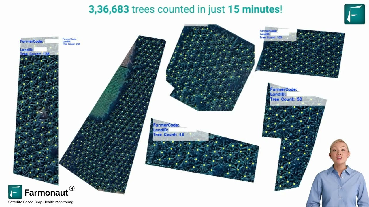
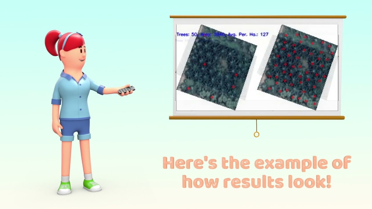
1. Tree Counting and Density Estimation
- Object Detection Algorithms: Using AI-powered models, Farmonaut accurately counts individual trees within plantations, regardless of area size or shape.
- Benefits:
- Assists in assessing planting density and optimizing space utilization
- Identifies underutilized areas for targeted planting or intercropping
- Highlights missed spots or overlaps, informing replanting and gap-filling strategies
2. Age Estimation via Canopy and Growth Pattern Analysis
- Growth & Canopy Development: Our technology analyzes canopy patterns and morphological changes over time to estimate the age of plantation trees (read more).
- Benefits:
- Aids in planning harvesting schedules and resource allocation
- Supports long-term plantation lifecycle management
- Allows for strategic input application based on tree maturity
3. Crop Health Assessment Using Vegetation Indices (NDVI, EVI, etc.)
- Health Detection: Satellite-derived indices—most notably, Normalized Difference Vegetation Index (NDVI)—evaluate plantation health at both individual and plot level.
- Early Detection:
- Enables early detection of diseases, pest infestations, and environmental stressors
- Supports timely interventions before issues affect quality or yield
- Monitors effectiveness of interventions post-application
Tip: NDVI values range from -1.0 (no vegetation) to +1.0 (dense healthy vegetation); lower NDVI often signals crop stress, requiring instant action.

Monitor your plantations in real time and receive NDVI-based crop health reports instantly: Farmonaut Crop Health Monitoring Tool
4. Area Detection and Mapping
- Our platform accurately maps plantation areas using GPS coordinates and satellite data, marking precise field boundaries (learn more).
- Benefits:
- Facilitates resource allocation for plantations—water, fertilizers, labor
- Improves planning of operational strategies for large-scale farms
- Vital for audit trails and compliance in sustainability certifications
5. Integration of Multiple Data Sources
- Farmonaut enhances classification accuracy by combining satellite data with:
- Historical yield information
- Weather patterns
- Detailed soil maps
- Operational field data (manual observations, IoT sensors)
- Benefits:
- Builds a comprehensive picture of plantation dynamics
- Drives data-driven decisions for sustainable plantation management
- Enables precision agriculture technologies at scale
API access for integration: Add real-time satellite and weather data to your agri-apps and research management systems via our Farmonaut API (API Developer Docs).

6. Customized, Actionable Insights for Plantation Management
- Our platform delivers customized recommendations engineered for each unique plantation:
- Optimal Crop Selection—Suggests best options by analyzing soil type, climate, and historical performance
- Efficient Resource Allocation—Pinpoints areas needing irrigation, fertilizers, or pesticides for cost savings
- Sustainable Practices—Promotes implementing approaches that preserve soil health and ecosystem balance
Benefit: Customized insights reduce input waste, improve yields, and minimize environmental footprint—fundamental for certified sustainable plantations.


7. User-Friendly Interface and Continuous Monitoring
- Our farm management solution is accessible via web, Android, and iOS platforms, and API (try now).
- Intuitive dashboard allows users to view multi-temporal satellite data, monitor health trends, track interventions, and generate reports on the go—enabling managers to monitor and respond remotely 24/7.
- Automated notifications for stress, disease, or anomalies enable prompt action.
Accessibility + Simplicity = Empowered Decision-Making, Even in Remote Areas!
Calculate and Monitor Your Plantation’s Carbon Footprint for Sustainable Certification
Feature Comparison Table: The 7 Key Insights in Satellite-Based Plantation Classification
| Insight | Satellite Technology Used | Key Data Indicators | Primary Application | Estimated Accuracy (%) | Potential Impact |
|---|---|---|---|---|---|
| Tree Counting & Density Estimation | Sentinel-2, Landsat-8 (multispectral) | Object detection, spatial density | Gap analysis, replanting, land use | 92–97% | Resource optimization, increased yield potential |
| Age Estimation | Sentinel-2 | Canopy width, historical data | Harvest planning, asset valuation | 85–92% | Optimized planning, reduced labor |
| Health Assessment (NDVI/EVI analysis) | Sentinel-2, Landsat-8 | NDVI, EVI, color composites | Early disease/pest detection | 89–96% | Yield protection, risk mitigation |
| Area Mapping & Delineation | All major satellite sources | Vector boundaries, GPS overlays | Compliance, input calculation | 99%+ | Cost reduction, efficient logistics |
| Integration of Data Sources | Remote sensing, met data, ground sensors | Weather, yield, soil data | Scenario forecasting, multi-factor analysis | 85–97% | Informed decisions, holistic management |
| Customized Recommendations | Fusion (satellite, AI, user input) | Tailored insight metrics | Plantation-specific action planning | ~96% | Yield increase, cost savings |
| Continuous Monitoring Interface | Live satellite, web/mobile access | Dashboards, alert systems | Smart intervention tracking, mobile alerts | 95–99% | 24/7 awareness, rapid response, digital record-keeping |
Access our advanced crop & plantation monitoring dashboard instantly via browser or app: Click here
Integration of Multiple Data Sources: A Comprehensive Approach
Relying solely on images is never enough. Farmonaut integrates satellite data with an array of additional sources—from weather and soil maps to yield statistics and historical interventions. The result? Layered, holistic plantation intelligence that delivers:
- Greater Data Accuracy: Cross-referencing and validation between remote sensing, sensor data, and manual entries
- High-Resolution Analysis: Combines big-picture trends with granular plot-level details
- Disease Outbreak Prevention: Identifies cause-and-effect (e.g., correlating soil moisture anomalies with disease patterns for early alerts)
- Actionable Alerts: Enables plantation managers to act proactively—instead of reactively—on emerging threats or opportunities
Integration unleashes the full power of precision agriculture technologies, building a digital backbone for sustainable plantation management.
Customized Insights for Plantation Management: Empowering Data-Driven Decisions
Every plantation is unique—in its crops, soil type, microclimate, and historic yield dynamics. That’s why Farmonaut provides customized insights and action plans, such as:
-
Targeted Interventions, Not Blanket Approaches:
- Pinpoint exactly which areas (plots, blocks, or even individual trees) need irrigation, fertilizer, or pest control
- Act on real-time evidence—reducing input costs, labor, and environmental pollution
-
Optimal Crop Selection:
- Advisory on best-fit crops/cultivars for your soil and weather
- Enables forecasts for yield optimization in plantations
-
Sustainable Resource Management:
- Guidance on rotation, fallowing, and intercropping for maintaining soil vitality and biodiversity
Result: Smarter resource allocation for plantations, optimized yields, and improved long-term profitability.
Explore Adaptive Plantation Advisory Tools for Crop & Forest Monitoring
The Farmonaut Platform: User-Friendly Interface & Continuous Monitoring
Digital transformation only unlocks value when it’s accessible to every grower and agribusiness. That’s why we’ve designed our platform to be:
- Intuitive: Minimal training needed, with interactive dashboards, alarms, maps, and reports
- Accessible: Log in through web browser, Android/iOS app, or API, anytime and anywhere—whether you manage hundreds of acres or a smallholder plot
- Multilingual Options: Supporting farmers across India and globally for maximum inclusivity
- Mobile Responsive: All dashboards and maps adjust smoothly to phone or tablet for field operations
Ready to take plantation monitoring mobile?
Download our mobile app for Android or iOS now! Or use our Large Scale Plantation Management Dashboard for end-to-end digital supervision of vast land holdings.
Future Prospects & Technological Advancements in Plantation Classification
We continuously innovate for the future of agriculture. Our roadmap includes:
- Advanced Predictive Analytics: Machine learning models to forecast yield trends, disease outbreaks, and optimal harvesting times
- Integration with IoT and Drones: Fusing satellite data with sensors and drone imagery for unparalleled field-level precision and on-demand verification
- Automated Systems: AI-driven, automated irrigation, pest control, and harvesting systems—all triggered by real-time satellite and sensor data
- Blockchain for Traceability: Ensuring transparent, tamper-proof supply chains where every input, output, and harvesting detail is verifiable
Learn How Blockchain Traceability Secures Your Plantation’s Value Chain.
Need satellite-based documentation for crop loans and insurance? Satellite Verification for Crop Loan & Insurance ensures transparency and fraud reduction for both farmers and financial institutions.
Farmonaut Subscription Options
Our subscription model is tailored for individual farmers, cooperatives, agribusinesses, and public sector users. You only pay for the acreage and update frequency you need—making sustainable precision agriculture affordable and scalable, without any expensive hardware.
Contact us for customized enterprise plans and integration support for large-scale farm monitoring!
Frequently Asked Questions (FAQ) about Plantation Classification with Farmonaut
What is satellite-based plantation monitoring?
Satellite-based plantation monitoring is the use of high-resolution satellite images and AI algorithms to observe, analyze, and classify plantations at scale. This includes real-time assessment of crop health, tree density, soil moisture levels, and boundary mapping—empowering farmers and managers to make data-driven decisions for yield, sustainability, and efficient resource use.
How does tree counting and density estimation work in Farmonaut?
Farmonaut employs sophisticated object detection algorithms on satellite imagery to accurately count individual trees, calculate planting density, and highlight areas for improvement. This enables replanting in gaps, optimizing space usage, and assessing canopy uniformity for long-term planning.
What is NDVI and why is it important for crop health assessment?
NDVI (Normalized Difference Vegetation Index) is a spectral measurement derived from satellite images, reflecting the greenness and vigor of vegetation. High NDVI values indicate healthy, photosynthetically active crops, while low values signal stress, disease, or inadequate resources. This index is crucial for early detection of problems and precision interventions.
Can Farmonaut’s plantation classification platform be used on mobile devices?
Yes! Farmonaut offers a seamless user experience across web, Android, and iOS devices, allowing plantation monitoring and management updates from anywhere. The interface is optimized for both desktop and mobile responsiveness.
What are the sustainability benefits of using Farmonaut?
Farmonaut’s accurate classification and health monitoring lead to reduced usage of fertilizers and pesticides, improved water management, and minimized environmental impacts. The integrated carbon footprint tracking feature supports sustainability goals, while blockchain traceability ensures ethical supply chain transparency.
How can I integrate Farmonaut’s satellite data with my own agri-business platform?
Our developer-friendly API and detailed API docs make it easy to connect Farmonaut’s satellite and weather feed with your custom software or business applications.
Does Farmonaut’s solution require any special hardware or devices?
No. All Farmonaut solutions leverage remote sensing, AI, and cloud-based processing, delivering results via web/mobile platforms. No additional drones, sensors, or hardware are required for the core features.
Conclusion: Why Choose Farmonaut for Advanced Plantation Classification?
The future of plantation management is a blend of technology, data, and sustainability. By leveraging satellite-based monitoring, AI-driven classification, and integrated insights, Farmonaut empowers agricultural stakeholders to achieve unmatched levels of productivity, cost efficiency, and risk mitigation—while meeting the evolving demands of sustainability and traceability.
- Accurate Plantation Classification: Achieve real-time crop health assessment and tree-level analytics.
- Proactive Management: Spot issues early and implement targeted interventions for maximum yield and minimum loss.
- Resource & Cost Savings: Reduce fertilizer, pesticide, and water wastage by acting only where needed—backed by precise data.
- Scalable & User-Friendly: Accessible via browser, apps, and APIs; suitable for everyone from smallholders to large enterprises.
- Sustainability Built-In: Features like carbon monitoring and blockchain traceability future-proof your operations and strengthen your supply chain credibility.
From tree counting and density estimation to yield optimization in plantations and sustainable plantation management, Farmonaut is your trusted partner for achieving smarter, greener, and more profitable plantations—worldwide.


