Regulatory Compliance in Oilfields: InSAR for Transparency
Meta Description: Regulatory Compliance in Oilfields: How InSAR Supports Transparency—Explore how cutting-edge satellite radar technology provides accurate, transparent environmental monitoring for oilfields in 2025.
“Over 90% of oilfield regulatory violations are linked to undetected ground movement—InSAR detects shifts as small as 1 millimeter.”
Introduction: Regulatory Compliance in Oilfields — 2025 Landscape
The oil and gas industry continues to be a vital component of the global energy landscape in 2025, powering economies and supporting industrial development. Yet, the sector remains under intense scrutiny regarding environmental and safety compliance. More than ever, oilfield operations face stringent regulatory frameworks designed to minimize impacts, prevent land subsidence, and ensure community safety.
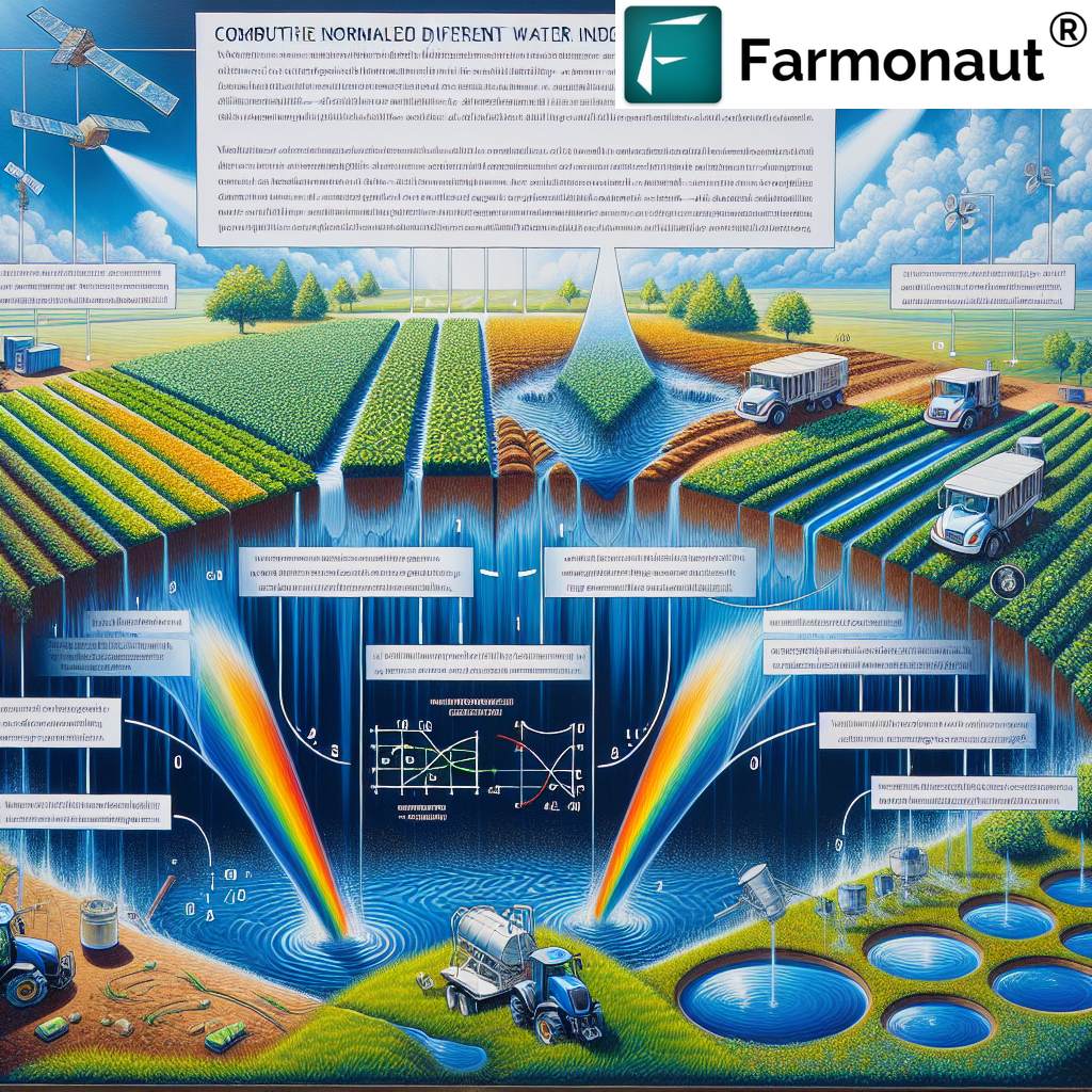
Innovations in technology have brought new solutions to these age-old challenges. Chief among them is Interferometric Synthetic Aperture Radar (InSAR), a powerful tool for transparent, accurate monitoring of ground deformation induced by oil extraction or injection processes.
This comprehensive blog explores Regulatory Compliance in Oilfields: How InSAR Supports Transparency, highlighting the advantages of satellite-based monitoring and the transformative role of advanced platforms like Farmonaut in making these solutions accessible for the industry, regulators, and communities.
Understanding InSAR Technology: From Space to Oilfield Ground
What is InSAR?
Interferometric Synthetic Aperture Radar (InSAR) is a satellite-based technology that uses radar signals to measure ground displacement with extraordinary accuracy. Through comparing radar images of the same area acquired at different times, InSAR generates deformation maps that reveal subtle changes—often as small as 1 millimeter—in the earth’s surface.
- Non-invasive: InSAR requires no physical contact with the ground, making it ideal for continuous, broad–coverage monitoring.
- Wide-area capability: Can cover areas exceeding 10,000 square kilometers in a single satellite pass.
- High-frequency revisit: Modern satellites deliver near real time data (as often as every few hours).
- High-resolution: Pinpoints deformation at the millimeter scale, critical for detecting early signs of subsidence or uplift in oilfields.
By leveraging the interference pattern between radar waves reflected from the ground at different dates, InSAR offers accurate documentation of ground movements associated with oil extraction, water/CO₂ injection, and other subsurface activities.
“InSAR technology enables continuous monitoring of oilfields across areas exceeding 10,000 square kilometers, ensuring regulatory transparency.”
Key Working Principles of InSAR
- A satellite equipped with a synthetic aperture radar sensor scans the surface and records reflected radar signals.
- At a later date, the satellite scans the same area.
- The differences (interference) between the radar signals are analyzed to calculate land displacement or deformations between the two dates.
- This analysis generates a detailed map of ground movement (subsidence, uplift, etc.) throughout the oilfield lifecycle.
With these capabilities, InSAR is an ideal tool for regulators, operators, and stakeholders seeking compliance with rigorous environmental standards in oilfields.
Oilfields & Regulatory Frameworks: Why Monitoring is Critical
Complex Operations Under Intense Scrutiny
Oil and gas extraction involve complex subsurface activities with extensive surface footprints. These operations can induce ground movements (subsidence or uplift) due to the removal or injection of fluids underground. As a result, oilfields face intense regulatory scrutiny to:
- Minimize environmental impacts: Prevent damage to ecosystems, habitats, soil stability, and water resources.
- Protect communities: Avoid infrastructure failure (pipelines, roads, buildings) caused by subsidence.
- Ensure safety: Address risks to both workers and the public posed by ground deformation.
- Deliver transparent reporting: Regulators worldwide impose requirements for continuous monitoring, data reporting, and auditability.
Key Regulatory Requirements in 2025:
- Continuous monitoring of subsurface-induced deformations
- Periodic, standardized reporting to regulatory agencies
- Instant anomaly detection and risk notifications
- Post-closure land stability assessments
- Demonstrable compliance with reclamation and restoration standards
Failure to detect and report deformation can result in regulatory violations, penalties, operational shutdowns, and significant reputational damage.
Challenges of Traditional Monitoring Methods
- Manual inspections: Costly, time-consuming, and often dependent on subjective interpretation.
- Ground-based GPS stations & leveling surveys: Provide only point-based data, geographically limited, difficult to scale to large areas.
- Delayed detection: Physical changes are often identified only after significant damage or risk exposure.
Hence, 2025 is witnessing a surge in adoption of InSAR technology by oil companies looking to meet evolving regulatory standards and public expectations for transparency.
InSAR for Risk Minimization: Detecting Deformation and Subsidence
How InSAR Helps Prevent Environmental and Infrastructure Risk
Regulatory Compliance in Oilfields: How InSAR Supports Transparency revolves around the core ability of InSAR to:
- Provide continuous, large-area ground monitoring
- Detect subtle, early-stage deformations linked to oilfield activity
- Enable predictive risk management by alerting operators and regulators to emerging patterns of ground movement
These abilities are mission-critical because ground subsidence and uplift can:
- Destabilize oilfield infrastructure (pipelines, tanks, rigs)
- Compromise community buildings, roads, and utilities nearby
- Affect drainage patterns, leading to environmental degradation
- Trigger regulatory intervention and potential shut-downs
Key Example Risks Monitored By InSAR:
- Oil extraction-induced subsidence: Gradual sinking of land surface after removal of fluids.
- Water/CO₂ injection uplift: Swelling or heaving of the earth’s crust after fluid injection, which can precede leaks or ruptures.
- Fissuring and fault reactivation: Distant but subtle shifts exposing hidden hazards.
When detected early via InSAR, these risks can be mitigated before causing damage—a key focus of regulatory compliance in oilfields for 2025 and beyond.


Tap into affordable, real-time satellite monitoring for oilfield compliance using the Farmonaut Platform—on web, Android, or iOS!
Developers can integrate high-accuracy ground deformation data directly into existing systems. Explore the Farmonaut API and API Developer Docs.
Key Benefits of InSAR in Oilfield Regulatory Compliance
Why InSAR Is Transforming Oilfield Monitoring in 2025
- Extreme accuracy: Detects subsidence or uplift as small as 1 mm, improving risk forecasting.
- Continuous, automated data collection: No need for manual/field interventions over vast and remote areas.
- Wide coverage: Seamless monitoring over entire oilfields (surface footprints up to tens of thousands of square kilometers).
- Non-invasive and safe: No disruption to operations or the community.
- Transparent and verifiable: Data can be independently validated; vital for regulatory audits and reporting.
- Actionable insights: Early warning for operators to intervene before critical failures or compliance breaches.
- Supports evolving frameworks: Aligns with global regulatory trends for risk-based monitoring.
Unlike traditional methods (manual inspection, sparse GPS, or leveling surveys), InSAR supports oilfield operators and regulators in achieving full lifecycle compliance—from new development to decommissioning and post-closure stewardship.
How InSAR Integrates With Regulatory Reporting & Community Transparency
- Meets strict regulatory requirements: Continuous, auditable record of ground deformation.
- Supports transparent public disclosure: Oilfield stakeholders (including communities and NGOs) access monitoring results, fostering trust and mitigating misinformation.
- Enables collaborative risk mitigation: All parties work from shared, credible datasets—preventing disputes and supporting adaptive management.
As regulatory expectations rise worldwide for the oil & gas sector, Regulatory Compliance in Oilfields: How InSAR Supports Transparency remains a central theme for operators navigating the future of sustainable resource management.
Enhancing Monitoring, Reporting & Stakeholder Transparency
Transparent, Real-Time Data for Oilfield Stakeholders
By offering near-instantaneous, detailed maps of ground movement, InSAR enables operators, regulators, and communities to:
- Track spatial and temporal patterns: Analyze long-term ground stability and identify high-risk zones.
- Prove compliance: Provide objective evidence for meeting environmental and safety regulations.
- Facilitate open communication: Publish results via cloud-based or secure portals for stakeholder access.
This unprecedented data transparency supports trust between operators, regulators, and local communities.
InSAR-Driven Regulatory Reporting
- Standardized, automated reporting templates for regulators
- Audit-friendly data archives—allowing independent validation at any time
- Geospatial analytics—linking deformation to specific oilfield activities, infrastructure, or injection/extraction zones
InSAR-based compliance monitoring is rapidly becoming a central pillar of risk management strategies for ambitious oilfield operators.
Comparative Benefits Table: Traditional vs. InSAR-Enabled Compliance
This comparative table summarizes how “InSAR for oilfield compliance” delivers major improvements over conventional monitoring methods, supporting regulatory transparency and risk reduction.
| Compliance Aspect | Traditional Method | InSAR-Enabled Method | Estimated Improvement (%) |
|---|---|---|---|
| Environmental Monitoring | Manual inspection & ground-based sensors; limited area coverage; moderate detection | Satellite-wide, high-frequency monitoring; mm-scale accuracy; automatic anomaly alerts | +60% |
| Risk Detection & Response | Periodic, reactive; delayed detection after visible damage | Near real-time, predictive risk alerts; early intervention enabled | +50% |
| Reporting Transparency | Manual reporting, fragmented data, subjective interpretation, limited auditability | Standardized digital reports; objective data; full audit trail; remote access | +35% |
| Regulatory Audit Readiness | Historical records often incomplete or non-verifiable | Continuous, automated record-keeping with secure timestamps | +70% |
| Operational Cost Efficiency | Field staff, equipment, and travel required—costly to scale | Remote, routine monitoring; minimal field presence; affordable at scale | +45% |
Farmonaut: Making Advanced Satellite Monitoring Accessible
Our Commitment: Democratizing InSAR for Oil & Gas Compliance
At Farmonaut, we harness satellite technology—combining advanced remote sensing, AI, and machine learning—to empower oilfield operators, regulators, and decision-makers with actionable insights. Our mission is to make satellite-driven ground deformation tracking affordable, transparent, and accessible for organizations of every scale.
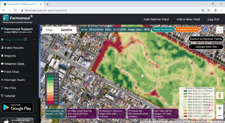
- Real-time Monitoring: Our platform enables users to monitor large oilfields seamlessly—detecting changes as small as 1 mm using InSAR-derived data.
- Automated, Digital Reporting: Streamlines compliance obligations, using standardized templates exportable for regulatory submission.
- Environmental Impact Tracking: We offer real-time analytics to monitor and verify land condition pre, during, and post-operations.
- Blockchain Traceability: Our traceability tools secure monitoring records and foster trust across every stakeholder, from operators to regulators and the community.
Learn more about our blockchain-based traceability solutions here. - Scalable API Access: API integration is available for resource management and compliance teams.
- Accessible Anywhere: Use our web & mobile apps to access deformation maps, monitoring analytics, and compliance dashboards from the office or field.
We take pride in supporting effective, transparent regulatory compliance for oilfield operations worldwide—enabling sustainable energy development that respects community and environmental standards.
Our Carbon Footprinting service helps oilfield operators quantify and report their environmental impact, ensuring alignment with global ESG and regulatory standards alongside InSAR compliance monitoring.
Future Trends: InSAR for Oilfield Compliance in 2025 & Beyond
Emerging Innovations
As we look towards 2025 and beyond, several transformative trends will further enhance Regulatory Compliance in Oilfields: How InSAR Supports Transparency:
- Higher revisit rates: New satellite constellations (e.g., smallsats, mega-constellations) enable more frequent updates, shrinking the window between risk development and detection.
- Greater resolution: Improved sensor technology pushes detection to sub-millimeter thresholds—delivering early warning systems for even the smallest subsidence or uplift events.
- Artificial intelligence: AI-driven analytics accelerate anomaly recognition and automated compliance reporting for stakeholders.
- Data fusion: Integrating InSAR with multispectral, hyperspectral, lidar, and IoT data gives a 360-degree view of oilfield environment, infrastructure, and emissions.
Explore environmental impact analytics for oilfields here. - Open-access dashboards: Platforms like Farmonaut provide secure, role-based access for real-time monitoring—boosting stakeholder engagement and accountability.
- Post-closure monitoring: Regulators are increasingly demanding evidence of long-term land recovery after well abandonment. InSAR enables objective verification of post-closure stability and restoration.
These advancements position InSAR-based monitoring as indispensable for regulatory compliance in the oil & gas sector, supporting the industry’s transition toward sustainable, responsible development.
For oilfields integrating agriculture or carbon offset projects, our Crop & Forest Advisory tools offer additional, satellite-powered environmental analyses.
FAQ: Regulatory Compliance in Oilfields – InSAR Insights
What is InSAR, and why is it crucial for oilfield regulatory compliance?
InSAR stands for Interferometric Synthetic Aperture Radar. It’s a satellite technology that measures ground deformation at millimeter accuracy. In oilfields, it enables continuous, non-invasive tracking of land subsidence/uplift, supporting compliance with strict environmental and safety standards.
How does InSAR enhance transparency for oilfield stakeholders?
InSAR provides objective, independently verifiable datasets on ground movement, which can be accessed by operators, regulators, communities, and environmental groups. This open data sharing reduces misinformation and builds trust.
Can InSAR replace traditional ground monitoring methods completely?
InSAR is best used alongside, or as a modern alternative to, traditional methods (like GPS and manual surface surveys). It dramatically improves coverage, accuracy, and the ability to automate compliance workflows.
What kinds of regulatory risks does InSAR help mitigate in oilfields?
InSAR helps detect and prevent land subsidence, infrastructure destabilization, hazardous leaks (due to ground movement), delayed cleanup responses, and reporting lapses—common causes of regulatory violations in the oil & gas sector.
How is InSAR data delivered and integrated for operational decision-making?
Many platforms (including Farmonaut) offer cloud-based dashboards, app access, and scalable APIs to visualize InSAR-derived deformation, set up alerts, download standardized reports, and automate compliance notifications for oilfield management.
Is InSAR relevant for oilfield compliance beyond 2025?
Absolutely. With advances in satellite constellations, AI, and integrated analytics, InSAR will remain the gold standard for regulatory monitoring, post-closure stewardship, and ESG reporting for decades to come.
How can I get started with InSAR-enabled oilfield monitoring?
For oil & gas companies, regulators, or solution developers, platforms like Farmonaut provide easy onboarding, app access, and developer integrations for scalable, satellite-based compliance workflows.
Summary & Key Takeaways
The future of Regulatory Compliance in Oilfields: How InSAR Supports Transparency is clear: Satellite-driven, continuous, and accurate ground monitoring is the benchmark for transparent, reliable oilfield management.
- InSAR technology delivers actionable, millimeter-accurate deformation monitoring—critical for minimizing risk, maintaining safety, and ensuring compliance amid evolving global regulations.
- Transparency is enhanced through open data sharing, building trust with regulators, communities, and stakeholders—vital in times of intense scrutiny for the oil & gas sector.
- Platforms like Farmonaut are not regulatory agencies or oilfield operators—but are vital in enabling affordable, standardized, and scalable InSAR data solutions via satellite, app, and APIs.
- With continuous innovation—like AI-powered analytics, blockchain traceability, and integration with other environmental monitoring tools—InSAR-based systems remain the gold standard for oilfield regulatory compliance in 2025 and beyond.
For sustainable oilfield development, proactive risk management, and public confidence, InSAR is set to empower the next generation of transparent, future-ready regulatory frameworks worldwide.
Get started now: Access the Farmonaut Platform or integrate Farmonaut’s InSAR APIs for oilfield risk and compliance management.