
EUDR Remote Sensing: Powerful Tools for Deforestation Risk
“Over 80% of EUDR-compliant companies use satellite remote sensing to monitor deforestation risks in their supply chains.”
Table of Contents
- Introduction
- Understanding the EUDR and Its Implications
- The Role of Remote Sensing in EUDR Compliance
- Key Features of Remote Sensing for Deforestation Monitoring
- Applications of Remote Sensing in Agriculture & Forestry
- Comparative Table: Remote Sensing Technologies for Deforestation Risk
- Farmonaut: Innovating Satellite-Based Farm & Forest Monitoring
- Challenges & Considerations in EUDR Remote Sensing
- The Future of EUDR Compliance & Remote Sensing Innovations
- Frequently Asked Questions (FAQ)
- Farmonaut Subscriptions & Get Started
Introduction: EUDR, Remote Sensing, and the Fight Against Deforestation
The European Union Deforestation Regulation (EUDR) is revolutionizing how we monitor deforestation and ensure sustainability in global supply chains. With its enforcement date of December 30, 2024, operators and traders across the farming, agricultural, and commodity sectors must now demonstrate EUDR compliance: ensuring commodities sold within the EU, such as coffee, cocoa, palm oil, soy, and beef, are deforestation-free and have not contributed to forest degradation globally.
Achieving this ambitious goal depends on the use of remote sensing technologies—including satellite imagery for agriculture, Earth Observation (EO) data, and advanced AI-powered analysis. These technological tools detect subtle land use changes, monitor millions of hectares of forests and agricultural lands in near real time, and empower companies to deliver traceability in supply chains at an unprecedented scale.
In this comprehensive guide, we’ll explore why remote sensing is the foundation of EUDR implementation, how these tools support deforestation risk assessment, and how companies—and solution providers like Farmonaut—are charting the course for sustainable agriculture practices worldwide.


Understanding the EUDR and Its Implications
The European Union Deforestation Regulation (EUDR), enacted in May 2023 and taking full effect from December 30, 2024, aims to transform global agriculture and forestry sectors by ensuring that products circulating within the EU have not caused deforestation or forest degradation.
- Products covered: coffee, cocoa, beef, palm oil, soy, wood, and derivative products.
- Key operational requirement: Operators and traders must demonstrate that goods do not originate from land deforested or degraded after December 31, 2020.
This regulation places new compliance pressures on global commodity trades, from farmers to multinational corporations. Tracking physical land use changes and identifying possible deforestation risks now become legal and business imperatives—with market restrictions and heavy fines imposed on non-compliant actors.
Crucially, verifying EUDR compliance now necessitates comprehensive tracking of supply chains—ensuring each batch of products is independently traceable to land that has not been deforested since the cutoff date.
The Role of Remote Sensing in EUDR Compliance
Achieving EUDR compliance would be impossible without the objective monitoring and global coverage of remote sensing technologies. Let’s break down why satellites, drone imagery, and AI-powered Earth Observation data have become the backbone of deforestation monitoring and forest degradation monitoring:
-
Global Reach & Frequency:
Modern satellites such as Sentinel and Landsat provide near-global coverage, revisiting the same area as frequently as every 3-5 days.
This makes it possible to detect and monitor changes continually, facilitating timely interventions when illegal activity is suspected. -
Objective & Consistent Data:
Satellite imagery for agriculture offers objective, repeatable measurements. This reduces human biases and ensures cross-border consistency for regulatory reporting, regardless of region or jurisdiction. -
Cost-Effectiveness:
Remote sensing systems reduce the need for extensive, expensive ground surveys—especially in hard-to-access, vast, or politically unstable regions. Monitoring millions of hectares becomes feasible and scalable. -
Traceability & Integration:
Combining geolocation information from farms with EO data enables end-to-end traceability in supply chains, supporting solid audit records and transparent sourcing claims.
Thanks to the integration of AI and data analytics, advanced detection algorithms can now separate natural forest from agricultural lands or plantations. As a result, even smallholder farmers can verify compliance with a smartphone or web app.


Key Features of Remote Sensing for Deforestation Monitoring
Modern deforestation monitoring depends on advanced remote sensing technologies—supported by both public (e.g., Copernicus Sentinel, Landsat) and private (high-resolution commercial) satellite systems. Here’s what makes them essential for EUDR implementation and regulatory compliance:
-
High Spatial Resolution
With the ability to detect land cover changes as small as 0.1 hectares, satellite imagery ensures precise compliance checks and the identification of illegal deforestation events. -
Frequent Revisit Times
Satellites with high revisit frequency (3-5 days per region) allow timely monitoring and rapid risk assessment, even when weather or cloud cover pose challenges. -
Historical Archives
EO data archives enable historical land use change detection—allowing tracing of compliance back to the EUDR cutoff date of December 31, 2020, and providing context for ongoing forest management decisions.
These features, when combined with AI-powered analytics, help operators and traders monitor and verify compliance, ensuring products entering the EU market remain deforestation-free.
“Remote sensing can detect illegal deforestation events as small as 0.1 hectares, ensuring precise EUDR compliance.”
Applications of Remote Sensing Technologies in Agriculture, Forestry & Supply Chains
Remote sensing is reshaping deforestation risk assessment and combating forest degradation at every stage of the agriculture, farming, and forestry sectors. Below, we outline the chief applications that directly support EUDR compliance:
1. Deforestation Detection and Monitoring
-
Objective: Identify regions where forests have been lost or converted to agricultural lands—especially since the 2020 cutoff.
EO Data Example: The Copernicus Land Monitoring Service uses the Sentinel satellites to update records of forest cover across the EU and beyond, assisting authorities and companies in monitoring compliance.
2. Supply Chain Traceability Using Satellite Imagery
-
Objective: Link every farm, plantation, or ranch with its geolocation and satellite-derived land cover status.
Tools: Platforms like TRACT use AI and remote sensing (satellite imagery for agriculture) to validate the provenance of goods, confirming that they are not sourced from deforested or degraded lands.
3. Deforestation Risk Assessment and Management
-
Objective: Assess risks of future or ongoing illegal land use change and plan mitigation strategies.
Tools: The Rainforest Alliance Deforestation Risk Assessment Tool leverages AI and Earth Observation data to help companies identify and address deforestation risk in their sourcing regions.
4. Land Use Change Detection and Verification
-
Objective: Continually monitor and verify ongoing land use changes, such as converting forests to agricultural fields or plantations.
Example: The Thünen Institute RiMoDi project in Germany provides authorities and businesses with risk-based monitoring services using EO data, automating audits for EUDR-related deforestation-free verification.
5. Sustainable Agriculture Practices & Carbon Footprinting
-
Objective: Support sustainable agriculture practices by ensuring resource-efficient production on authorized lands, actively tracking carbon footprint, and minimizing environmental impacts.
Solution: Advanced platforms like Farmonaut’s Carbon Footprinting provide real-time visibility into field emissions, helping businesses achieve both EUDR and broader sustainability goals.

For reliable end-to-end audits, traceability is vital in every EUDR-mandated supply chain. Farmonaut’s blockchain-backed Product Traceability ensures tamper-proof documentation for each product’s origin and journey, boosting consumer trust and market access.
Comparative Table: Remote Sensing Technologies for Deforestation Risk Monitoring
| Remote Sensing Technology | Detection Accuracy (%) | Typical Spatial Resolution (m) | Frequency of Data Update | Estimated Cost (USD/km²) | EUDR Compliance Utility | Additional Features |
|---|---|---|---|---|---|---|
| Satellite Imagery (Optical, e.g., Sentinel, Landsat) | 85-95% | 10–30 | 5–10 days | Low–Medium | Yes | Historical archives, wide coverage, scalable |
| LiDAR (Airborne Laser Scanning) | 95-98% | 0.1–1 | On-demand/ Annual |
High | Partial | 3D forest structure, biomass estimation |
| Drones (UAVs) | 90-98% | <1 | User-controlled/ On-demand |
Medium-High | Partial | Custom, very high detail, limited scale |
| Radar (SAR, e.g., Sentinel-1) | 80-90% | 10–30 | 6–12 days | Low–Medium | Yes | Cloud-penetrating, all-weather |
| High-Res Commercial Satellite | 95-98% | 0.3–5 | Daily–Weekly | High | Yes | Urban monitoring, detailed field mapping |
Compare your remote monitoring options: Satellite imagery offers the ideal blend of cost, frequency, and EUDR compliance—while specialist options (like drones and LiDAR) serve high-value, small-area audits, and radar extends coverage even when clouds obscure visibility.
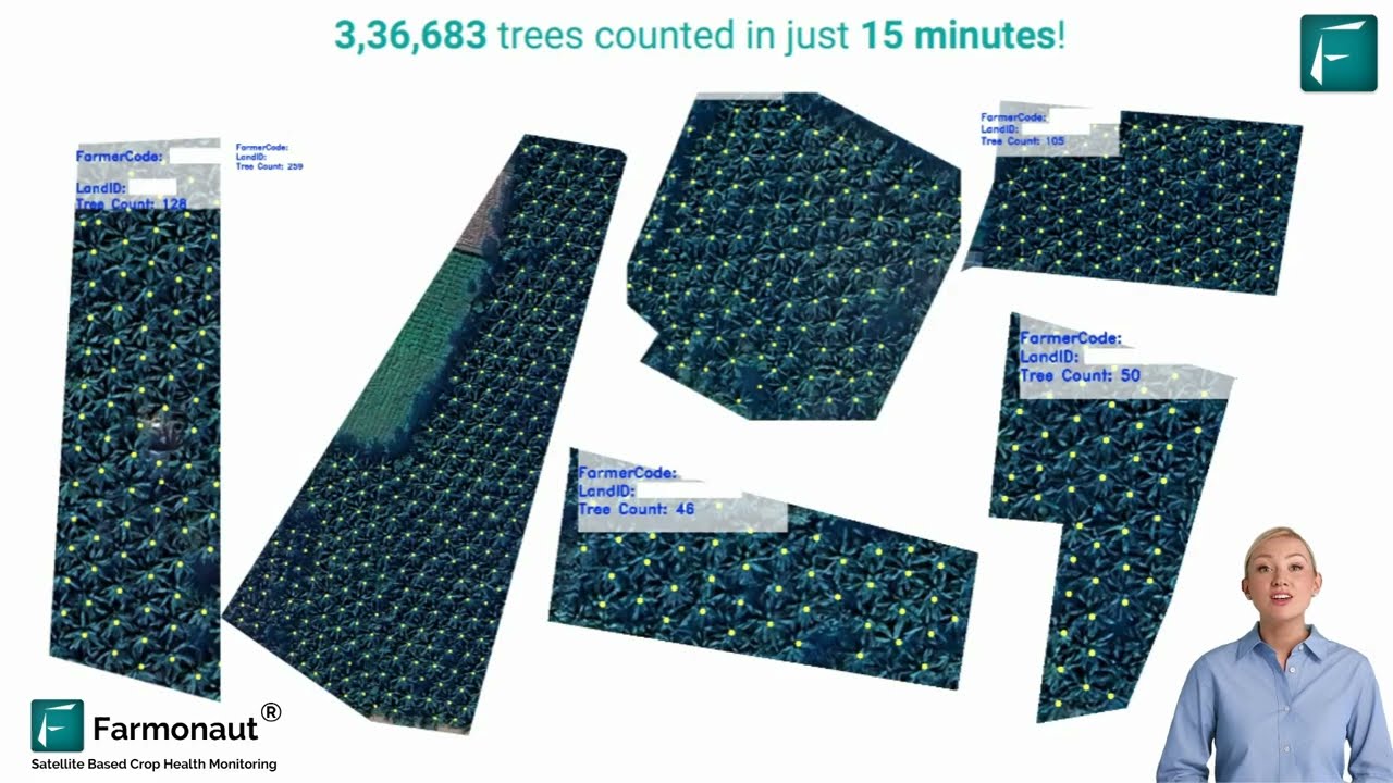
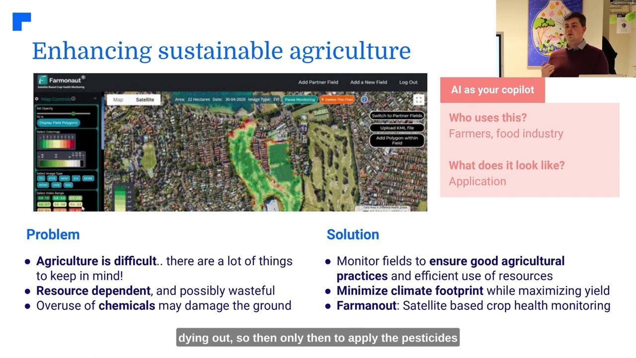
Farmonaut: Innovating Satellite-Based Farm & Forest Monitoring
As a pioneering agricultural technology company serving a worldwide audience, we at Farmonaut are committed to empowering farmers, agribusinesses, and governments with cost-effective, accessible remote sensing tools for EUDR reporting and beyond.
-
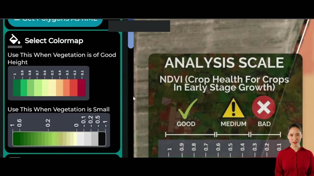
Satellite-Based Crop & Land Health Monitoring:
Our platform delivers analysis of multispectral satellite imagery for agriculture—unlocking real-time views of vegetation health (NDVI), soil moisture, and critical land use change detection across farms, plantations, and forests. -
AI-Powered Risk Analysis & Advisory:
The Jeevn AI Advisory System provides on-demand, personalized deforestation risk assessment, weather updates, and farming best practice recommendations—raising both productivity and compliance. -
Blockchain-Based Product Traceability:
With blockchain, every step from farm to consumer is logged and tamper-proof. This keeps traceability in supply chains robust, ensuring that EUDR compliance standards are always provable and trusted. -
Resource & Fleet Management:
Our fleet management services optimize the use and safety of agricultural machinery, furthering resource efficiency and sustainable farming. -
Carbon Footprinting:
Real-time carbon footprint analysis allows agribusinesses to track and reduce emissions, aligning production with global sustainability agreements.
By making advanced remote sensing and Earth Observation data affordable, our solutions help small farmers as well as large corporations achieve EUDR compliance without the need for expensive hardware or specialist expertise.
- Multi-access delivery: Use our web-app, Android & iOS apps, or API for seamless, device-agnostic integration in your daily workflow.
- Developer friendly: Integrate our satellite and weather APIs to power your own platforms. Learn more at Farmonaut API and check our API Developer Docs.
- Large-scale management: Need to analyze extensive holdings or manage collective areas? Explore the Large Scale Farm Management capabilities of our platform.
- Crop loan & insurance: We offer verification and monitoring tools for crop loans and agriculture insurance, supporting both rural banks and the farmers they serve.
In summary, we bridge the technology gap across the world’s farming and forestry communities—delivering intuitive remote sensing systems that grow with your needs and help ensure EUDR compliance from plot to port.
Blockchain-based traceability is essential in the EUDR era. Find out how our solution supports fully transparent product journeys at Farmonaut Product Traceability.
Challenges and Considerations for EUDR Remote Sensing & Monitoring
While remote sensing technologies offer transformative benefits for EUDR implementation, several challenges must be addressed to unlock their full potential—especially for inclusive global compliance:
-
Data Interpretation Accuracy:
Segregating forest from agricultural lands, particularly in areas with interspersed uses, agroforestry, or ambiguous tree cover, can be complex. Discrepancies exist between satellite records and national registries, as highlighted in Spain’s Extremadura region, where only a fraction of satellite-identified forest matched registry records. Standardization of definitions—and ground truthing—is critical. -
Technological Accessibility for Smallholders:
Smallholder farmers in developing countries often lack reliable internet, digital literacy, or resources to adopt remote sensing tools. Providing affordable, user-friendly apps and field support is key for sector-wide adoption. -
Integration of Multiple Data Sources:
For deforestation risk assessment to be robust, satellite imagery must be combined with supply chain records, ground observations, and jurisdictional data. This integration, while powerful, requires investments in secure cloud infrastructure and smart data fusion. -
Cost and Frequency Balance:
Although EO data is cost-effective at scale, regions with frequent cloud cover (e.g., equatorial forests) or high-resolution requirements (e.g., small plots or intensive cropping) may need supplementary drone or radar imaging, adding cost and complexity.
Addressing these obstacles ensures that remote sensing serves not just large enterprises, but also millions of farmers, local co-ops, and emerging markets in the race for sustainable agriculture practices and forest conservation.
Blockchain technologies offer tamper-proof records, and Farmonaut ensures end-to-end product traceability with its traceability solution.
The Future of EUDR Compliance & Remote Sensing Innovations
The landscape of deforestation monitoring is rapidly evolving—driven by continuous improvements in both hardware (satellite constellations, cloud-penetrating radar, high-res drones) and software (deep learning, data integration, and blockchain traceability).
Key trends to watch as the EUDR 2024 deadline approaches:
- Integration of AI & Big Data: Automated, real-time deforestation risk assessment—with anomaly alerts and predictive analytics—will empower proactive action and cost control.
- Interoperable Compliance Platforms: Open APIs (like Farmonaut’s Satellite & Weather API) will become industry standards, allowing seamless sharing and analysis of compliance data across organizations and regulatory authorities.
- Greater Accessibility: Mobile-first platforms and local languages will democratize advanced monitoring, giving even remote, rural farmers a level regulatory playing field.
- Better Land Classification Mapping: Next-gen satellite sensors and machine learning will improve separation of natural forests vs. farms, plantations, or silvopastoral systems—minimizing false positives and regulatory disputes.
As innovation accelerates—and with regulatory scrutiny rising—the worlds of agriculture, forestry, and tech must collaborate to close gaps and deliver sustainable, transparent, global supply chains.
Farmonaut will continue enhancing our remote monitoring and advisory capabilities for all users, supporting EUDR compliance and a greener future for both people and planet.
Get Started: Farmonaut’s Subscriptions and Access
Choose from flexible web, app, and API subscriptions to match your supply chain or compliance needs. We support individual farmers, agribusinesses, governments, and developers looking to unlock the full power of satellite-based EUDR monitoring.
Frequently Asked Questions (FAQ)
What is EUDR and how does it affect agriculture and forestry sectors?
The European Union Deforestation Regulation (EUDR) ensures that commodities sold within the EU are deforestation-free. This impacts the agriculture, forestry, and farming sectors by requiring that all products (coffee, cocoa, palm oil, soy, beef, and wood) are demonstrably sourced from land not deforested or degraded since December 2020.
How do remote sensing technologies help in EUDR compliance?
Remote sensing uses satellite imagery, drones, radar, and LiDAR to monitor land use changes, detect deforestation events, and verify the geolocation of sourcing. These objective, scalable tools replace traditional ground surveys, providing continuous compliance monitoring.
What kind of satellite imagery is best for deforestation monitoring?
Optical (e.g., Sentinel, Landsat), all-weather radar (e.g., Sentinel-1), and high-resolution commercial satellites offer robust solutions for monitoring deforestation and traceability in supply chains. Each has unique strengths for scale, frequency, and detail.
How does Farmonaut support EUDR compliance and traceability?
We provide farm and forest monitoring through EOS-based analytics, AI-powered risk assessment, product traceability via blockchain, and resource management tools. Our solutions support seamless record-keeping for compliance, integrating with apps and APIs.
How can smallholder farmers access these technologies?
Our mobile apps, web platform, and affordable subscriptions (see links above) make remote sensing accessible, helping small farms monitor compliance, improve yields, and participate in EUDR-regulated supply chains.
Is it possible to monitor carbon emissions with remote sensing?
Yes. Our carbon footprinting service tracks real-time field emissions, supporting sustainable agriculture and helping businesses comply with environmental requirements.
Where can I learn more or get started?
Try our web app, Android app, or iOS app free; learn more about developer access at our API portal. For enterprise or government solutions, visit Large Scale Farm Management.
Empower Your Deforestation-Free Journey with Remote Sensing
Prepare for a future where EUDR compliance is not an obstacle, but an opportunity to drive sustainability and transparency in your supply chains.
Leverage satellite imagery, AI, and remote sensing technologies for regulatory confidence and a healthier planet—explore Farmonaut’s solutions today.


