
GPS Guidance Systems Agriculture: Precision Farming 2025
“By 2025, over 80% of large farms worldwide are projected to use GPS guidance systems for precision agriculture.”
- Introduction: GPS Guidance Systems Agriculture in 2025
- How GPS Guidance Systems in Agriculture Work
- The Evolution of GPS Guidance Systems in Agriculture
- Advantages of GPS Agriculture Guidance Systems in 2025
- Precision Farming: Impact on Productivity, Costs, and Sustainability
- Variable Rate Applications and Resource Optimization
- GPS and Autonomous Farming Machinery Integration
- Environmental Benefits: Soil, Carbon Footprint, and Sustainability
- Data-driven Management: Analytics, Mapping, and Decision Support
- Farmonaut: Leading with Satellite-Driven Precision
- Comparative Features & Benefits Table: Precision Agriculture’s GPS Revolution
- Frequently Asked Questions (FAQ)
- Conclusion: Embracing GPS Agriculture Guidance Systems for the Future
Introduction: GPS Guidance Systems Agriculture in 2025
The integration of GPS guidance systems in agriculture over recent years has undeniably revolutionized traditional farming practices. As we step into 2025, GPS agriculture guidance systems have become indispensable tools for modern farmers worldwide. Their role in enabling smarter technologies, sustainable operations, and unprecedented accuracy is transforming not just individual farms but the entire agricultural sector.
In this comprehensive guide, we explore how GPS guidance systems agriculture enhances precision, productivity, and environmental sustainability in 2025. We also unveil the innovative leap toward autonomous machinery, and how data-driven decision-making is shaping the new era of smart and efficient farming.
Whether you are a large-scale commercial farm owner, a technology enthusiast, or a policymaker, understanding the state-of-the-art in GPS agriculture guidance systems is critical for thriving in the evolving landscape of precision agriculture.
How GPS Guidance Systems in Agriculture Work
GPS guidance systems agriculture refer to farming technology that utilizes satellite-based positioning and navigation to direct agricultural machinery with remarkable precision. At the core, these systems:
- Utilize signals from multiple satellites (Global Positioning System and similar constellations like GLONASS, Galileo) to determine the exact location of farm equipment.
- Guide machinery (such as tractors, planters, sprayers, and harvesters) during tasks such as planting, fertilizing, spraying, and harvesting.
- Enable real-time navigation, automated steering, and precise path-following, minimizing overlaps and gaps in field operations.
Unlike traditional manual control or mechanical guidance, GPS-based approaches improve accuracy, reduce input waste, and enable automation. This ensures that every activity is performed on the right area of the field, supporting precision and efficiency.
Key features of modern GPS guidance agriculture systems include:
- Automated steering for fatigue-free, straight, and repeatable passes
- Integration with farm management software for seamless data logging
- Compatibility with variable rate technologies for tailored crop treatments
- Real-time feedback and error alerts to the operator or autonomous system
2025 marks a peak in accessibility, reliability, and accuracy for GPS-driven agriculture guidance.

The Evolution of GPS Guidance Systems in Agriculture
The journey from basic navigation aids to today’s automated, data-driven GPS guidance systems agriculture highlights continuous innovation:
- Initial Years: Early adopters relied on basic satellite signals (accuracy 20-50 meters) to reduce overlaps in field passes.
- 2000s-2010s: Differential GPS (DGPS) improved accuracy to 1-3 meters, reducing missed & overlapping areas.
- 2015-2020: The introduction of Real-Time Kinematic (RTK) GPS brought centimeter-level precision, enabling advanced practices like variable rate application and autonomous navigation.
- 2025: Seamless integration with AI, automation, satellite analytics, and farm management systems makes precision the cornerstone of sustainable agriculture.
This evolution has transformed the economics, efficiency, and sustainability of agriculture, positively impacting yield and resource management.

Advantages of GPS Agriculture Guidance Systems in 2025
What makes GPS guidance systems agriculture so pivotal for 2025 and beyond? The advantages are both practical and strategic—empowering sustainable, high-yield, and cost-effective farming.
- Unparalleled Precision: Modern systems achieve centimeter-level accuracy (with DGPS or RTK), eliminating guesswork in field operations.
- Cost Efficiency: Minimizing overlaps and missed areas means reduced use of seeds, fertilizers, and pesticides—significantly lowering input costs.
- Improved Yield and Productivity: Ensuring consistent, optimized coverage of fields directly enhances crop output.
- Environmental Impact Reduction: Precision reduces chemical runoff, soil compaction, and the farm’s carbon footprint.
- Time and Labor Savings: Automation reduces operator fatigue, expedites field work, and frees up workers for higher-value tasks.
- Foundation for Autonomous Equipment: Modern autonomous tractors and harvesters rely on GPS guidance agriculture for safe, reliable, and efficient operations.
One of the primary advantages of GPS guidance systems is their critical role in enabling data-driven farm management, supporting new sustainability mandates, and making advanced precision farming accessible to all scales of operation.
“Autonomous tractors with GPS guidance can reduce field overlap by up to 90%, significantly improving resource efficiency in farming.”
Looking to optimize your field operations, fuel usage, and machinery health with smart navigation and real-time tracking?
Our satellite-driven Fleet Management solution enables you to track, monitor, and manage all your agricultural equipment efficiently for maximum productivity and minimum costs.


Precision Farming: Impact on Productivity, Costs, and Sustainability
At the heart of precision agriculture in 2025 lies the effective use of GPS guidance systems to address three pillars:
- Productivity: Predictable, reliable machinery paths ensure every square meter of field is utilized for optimal plant growth and crop yield.
- Cost Reduction: Precise input applications reduce wastage, saving on fuel, labor, and other expenses—including environmental costs associated with over-application of agrochemicals.
- Sustainability: Efficient use of resources, less chemical runoff, and minimized soil disturbance all contribute to healthier soils, cleaner water, and more resilient ecosystems.
Examples of improved field operations include:
- Planting: GPS-controlled planters plant seeds at precise intervals and depths, maximizing use of field space.
- Fertilizing: Variable rate technology informed by GPS ensures fertilizers are only dropped where needed, reducing costs and preventing over-fertilization.
- Spraying: Automated sprayers cover every plant systematically, minimizing wasted chemicals and protecting neighboring biodiversity.
- Harvesting: GPS-guided harvesters follow optimized routes, reducing losses due to missed rows or repeated passes.
- Minimizing overlaps in each field pass has a cascading positive effect on both profitability and the planet.
Environmental impact tracking is crucial for modern, sustainable agriculture. Our Carbon Footprinting solution provides actionable insights into your farm’s emissions, resource use, and sustainability, supporting data-driven eco-friendly management decisions.
Variable Rate Application and Resource Optimization Through GPS Guidance Systems Agriculture
One of the most transformative capabilities of GPS agriculture guidance systems in 2025 is the precise variable rate application of inputs—applying the right amount of fertilizer, pesticide, or water, at exactly the right location and time.
How does this work?
- Satellite and in-field sensors detect soil variability, crop health, and environmental conditions across different field areas.
- GPS-guided equipment receives this data, allowing applications to be applied variably across the field, instead of uniformly.
- Outcomes: Optimized use of costly inputs, enhanced yields, minimized waste, and improved environmental outcomes by reducing excess chemical application.
For instance, a farm using RTK-GPS guided tractors can apply nitrogen fertilizer at three different rates across a field, as soil test data and satellite analytics indicate variable nitrogen potential. This targeted management would be impossible without precise GPS navigation and data integration.

Want to maximize forest plantation yields or advise on best crop practices using satellite analysis? Explore our science-backed Crop Plantation & Forest Advisory tools for sustainable village, state, or enterprise projects.
GPS Guidance Agriculture and Autonomous Farming Machinery
In 2025, autonomous farm equipment has moved into mainstream deployment, especially on large-scale and technologically forward-thinking farms.
- GPS guidance systems agriculture sit at the heart of autonomous tractors, planters, and harvesters.
- These machines rely on advanced GPS positioning for safe, accurate navigation—steering along path maps and adjusting routes in real-time.
- Operator errors and fatigue are virtually eliminated, while machine learning adapts paths to field conditions in real time.
Benefits of GPS-driven autonomy in the farm sector:
- Labor Efficiency: Large fields can be managed with limited staff, enabling scalable operations even during labor shortages.
- Time Savings: Autonomous machines can work around the clock, maximizing use of planting and harvesting windows.
- Resource Reduction: GPS navigation minimizes overlaps, reducing seed, fertilizer, pesticide, and fuel usage per hectare.
Example: A 2025 model combine harvester equipped with RTK GPS can harvest a complex-shaped field with less than 2% missed area, compared to over 15% with human guidance alone.
Environmental Benefits: Soil Health, Carbon Footprint, and Sustainable Agriculture
Adopting GPS guidance systems agriculture yields measurable environmental benefits, especially important as regulators, consumers, and producers all focus on sustainability:
- Reduced Chemical Runoff: Over-application of pesticides and fertilizers is avoided, limiting contamination of local water bodies.
- Minimized Soil Compaction: By guiding heavy equipment along the most efficient paths, soil structure is preserved, supporting root health and water retention.
- Lower Carbon Emissions: Route optimizations reduce excess fuel use, directly shrinking the carbon footprint of field operations.
- Enhanced Biodiversity: Targeted input application minimizes off-target impacts, protecting beneficial insects and non-crop vegetation.
In short, modern GPS guidance agriculture systems are critical tools for helping farms meet global sustainability targets.
Building trust and transparency is easier than ever. Discover our Blockchain-based Product Traceability Solution, which enables end-to-end tracking of farm produce, bolsters food safety, and enhances marketability worldwide.
Data-Driven Management: Analytics, Mapping, and Decision Support with GPS Agriculture Guidance
The next frontier in farming productivity is not just collecting data—but turning it into actionable insights. GPS agriculture guidance systems are fully integrated with digital platforms for continuous, real-time farm management:
- Field Mapping: Accurately maps yield variability, soil conditions, and crop health for targeted management.
- Operation Analysis: Tracks efficiency, operator errors, and resource utilization at individual equipment, operator, and field levels.
- Yield Prediction and Traceability: Combines spatial data with satellite imagery for adaptive decisions, insurance verification, and supply chain confidence.

Looking for a robust, satellite-verified approach to agricultural loans and insurance? Our Crop Loan & Insurance Verification streamlines processes, reduces fraud, and empowers growers with fair financial access.
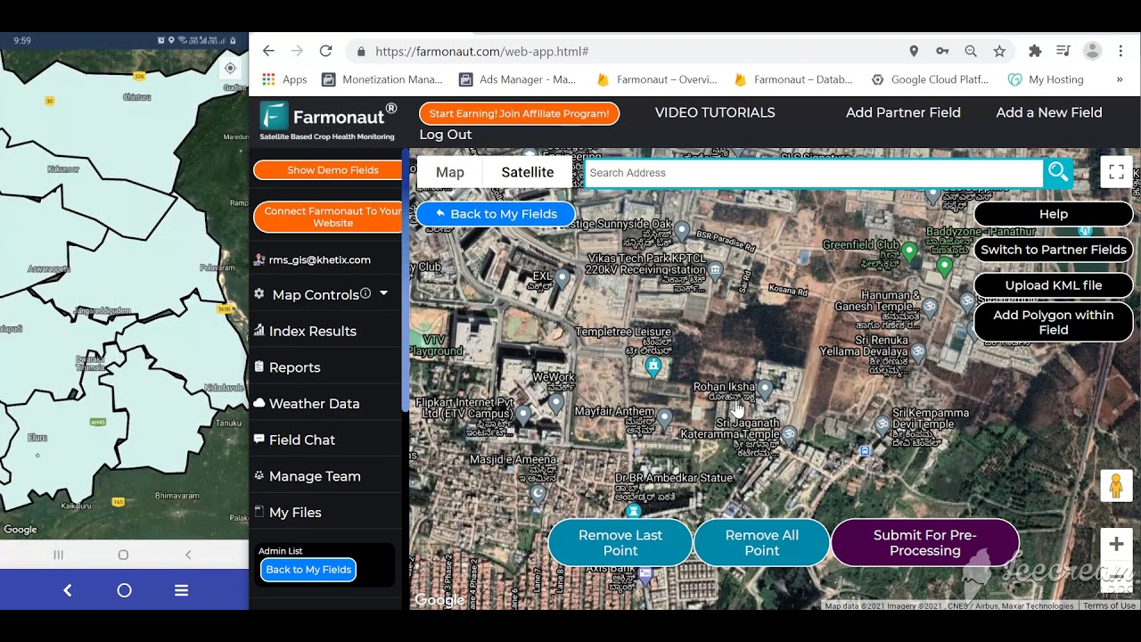
Farmonaut: Leading with Satellite-Driven Precision in GPS Guidance Systems Agriculture
At Farmonaut, we help drive the precision farming revolution in 2025 and beyond by making affordable, scalable, and actionable satellite data available to every agricultural stakeholder:
- Satellite-Based Monitoring: We offer multispectral satellite imagery to monitor crop health (NDVI), soil conditions, moisture status, and infrastructure, supporting real-time field oversight and decision-making.
- JEEVN AI Advisory System: Our AI engine transforms GPS and satellite data into tailored recommendations, weather forecasts, operation schedules, and more.
- Resource, Fleet, & Environmental Management: Optimize vehicle and input usage in real-time, ensuring maximum productivity at lower costs while tracking carbon and ecological impact.
- Blockchain Traceability: We provide supply chain transparency, connecting GPS field operations to final product assurance worldwide.
- API Access & App Integration: Our data powers custom solutions through web platform, mobile apps, or API (see our API portal and API developer docs).
By bringing together best-in-class GPS guidance agriculture, AI analytics, fleet logistics, and environmental tracking, we empower every farm—large or small—to maximize yield, efficiency, and sustainability in 2025 and beyond.
Explore Large-Scale Farm Management Solutions & Admin App for enterprises overseeing thousands of acres or multi-region portfolios, integrating GPS, satellite, and AI-driven advisories for end-to-end management and reporting.
Comparative Features & Benefits Table: Precision Agriculture’s GPS Revolution
| Year/Generation | Key GPS Features | Estimated Yield Improvement (%) | Resource Savings (Fuel/Seed) (%) | Sustainability Impact | Autonomous Machinery Integration |
|---|---|---|---|---|---|
| 1990s Early Adoption |
Basic GPS, 20–50m accuracy, manual guidance | 2–5% | 5–10% | Minimal, reduced overlaps | None |
| 2000s Differential GPS (DGPS) |
1–3m accuracy, auto-steering aids, DGPS | 7–12% | 12–15% | Reduced input use, less chemical runoff, better field coverage | Limited (operator assistance) |
| 2010s RTK GPS & Mapping |
RTK (<1–2cm), field mapping, variable rate application | 15–22% | 18–25% | Marked fuel, chemical reductions, improved soil health | Partial (some autonomous equipment) |
| 2025 Advanced Intelligent Systems |
AI-enhanced GPS, satellite & sensor interfaces, full automation | 25–32% | 28–45% |
Significant (carbon tracking, minimized compaction, variable input, ecosystem health) |
Mainstream adoption (autonomous tractors, drones, intelligent fleets) |
The above feature table highlights the quantum leap in GPS guidance agriculture, from basic navigation to today’s fully automated, sustainable, and data-driven operations.
(Values are estimates and may vary by crop, region, and operational practices. All data is based on aggregate industry analysis for 2025.)
Frequently Asked Questions (FAQ) — GPS Guidance Systems in Agriculture (2025)
-
What is a GPS guidance system in agriculture?
A GPS guidance system in agriculture is a technology setup that uses signals from multiple satellites to pinpoint the exact position of farm machinery in the field. It guides operations like planting, spraying, and harvesting, ensuring precise, repeatable, and efficient fieldwork.
-
How precise are GPS guidance systems agriculture in 2025?
Modern systems—especially those using differential corrections (DGPS) or RTK (Real-Time Kinematic GPS)—offer centimeter-level accuracy. This allows for extremely tight control of machinery and input application.
-
How do GPS guidance systems help reduce farming costs?
By minimizing overlaps, missed areas, and unnecessary use of seeds, fertilizer, and fuel, GPS systems significantly lower operational costs.
-
Are GPS guidance systems only for large farms?
No! While adoption began in large commercial operations, cost reductions and user-friendly interfaces mean small and medium farms can now benefit from GPS agriculture guidance systems.
-
Can GPS guidance agriculture support sustainable practices?
Absolutely. Precision farming enabled by GPS means less waste, reduced chemicals in the environment, and better soil and water management.
-
What’s the connection between GPS guidance and autonomous farming machinery?
Autonomous tractors, drones, and harvesters rely on GPS guidance for path following, navigation, and real-time route adjustments, laying the foundation for fully automated agriculture.
-
How is satellite data integrated with GPS guidance systems?
Satellite imagery can provide crucial information about crop health, soil variability, and environmental stress. When combined with GPS, this data allows for variable rate applications, better planning, and actionable decision support.
-
Do GPS systems in agriculture require internet connectivity?
Basic GPS guidance does not require continuous internet. However, updating maps, integrating with satellite imagery, and syncing with farm management systems are typically done online to leverage the full suite of data-driven tools.
Conclusion: Embracing GPS Agriculture Guidance Systems for the Future
GPS guidance systems agriculture now form the backbone of modern, precision-driven, and sustainable farming practices. By enabling exact machine navigation, reducing costs, optimizing inputs, and supporting autonomous machinery, they directly advance global food security, business profitability, and environmental protection.
As satellite technology, AI, and agricultural best practices continue to advance beyond 2025, integrating GPS agriculture guidance systems into every facet of farm operations is no longer optional—it is the benchmark for competitive, resilient, and sustainable agriculture worldwide.
At Farmonaut, we are committed to making this technology accessible to every farmer, advisor, and agri-business. Unlock the power of GPS guidance systems, satellite analytics, and autonomous innovations to confidently lead your farm or enterprise into the future of agriculture!


