

Gold mine guide · Dominican Republic
Pueblo Viejo Mine, Dominican Republic: Facts and Output
Pueblo Viejo is a Barrick-operated open-pit gold mine (Barrick 60%, Newmont 40%) with 20 million ounces of reserves and about 630,000 ounces recovered in 2025. This guide covers output, costs, taxes, tailings and resettlement.
Key takeaways
- Barrick operates Pueblo Viejo and owns 60%; Newmont owns 40% (Barrick technical report, February 2026).
- Reserves at the end of 2025 were 20 Moz of gold in 310 Mt at 2.06 g/t; measured and indicated resources were 25 Moz (100% basis).
- The mine recovered about 630,000 oz of gold in 2025, down from a 2016 peak of about 1.17 Moz; the average feed grade fell from 6.14 g/t in 2013 to 2.38 g/t in 2025.
- Barrick’s all-in sustaining cost at its 60% share was US$1,412 per oz in 2025 (Barrick Annual Report 2025).
- The Naranjo tailings facility needs about 3,500 ha and six resettled communities; Barrick reported 570 families resettled by August 2026.
In this article
- Pueblo Viejo mine at a glance
- Who owns and runs the Pueblo Viejo mine
- Where the mine is and what kind of gold deposit it is
- From Rosario to Barrick: a short history
- How much gold the mine produces
- How much gold is left: reserves and resources
- How the ore is processed
- What an ounce costs to produce
- Estimate recovered gold from your own numbers
- Taxes, royalty and the streaming deal
- Tailings, water and the Naranjo expansion
- Resettlement and the communities around the mine
- What satellite data can show at a mine like this
- What to check when you read a mine report
Pueblo Viejo is an open-pit gold and silver mine in the Dominican Republic, about 12 km south-southwest of the town of Cotuí and 55 km north-northwest of Santo Domingo. Barrick operates it and owns 60%; Newmont owns the other 40%. At the end of 2025 its proven and probable reserves were 20 million ounces of gold, and it recovered about 630,000 ounces during 2025 (all figures on a 100% basis, from Barrick’s Pueblo Viejo technical report dated 27 February 2026).
This guide gives the facts people search for: who owns the mine, how much gold it makes, how much is left, what it costs to produce an ounce, what the government earns, and how the tailings dam and resettlement programme work. It also answers the common question “is there gold in the Dominican Republic”. Every figure carries its source and date, and terms are explained the first time they appear.
Pueblo Viejo mine at a glance
The table collects the main facts. “Moz” means million ounces, and “g/t” means grams of gold per tonne of rock, the usual measure of grade.
| Item | Fact | Source and date |
|---|---|---|
| Location | Sánchez Ramírez province, central Dominican Republic, on the island of Hispaniola | Barrick technical report, 27 Feb 2026 |
| Operator and owners | Barrick 60% (operator), Newmont 40% | Barrick technical report; Newmont Form 10-K, FY2025 |
| Mine type | Open pit, truck and shovel; Moore and Monte Negro pits plus the small Cumba satellite pit | Barrick technical report |
| Deposit type | High-sulfidation epithermal gold, silver, copper and zinc | Newmont Form 10-K, FY2025 |
| First gold | 2012; ramp-up to initial design capacity completed in 2014 | Barrick technical report |
| Gold recovered in 2025 | About 630,000 oz (100% basis); 379,000 oz on Barrick’s 60% share | Barrick technical report; Barrick Annual Report 2025 |
| Gold reserves, end of 2025 | 20 Moz in 310 Mt at 2.06 g/t (100% basis) | Barrick technical report |
| Workforce | About 3,000 direct employees and 3,800 contractors | Barrick technical report |
| Planned pit life | Until 2048, with low-grade stockpiles processed to 2049 | Barrick technical report |
Modern mining began in 2010 (pre-stripping started in August 2010) and the first gold came in 2012. An older operation on the same deposit worked from 1975, as the history section below shows.
Who owns and runs the Pueblo Viejo mine
The mineral rights sit in one company, Pueblo Viejo Dominicana Corporation (PVD), which is owned 60% by Barrick and 40% by Newmont. Barrick runs the mine and reports PVD as a subsidiary, so its tables show results on a 60% basis with a 40% non-controlling interest (Barrick Annual Report 2025). Newmont treats its 40% as an equity-method investment, meaning it reports its share of profit rather than adding the mine line by line to its accounts (Newmont Form 10-K for 2025). Newmont’s attributable share of 2025 gold output was 253,000 ounces (Newmont Q4 2025 operating statistics), which is 40% of the 630,000 ounces above.
The operator’s ownership structure may change. In its second-quarter 2026 results of 10 August 2026, Barrick said it is advancing an initial public offering of a minority stake in a new company that would hold its interests in Nevada Gold Mines and Pueblo Viejo, the Fourmile project and other North American assets, that it expects to complete the offering by the end of 2026 subject to market conditions and approvals, and that Newmont has consented (Barrick Q2 2026 results). This is the company’s plan, not a completed transaction.
Where the mine is and what kind of gold deposit it is
The mine sits on the Montenegro Fiscal Reserve, an area set aside by presidential decree for mineral leasing that covers about 7,995 hectares (19,756 acres), according to the Newmont Form 10-K. The ore comes from two main areas, the Monte Negro and Moore pits.
Geologically, Pueblo Viejo is a high-sulfidation epithermal deposit. “Epithermal” means the gold was deposited from hot, acidic water close to the surface, in volcanic rocks. “High-sulfidation” means the fluids carried a lot of sulfur, which left the gold locked inside sulfide minerals such as pyrite. That makes the ore “refractory”: a plain cyanide leach cannot get the gold out until the sulfides are broken down first. This one fact explains much of the mine’s cost and its tailings design, covered below. For the wider picture of how deposits like this are found, see our guide to gold deposit types, signs and methods.
From Rosario to Barrick: a short history
The technical report gives the timeline in detail. The main steps are:
- 1969 to 1975: Rosario Resources of New York optioned the property, and open-pit mining of the near-surface oxide ore began in 1975.
- 1979 to 1999: the Dominican Central Bank bought the foreign-held shares in 1979. Over 24 years of historical production the old mine produced about 5.5 Moz of gold and 25.2 Moz of silver, then the oxide ore it could process ran out.
- 2001: after an international bid, Placer Dome won the lease and later agreed a Special Lease Agreement (SLA) with the government.
- 2006: Barrick bought Placer Dome and sold 40% of Pueblo Viejo to Goldcorp, which Newmont acquired in 2019.
- 2009 and 2013: the SLA was amended twice. The second amendment, effective 5 October 2013, brought additional and faster tax payments to the government.
- 2010 to 2012: modern mining began in 2010 and the first gold was poured in 2012.
The old operation did not close its pits and dumps properly. The report calls that a legacy of polluted soil and water, and we return to it in the environment section. Source for the whole list: the February 2026 technical report.
How much gold the mine produces
Annual gold output peaked in 2016 at about 1.17 Moz and was about 630,000 ounces in 2025 (100% basis). The fall is mostly a grade story. The average grade of ore fed to the plant dropped from 6.14 g/t in 2013 to 2.38 g/t in 2025, and the share of gold recovered fell from 93.0% to 75.1% over the same span, while the plant processed more rock each year (10.9 million tonnes in 2025 against 4.4 million in 2013). The pit stages were designed to take higher-grade ore early, so a falling grade is built into the plan. The technical report also notes that recovery depends strongly on the sulfur content of the feed.
Chart
Gold recovered at Pueblo Viejo, 2012 to 2025
Thousand ounces per year, 100% basis
Barrick’s own results show the recent direction. On its 60% share, gold produced was 335,000 ounces in 2023, 352,000 in 2024 and 379,000 in 2025 (Barrick Annual Report 2025). In the second quarter of 2026 Barrick credited a faster-than-expected recovery at Pueblo Viejo after planned maintenance in the first quarter for part of its company-wide result (Barrick Q2 2026 results).
For scale, 630,000 ounces is about 19.6 tonnes of gold. The US Geological Survey estimates world mine production at 3,300 tonnes for 2025, so this one mine is roughly 0.6% of the world total (USGS Mineral Commodity Summaries 2026, gold; the ratio is our calculation).
For a closer look at a related question, see our guide: Baffin Island Iron Mine: Output, Debt and Steensby Rail.
If this topic matters to you, read Paracatu Minas Gerais: Gold Mine Output and Facts next.
How much gold is left: reserves and resources
Two terms matter here. A “mineral resource” is rock that could one day be mined, estimated at a long-term price. A “mineral reserve” is the part that a study shows can be mined at a profit with current methods, so it is the smaller, firmer number. At the end of 2025 the technical report gives:
Chart
Gold at Pueblo Viejo: past output, reserves and resources
Million ounces of gold, 100% basis; the four bars are different measures
- Reserves: 310 Mt at 2.06 g/t gold, holding 20 Moz of gold and 120 Moz of silver (100% basis), estimated at a gold price of US$1,500 per ounce. About 14 Moz sit in open pits and about 6 Moz in stockpiles of lower-grade ore.
- Measured and indicated resources: 410 Mt at 1.89 g/t, or 25 Moz of gold, at US$2,000 per ounce. These include the reserves.
- Inferred resources: 16 Mt at 1.5 g/t, about 0.77 Moz, the least certain category.
Reserves fell by only 38,000 ounces during the year even though mining and stockpile use removed 1,109,000 ounces, because updates to costs, pit designs, block models and price added about 1,147,000 ounces, partly offset by lower metallurgical recovery factors (Barrick technical report). Barrick reports its attributable ounces at 60%; Newmont reported 8.2 Moz of attributable gold reserves for its 40% share at the end of 2025 (Newmont Form 10-K).
How the ore is processed
The plant is designed for about 14 million tonnes of ore a year after a plant expansion that added a crusher, a SAG mill (a large mill that grinds rock using the rock itself and steel balls), a flotation circuit and extra leaching capacity. The main steps are:
Infographic
From pit to doré in 5 steps
- 1MineTrucks and shovels move ore from the Moore and Monte Negro pits.
- 2GrindCrushers and mills make a slurry; lower-grade ore is floated first.
- 3OxidiseFour autoclaves break down the sulfide minerals.
- 4LeachCyanide dissolves the gold and silver, recovered as doré.
- 5StoreNeutralised tailings go to the tailings storage facility.
- Trucks and shovels move ore from the Moore and Monte Negro pits to crushers.
- Grinding mills reduce the ore to a slurry. Lower-grade ore passes through flotation first, which concentrates the sulfide minerals.
- Four autoclaves, pressurised steel vessels, use oxygen and heat to break down the sulfides in a step called pressure oxidation.
- A cyanide leach circuit then dissolves the freed gold and silver, which are recovered as doré (a rough gold-silver alloy sent to a refinery).
- Tailings, the waste slurry left over, are neutralised and stored in a tailings storage facility (TSF).
The process needs large amounts of limestone and lime, so quarries next to the mine have supplied material since 2009 (Barrick technical report). That is why the life-of-mine plan, at around 81 million tonnes a year on average, counts limestone as well as ore and waste.
What an ounce costs to produce
Two cost measures are standard in gold. “Total cash costs” cover mining, processing, site overhead and royalties. “All-in sustaining costs” (AISC) add the capital needed to keep the mine running, plus overhead and exploration tied to the operation, so AISC is the fairer comparison between mines. On Barrick’s 60% basis, Pueblo Viejo’s AISC was US$1,249 per ounce in 2023, US$1,323 in 2024 and US$1,412 in 2025. Total cash costs were US$889, US$1,005 and US$1,034 per ounce (Barrick Annual Report 2025). For 2026, Barrick’s February 2026 guidance, reaffirmed on 10 August 2026, is AISC of US$1,590 to US$1,760 per ounce for the mine on production of 350,000 to 400,000 ounces on its share, using a guidance gold price of US$4,500 per ounce.
Chart
All-in sustaining cost at Pueblo Viejo
US$ per ounce of gold sold, Barrick’s 60% share
The technical report estimates the average operating cost over the life of the mine at US$50.12 per tonne of ore processed and life-of-mine capital at US$4,177.8 million, which includes finishing the plant expansion and building the Naranjo tailings facility. The expansion project itself carries a capital estimate of about US$2.6 billion on a 100% basis, of which US$1,229 million had been spent by the end of 2025 (Barrick Annual Report 2025).
Estimate recovered gold from your own numbers
The calculator below turns tonnes, grade and recovery into recovered ounces and a gross value. The defaults are round example numbers based on the mine’s 2025 plant averages (10.9 Mt fed, 2.38 g/t, 75.1% recovery); the feed is rounded down to 10 Mt, so the result sits below the mine’s actual 2025 output. They are not a forecast. It is a back-of-envelope tool: it ignores operating costs, payment terms and the streaming deal described next.
Calculator
How much gold does a plant recover, and what is it worth?
Enter your own plant feed, grade, recovery and price.
- Gold in the ore before recovery (oz): 771,617
- Gross value of recovered gold (US$): $1,157,426,013
- Royalty at the rate above (US$, upper bound): $37,037,632
Example values only, not a forecast. Defaults are rounded from the 2025 plant averages in the Barrick technical report (10.9 Mt fed, 2.38 g/t, 75.1% recovery). Prices are inputs: example, use today’s price. The royalty line applies the 3.2% net smelter royalty rate from the Special Lease Agreement to gross value as an upper bound, because the real royalty is charged after some deductible costs. Costs, taxes and streaming are not included, so this is gross value, not profit.
Taxes, royalty and the streaming deal
Under the Special Lease Agreement, the operating company pays the Dominican government a net smelter royalty (NSR) of 3.2% on gross revenue less some deductible costs, a net profits interest (NPI) of 28.75% of adjusted taxable cash flow, and corporate income tax under a stabilised regime. There is also an annual minimum tax of 25% that applies when a formula based on the gold price and gross receipts exceeds the NPI plus income tax. The minimum-tax model is reset every three years; the 2023 to 2025 model was in force and a 2026 to 2028 model was awaiting ministry review at the date of the report (Barrick technical report).
The company says it paid more than US$649 million in taxes in 2025, US$431 million more than in 2024, and US$440 million so far in 2026, with more than US$2.6 billion paid since 2013, according to a report of 17 September 2026 quoting the president of Barrick Pueblo Viejo (elDinero, 17 September 2026). The Dominican director general of mining said mining exports were about US$2.5 billion in 2025, inside national exports above US$14.6 billion, and that gold exports should keep rising with the Pueblo Viejo expansion (Acento, 16 February 2026). Both are statements by the company and the ministry, not audited tax data.
A separate arrangement affects Barrick’s revenue. In 2015 Barrick sold Royal Gold a stream on its 60% share: 7.5% of gold produced until 990,000 ounces are delivered (3.75% after that) and 75% of silver until 50 Moz are delivered (37.5% after that). Royal Gold pays 30% of the spot price for the first 550,000 ounces of gold and 23.1 Moz of silver, then 60%. By 31 December 2025 about 397,000 ounces of gold and 14 Moz of silver had been delivered (Barrick technical report). On streamed ounces, Barrick therefore receives less than the market price.
Tailings, water and the Naranjo expansion
The environmental story has two parts: what the old operation left behind, and what the current one must manage.
The old operation left acid rock drainage (ARD). When sulfide minerals in pit walls, waste rock and stockpiles meet air, water and bacteria, they form acid that dissolves metals and runs into streams. The technical report says the Rosario-era mine was not closed or reclaimed properly, and the result was polluted soil and water, rusting machinery, mercury-contaminated material, asbestos and tailings that escaped into nearby watersheds. Under the lease, the operating company is responsible for clean-up inside the mine area, while the government handles older impacts outside it. In 2009 the company agreed to donate up to US$37.5 million toward the government’s clean-up, half of its US$75 million estimate, and in December 2010 it agreed to contribute the remaining US$37.5 million on the government’s behalf, to be repaid from mine revenues. Mitigation work on the old tailings ponds (seismic measures and a cover) is in progress, with final design planned for 2026 (Barrick technical report).
The current mine neutralises tailings before storage and treats water at an effluent treatment plant. The plan requires discharge to meet the Dominican standards for mining effluents and receiving water quality, and potentially acid-generating waste rock goes to dedicated dumps, with disposal moving into the new Naranjo facility from 2028 (Barrick technical report). Barrick’s 2025 report says engineering for a new effluent treatment plant was 85% complete and the construction contract had been awarded.
The Naranjo TSF is the key project for the mine’s future, because the life-of-mine plan to 2049 depends on it. It needs about 3,500 hectares, plus 1,056 hectares south of it for perimeter roads and an environmental buffer zone. A change to the environmental permit and a permit for temporary water structures and a starter dam were expected in the first half of 2026 (technical report). In its second-quarter 2026 results, Barrick said the permits for the temporary water management structures were secured and that approval of the starter dam permit is targeted for the first quarter of 2027.
The technical report does not publish stream chemistry or soil data for the surrounding district. For independent context, read the company’s annual sustainability disclosures and the permit files of the Dominican environment ministry. Our explainer on the environmental effects of open-pit mining covers the general mechanisms.

▶ A plain-language claymation on the seven environmental impacts of mining. · 2:31
Resettlement and the communities around the mine
The Naranjo facility needs six communities to move. The resettlement plan was completed in June 2025, and the preliminary studies identified about 680 households as affected. The plan follows national law and is guided by Performance Standard 5 of the International Finance Corporation, which says involuntary resettlement should be avoided where possible and, where it cannot, compensation and living conditions should be improved and communities consulted throughout (IFC Performance Standard 5).
Progress as reported by Barrick in August 2026: package acceptance reached 95%, more than 632 homes were complete and 570 families were resettled, while design continued for a church, a polytechnic school and 63 government houses (Barrick Q2 2026 results). The earlier resettlement for the El Llagal tailings facility moved three communities, 369 households and 1,338 people, and was completed in 2009 into a new community called El Nuevo Llagal in the municipality of Maimón (technical report).
These figures describe the company’s programme. Whether families are satisfied with the terms is a separate question; the company runs a grievance mechanism for complaints, and readers who need that view should read community and non-governmental reports alongside the company’s.
What satellite data can show at a mine like this
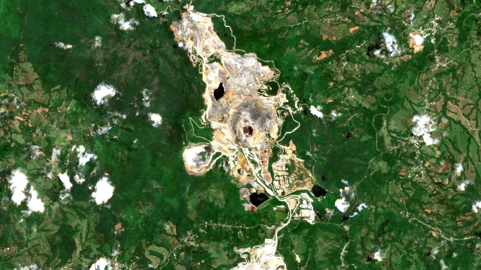
Sentinel-2 satellite images, at 10 metre detail, can show the footprint of pits, dumps and tailings dams, vegetation change around them, and the progress of new construction such as the Naranjo area. They cannot measure gold grade underground or water chemistry; companies still need drilling and sampling for that. The image at the top of this page is a Sentinel-2 composite of the district.
Farmonaut is a US-based company that builds satellite mineral-exploration reports for licence areas. If you hold ground in a similar epithermal setting and want a target screen before drilling, you can read how satellite mineral detection works, request a quote or contact the team. For another Dominican example, see copper zones in the Dominican Republic. Satellite results are exploration targets, not resource estimates.
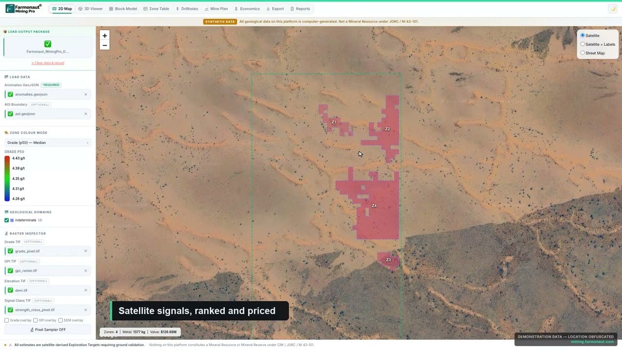
▶ A quick look at the Farmonaut Mining Pro platform, which turns a licence boundary into a geological and economic picture. · 4:56
What to check when you read a mine report
- Basis: is the number for 100% of the mine or for one owner’s share? Barrick shows 60%, Newmont 40%.
- Date and price: reserves and resources are reported at a stated date and gold price. Pueblo Viejo’s reserves use US$1,500 per ounce and its resources US$2,000.
- Reserve or resource: only reserves have been shown to be mineable at a profit.
- Feed grade, not pit grade: recovery losses and stockpiles change what reaches the plant.
- Who said it: a technical report signed by a named qualified person and a stock-exchange filing carry legal weight; a press article quoting an executive does not.
The same checks help when you assess a gold mine offered for sale; our gold mine due diligence checklist goes further on title, geology and risk.
Frequently asked questions
Where is the Pueblo Viejo mine?
It is in Sánchez Ramírez province in the central Dominican Republic, about 12 km south-southwest of Cotuí and 55 km north-northwest of Santo Domingo (Barrick technical report, February 2026).
Who owns the Pueblo Viejo gold mine?
Barrick owns 60% and operates it. Newmont owns 40%. Barrick has said it plans a minority stock-market listing of a new company that would hold its Pueblo Viejo and Nevada Gold Mines interests, targeted for the end of 2026.
Is Pueblo Viejo one of the largest gold mines in the world?
It has a large reserve base, with 20 Moz of gold in reserves at the end of 2025, and it produced about 0.6% of world gold in 2025 on our calculation. Rankings differ depending on whether they count output, reserves or ownership share, so check the basis of any list.
How much gold does Pueblo Viejo produce per year?
About 630,000 ounces in 2025 on a 100% basis, or 379,000 ounces on Barrick’s 60% share. The mine’s peak was about 1.17 Moz in 2016.
How much gold is left at Pueblo Viejo?
Proven and probable reserves were 20 Moz of gold at the end of 2025. Measured and indicated resources, which include the reserves, were 25 Moz. The pit life in the plan runs to 2048.
When did the Pueblo Viejo mine open?
Modern mining started in 2010 and first gold came in 2012. A much older operation mined near-surface oxide ore from 1975 to 1999 and produced about 5.5 Moz of gold.
Is there gold elsewhere in the Dominican Republic?
The volcanic geology that hosts Pueblo Viejo extends across the island of Hispaniola, and exploration continues, but we have not found published reserves of similar size elsewhere in the country. A new project needs a mining concession and an environmental licence from the Dominican authorities, so check the Ministry of Energy and Mines before relying on any claim.
How does Pueblo Viejo extract gold from its ore?
The ore is ground, partly floated, oxidised in pressurised autoclaves to open up the sulfide minerals, then leached with cyanide. Tailings are neutralised and stored behind a dam.
What is the environmental impact of the mine?
Impacts include land use, water management, acid rock drainage risk from sulfide rock, and the resettlement for the Naranjo tailings facility. The technical report also records a legacy of pollution from the earlier operation. The company reports monitoring and treatment systems; independent reviews should be read alongside them.
How much tax does Pueblo Viejo pay the Dominican Republic?
The company says it paid more than US$649 million in taxes in 2025. The lease sets a 3.2% net smelter royalty and a 28.75% net profits interest, plus income and minimum taxes.
Can I visit Pueblo Viejo?
The mine is a private industrial site, not a tourist attraction. The company reports about 3,000 direct employees and 3,800 contractors working there.
This page is for information only. It is not investment advice. It gives no share prices or targets. Company figures come from filings and reports dated as shown; check the latest filings before you decide anything.
Farmonaut mining
Map your mining site from space
Send a licence boundary and get a satellite screen of the ground as an exploration target, ahead of any resource estimate.

Mining Pro sample view, synthetic data
Keep reading


Sources
- Barrick, Pueblo Viejo Technical Report (27 February 2026): s25.q4cdn.com
- Barrick, Annual Report 2025: s25.q4cdn.com
- Barrick, Second Quarter 2026 Results (10 August 2026): s25.q4cdn.com
- Barrick, Full Year and Fourth Quarter 2025 Results: finviz.com
- Newmont, Form 10-K for fiscal 2025: sec.gov
- Newmont, Q4 2025 Operating Statistics: s24.q4cdn.com
- elDinero, mining taxes reach US$440 million in 2026 (17 September 2026): eldinero.com.do
- Acento, mining to double its GDP contribution (16 February 2026): acento.com.do
- IFC, Performance Standard 5: Land Acquisition and Involuntary Resettlement: ifc.org
- USGS, Mineral Commodity Summaries 2026: Gold: pubs.usgs.gov
Discussion
Questions, corrections or field experience? Share them below. First-time comments are reviewed before they appear, and your email is never published.
No comments yet. Be the first to add a question or your experience.

 Tintina Mining Group
 Dalgety Minerals Pty Ltd
 Vortex Minerals Pty Ltd
 Faith At Work (Pty) Ltd
 Geotech Mining Solutions plc
 Vulcan International Limited
 Kidepo Associates
 GKY Mining
 Alkimy SARL
 Double A Trading
 GemSprout Metals Limited
 Qader Group
 Ileys General Trading
 SG Gold Mining LLC
 VRV Global Pte Ltd
 Omsri International FZE
 G.I.T.T.
 Jaunita Erss Ltd
 Almosi SARL
 SRK Consulting
 Berks Gold Limited
 Mwerezi Minerals Company Limited
 Exploration consultancy · South Africa · Gold










