
Agriculture Satellite Technology: 7 Yield-Boosting Tips
- Introduction: Agriculture Satellite Technology and Its Growing Impact
- 1. Overview: Satellite Technology in Agriculture
- 2. 7 Yield-Boosting Tips Using Satellite Data
- 3. Key Applications Explained
- 4. Benefits of Satellite Technology in Agriculture
- 5. Comparative Table: Satellite Tech Benefits & Impact
- 6. Challenges in Agricultural Satellite Data Adoption
- 7. Future Prospects: AI, Sustainability, and Advanced Satellites
- Farmonaut’s Role in Affordable Satellite Technology for Agriculture
- Frequently Asked Questions (FAQs)
- Conclusion
“Satellites can monitor crop health across 10,000+ hectares in a single scan, revolutionizing large-scale farm management.”

Introduction: Agriculture Satellite Technology and Its Growing Impact
Agriculture has long supported humanity, providing essential food supplies and contributing to economic stability worldwide. In the landscape of the 21st-century, satellite technology in agriculture is among the most transformative advancements, ushering in a new era of data-driven farming. With the integration of Earth observation satellites, sensors, and AI-powered analytics, farmers and agronomists gain powerful tools for monitoring crop health, managing soil moisture, improving land use, forecasting weather, and making smarter, more sustainable decisions.
In this comprehensive guide, we will explore the latest satellite technology applications in agriculture, outlining 7 yield-boosting tips and showing how these innovations help in overcoming modern-day challenges, enhancing productivity, and ensuring food security.
1. Overview: Satellite Technology in Agriculture
Satellite Technology in Agriculture involves the deployment of Earth-observing satellites equipped with advanced sensors to continuously collect data from the Earth’s surface. By capturing multispectral and hyperspectral images, these orbiting platforms provide critical information about crop health, soil status, weather patterns, and land management.
Here’s what makes satellite technology a game-changer in the agricultural sector:
- Real-time and large-scale monitoring – covering vast acres efficiently.
- Accurate data-driven assessment of remote and inaccessible regions.
- Early detection of pests, diseases, and moisture stress – essential factors in improving crop yields with technology.
- Resource optimization through precise targeting of fertilizers and irrigation.
- Support for sustainable agriculture practices and environmental conservation.
Globally, the trend toward precision farming solutions continues to accelerate, with satellite imagery for farming acting as the foundation upon which AI-driven insights and advanced farm management services are built.

2. 7 Yield-Boosting Tips Using Satellite Data
Here are seven actionable tips on leveraging agricultural satellite data for significant improvements in farm output and sustainability:
-
Utilize Multispectral Satellite Imagery for Crop Health Monitoring
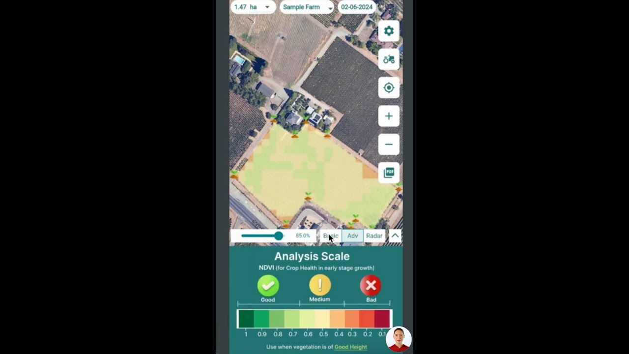
- Apply NDVI (Normalized Difference Vegetation Index) to survey plant health across your fields.
- Detect areas showing chlorophyll content variations, indicating nutrient deficiency or early disease onset.
-
Conduct Soil Moisture Assessment to Optimize Irrigation Scheduling
- Access real-time soil moisture levels using space-based sensors for more efficient water management.
- Reduce water wastage and ensure crops are neither underwatered nor overwatered by using Farmonaut’s crop and soil monitoring tools.
-
Leverage Weather Forecasting for Farmers to Make Informed Decisions
- Receive short- and long-range weather forecasts for proper planning of sowing, fertilization, and harvest operations.
- Mitigate risk of weather extremities by proactively adapting farming activities to forecasted conditions.
-
Implement Land Use Mapping in Agriculture for Smart Crop Planning
- Utilize land cover and land use maps to identify the best zones for specific crops based on historical productivity and soil type.
- Monitor and prevent deforestation or land degradation for sustainable resource management.
-
Apply Satellite-Based Pest and Disease Early Warning Systems
- Detect anomalies in plant growth patterns with AI-enabled interpretation of imagery, allowing early intervention for pests and diseases.
- Use remote monitoring to trigger timely pesticide application, reducing chemical inputs and crop losses.
-
Engage in Yield Prediction and Farm Resource Optimization
- Combine satellite-based crop growth data and historical yields for accurate yield forecasts.
- Use predictions for financial planning and to secure access to crop loans or insurance (see Farmonaut’s crop loan and insurance verification solutions).
-
Monitor and Report Carbon Footprinting for Environmental Compliance
- Harness satellite-enabled tracking of farm emissions and carbon sequestration.
- Adopt regenerative agriculture and sustainability solutions using Farmonaut’s carbon footprint monitoring tools.


“Real-time satellite data can improve yield predictions by up to 30% through precise soil moisture and crop analysis.”
3. Key Applications Explained: Satellite Technology in Agriculture
Crop Health Monitoring & Assessment
Advanced multispectral and hyperspectral imagery enables granular crop health monitoring. Satellites such as ESA’s Sentinel-2 capture visual, near-infrared, and short-wave infrared data to assess:
- Chlorophyll content—healthier crops reflect different light wavelengths.
- Leaf Area Index (LAI)—density and vigor of crop growth.
- Water stress levels—areas lacking moisture can be intervened on time.
By overlaying NDVI maps with historical crop data, farmers gain actionable insights for effective resource allocation, preemptive disease detection, and yield-optimizing interventions.
Soil Moisture Assessment & Irrigation Management
Satellites like NASA’s SMAP provide near real-time soil moisture measurements via active and passive sensors. This supports:
- Irrigation scheduling for maximum efficiency and minimal waste.
- Water resource conservation—critical in drought-prone areas.
- Proactive risk management to prevent yield loss from under- or overwatering.
Paired with AI and field-level weather data, moisture maps lead to precision farming solutions for sustainable agriculture practices.
Weather Forecasting for Farmers
Weather satellites offer daily, weekly, and seasonal forecasts, crucial for planning every stage of the agricultural cycle. Benefits include:
- Protection from weather risks (frost, heatwaves, hail, floods).
- Efficient timing of activities like sowing and harvesting.
- Integration with crop health models for holistic risk mitigation.
Access these insights directly via Farmonaut’s web and mobile platforms for more informed, proactive decisions.
Land Use Mapping in Agriculture
Land use mapping via satellite imagery enables better farm planning:
- Identify arable plots, fallow zones, forest boundaries, and degradation areas.
- Strategic crop allocation for maximum output and environmental balance.
- Monitor and measure land conversion or conservation efforts.
Learn more about agricultural remote sensing.
Disaster Management and Risk Assessment
In the event of floods, droughts, or wildfires, swift assessment by satellites ensures:
- Rapid estimation of crop damage and losses.
- Guidance for insurance claims or government relief disbursements.
- Planning for resilient, future-ready agriculture in risky geographies.
Find out how real-time satellite insights fortify food security in crises via Farmonaut’s disaster assessment solutions.
Yield Prediction & Resource Planning
– Merge historical yield data with current satellite-based growth models for more accurate harvest forecasts.
– Guide logistics, storage, and financial decisions, including access to crop loans and insurance.
With these key applications, farmers and agronomists are empowered to make timely, evidence-based choices enhancing both sustainability and crop profitability.
4. Benefits of Satellite Technology in Agriculture
Utilizing satellite technology in agriculture leads to measurable improvements, offering a comprehensive toolkit that addresses the sector’s evolving needs. The major benefits encompass:
- Enhanced Decision-Making: Real-time, high-resolution satellite data enables farmers to make informed choices about planting dates, irrigation, fertilization, and harvest timing.
- Sustainable Agriculture and Environmental Conservation: Insights from satellite-based monitoring help minimize water usage, control soil erosion, and improve nutrient management, supporting conservation and a more eco-friendly approach.
- Risk Mitigation: Early warning of plant diseases, pest infestations, and adverse weather supports agile, targeted interventions to prevent large-scale crop losses.
- Economic Gains: By optimizing resource allocation, reducing input costs, and increasing output, satellite-driven decisions boost the net profitability of farming operations.
- Accessibility and Scalability: The latest tools, such as those offered via Farmonaut’s affordable web/mobile apps, make precision ag accessible to farms of all sizes.
- Transparency and Traceability: Technologies like Farmonaut’s blockchain-based traceability enhance supply chain transparency and consumer trust.
- Reduced Environmental Footprint: Quantify and track emission reductions with carbon footprinting modules while supporting climate-smart agriculture initiatives.
These benefits underline why satellite imagery for farming and data-driven agriculture are fundamental for global food security and long-term agricultural sustainability.


5. Comparative Table: Benefits of Satellite Technology Applications in Agriculture
| Satellite Application | Function | Estimated Yield Improvement (%) | Environmental Impact |
|---|---|---|---|
| Crop Health Monitoring |
|
10–20% (by timely reactive measures) |
|
| Soil Moisture Assessment |
|
15–30% (through optimal water usage) |
|
| Irrigation Planning |
|
10–25% (reducing crop loss & maximizing growth potential) |
|
| Pest & Disease Detection |
|
10–18% (via reduced spread and losses) |
|
| Yield Prediction |
|
20–30% (enabling better planning & risk reduction) |
|
6. Challenges in Agricultural Satellite Data Adoption
Despite the many benefits, several challenges continue to affect the accessibility and integration of satellite technology in agriculture:
-
Data Accessibility and Cost:
While major agencies offer some free satellite imagery, high-resolution, up-to-date data often require paid subscriptions. Ensuring cost-effective access is key for small and medium-sized farms. -
Data Interpretation and System Integration:
Raw satellite data are complex; actionable insights require specialized platforms and AI-empowered analytics. Seamless integration with traditional farm management tools is an ongoing hurdle. -
Technological Literacy and Adoption:
Not all farmers possess the tech-savvy needed for digital tools. Localized training, intuitive interfaces, and mobile-friendly applications are essential. -
Internet Connectivity:
Reliable, real-time access to cloud-based data and AI-driven forecasts depends on connectivity, which can be limited in rural areas. -
Data Security and Privacy:
Safeguarding sensitive farm data is crucial, especially in regions where compliance with privacy laws is evolving.
Ongoing efforts focus on advancing affordable tech, boosting digital skills, and reducing adoption barriers through user-friendly apps and APIs. For developers and agritech businesses wishing to integrate Farmonaut’s satellite and weather data into their solutions, robust API access is available here and detailed developer documentation is found here.
7. Future Prospects: AI, Sustainability, and Advanced Satellites
Looking forward, the future of satellite technology in agriculture is being shaped by:
-
AI and Machine Learning:
AI supercharges the interpretation of vast satellite datasets, enabling predictive analytics for regenerative agriculture, real-time advisory, and automated reporting.
For example, AI is streamlining soil carbon monitoring and reporting, accelerating the global adoption of regenerative, climate-friendly practices. -
Purpose-Built Agricultural Satellites:
Missions such as EOS SAT-1 are dedicated to precise, agri-centric imagery and faster updates, specifically supporting precision farming solutions worldwide. -
Blockchain-based Traceability and Compliance:
Ultra-secure, transparent ledgers such as those in Farmonaut’s traceability modules will soon be industry-standard, responding to global consumer demands for food safety and authenticity. -
Expansion of Satellite-Enabled Decision Support:
With granular soil moisture assessment, dynamic weather forecasting for farmers, and real-time crop health monitoring, satellite-based intelligence will support everything from large-scale plantation management to smallholder productivity.
With every new launch and digital platform update, the potential for improving crop yields with technology expands—making sustainable, climate-resilient, and profitable farming possible for more agriculture professionals globally.
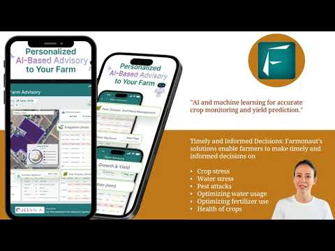
Farmonaut’s Role in Affordable Satellite Technology for Agriculture
As a leading provider of satellite-based agriculture technology solutions, Farmonaut is committed to making precision agriculture both affordable and accessible worldwide. Here’s how we streamline the journey from space data to field-level action:
-
Comprehensive, Cross-Platform Solutions:
Our farm management platform is available as a web browser and mobile app (Android & iOS), ensuring real-time connectivity and usability for every farmer, manager, or administrator. -
AI-Driven Crop Health Monitoring:
We leverage multispectral satellite imagery to deliver timely insights on plant health, soil moisture, and vegetation vigor – helping create responsive, profitable farming practices. -
Personalized AI Farm Advisory:
Farmonaut’s JEEVN AI provides farm-specific advice, integrating satellite data with dynamic weather forecasting and expert guidance for resource optimization. -
Blockchain-Powered Traceability:
Our blockchain-based solutions guarantee complete transparency for agri-commodities—crucial for exporters, food brands, and compliant agribusinesses. -
Scalable Fleet & Resource Management:
For plantations, agribusiness, and contractors, our fleet management features streamline operations, safety, and logistics. -
Carbon Footprinting and Sustainability:
Our platform helps agribusinesses quantify and reduce their emissions, supporting climate-smart agriculture and regulatory compliance. -
Diverse API Integrations for Developers:
Developers can embed our satellite and weather data into their own platforms via robust APIs – Ideal for ecosystem expansion, custom dashboards, and agri-finance/insurance integrations. -
Flexible Subscription Pricing:
Farmonaut operates on a flexible, transparent subscription basis—choose by farm size, data frequency, or specific module to match your unique agricultural needs.
With Farmonaut, access advanced agricultural satellite data, crop health monitoring, soil moisture assessment, and more, through an intuitive, cost-effective platform. Try our Farmonaut app today and experience the true potential of proactive farm management.
Frequently Asked Questions (FAQs) – Agriculture Satellite Technology & Farmonaut
Q1. What is satellite technology in agriculture, and why is it important?
Satellite technology in agriculture uses Earth-observing satellites and advanced sensors to capture critical data about crop health, soil moisture, weather patterns, and land use from space. This information allows for evidence-based and sustainable decision-making, leading to higher productivity, resource efficiency, and reduced environmental impact.
Q2. How do multispectral and hyperspectral satellites improve crop health monitoring?
They capture light reflected by crops in multiple wavelengths, highlighting plant stress, disease, chlorophyll content, and other vital health indicators that are invisible to the naked eye. This enables early detection and timely responses to threats such as pests, diseases, or drought.
Q3. What is soil moisture assessment, and how is it performed via satellites?
Soil moisture assessment uses satellite-based active and passive sensors to map and measure water levels in the soil across large areas. The data enables farmers to optimize irrigation, conserve water resources, and avoid over- or under-watering their crops.
Q4. How does satellite data help with risk management in agriculture?
Satellite monitoring gives early warnings of extreme weather events, pest outbreaks, and crop stress, allowing for timely interventions that minimize yield losses and enhance farm resilience. Integration with AI further boosts predictive capabilities.
Q5. What services does Farmonaut offer to leverage satellite technology in agriculture?
Farmonaut offers satellite-powered crop health and soil moisture monitoring, real-time AI-driven advisory, resource and fleet management tools, carbon footprint reporting, and blockchain-based supply chain traceability – all accessible from a single, user-friendly web and mobile application.
Q6. How accessible and affordable is satellite data for smallholder farmers?
Farmonaut’s subscription and app-based model democratizes access, allowing small and mid-sized farmers to gain the benefits of high-tech, data-driven farming without the prohibitive costs typically associated with traditional precision ag hardware.
Q7. Can other platforms and apps integrate Farmonaut’s satellite data?
Yes! Farmonaut offers robust APIs for developers and businesses to integrate agricultural satellite and weather data, enabling innovation and the development of customized agri-tech solutions. Refer to the open Farmonaut API and developer documentation.
Q8. What is the environmental impact of satellite technology in agriculture?
By enabling optimal input use, preventing over-fertilization or over-irrigation, and supporting carbon footprint monitoring, satellite technology helps reduce water waste, soil degradation, and greenhouse gas emissions, while supporting biodiversity and sustainability.
Conclusion: Leveraging Satellite Technology for a Sustainable Agriculture Future
Satellite technology in agriculture, reinforced by AI, blockchain, and cloud-based analytics, is at the heart of modern precision farming solutions. These powerful tools offer real-time, reliable, and actionable information for crop health monitoring, soil moisture assessment, weather forecasting, and land use mapping, enabling smarter and more sustainable decision-making.
While challenges like cost, data interpretation, and access persist, platforms such as Farmonaut drive the democratization of advanced agricultural satellite data, helping to level the playing field for farmers globally. By adopting these innovative technologies, the world’s agricultural sector stands to attain increased yields, resilience to climate challenges, economic stability, and environmental sustainability.
The time to harness the power of satellites for agriculture is now. Start making data-driven decisions for healthier farms, higher yields, and a more sustainable planet.
For advancing your business or research with agricultural satellite data, don’t forget to consult our API and developer docs.


